Tag Archives: Maritime Domain Awareness

Mapping Gray Maritime Networks for Hybrid Warfare

By Chris Callaghan, Rob Schroeder, and Dr. Wayne Porter

Introduction 

In light of the current National Security Strategy and the 2018 National Defense Guidance, the impact of hybrid warfare and ‘gray-zone’1 maritime activity in support of great power competition among nations has become an increasing area of concern. This includes the need for an increased focus on the identification and tracking of vessels of interest (VOI) and their associated owners, operators, and activities. Traditionally, maritime domain awareness (MDA) has consisted of intelligence, surveillance, and reconnaissance of activities at sea with limited cross-domain link analysis2 of events, carriers, and sponsors (Wallace & Mesko, 2013). While this methodology enables analysts and operators to sift and structure vast data from increasingly complex systems, it fails to consider how ties between similar entities create gray (non-transparent) shipping networks capable of supporting state-directed hybrid warfare. 

This is not to say that a network perspective has been absent from the maritime domain. Researchers from diverse analytic disciplines have conceptualized various constructs as networks, such as historic trade routes (Rivers, Evans, & Knappett, 2016; Wang, Notteboom, & Yang, 2016), global shipping patterns (Ducruet, Rozenblat, & Zaidi, 2010), cruise ship itineraries (Rodrigue & Notteboom, 2014), and logistics involved in global shipping (Ducruet & Lugo, 2013). Yet, much of the focus behind this work has been on understanding transparent (licit) networks.3 For their part, network researchers leveraged social network analysis to gain an understanding of dark networks – that is, covert and/or illicit organizations (Raab & Milward, 2003). This has included, for example, the study of terrorist groups (Krebs, 2002; Roberts & Everton, 2011), narcotic distribution networks (Morselli & Petit, 2007), street gangs (Papachristos, Hureau, & Braga, 2013), and cyber criminals on the dark web (Dupont, 2014) to name a few. 

We drew on network analysis (NA) to examine gray maritime networks (alternately operating licitly and illicitly) in relationship to two NATO-led exercises in 2018: BALTOPS and Exercise Trident Juncture. As previously demonstrated through research focused on mapping gray maritime networks in the South China Sea (Porter, et al., 2019), NA methods can be leveraged to develop longitudinal network depictions of vessels loitering in sensitive or disputed areas. Here, we leverage commercially available geo-temporal data, open-source databases, and home range detection algorithms to generate depictions of the subgroups of owners and operators associated with gray activities.

Although methodology driven, this research was not intended to provide solely an academic contribution but also to demonstrate how NA can improve real-time awareness and tracking for operational purposes. The methods and analysis presented here should enable a rich discussion of current and future methods for enhanced MDA. As such, we begin with a description of our data collection and methods then proceed to discuss findings and practical implications for MDA. Finally, we conclude with a series of recommendations for further research. 

Generating Networks: Data and Methods 

We use commercially available ship tracking data as the cornerstone of our analysis; specifically, in the process of identifying and tracking VOIs. Our team collected the feeds from commercial automatic identification system (AIS) transceivers from 13 March 2018 through 7 January 2019.4 These data points are particularly salient as AIS transmitters are required as navigation and anti-collision systems for all vessels exceeding 300 gross tonnage operating internationally, any vessels exceeding 500 gross tonnage not conducting international voyages, and all passenger ships regardless of size. To narrow the scope of our data set, we geofenced our data to include the Baltic Sea and the North Atlantic Ocean. The resulting daily AIS tracking logs provided both spatial and temporal variables relevant to our analysis; namely, a VOI’s date and time of transmission, maritime mobile service identity (MMSI) number, speed over ground, longitude, and latitude.  

Once the data was decoded and filtered, we proceeded to explore traffic patterns using the Time Local Convex Hull (T-LoCoH) method originally developed for the study of movement patterns in GPS-tracked ranging animals. T-LoCoH integrates time with space into the construction of local hulls (geometric shapes containing a location distribution within a home range) while accounting for an individual animal’s speed, which facilitates the use of metrics for revisitation and loitering duration (Lyons, Turner, & Getz, 2013). In our work, the AIS data that tracks vessel traffic over time and space is analogous to the GPS data used to analyze ranging animals. As such, we leveraged the application of this method to identify spatio-temporal patterns of ships loitering in areas proximal to NATO-led military exercises.  

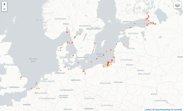
To reduce traffic noise, we only included AIS transmissions for non-NATO nation commercial vessels transponding with a speed over ground less than or equal to two knots. We then generated spatial loitering polygons which may represent ports, anchorages, or other areas where a VOI loitered during the window of research (see Figure 1). As expected, areas exhibited differing loitering densities with some being dense (depicted as yellow on Figure 1) and others less dense (depicted in red). These loitering polygons served as the basis for developing a list of VOIs using their MMSI identification numbers as unique identifiers.

Figure 1. Loitering isopleths during BALTOPS (click to expand)

Matching loitering isopleths with the original AIS transmissions used to generate them yielded a ship-to-loitering location table (see Table 1) with a ship’s unique identifier, the AIS message date and time, and the loitering polygon identity. 

MMSI  Date-time  Polygon 
123456789  T=1  Polygon A 
987654321  T=1  Polygon A 
123456789  T=2  Polygon B 
123456789  T=3  Polygon C 

Table 1. Sample ship-to-loitering location table

From this table, we extracted a location-to-location network where loitering areas were interconnected if a VOI traveled from one location to the other location. Next, to examine the underlying organizations linked to the VOIs, the team gathered open-source information on the companies who own and/or operate these ships using the Lexis Nexis Advance Research Database. This corporate information was then joined to the ship data. The corporate information was used to create connections between companies if they were tied to the same ship, one was a subsidiary of the other, one had a major financial stake in the other, shared the same physical address, or had members of their boards of directors in common. The findings and analysis of these data follow in the subsequent section.

Analysis: Shedding Light on Gray Maritime Networks

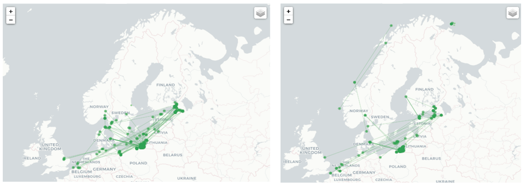
From the AIS data on ship movements we extracted two networks for further analysis: the location-to-location network composed of loitering areas observed during BALTOPS (31 May 2018 through 16 June 2018) and loitering areas observed during Operation Trident Juncture (22 October 2018 through 25 November 2018).  Most of the VOI activity was concentrated within the Baltic Sea (see Figure 2). These findings are to be expected considering the geographic range of operations. While most VOIs in the sample set remained in the Baltic Sea, a few were also observed loitering off the coast of Norway during NATO exercise Trident Juncture.

Figure 2. Location-to-location networks during BALTOPS (left) and Operation Trident Juncture (right) (click to expand)

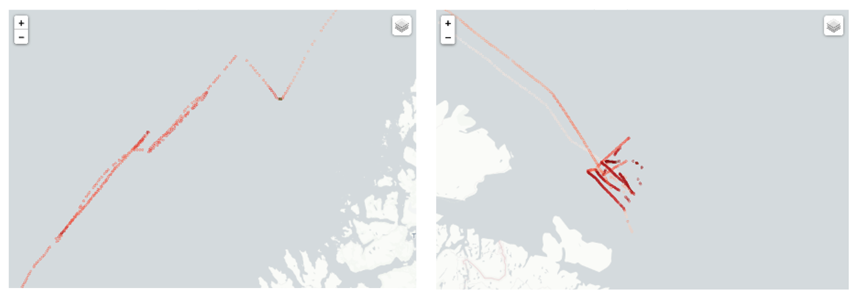
Upon closer examination, the VOIs active off the coast of Norway during Trident Juncture appear to have loitered near sensitive military locations and displayed abnormal movement patterns. For instance, Figure 3 illustrates the movements of two VOIs with abnormal tracking patterns. The first is an oil tanker owned by the Russian government and operated by a registered shipping company in that country. The second is a commercial chemical products tanker registered in the Marshall Islands, a country often used as a flag of convenience, shown loitering north of Norway.

Figure 3. Abnormal shipping patterns off the coast of northern Norway during Operation Trident Juncture, a Russian owned oil tanker (left) and chemical products tanker registered to the Marshall Islands (right) (click to expand)

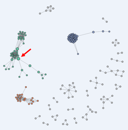
Finally, Figure 4 is a network representation of connections between the companies associated with identified VOIs. In this graph, we see that many of the companies are related to each other, with the three largest components colored in blue, green, and orange. For instance, the large blue cluster on the right-hand side of the sociogram contains many small companies, all operating from the same address in northern Russia, each with connections to at most a few ships. The large orange component on the bottom left contains clusters of VOI-associated companies interconnected by sharing some of the same board members. In the green component, shipping companies associated with VOIs are connected by sharing parent, subsidiary, or holding companies. Companies occupying an apparent position of structural brokerage are depicted by larger nodes. One such shipping company (highlighted with an arrow), for instance, was connected to the broader family of like-companies, while also being linked to a large multinational oil company through partial ownership ties (Schelle, 2018).

Figure 4. Company-to-company network. The three largest components are colored and nodes are sized by brokerage potential.

Conclusions and recommendations for further research 

This analysis highlights the value of NA in real-time awareness and tracking of stakeholders associated with suspected gray maritime activities in a strategic era of great power competition. Using commercially available geospatial data, our team identified 56 VOIs loitering in areas proximal to NATO-led exercises in the Baltic Sea and North Atlantic. These vessels were then linked to over 196 state-owned and private companies/entities. Analysis such as this provides insight into a network of stakeholders that may support hybrid warfare, or so-called grey-zone activities, not directly attributable to a specific nation.

The use of the network analysis methodologies discussed here and the tools developed at the Naval Postgraduate School to identify, map, and track gray maritime networks can be applied to any number of threats. While our earlier research into Chinese reef enhancement activity in the South China Sea has already been cited, Maritime Operations Center (MOC) operators and MDA analysts could adapt this toolset to track and assess maritime and terrestrial networks associated with narcotics trafficking, terrorism, Illegal and Unregulated Fishing (IIU), arms and human trafficking, and other security concerns. Integrating these tools into existing MDA systems would also provide for enhanced awareness of how these networks overlap in multiple geographic areas and in malign activities. Further, and perhaps most significantly, they could provide operators timely and actionable information.   

Our research is not without room for improvement. Future iterations of this work should include a richer dataset of state/corporate linkages. This should include a deeper dive into state-sponsored (and military supported) parent-subsidiary company relationships and board memberships, or proximal geographic associations among companies, offices, and ships. Further research is also being considered through the application of system dynamics modeling, wargaming, campaign analysis, and discrete events modeling. 

Acknowledgment  

The authors would like to acknowledge that this research benefited immensely from the partnership between the Common Operational Research Environment (CORE) Lab and Littoral Operations Center at the Naval Postgraduate School, with the Norwegian Defense Research Establishment (Forsvarets Forskningsinstitutt, FFI). This research builds on a joint effort to integrate network analysis methodologies into the maritime domain, which won the 2019 NCI Agency’s Defense Innovation Challenge aimed at accelerating technological solutions in support of NATO C4ISR and cyber capabilities.

With more research and interest, these methods can help us better understand the non-linear relationships and feedback mechanisms that contribute to the complexity of great power competition and its manifestations in the maritime domain.

Chris Callaghan is a Research Associate in the Defense Analysis Department’s CORE Lab at the NPS. His work leverages open-source data analytics for understanding and modeling a variety of national and homeland security problems. 

Rob Schroeder is a Faculty Associate for Research in the CORE Lab within the Defense Analysis Department and a PhD Student in the Information Sciences Department at the Naval Postgraduate School (NPS). He is currently researching how to use open-source information gathered largely from social media in order to understand and map the changing dynamics in conflict areas and exploring the use of network analysis to analyze maritime traffic patterns. He has presented some of this research at conferences (INFORMS and INSNA).

Dr. Wayne Porter, CAPT, USN (ret.) is a Senior Lecturer in the Defense Analysis and Systems Engineering Departments of the Naval Postgraduate School, where he also serves as Co- Director of the CORE Lab and Director of the Littoral Operations Center.  He holds a Ph.D in Information Sciences and two Masters of Science degrees – in Computer Science and Joint C4I Systems Technology – from the Naval Postgraduate School.  Military duty included Japan, England, Italy, the Balkans, Bahrain (COMFIFTHFLT ACOS Intelligence and MOC Deputy of Operations in the Persian Gulf/East Africa), and three tours on the personal staff of ADM Mike Mullen, including Special Assistant for Strategy to both the Chief of Naval Operations (N00Z) and Chairman of the Joint Chiefs.  He subsequently served as Chair, Systemic Strategy and Complexity at Naval Postgraduate School in Monterey, California and retired from the Navy in July 2014 after 28 years of active service.  Dr. Porter has contributed to a number of DoD and USN Strategy projects, including serving as systems analyst for the SECNAV’s Strategic Readiness Review.

The views expressed in this paper are those of the authors and do not reflect the official position or policies of the United States Navy or the Department of Defense.

Endnotes

1. The opaque area in which illicit of malign activity co-exist with licit activity.

2. An analytical method for interactively curating and querying relational databases (Cunningham, Everton, & Murphy, 2016). In a link diagram, different types of entities (e.g., ports, events, ships, operators, and personnel to name a few) are tied to each other explicitly with the goal of describing the environment.

3. Those operating overtly and legally.

4. All collected AIS logs were encoded in AIVDM (data received from other vessels)/AIVDO (own vessel information) sentences and required decoding for further analysis.

References

Cunningham, D., Everton, S. F., & Murphy, P. (2016). Understanding Dark Networks: A strategic framework for the use of social network analysis. Lanham: Rowman & Littlefield.

Ducruet, C., & Lugo, I. (2013). Structure and dynamics of transportation networks: models, methods and applications. In J. Rodrigue, T. Notteboom, & J. Shaw, The SAGE Handbook of Transport Studies (pp. 347-364). London: SAGE Publications, Ltd. Retrieved from: http://sk.sagepub.com/reference/hdbk_transportstudies/n20.i1734.xml

Ducruet, C., Rozenblat, C., & Zaidi, F. (2010). Ports in multi-level maritime networks: evidence from the Atlantic (1996-2006). Journal of Transport Geography, 18(4), 508-518. Retrieved from: https://www.sciencedirect.com/science/article/abs/pii/S0966692310000372

Dupont, B. (2014). Skills and Trust: A Tour Inside the Hard Drives of Computer Hackers. In C. Morselli, Crime and Networks (pp. 195-217). New York, N.Y.: Routledge. Retrieved from: https://papers.ssrn.com/sol3/papers.cfm?abstract_id=2154952

Krebs, V. E. (2002). Mapping networks of terrorist calls. Connections, 8(2), 43-52. Retrieved from: http://citeseerx.ist.psu.edu/viewdoc/download?doi=10.1.1.192.4165&rep=rep1&type=pdf

LexisNexis. (2019, 09 01). Lexis advance research. Retrieved from LexisNexis: https://advance.lexis.com/

Lyons, A., Turner, W., & Getz, W. (2013). Home range plus: A space-time characterization of movement over real landscapes. BMC Movement Ecology, 1(2), . Retrieved from: https://movementecologyjournal.biomedcentral.com/articles/10.1186/2051-3933-1-2

Morselli, C., & Petit, K. (2007). Law-enforcement disruption of a drug importation network,. Global Crime, 8(2), 109-130. Retrieved from: https://www.tandfonline.com/doi/full/10.1080/17440570701362208

Papachristos, A., Hureau, D., & Braga, A. (2013). The Corner and the Crew: The Influence of Geography and Social Networks on Gang Violence,. American Sociological Review, 78(3), 417-447. Retrieved from: https://journals.sagepub.com/doi/10.1177/0003122413486800

Porter, W., Schroeder, R., Callaghan, C., Barreto, A., Bussell, S., Young, B., . . . von Eiff, J. (2019). Mapping Gray Maritime Networks. Connections, 39(1). Retrieved from: https://www.exeley.com/connections/doi/10.21307/connections-2019-006

Raab, J., & Milward, H. B. (2003). Dark networks as problems. Journal of Public Adminstration Research and Theory, 13(4), 413-439. Retrieved from: https://arizona.pure.elsevier.com/en/publications/dark-networks-as-problems

Rivers, R., Evans, T., & Knappett, C. (2016). From oar to sail: The role of technology and geography in the evolution of Bronze Age Mediterranean networks. In C. Ducruet, Maritime Networks: Spatial structures and time dynamics(pp. 63-76). New York: Routledge.

Roberts, N., & Everton, S. (2011). Strategies for Combating Dark Networks. Journal of Social Structure, 12(2). Retrieved from: https://www.cmu.edu/joss/content/articles/volume12/RobertsEverton.pdf

Rodrigue, J., & Notteboom, T. (2014). The geography of cruises: itineraries, not destinations. Applied Geography, 38(1), 31-34. Retrieved from: https://www.sciencedirect.com/science/article/abs/pii/S0143622812001373?via%3Dihub

Schelle, S. (2018). Kartlegging av maritime hybride trusler: Kan bruk av stordata og sosial nettverksanalyse bidra til økt maritim situasjonsbevissthet? [Survey of maritime hybrid threats: Use of big data and social network analysis to help increased maritime situational awareness?]. Retrieved May 06, 2020, from https://fhs.brage.unit.no/fhs-xmlui/bitstream/handle/11250/2583966/2018%20Masteroppgave%20Schnelle%20Stian.pdf?sequence=1  

Wallace, T., & Mesko, F. (2013, September 30). The Odessa Network: mapping facilitators of Russian and Ukrainian Arms Transfers. Retrieved 09 2019, from C4ADS.org: https://static1.squarespace.com/static/566ef8b4d8af107232d5358a/t/56af8a2dd210b86520934e62/1454344757606/The+Odessa+Network.pdf 

Wang, L., Notteboom, T., & Yang, L. (2016). British and Japanese Maritime Networks in China in the 1920s. In C. Ducruet, Maritime Networks: Spatial structures and time dynamics (pp. 112-133). New York: Routledge.

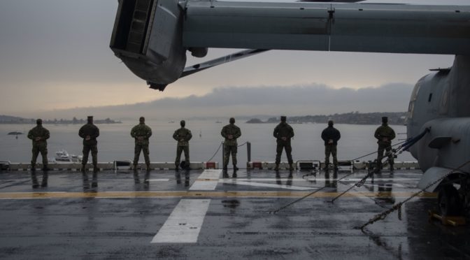
Featured Image: OSLO, Norway (Nov. 13, 2018) Sailors and Marines man the rails as the Wasp-class amphibious assault ship USS Iwo Jima (LHD 7) arrives in Oslo, Norway, for a scheduled port visit Nov. 13, 2018. (U.S. Navy photo by Mass Communication Specialist 3rd Class Daniel C. Coxwest/Released)

The Gulf of Guinea is Ready for Maritime Technology

By Dr. Ian Ralby, Dr. David Soud, and Rohini Ralby

Few regions of the world have seen more improvement in maritime security institutions over the last five years than the Gulf of Guinea. At the same time, however, maritime security threats across West and Central Africa have continued to evolve and are increasingly difficult to address. Ironically, the region is becoming a victim of its own success: improved maritime law enforcement drove criminals to become both more brazen and more innovative in how they pursue illicit profit. These heightened challenges, however, are no longer as insurmountable as even basic ones were a decade ago. Having built one of the most sophisticated and promising sets of maritime security architecture in the world, the Gulf of Guinea is actually well-placed to take on the new challenges it faces.

To maximize the efficiency and effectiveness of this architecture in confronting these threats, a new element has to enter the conversation: technology. States, zones, regions, and the wider interregional mechanisms must all explore ways of leveraging technology to realize their respective mandates in the most cost effective way. Five years ago, discussing maritime technology would have been of limited value, as the state and cooperative mechanisms across West and Central Africa were too nascent to take advantage of it. Now, however, the Gulf of Guinea is primed to make better use of maritime security technology. 

The Gulf of Guinea Has Momentum

While progress in developing functional maritime security in the Gulf of Guinea may not have been as fast as some would prefer, it is now moving rapidly, and its trajectory is unmistakable. The signing of the 2013 Code of Conduct Concerning the Repression of Piracy, Armed Robbery against Ships, and Illicit Maritime Activity in West and Central Africa – known informally as the Yaoundé Code of Conduct – catalyzed an intensive process of national, zonal, regional, and interregional improvement that continues to gain momentum. As Article 2 of the Code states, “the Signatories intend to co-operate to the fullest possible extent in the repression of transnational organized crime in the maritime domain, maritime terrorism, IUU fishing, and other illegal activities at sea.” This initiative has given rise to a multi-tiered effort.

The Gulf of Guinea (Osservatorio Strategico 2017 – Year XIX issue IV)

At the national level, states are working to establish interagency processes for maritime governance, and to develop and implement national maritime strategies. States will remain the fundamental building blocks of maritime security in the Gulf of Guinea. Only through the national laws of the regional states can maritime crimes be effectively prosecuted. Beyond these national efforts, however, the states are engaging in an increasingly integrated, multilateral architecture that facilitates seamless cooperation.

The states, including the landlocked signatories to the Yaoundé Code of Conduct, are grouped by their respective Regional Economic Communities (REC) into maritime Zones. The Economic Community for Central African States (ECCAS) has Zones A and D (there is neither a B nor a C) and the Economic Community for Western African States (ECOWAS) has Zones E, F, and G. The national groupings are as follows, with an asterisk indicating each country that hosts a Zonal Multinational Coordination Center (MCC):

  • Zone A: Angola, Democratic Republic of Congo, Congo
  • Zone D: Cameroon*, Equatorial Guinea, Gabon, São Tomé and Príncipe
  • Zone E: Nigeria, Benin*, Togo, Niger
  • Zone F: Ghana*, Côte d’Ivoire, Burkina Faso, Sierra Leone, Liberia, Guinea
  • Zone G: Cabo Verde*, Senegal, the Gambia, Guinea Bissau, Mali

Each REC also has a corresponding Regional Coordination Center – CRESMAC for ECCAS based in Pointe Noir, Congo, and CRESMAO for ECOWAS based in Abidjan, Côte d’Ivoire. The two regional centers interact and share information with the MCCs to ensure operational cooperation across their respective areas of responsibility.

At the apex of the architecture is the Inter-regional Coordination Center (CIC) in Yaoundé – the intersection of the operational, strategic, and political aspects of maritime safety and security in the Gulf of Guinea. CIC both coordinates and supports the work of the two regional centers, the five zones, and the 25 member states. At the same time, it has the important role of engaging both with international partners and national governments to build political will and ensure the Gulf of Guinea’s momentum continues.

Importantly, the Yaoundé Architecture for Maritime Safety and Security (YAMSS), as the institutional framework is often called, is not merely a nice idea on paper; it is increasingly producing real results on the water. Furthermore, the community of maritime professionals involved in implementing this architectural design are increasingly connected with each other and working collectively to make maritime safety and security a reality in the Gulf of Guinea. As perhaps the most notable example, Zone D already serves as a leading example of how to conduct systematic combined operations at sea for maritime security, not just in Africa but around the world. CRESMAC and CRESMAO are becoming increasingly operational in sharing information across their regions and with each other. And CIC is beginning to garner the attention needed to be successful. At every level, there are encouraging signs of growing momentum and increased community among the maritime professionals in West and Central Africa.

Most technology for maritime law enforcement is procured at the national level. Given the extent of the integration within the Yaoundé architecture, however, there is also an opportunity for technology to be procured at the zonal, regional or inter-regional levels to ensure harmonization, to streamline access to common, inherently interoperable systems and provide a uniform operating picture. 

Technology, some procured within the Gulf of Guinea and some provided by international partners, has been a part of this process from the start. Most of it has involved enhancing visibility to improve maritime domain awareness (MDA). But with the growing coordination across states and regions, and the problem-solving and advance thinking that expansion has generated, key stakeholders have crossed a threshold: they can now discern with confidence what technologies will actually help maximize the impact of maritime operations. The lessons learned along the way merit careful attention from anyone seeking to leverage technology for improved maritime security. What follows are some of those insights.1

Avoiding Information Overload 

Improving MDA has been a major focus for years in Africa. But there is a balance to strike: being aware of everything is almost as challenging as being aware of nothing. Efficiency and effectiveness therefore begin with how information is selected and packaged for use on and off the water. Operators from across different maritime agencies share a keen interest in technology that highlights useful, actionable information, and not only collects but also filters input, helping them focus on key areas of concern rather than providing blanket visibility of all maritime activity. Given the region’s limited human as well as financial resources, such technology could guide them toward confidently engaging in targeted interdiction. This holds true for maritime criminal activity as well as fisheries protection.

But to be used consistently and effectively, the technology must be user-friendly as well. Simplicity is an important differentiator between technology that would improve general maritime domain awareness and technology that would actually help operations in law enforcement, fisheries protection, or search and rescue. For instance, artificial intelligence has now made it possible to have an MDA platform that not only shows ship positions and makes recent AIS anomalies visible, but also aggregates a wide range of real-time and historic data and filters them according to selected parameters, providing instant alerts to suspected illegal activity. That array of functions would allow for both launching decisive interdictions and detecting patterns of illicit activity.

Technology Can Facilitate Inter-Regional Harmonization 

When any one state or even zone is perceived to be weaker than its neighbors, in terms of either its laws or its capacity for law enforcement, that state or zone becomes a magnet for criminality. Consequently, a major focus of the YAMSS is on harmonization to ensure consistency in deterring and addressing maritime crime throughout the Gulf of Guinea. Depending on how it is chosen, distributed and applied, technology could either exacerbate the problem or help resolve it.

When one state has a significant technological advantage over its neighbors, the neighboring states are likely to suffer. Conversely, when shared technologies are deployed across neighboring zones and regions, new possibilities arise for communication, coordination, interoperability, and even harmonization of legal and regulatory frameworks. Some technologies, for example, could provide insight across the region as to where IUU fishing and illicit transshipment most frequently occur, or call attention to ships on erratic or otherwise suspicious courses. This could in turn inform legislative or regulatory action as well as operational decision-making at the national or zonal levels to help address maritime problems where they are most acute. Such an approach can therefore help CIC with building the political will to harmonize, as well as help the operators in their planning and execution of law enforcement activities. The more seamlessly technology is deployed across a region, the more difficult it becomes for criminals to find venues for illicit activity. As the name suggests, transnational crime is borderless; a common operating picture across the regions is therefore vital to identifying that illicit activity.

Not only have the maritime institutions evolved in recent years, the available maritime technology has developed greatly. Surveillance systems to identify illicit activity on the water – from illegal fishing to illicit transshipment to trafficking and smuggling – have improved dramatically. Employing this technology means that operators are not merely patrolling on the off chance they encounter illicit activity. The confidence of law enforcement agencies that they will not be wasting fuel and other resources is greatly enhanced by engaging in targeted interdiction of vessels reasonably certain to be committing offenses based on real-time information.

If law enforcement agencies can show that their efficiency is such that they have successful interdictions nearly every time they deploy assets, that success can become contagious. It can help energize the maritime agencies, deter criminal actors, and at the same time build the political will to ensure the longer-term safety and security of the maritime domain. Politicians are persuaded by success, and technology can greatly increase the odds of operational success.

Culprits Do Not Have to be Caught Red-Handed

In addition to facilitating targeted interdiction, advanced surveillance technologies can offer a further benefit. Just as a robber could be arrested at home for a heist caught on closed caption television (CCTV), it is now possible for vessels to be arrested in port for illicit actions committed at sea and recorded using sophisticated maritime surveillance platforms. Though CCTV is not a possibility on the water, other technologies including the use of the vessels’ Automated Information System (AIS), Synthetic Aperture Radar (SAR), and Electro Optical Imaging (EO) can produce high degrees of certainty regarding illicit activity. While states must ensure that their rules of evidence allow for such electronic and digital data to be used in court, this leveraging of historic surveillance data is another way the technology available today can greatly amplify the impact of limited maritime law enforcement resources. 

Technology that helps counter smuggling will inherently benefit two states simultaneously – the state that is losing the smuggled good, and the state that is losing the tax on the importation of that smuggled product. If implemented effectively, technology could disincentivize the smuggling of certain goods. One crucial example of this is fuel: the cost of doing business in illicit fuel could, with effective law enforcement, become higher than that of selling it legally, thereby making it an unattractive business proposition. A suite of technologies such as molecular marking, GPS tracking of shipments, digital documentation, and state-of-the-art metering, strategically implemented across the Gulf of Guinea, would alter the risk-reward calculus and help West and Central Africa eradicate most cross-border smuggling of fuel. These and related technologies could also appreciably mitigate other modalities of illicit trade, including counterfeit tobacco and pharmaceuticals.

Technology that Pays for Itself Sells Itself

For states and multinational bodies working to secure and govern vast maritime spaces that seldom command the political attention they deserve, investments in technology have to bring returns that justify initial and ongoing expenditure. Technologies that enable more streamlined and cost-effective operations, that combat activities that lead to substantial economic losses, or that actively generate revenue in the form of taxes, fees or various kinds of penalties are preferable to those that run at ongoing cost.

Countering IUU fishing, prosecuting environmental crimes, and combating fuel smuggling are three efforts that could hold precisely this kind of appeal. Acquiring new technology that can stem economic losses from depleted fisheries and degraded marine spaces, elicit substantial financial penalties for illegal fishing or environmental, dumping, recover revenues previously lost to fuel smuggling or prevent subsidies fraud may well find more support among decision-makers than procuring more patrol vessels that need to be crewed, fueled, and maintained. And when the technology begins to pay for itself and lead to more success on the water, investing in new patrol vessels that can amplify that success also begins to look more attractive.

If the political classes can see financial return on investment as well as improved maritime safety, security, and sustainability, wider adoption of the technology becomes more likely. Furthermore, if the procurement approach does not put all the economic burden on the purchaser, but rather balances investment and return, the Gulf of Guinea states are more likely to proceed.

Maritime Safety, Security and Resource Protection Can Share Technology 

The Gulf of Guinea Code of Conduct not only laid the groundwork for an inter-regional security architecture, it also established IUU fishing as a crime coequal with piracy, trafficking, oil theft, and other illicit activities. This move made it possible to establish far more effective legal deterrents than the administrative penalties that often accompany fisheries-related crimes. It also allows for more sharing of technology and information across agencies that combat the full range of illicit maritime activities. In light of how such criminal enterprises as IUU fishing, trafficking, and oil theft often overlap, sharing technology in this fashion can close gaps in law enforcement that criminals have all too often exploited.

Given that limited resources become even more limited when they are divided among multiple agencies trying to accomplish similar tasks, this sort of integration could have an immediate impact on maritime safety, fisheries protection and maritime security. Such sharing of resources, however, necessitates a functional interagency mechanism for maritime governance. Thus the state-level work on both whole-of-government approaches to maritime security and integrated maritime strategy development and implementation go hand-in-hand with the prospects for effective use of such technology. 

Technology Can Both Help and Complicate Legal Finish 

One of the most difficult challenges for the Gulf of Guinea, and indeed for any region, is translating operational successes into legal finish. If no prosecutorial or regulatory action is taken to penalize illicit activity, maritime law enforcement becomes a matter of catch and release. Technology can play an important role in assisting with maritime interdiction, but it also has an essential role to play in effectuating legal finish.

That said, a challenge must first be overcome. Not all legal systems have provisions for technological, digital, or electronic evidence. In order to be able to use the evidence provided by the MDA and monitoring, control, and surveillance (MCS) technologies now emerging, the state’s evidentiary rules must be amended to ensure that technology can be used in court. If those evidentiary rules are more permissive, however, there is another possibility for assisting law enforcement.

Traditionally, in the maritime space, perpetrators have to be caught in the act. But, as noted above, technology that provides evidence of illicit activity at sea could potentially be used to arrest vessels at the pier and on their return from a voyage that involved a breach of the law. In other words, limited vessels or a lack of fuel would not be a barrier to arrest and prosecution. Furthermore, regardless of where a vessel was caught, historical data could be used to increase the charges and penalties for prior offenses as indicated by the technology.

Conclusion 

The Gulf of Guinea is ready to more effectively use technology to enhance the work done to develop and operationalize the cooperative maritime security architecture in West and Central Africa. Cost-neutral or even revenue generating technology is most likely to garner the necessary political will, but from an operator’s standpoint, simplicity is also key. In addition to aiding targeted interdiction, technology can help provide the evidence for pier-side arrests and even enhance charges and penalties based on prior illicit activity. That said, legal systems must account for such technological evidence in court. Harmonized legal finish across the Gulf of Guinea must be a central focus, as that is the only way to change the risk-reward calculus and ensure that no state or zone becomes a magnet for crime.

In a larger, more strategic sense, the individual states and regional bodies pursuing greater maritime security and development in the Gulf of Guinea must also work together to harmonize their more foundational approaches to the challenges facing the region. Too often stakeholders presented with the chance to cooperate or collaborate in confronting such issues fall into the trap of viewing that effort in terms of false dichotomies. They may rightly be keen to exercise autonomy in light of a history in which their sovereignty has been compromised. But they may also unhelpfully misinterpret the cooperative and collaborative harmonization of approaches as being a threat to sovereignty. In an effort to maintain their autonomy, they may therefore isolate themselves, and consequently become more of a magnet to the highly cooperative, transnational criminals they face.

Exercising autonomy Losing sovereignty
Isolating Cooperating and collaborating

This diagram reveals how the terms of a dichotomy are never simply binary, but actually part of a cluster of related terms that are often conflated, or defined in varying ways.2 Failing to get outside the “box” formed by these choices can narrow vision and obstruct communication, and thus frustrate efforts at progress. The stakeholders in the Gulf of Guinea must clarify for themselves and each other the difference between exercising autonomy and isolating themselves, and between cooperating or collaborating and losing sovereignty. If everyone can achieve this “outside-the-box” clarity, progress can happen quickly and effectively. While many of the maritime operators recognize these nuanced dynamics, they have a challenge to overcome in convincing their political leadership to move past a limiting dichotomy centered on autonomy, and instead embrace cooperation and recognize the value in sharing resources and technology to secure, govern, and develop the maritime space in the Gulf of Guinea.

The work of maritime professionals in West and Central Africa to pursue safety, security, and sustainability in the maritime domain has already led to some notable successes. Now it is in a position to begin realizing the ambitious vision of successfully securing, governing, and developing the region’s maritime domain. This is where new, better, and more effectively used technology can play a pivotal role by enabling individual states and regional bodies to make far more effective use of their resources to control the maritime space. Stakeholders must now select the right tools for the job – those that provide the necessary precision, simplicity of use, cost-effectiveness, and ability to link efforts across both agencies and maritime boundaries.

Ian Ralby is a recognized expert in maritime law and security, serving as Adjunct Professor of Maritime Law and Security at the US Department of Defense’s Africa Center for Strategic Studies; a Maritime Crime Expert for UNODC; and as CEO of I.R. Consilium, a family business that works matters of security, governance and development.

David Soud is Head of Research and Analysis at I.R. Consilium and works on issues at the intersection of fisheries governance and transnational organized crime.

Rohini Ralby is Managing Director of I.R. Consilium and works on strategy development and implementation.

References

1. A recent public-private conference organized by the US firm I.R. Consilium, LLC in Freetown, Sierra Leone explored this topic and served as the basis for the key points of this article.

2. The diagram is an example of the “fourchotomy,” a strategic tool devised by Rohini Ralby.

Featured Image:  GULF OF GUINEA (April 2, 2014) A U.S. Coast Guard law enforcement detachment member and a Ghanaian navy sailor inspect a fishing vessel suspected of illegal fishing during the Africa Maritime Law Enforcement Partnership. The partnership is the operational phase of Africa Partnership Station and brings together U.S. Navy, U.S. Coast Guard, and respective Africa partner maritime forces to actively patrol that partner’s territorial waters and economic exclusion zone with the goal of intercepting vessels that may have been involved in illicit activity. (U.S. Navy photo by Kwabena Akuamoah-Boateng/Released)

A Retired Coastie’s Perspective on the Revised Strategy

AN OVERVIEW:

IHMAS Success refuels USCGC Waesche RIMPAC2014n considering this strategy, it is clearly not a strategy for war; it is a strategy for maintaining the peace, the sometimes violent peace that has become the new norm. As such, it assumes the Coast Guard will continue exercising its normal peacetime priorities. Still I feel it should provide a guide for transition to a wartime footing. Unless it is in the classified annex, that guidance is missing, in that it does not define Coast Guard wartime roles or suggest how the Coast Guard might be shaped to be more useful in wartime.

The Coast Guard is, potentially, a significant Naval force. It currently has more personnel than the British Royal Navy. Effectively, the Coast Guard is the low end of the American Naval Forces’ High/Low mix, bringing with it significant numbers of patrol vessels and aircraft. At little marginal cost, it could be made into an effective naval reserve that would serve the nation well in an intense conventional conflict.

If you look at the title, “A Cooperative Strategy for 21st Century Seapower: Forward, Engaged, Ready,” the words cooperative, forward, and engaged are particularly relevant in describing the thrust of the strategy.

It expects US naval forces to cooperate and engage with allied and friendly forces both to improve relations and strengthen and encourage those friendly forces. The Coast Guard has a major role in this, in bringing expertise in a board range of governance functions that friendly navies and coast guards can relate to.

The Navy also expects to have a substantial part of its force “forward.” Not only forward but also geographically widely distributed. This violation of the Mahanian maxim to keep your battle force concentrated has been the norm for decades, but it has been a reflection of the preponderance of the US Navy that may be eroding. It is a calculated risk that, the benefits of working with and assuring allies and being on scene to deal with brush fires, outweighs the potential risk isolated, forward deployed Carrier Strike and/or Amphibious Ready Groups might be overwhelmed in a first strike by a concentration of hostile forces.

The strategy talks about surge forces, but frankly the potential is far more limited than it was when the Navy was larger. For the Coast Guard this “forward” strategy, combined with the apparently ever increasing concentration of US Navy forces in only a few homeports, including foreign ports, has important implications. There are long stretches of the US coast that may be hundreds of miles from the nearest US Navy surface combatant.

If a suspicious vessel is approaching the US, that must be boarded to determine its nature and intent, the boarding is most likely to be done by a Coast Guard cutter, and not by a National Security Cutter, but most likely by something much smaller. The cutter is also unlikely to have any heavily armed backup.

WHAT IS INCLUDED IN THE STRATEGY?

The strategy recognizes and explicitly states an intention to exploit, “…the Coast Guard’s unique legal authorities…(to)…combat the illegal drug trade, human trafficking, and the unlawful exploitation of natural resources…”

In several places there is recognition of the Coast Guard’s potential for capacity building with navies and coast guards of friendly nations.

There is also an apparent commitment to an improved and shared Maritime Domain Awareness.

The apparent intent to increase the availability of modular systems provides a means of quickly adapting Coast Guard assets to wartime roles, but thus far I have seen no official interest in exploiting this possibility.

The Middle East Section seems to suggest that the six Coast Guard patrol boats and their augmented crews, currently stationed in Bahrain, will remain there and, given their age, they may require replacement as the new Webber Class WPC, Fast Response Cutters, come on line. In fact these Webber class patrol craft could be very effective in combatting piracy off Somalia.

These patrol craft essentially fill the same role and face the same threats as the Navy’s Cyclone class patrol craft. Will they receive any of the weapons upgrades that the Navy’s Cyclone class PCs have been given?

WPC Kathleen_Moore

A Webber Class WPC, Fast Response Cutter

Looking at the section on the Western Hemisphere, there is a commitment to, “…employ amphibious ships and other platforms, including Littoral Combat Ships, Joint High Speed Vessels, Afloat Forward Staging Bases, hospital ships, other Military Sealift Command ships, and Coast Guard platforms, to conduct humanitarian assistance and disaster response missions. We will also employ maritime patrol aircraft such as the P-8A Poseidon and unmanned aerial vehicles. Other ships and aircraft will provide periodic presence for recurring military-to-military engagements, theater security cooperation exercises, and other missions.” But there is no specific commitment to employ Navy vessels for drug enforcement. Was this omission intentional?

512px-Antarctica_CIA_svg
Competing claims in the Antarctic

Looking at section on the Arctic and Antarctic,  There is no specific commitment by the Navy, although the DOD does have an Arctic strategy that includes better hydrography and Maritime Domain Awareness. It looks like the Navy is content for the Coast Guard to be the face of US naval presence in the Arctic. There is reference to the use of the Nation Security Cutters (NSC) in the Arctic, but surprisingly no mention of the planned 25 Offshore Patrol Cutters (OPC) even though the OPCs will be ice-strengthened, while the eight planned NSCs are not.

IMG_4135

A model of Eastern’s proposal for the Offshore Patrol Cutter. Eastern is one of three shipyards still in contention to  build the 25 ships planned.

In the Deterrence section, the strategy states, “The Coast Guard maintains a continuous presence in our ports, internal waterways, along our coasts, and offshore, providing an additional layer of defense against maritime threats.” But there is no definition of what threats the Coast Guard is expected to respond to and no definition of the capabilities the Coast Guard is expected to provide to deal with these threats.

A Major Omission:

USCGC_Owasco_(WHEC-39)_conducting_UNREP_Market_Time
Cutter Owasco (WHEC-39) unreps while engaged in Operation Market Time off the coast of Vietnam.

In the Sea Control section there is no mention of a Coast Guard role in Sea Control. There should be. Sea Control frequently involves Visit, Boarding, Search and potentially Seizure of non-military vessels, e.g. merchant and fishing vessels. The Coast Guard is ideally suited for this role and has conducted this type of operation in war zones in the past, notably the Market Time Operation during the Vietnam War. In fact, the common Coast Guard missions of drug and alien migrant interdiction are forms of sea control that potentially protect the US from non-state actors. The strategy does address these particular elements of Sea Control in the Maritime Security section.

When it comes to counting assets that might be used to exercise sea control, the Navy has roughly 110 cruisers, destroyers, frigates, LCS, and patrol craft and most of these, particularly the 85+ cruisers and destroyers, will almost certainly have higher priority missions. The Coast Guard includes over 100 patrol boats and about 40 larger patrol vessels that routinely exercise sea control on a daily basis.

121203-G-XX000-001_CPO Terrell Horne

EVALUATION:

From a Coast Guard perspective, this strategy has largely canonized the status quo and the existing recapitalization program of record. It recognizes the Coast Guard’s unique authorities and its ability to contribute to capacity building. It seems to promise greater integration of a multiservice Maritime Domain Awareness.

On the other hand it does nothing to define Coast Guard wartime missions or how the Coast Guard might transition to a wartime footing. The force structure section does nothing to inform the design of Coast Guard equipment so that it might be more useful in wartime. It also does nothing to help that Coast Guard patrol boat I talked about at the beginning that is about to attempt to stop and board a potential hostile vessel that may be about to make an unconventional attack on a US port.

This is only the second iteration of the three service cooperative strategy. It is a marked improvement in specificity over the previous document. Hopefully there will be a process of continual improvement in succeeding editions.

This post appeared in its original form at Chuck Hill’s CG Blog. Chuck retired from the Coast Guard after 22 years service. Assignments included four ships, Rescue Coordination Center New Orleans, CG HQ, Fleet Training Group San Diego, Naval War College, and Maritime Defense Zone Pacific/Pacific Area Ops/Readiness/Plans. Along the way he became the first Coast Guard officer to complete the Tactical Action Officer (TAO) course and also completed the Naval Control of Shipping course. He has had a life-long interest in naval ships and history.

India Reinforces Maritime Domain Awareness but Challenges Remain

Six years ago, in November 2008, a group of Pakistan-based terrorists landed at unsecured waterfronts in Mumbai, the financial capital of India, and attacked public places such as hotels, restaurants, and a railway station. Although the Indian security forces were quick to respond, the attack, popularly referred to as 26/11, exposed three significant gaps in India’s maritime security apparatus: a. the porous nature of India’s coastline; b. the poor surveillance of the maritime domain; and c. the lack of inter-agency coordination.

Indian Navy's marine commandos in action during a mock rescue demonstration at the Gate of India during the Navy Day celebrations in Mumbai, India, 04 December 2010.
Indian Navy’s marine commandos in action during a mock rescue demonstration at the Gate of India during the Navy Day celebrations in Mumbai, India, 04 December 2010.

Post the 26/11 attacks, the Indian government undertook a number of proactive measures to restructure coastal security and push the defensive perimeter further away from the coast into the seas. The focus was on building national maritime domain awareness (NMDA) grid via a number of organisational, operational and technological changes. The Indian Navy has now set up the National Command Control Communication Intelligence (NC3I) network that hosts the Information Management and Analysis Centre (IMAC).

It connects 41 radar stations (20 Indian Navy and 31 Coast Guard) located along the coast and on the island territories, and helps collate, fuse and disseminate critical intelligence and information about ‘unusual or suspicious movements and activities at sea’. There are plans for additional coastal radar stations to cover gap/shadow zones in the second phase; these are currently addressed through deployment of ships and aircraft of the Indian Navy and the Coast Guard.

The IMAC receives vital operational data from multiple sources such as the Automatic Identification System (AIS) and the long-range identification and tracking (LRIT), a satellite-based, real-time reporting mechanism for reporting the position of ships. This information is further supplemented by shore based electro-optical systems and high definition radars. Significantly, maritime domain awareness is also received through satellite data.

There are 74 AIS receivers along the Indian coast and these are capable of tracking 30,000 to 40,000 merchant ships transiting through the Indian Ocean. The AIS is mandatory for all merchant ships above 300 tons DWT and it helps monitoring agencies to keep track of shipping and detect suspicious ships. However the AIS a vulnerable to ‘data manipulation’. According to a recent study, the international shipping manipulates AIS data for a number of reasons, and the trends are quite disturbing.

In the last two years, there has been 30 per cent increase in the number of ships reporting false identities. Nearly 40 per cent of the ships do not report their next port of call to prevent the commodity operators and to preclude speculation. Interestingly, there is growing tendency among merchant ships to shut down AIS, and ‘go dark’ and spoofing (generating false transmissions) is perhaps the most dangerous. It can potentially mislead the security forces who have to respond to such targets and on finding none, leads to loss and wastage of precious time and human effort which adversely affects operational efficiency of the maritime security forces.

At another level, small fishing boats can complicate maritime domain awareness; however, it is fair to say that they can also be the ‘eyes and ears’ of the security agencies. Indian authorities have undertaken a number of steps, including compulsory identity cards for fishermen; registration of over 200,000 fishing boats and tracking them through central database; security awareness programmes, etc. Furthermore, Marine Police Training Institutes have been established. They are coordinated by the apex National Committee for Strengthening Maritime and Coastal Security (NCSMCS) that is headed by the Cabinet Secretary.

thCAH3R4K0The Indian government has also drawn plans to reinforce the NMDA via multilateral cooperation. It is in talks with at least 24 countries for exchanging information on shipping to ensure that the seas are safe and secure for global commerce. India has placed maritime security high on the agenda through active participation in the Indian Ocean Rim association (IORA), the Indian Ocean Naval symposium (IONS), the East Asia Summit (EAS), the ASEAN Defence Ministers Meeting (ADMM) Plus. Additionally, it is in talks with other countries to institutionalise intelligence exchange among the respective security agencies.

The Indian Navy and the Coast Guard have been at the helm and have developed a sophisticated strategy that involves joint exercises, hot lines, exchange of intelligence and training with a number of navies. It will be useful to explore if the NC3I is suitably linked to the Singapore-based Information Fusion Centre (IFC) established at Changi Command and Control Centre (CC2C), which has received much acclaim as an effective MDA hub.

It is fair to argue that weak legislations can compromise maritime security. In this connection, it is important to point out that the Coastal Security Bill drafted in 2013 is yet to be tabled in the Indian Parliament. Unfortunately, the draft Piracy Bill placed before the law makers in 2012 lapsed due to priority given to other issues.

Dr Vijay Sakhuja is the Director, National Maritime Foundation, New Delhi. The views expressed are those of the author and do not reflect the official policy or position of the National Maritime Foundation. He can be reached at director.nmf@gmail.com.

This article is courtesy Institute of Peace and Conflict Studies (IPCS), New Delhi and originally appeared at http://www.ipcs.org/article/india/india-reinforces-maritime-domain-awareness-but-challenges-remain-4764.html.