The RTS crew discusses the recently released Star Wars Battlefront just in time for the new movie. Join us, and new RTS stars August Cole and Crispin Burke, as we discuss everything from Battlefront’s gameplay to galactic TRICARE for the stormtroopers.
“Real Time Strategy,” is a discussion on the lessons and non-lessons of the simulations we use to both learn and entertain in the realm of military strategy, tactics, and history.
The author would like to thank Colombian Rear Admiral (ret.) Luis Fernando Yance Villamil and Colombian General (ret.) Enrique Peña Diaz for their comments and information, which were of invaluable help for this report.
This past August, tensions flared up between Colombia and Venezuela after three Venezuelan soldiers were injured in an incident along their common border. The situation worsened as Caracas started deporting undocumented Colombians that live in Venezuela. Thankfully, diplomacy prevailed and the incident did not escalate. Nevertheless, this is not the first time that the two South American countries have been at odds with each other. The two states had confronted one and other before, specifically at sea in 1987 and more recently in 2008.
[otw_shortcode_button href=”https://cimsec.org/buying-cimsec-war-bonds/18115″ size=”medium” icon_position=”right” shape=”round” color_class=”otw-blue”]Donate to CIMSEC![/otw_shortcode_button]
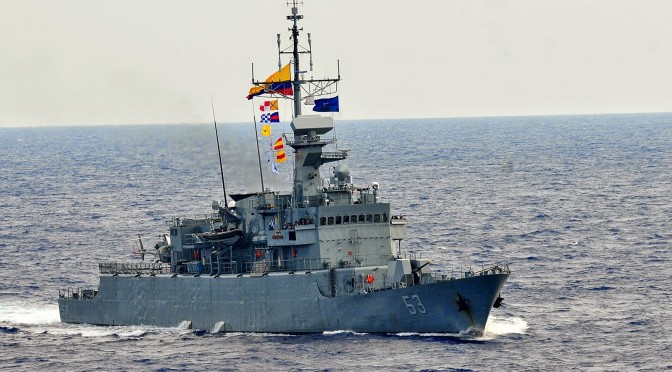
The focus of this analysis is not to theoretically discuss what would happen if Colombia and Venezuela went to war. Rather, we aim to take this possible inter-state conflict as a point of departure to discuss the status of the modern Colombian Navy. For decades, the Colombian Navy’s security operations have revolved around combating maritime crimes like drug trafficking. Nevertheless, a Navy’s raison d’être is to protect a country’s waterways from internal and external threats. Given recent acquisitions, including two German submarines, Colombia’s Navy can certainly be cataloged as a regional powerhouse with a strong deterrent capability.
Lack of Warfare: A Brief History
There is an obscure but also amusing fact about Latin American navies in general: they have not participated in inter-state warfare in decades. As I have discussed in previous analyses, the last time two Latin American countries went to war with each other was the land-based conflict Peru and Ecuador in 1995. Moreover, the last time a Latin American warship fired a missile at another warship was during the 1982 Falklands/Malvinas War between Argentina and the United Kingdom.
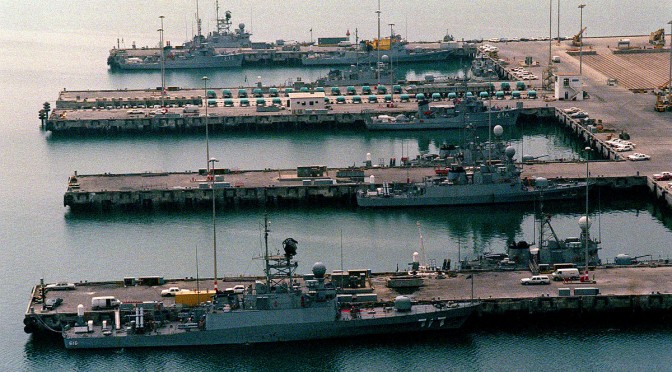
Colombia is well known for the internal conflict that has plagued the country for decades. When it comes to inter-state wars, Colombian Army units and Navy vessels participated in the Korean War, via the UN, while the last conflict Colombia fought with a neighboring state was the 1932-1933 war with Peru, which was centered in the Amazon. In the past few decades, there have been isolated incidents which brought Colombia to an inter-state war. Most recently in 2008, there was a bizarre incident in which Colombian troops attacked a FARC insurgent base in Ecuador without requesting Quito’s permission. Venezuela’s Hugo Chavez deployed his troops to the Colombian border, declaring that he would go to war with Colombia to protect its ally Ecuador. Prior to that, there was the aforementioned 1987 incident in which the ARC Caldas, a Colombian corvette, entered waters that Venezuela claims as its own. Both countries deployed troops to their borders, and Venezuelan F-16 warplanes flew over the ARC Caldas and other Colombian vessels in the disputed area. As was the case with this most recent incident, the crises in 1987 and 2008 ultimately did not escalate.
This leads to one conclusion: there is no one in service in the Colombian Navy that has experience in an inter-state conflict. Moreover, no missile or torpedo has been launched from a Colombian warship or submarine in generations. Certainly, this fact does not minimize the capabilities, bravery, and overall professionalism of Colombian sailors who have plenty of experience in combating insurgents, drug traffickers, and other criminals in the country’s territorial waters and throughout the country’s numerous rivers. If anything, Colombia’s success at stopping maritime crimes (in April, it seized 1.3 tons of cocainein Pacific waters) highlights how this service has adapted and transformed itself into a force that can face both traditional and asymmetric security threats. Nevertheless, it is an amusing factoid that, as powerful as the Colombian Navy is, experience in inter-state conflicts is beyond scarce among its personnel (though the same can be said of other regional navies).
A Force to be Reckoned With
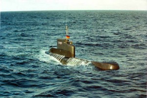
Unlike its neighbor Brazil, Colombia does not possess a carrier, nor is it constructing a nuclear-powered submarine. Nevertheless, its Navy has carried out acquisitions in recent years to modernize its fleet. The most important was the 2012 acquisition of two German-made submarines, class U-206A. The
Colombia acquired two updated U-206A Submarines (pictured here) from Germany.
submarines have been upgraded (they served in the German Navy for over three decades and were decommissioned in 2010) and, at the time of this writing, are been transported from Germany to Colombia via the freighter BBC Saphire.
As for other acquisitions, Bogota has purchased a “fast ferry” transport vessel, the ARC Juanchaco, from the Dutch shipbuilding company Damen. Moreover, Colombia has also acquired a 76mm gun, an Oto Melara 76/62 Super Rapid (SR) Gun Mount, from the Italian company Finmeccanica. It will be placed aboard an offshore patrol vessel that the country is currently constructing. Finally, the Colombian Navy’s official websiteoffers a detailed list of acquisitions and upgrades for 2015; due to space issues we will not discuss them here, but it is worth noting that these include modernizing the country’s frigates and upgrading bases like ARC Bolivar and ARC Malaga.
Additionally, the country’s naval military industry is rapidly evolving. Case in point, the Colombian state-owned shipyard COCTEMAR recently delivered to the Navy the amphibious landing vessel BDA Golfo de Uraba, which can transport supplies to coastal and fluvial areas. This is the second of six vesselsof this class that COCTEMAR is constructing for the Navy.
In terms of training, Colombia carries out military exercises with its neighbors and allies – Colombian warships are currently involved in the UNITAS 2015 exercises with U.S. and other Latin American vessels. Furthermore, the Colombian Navy participated in
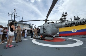
The Colombian Navy offered tours during RIMPAC 2014.
RIMPAC 2014 and carried out naval exercises with Ecuador in August. Finally, a crew of Colombian sailors is getting some first-hand experience in combat operations as the patrol vessel ARC 7 de Agosto has been deployed to the horn of Africa to participate in Operation Atalanta.
Issues and Challenges
While the Colombian Navy has carried out important acquisitions and modernization of its vessels, there are problems among its personnel. Just this past May, Bogota revealed a massive fraud operation among the country’s armed forces in which some 160 million Colombian pesos (around $52 thousand USD) were stolen from the military’s coffers. Among those arrested as part of this criminal ring were three naval personnel and one civilian that also worked for the Navy. The criminals utilized online transactions, using fake documents to wire money from the naval cadet school Almirante Padilla, to personal bank accounts.
Moreover, the education that Colombian naval cadets are receiving may be called into question. The research group Sapiens Research publishes reports of Colombia’s best universities: in 2014, the best military university was the Universidad Militar Nueva Granada, which came at a respectable number 25. As for the navy’s cadet school, the Escuela Naval de Cadetes Almirante Padilla came at a dismal number 90, just above the Air Force’s postgraduate school. Colombian naval cadets receive good training at sea – this is best exemplified by how its flagship and training vessel, the ARC Gloria, has travelled around the worldto provide aspiring naval officers with hands-on experience. Nevertheless, the education they receive on land at their university can greatly be improved if it wants to compete with some of Colombia’s best universities.
Another worrisome development is the training that Colombian marines are receiving. Earlier this year, the Colombian news agency La F.m. uploaded a video showing marines being threatened and physically beaten by their trainers as part of an advanced training course. The marines were punched and kicked by their supervisors, even when they fell to the ground, all the while being verbally insulted. (Click here for the graphic video, in Spanish).
The video sparked a debate on whether such training methods are acceptable (arguably to train the marines to deal with extreme pain in case they are captured by insurgents) or if they should be regarded as humiliating and unnecessary. As a response to the video, Admiral Hernando Wills, commander of the Navy, announced that the officers that beat up the marines had been kicked out of the service. The naval officer explained that “military training is demanding, but under no circumstance does it justify physical abuse.”
Finally, as part of my research, I was unable to find reports of accidents regarding Colombian vessels. This is certainly a positive development, particularly as other branches have suffered accidents in the recent past (one of the Air Force’s Kfir warplanes crashed in December 2014 during a training exercise). With that said, problems among naval personnel, from corruption cases to controversial training, or lack of good education among cadets, must be dealt with in order to continue optimizing the country’s maritime force.
Analysis
While the Colombian Navy has acquired some major equipment, particularly two submarines and new landing vessels, it would be wrong to assume that it is partaking some kind of aggressive weapons-purchase spree. Rather, the Colombian Navy is going through a modernization process to maintain its ability to carry out operations, such as combating maritime crimes, as well as maintaining a deterrent capability from outside threats.
Ultimately, the operations of the Colombian Navy rest on its personnel and its equipment. As previously mentioned, there have not been any major accidents regarding warships or submarines while the recent acquisitions and modernization of vessels leads me argue that the Colombian Navy is in ideal shape to continue its operations and deal with any foreseeable conflict. As for the personnel itself, the corruption case is a problematic incident but has not affected the overall status of the Navy. Of more concern are the (videotaped) cases of physical and psychological abuse against marines during training courses.
The Caracas Question
This analysis would not be complete without discussing Venezuela-Colombia tensions. The two governments have a long history, including been part of the same country in the 19th century. However, tensions have regularly escalated, particularly as they both claim the oil-rich Gulf of Venezuela, which prompted the 1987 maritime crisis. Tensions increased during the presidencies of Venezuela’s Hugo Chavez and Colombia’s Alvaro Uribe, which culminated in the 2008 incident. Sadly, even after the two leaders left power, occasional flare-ups continued, such as this past August.
It is important to note that under Chavez, Caracas spent billions of dollars on Russian and Chinese equipment for the Venezuelan armed forces, but the main beneficiaries were the Army and Air Force. Recent open-source reports hint that the Venezuelan Navy is doing the best with what it has, which means repairing old vessels, like the submarine Caribe, S-32, and its Lupo-class frigates. The country’s acquisitions program can be regarded as modest – one recent example is the purchase of Damen-built patrol vessels.
While it is not my goal to discuss a theoretical Colombia-Venezuela conflict, the information currently available regarding both navies provides a strong advantage to the Colombian Navy, as it has seasoned personnel with combat experience due to their anti-drug trafficking operations and the ARC 7 de Agosto vessel operating in the Horn of Africa. Of course, the caveat here is that the Colombian Navy has not participated in an actual inter-state conflict in decades (but then again, neither has the Venezuelan Navy), which means Colombian naval personnel lack that particular kind of combat-experience. As far as the equipment goes, the current purchases provide the Colombians a formidable force, particularly when it comes to its submarine fleet.
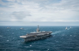
Furthermore, the Colombian Navy enjoys strong relations with regional navies, which means that it participates in valuable multinational training exercises. For example, the ongoing UNITAS 2015 exercises have warships from Colombia, Peru, Mexico, the U.S. among others. On the other hand, the Venezuelan
PHOTOEX from UNITAS 2015
Navy carried out exercises with the country’s Air Force in June. Inter-agency exercises are important, but the Venezuelans are at a disadvantage as the Colombian Navy learns tactics and techniques from other navies.
Regarding the U.S., close Bogota-Washington relations are no secret, both at the political and military level. When it comes to navies, apart from participating in joint maritime exercises, there are often meetings between the senior naval command of both countries. Case in point, this past January, Admiral John Greenert, Chief of Naval Operations of the U.S. Navy, traveled to Colombia to meet with Defense Minister Juan Carlos Pinzon and the commander of the Navy, Admiral Hernando Wills.
Given the plethora of current analyses discussing how far the U.S. government (and military) will go to support their allies (i.e. via NATO in Europe or to protect Taiwan in the Asia Pacific), it is necessary to briefly discuss U.S.-Colombia relations if the South American state went to war; a Colombia-Venezuela conflict being the most plausible scenario. It is safe to say that the U.S. will not go to war over Colombia. Nevertheless, we can deduce that the U.S. would support to its ally, particularly if it is in a war against Venezuela, which has been a thorn in Washington’s side since the dawn of the Chavez era. Specifically, I would argue that Washington would focus provide intelligence to Bogota – a precedent would be the U.S. supplying intel to the UK against Argentina during the Falklands War.
Ultimately, the question is: Is a war between Colombia and Venezuela inevitable? The fact that the crises of 1987, 2008 and 2015 did not result in conflict speaks well of how both governments preferred dialogue over war. Even more, just this past October, senior naval officers from both countries met in Maracaibo, Venezuela to discuss bilateral cooperation to combat crimes, including drug trafficking, along their common border. Such meetings are important confidence-building mechanisms to improve military relations.
Nevertheless, a maritime border in the Gulf of Venezuela has yet to be agreed upon by both governments, which will probably lead to another 1987-type incident in the future. Moreover, the Venezuelan economy remains in a dire state, and the Venezuelan government has turned to constantly accusing foreign actors, namely the U.S., of trying to destabilize it. Even more, Caracas has also accused Bogota of trying to destabilize its economy and fomenting the mega-inflation that Venezuela is currently experiencing. The bottom line here is that accusations over economic warfare and/or unresolved border issues will likely bring about a new round of incidents in the near future. Hopefully these will not end up in a conflict but, in this author’s personal opinion, the Colombian military may be wondering if Venezuela may try to ignite a conflict in order to divert attention from its internal problems (a la Argentina during the Falklands War).
Conclusions
When discussing maritime strength among military powers, it makes sense to focus on navies with either nuclear-powered vessels or in terms of modern equipment. When it comes to Latin America, assessing a navy’s strength is somewhat different as all tend to possess a mix of (sometimes very) old equipment, sprinkled with the occasional new vessel. The Colombian Navy has such a mix of warships and submarines – it has brand-new, domestically-manufactured, landing ships while its “new” German submarines are already over three decades old. Nevertheless, this author would conclude that it enjoys a high level of readiness (best exemplified by successful operations against maritime crimes). While nobody wants war, if it does occur, Colombia’s Navy is certainly a powerhouse to be reckoned with.
W. Alejandro Sanchez is a Senior Research Fellow at the Council on Hemispheric Affairs (COHA) where he focuses on geopolitics, military and cyber security issues in the Western Hemisphere. Follow him on Twitter: @W_Alex_Sanchez
[otw_shortcode_button href=”https://cimsec.org/buying-cimsec-war-bonds/18115″ size=”medium” icon_position=”right” shape=”round” color_class=”otw-blue”]Donate to CIMSEC![/otw_shortcode_button]
The Royal Saudi Navy is planning to replace virtually all of its Eastern Fleet. The expected price tag has been variously reported as between $11.25 and $20B. One of Saudi Arabia’s two fleets, the Eastern Fleet is based in the Persian Gulf and faces off squarely against Iran’s Navy and Revolutionary Guard Corp. The Western Fleet is based in the Red Sea and includes seven French built frigates.
[otw_shortcode_button href=”https://cimsec.org/buying-cimsec-war-bonds/18115″ size=”medium” icon_position=”right” shape=”round” color_class=”otw-blue”]Donate to CIMSEC![/otw_shortcode_button]
The existing Eastern fleet, all American built, includesfour 75 meter (246 foot), 1,038 ton corvettes and nine 58 meter (190 feet), 495 ton guided missile boats. All are nearing the end of their useful lives, having entered service in the early ’80s.
In February Defense News reported that Saudi Arabia had sent a letter of request to the US Navy that outlined the entire program. It specified:
Four 3,500-ton “frigate-like warships” capable of anti-air warfare, armed with an eight-to-16-cell vertical launch system (VLS) capable of launching Standard SM-2 missiles; fitted with an “Aegis or like” combat system using “SPY-1F or similar” radars; able to operate Sikorsky MH-60R helicopters; with a speed of 35 knots.
Six 2,500-ton warships with combat systems compatible with the frigates, able to operate MH-60R helos.
20 to 24 fast patrol vessels about 40 to 45 meters long, powered by twin diesels.
10 “maritime helicopters” with characteristics identical to the MH-60R.
Three maritime patrol aircraft for coastal surveillance.
30 to 50 UAVs, some for maritime use, some to be shore-based.
This shopping list sounds remarkably specific. This suggest that they already have a good idea what they expect to buy.
Four 3,500-ton “frigate-like warships”
Plans have firmed up for the four frigates. While they will not have the Aegis like radars they will have a, “…16-cell (Mk41) VLS installation able to launch Evolved Sea Sparrow missiles, and will carry Harpoon Block II surface-to-surface missiles in dedicated launchers, and anti-air Rolling Airframe Missiles in a SeaRAM close-in weapon system. The MMSC will also mount a 76mm gun… a Lockheed Martin COMBATSS-21 combat management system, which shares some commonality with the much larger Aegis combat system, and feature the Cassidian TRS-4D C-band radar.”
Six 2,500-ton warships with combat systems compatible with the frigates, able to operate MH-60R helos.
The design for the six smaller ships hasn’t been discussed openly, so this is a bit of speculation, but at least I think we can expect something like this. The video below, from Swiftship, recently appeared without much explanation. The similarity in design to the Freedom class is striking and it claims to be a proven hull form. If Marinette Marine is too busy to build these smaller ships in addition to the LCS and the Saudi Frigates, having Swiftships build them might be a way have having them delivered relatively quickly and it looks like it might fit the description. Note there is no mention of an ASW capability for these ships (other than the ability to embark an MH-60R). This parallels the current fleet structure where only the four largest vessels have an ASW capability and the next largest class vessels do not.
Swiftships has a record of selling vessels through “Foreign Military Sales” and the vessel in the video shares a number of systems in common with the projected Saudi frigates including a 76mm gun, RAM missiles, MH-60s, and possibly Harpoon (they show only a generic representation of an ASCM).
20 to 24 fast patrol vessels about 40 to 45 meters long, powered by twin diesels.
A likely choice for the patrol boat is this one, eight of which were sold to Pakistan. Reportedly these 43 meter, 143 foot vessels can make 34 knots and operate a ScanEagle UAS.
Included in the buy of the helicopters are, “one-thousand (1,000) AN/SSQ-36/53/62 Sonobuoys; thirty-eight (38) AGM-114R Hellfire II missiles; five (5) AGM-114 M36-E9 Captive Air Training missiles; four (4) AGM-114Q Hellfire Training Missiles; three-hundred eighty (380) Advanced Precision Kill Weapons System rockets; twelve (12) M-240D crew served weapons; and twelve (12) GAU-21 crew served weapons.”
I note that the 380 Advanced Precision Kill Weapons System (APKWS) semi-active laser homing 70mm rockets is exactly the number to fill twenty 19 round launchers. These weapons are probably an ideal counter to the much vaunted Iranian “swarm.”
Three maritime patrol aircraft for coastal surveillance:
These are almost certainly P-8s.
30 to 50 UAVs, some for maritime use, some to be shore-based:
While there is no indication which system is favored. This sounds like too many systems for Firescout.
ScanEagle or one of Insitu’s slightly larger systems seems more likely, and if the Swiftships Offshore Patrol Vessel video is any indication, it includes a ScanEagle launch and recovery.
Conclusion:
This will be a major upgrade to the Saudi fleet that should allow them to maintain an advantage relative to the Iranian Fleet.
The ships and patrol boats will be three to five times larger than those they replace and far more survivable.
Fleet air defense systems which have been limited to 76mm guns and Phalanx CIWS will get a basic local area defense in the form of Evolved Sea Sparrow Missile, which will be backed up by rolling airframe missiles.
ASW capability will take a quantum leap with the addition of the three Maritime Patrol Aircraft (MPA), the ten MH-60R.
The Eastern fleet was relatively well equipped to target larger surface targets with a total of 68 Harpoon launch tubes on the existing ships, but they were less well equipped to deal with numerous Iranian small craft. MH-60Rs armed with Advanced Precision Kill Weapon System guided rockets should provide an effective counter to Iran’s swarm strategy.
MPA and Unmanned systems will enhance ISR capability.
The larger patrol craft should significantly improve maritime security.
According to my “Combat Fleets of the World,” the Saudi Navy has a Marine Corp of 3,000, but their only Amphibious Warfare ships are four LCUs and two LCMs. The addition of at least 30 ships with RHIBs, assuming the patrol craft have this capability, should allow the Saudi Navy to consider at least small scale raids and other forms of maritime Special Ops. If the six 2500 ton ships are configured like the ship in Swiftships video, with four RHIBs, it would seem particularly appropriate for this role. The addition of ten helicopter decks where there were none before also opens up options for these types of operations.
Chuck retired from the Coast Guard after 22 years service. Assignments included four ships, Rescue Coordination Center New Orleans, CG HQ, Fleet Training Group San Diego, Naval War College, and Maritime Defense Zone Pacific/Pacific Area Ops/Readiness/Plans. Along the way he became the first Coast Guard officer to complete the Tactical Action Officer (TAO) course and also completed the Naval Control of Shipping course. He has had a life-long interest in naval ships and history. Chuck normally writes for his blog, Chuck Hill’s CG blog.
[otw_shortcode_button href=”https://cimsec.org/buying-cimsec-war-bonds/18115″ size=”medium” icon_position=”right” shape=”round” color_class=”otw-blue”]Donate to CIMSEC![/otw_shortcode_button]
Welcome to the November 2015 Member Round-Up. Over the past several weeks CIMSEC members have examined several international maritime security issues, including the modernization of U.S. Naval capabilities and strategies, France’s air war against ISIS, Russian military involvement in the Syrian conflict, the future of the U.S. Air-Sea Battle operational concept and growing maritime trilateral relations between India, Japan and the U.S.
[otw_shortcode_button href=”https://cimsec.org/buying-cimsec-war-bonds/18115″ size=”medium” icon_position=”right” shape=”round” color_class=”otw-blue”]Donate to CIMSEC![/otw_shortcode_button]
Beginning the Round-Up at The Center for Strategic and Budgetary Assessments, Bryan Clark discusses the unsustainable operational stress the U.S. Navy and Marine Corps are facingwith longer and more frequent deployments in multiple areas of operation. As the U.S. combats ISIS across Africa and the Middle East while also addressing Chinese and Russian international boundary conflicts, Mr. Clark explains that current processes to prepare forces for deployment are insufficient and limit the abilities for naval and marine forces to deliver certain capabilities effectively. Also at CSBA, Mr. Clark explains the affects of a decreasing Defense Department budgetand the possible steps it can take to minimize the impact of reduced spending levels.
At The War on the Rocks, Bryan McGrath provides an analysis outlining key components of Republican presidential candidate Marco Rubio’s military modernization platform. Mr. McGrath is supportive of Rubio’s focus to place priority on undersea and electronic warfare technologies considering these features of naval power are imperative for the U.S to maintain primacy in the maritime domain. Further to this, the strategy supports the development and construction of the Navy’s next ballistic missile submarine (SSBN(x)), the Air Force’s LRS-B and modernization of the U.S. nuclear arsenal to enhance strategic deterrence in the future.
Also on the future of U.S. military and naval strategy, Harry Kazianis at The National Interest shares an interview he recently participated in with the Air-Sea Battle Office. In the interview Mr. Kazianis poses several questions concerning the operational capabilities of U.S. forces within challenging environments where advanced Anti-Area/Access-Denial strategies are in effect. The interview focuses on the applicability and difficulties key components of the ASB concept encounter within A2/AD environments and the corresponding development of the Joint Concept for Access and Maneuver in the Global Commons (JAM-GC) framework.
Entering the Asia-Pacific, Mira Rapp-Hooper at Lawfare discusses the U.S.S. Lassen’s freedom of navigation operation (FONOP) in the Spratly Islandsand the legal implications the operation has concerning the status of the U.S. government’s recognition of the artificially constructed islands. Ms. Rapp-Hooper analyzes the U.S.S. Lassen FONOP attempting to establish whether the operation was an exercise of innocent passage or a demonstration of normal military operations within the surrounding Chinese-claimed 12 n.m. territorial waters. Ankit Panda, at The Diplomat, also interprets tensions in the South China Sea with an explanation of the political statements released from senior Chinese and American officials. Mr. Panda discusses the opposing remarks provided by Chinese President Xi Jinping and U.S. Defense Secretary Ashton Carter concerning U.S. FONOP’s in the South China Sea and the overall security of the region’s maritime domain.
Paul Pryce, for Offiziere, explains aspects of the Papua New Guinea Defense Force procurement strategy and the regional pressures demanding its success. Mr. Pryce suggests that Papua New Guinea become a more independent actor in terms of patrolling and monitoring its territorial waters without extensive foreign assistance from regional allies such as Australia. The procurement of affordable high-capacity offshore patrol vessels as opposed to advanced and expensive frigates is crucial for New Guinea to develop the ability to control its expansive EEZ territory and contribute to maritime stability within the region.
To conclude the November Round-Up, Darshana M. Baruah also for Offiziere, discusses the evolving trilateral relationship between Japan, India and the U.S. in the Indo-Pacific. An analysis of the trilateral naval exercise Malabar 2015, where an aircraft carrier, missile cruisers and frigates participated, reveals that the alignment of Indian, American and Japanese interests are consistent with the developing geo-strategic landscape of the region. Ms. Baruah suggests that the rise of China and the changing dynamics of maritime security and naval strategy have resulted in the need for these new political and strategic arrangements.
Members at CIMSEC were also active elsewhere during the month of November:
Robert Farley, at The National Interest, provides an analysis of five likely regional conflicts capable of escalating into an international conflict resulting in the start of World War III. In a second article at The National Interest, Mr. Farley explains how the U.S. anti-submarine capabilities developed during the cold war diminish the current credibility of the Chinese maritime nuclear deterrent.
James Stavridis on Bloomberg Business explains the significance of the Turkish Presidential elections and the outcome it can have regarding alterations in the region’s balance of power. Additionally, ADM. Stavridis discusses the dynamics of the Syrian conflict and the requirement of both diplomatic efforts towards the Assad regime and united NATO military operations towards ISIS to stabilize the region.
At CIMSEC we encourage members to continue writing, either here on the NextWar site or through other means. You can assist us by emailing your works to dmp@cimsec.org.
Sam Cohen is currently studying Honors Specialization Political Science at Western University in Canada. His interests are in the fields of strategic studies and defense policy and management.
[otw_shortcode_button href=”https://cimsec.org/buying-cimsec-war-bonds/18115″ size=”medium” icon_position=”right” shape=”round” color_class=”otw-blue”]Donate to CIMSEC![/otw_shortcode_button]