In the Second World War, Karachi was a key component in the long logistics chain connecting unoccupied China with the United States. After decolonization and partition, the city retained her significance, at both the economic and political level. Among others, it was and still is the main base for the Pakistani Navy, as well as a shipbuilding centre. Often in the news due to a challenging security situation, no look at naval developments in the Indo-Pacific Ocean Region is complete without Karachi. We have thus interviewed Zoha Waseem, an expert in policing and counterterrorism and PhD candidate at King’s College London.
Calvo.- Is the situation in Karachi considered by the Pakistani Navy as a reason to push for further diversification away from the city, in terms of naval basing and construction?
Waseem.- The situation in Karachi in terms of the ongoing operation is linked with the need of the Military to keep investing in Karachi. The construction of military bases, infrastructure and training centres and accommodation does not appear to be decreasing. Karachi is an ATM machine, and a prime location for any stakeholder to have its assets here. Karachi is an important port, being connected to the Arabian Sea, connecting the city by water to Iran and India. That said, there does exist an alternative Naval base 200 kilometres away from Karachi (Jinnah Naval Base in Ormara, Balochistan). Heavy investments have been made into this base since the Navy came under threat in Karachi.
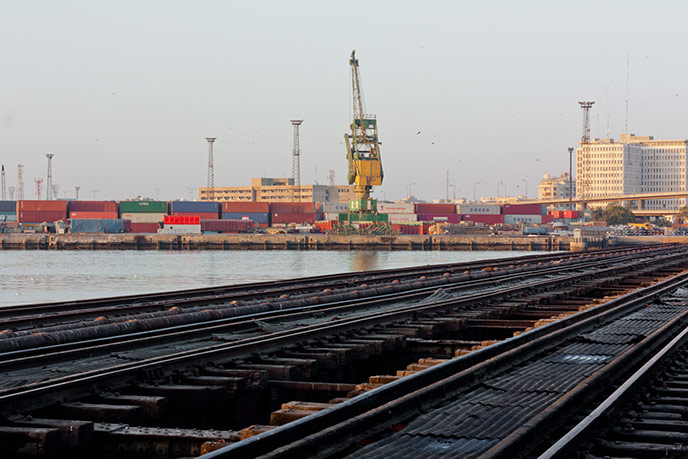
Railway (Karachi Port).
Calvo.- Are the demands of internal security preventing Pakistan from devoting enough funds and political attention to military modernization?
Waseem.- Military modernization is generally regarded not as falling within the domain of political actors but of the military. The Armed Forces appear to be devoting enough funds to military modernisation. Internal security operations take manpower away from the armed forces but their budgetary allocations come from different departments.
Calvo.- Are the Armed Forces, to the detriment of civilian police, seen by most citizens as the mainstay of security?
Waseem.- The general public appears to have bought into the narrative that armed forces are the only bodies capable of dealing with security issues. This is taking focus away from the police, especially in areas where armed forces have acquired policing powers of search and arrest. Nevertheless, there are voices on ground that call for the strengthening of police forces for internal security, law and order.
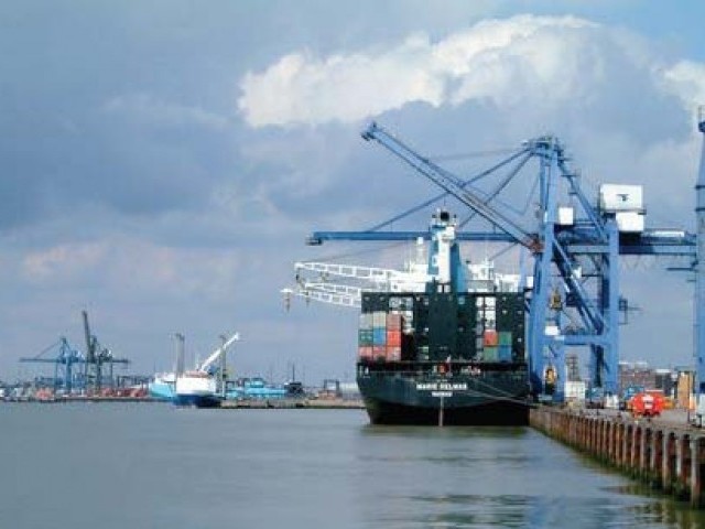
Karachi Port.
Calvo.- What are the prospects for police reform in the mid-term? What are its main aspects, and most significant obstacles?
Waseem.- There were police reforms in 2002 which were reversed in 2011 in Sindh and Balochistan. No serious initiatives appear to be in place at the moment. Main obstacles for this are: political interferences, weak leadership, and corruption. Policing falls under the domain of the provincial governments and there will be no serious reforms implemented till the will of these governments is not present.
Calvo.- Does Beijing trust Islamabad’s promises to severely prosecute groups assisting Xinjiang activists? What about guarantees of better protection of Chinese nationals in Pakistan?
I’m not sure what Beijing is thinking at the moment, but Pakistan seems to be making efforts to curb any apprehensions on their part. For instance, both the armed forces and civilian government has decided to strengthen security measures of the Chinese in Gwadar, Balochistan. Plans for deploying 10,000 army personnel for their security and deweaponisation of Gwadar are underway too. Much of the reason for the escalation in the internal security operation in Karachi is the China Pakistan Economic Corridor (CPEC).
Zoha Waseem got her LLB from SOAS (School of Oriental and African Studies) and her MA in Terrorism, Security and Society from King’s College London. She has studied in Karachi, Chicago, and Washington DC, and interned at different Pakistani news channels. From 2012 to 2013 she was an intern at Interpol’s Public Safety and Terrorism Sub-Directorate, in Lyon (France). She is currently working on her PhD thesis, at King’s College, on “Enforcement, Encounters and the Everyday: Contemporary Policing in Karachi, Pakistan”. Waseem’s research interests include Pakistan, policing and security, urban violence, counterterrorism, and police culture. She tweets at @ZohaWaseem and recently wrote “Darkness in the city of light” on Paris’ terror attacks.
After a long wait, the US Navy resumed FON (Freedom of Navigation) operations in the South China Sea (last carried out in 2012) on 27 October, with USS Lassen sailing within 12 nautical miles of Subi and Mischief Reefs, and conducting actions incompatible with innocent passage, in order to make it clear Washington does not recognize any territorial waters arising from the artificial islands built by Beijing through reclamation on low-tide elevations. On the other hand, in line with long-standing American policy, the US also emphasized that it was not taking sides concerning the underlying territorial disputes, and that freedom of navigation operations were aimed at any excessive maritime claims, underlining this by also sailing through waters around features claimed by Vietnam and the Philippines. Commentary has focused on the need for further FON cruises, and on China’s response, including the possibility of Beijing declaring an ADIZ (Air Defense Identification Zone).
Freedom of Navigation is indeed one of the pillars of both the post-war open economic system drawn up during the Second World War, and of the traditional American reliance on the ability to move troops by sea (in line with the British Empire, and its tandem Royal Navy – Indian Army). Therefore, contesting Chinese maritime claims is indeed an important policy goal, and furthermore one that should be shared by other maritime democracies. However, we must ask ourselves whether this is all. Furthermore, the time may have come to consider whether agnosticism on territorial claims is a sustainable policy, and whether the US can afford to see allies like the Philippines lose further territory to the PRC.
Even if FON operations become a regular feature and China’s extensive reclamationwork turns out to pose no obstacle to peace-time navigation by merchantmen and warships, we would be fooling ourselves if we thought that there is no price to pay for failing to confront Beijing. First of all, an extensive network of man-made islands could make it much more difficult to operate in the region in the event of hostilities. Second, by condoning the violent taking of contested territories, the principles enshrined in the UN charter and in UNSC Resolution 502 would risk becoming irrelevant.
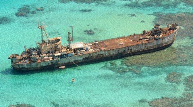
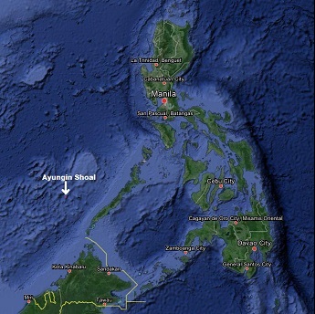
Concerning the latter, being neutral concerning territorial disputes can be interpreted in two ways. Up to now in the South China Sea it has meant Washington not supporting any competing claims. However, this is no longer enough. The Philippines’ marines have been making a heroic stand at BRP Sierra Madre, guarding Second Thomas Shoal (Ayungin Shoal / Ren’Ai Jiao) while surrounded by hostile ships bent on preventing their resupply. However, given the much larger forces available to China, this strategy may not be sustainable. Furthermore, despite an existing mutual defense treaty and growing capacity building assistance (also provided by Japan), Washington has de facto been signaling Beijing that the occupation of the Second Thomas Shoal would not be considered an attack on Filipino territory. This increases the risk of a miscalculation, should China come to believe that the US will stand on the sidelines in such an scenario. Mutual defense treaties are not of much use if restricted in their geographical scope.
An alternative policy would be to embed USMC personnel in their Filipino counterparts, while explicitly announcing that despite still not taking sides on the ultimate issue of sovereignty, the US considered the Second Thomas Shoal (and other disputed territories currently under actual control by Manila) to fall within the purview of the US-Philippines Mutual Defense Treaty. American policy would then be to actively seek to prevent changes on the ground, including expelling Filipino military personnel from the Second Thomas Shoal, while still pressing for a mediated (or arbitrated) solution, in line with US support for the international arbitration bid currently under consideration by the Permanent Court of Arbitration. Preserving the status quo requires extensive work on the BRP Sierra Madre, or its replacement by another ship or structure. In other words, America would be moving from passive neutrality to active neutrality. From merely declaring that differences must be settled peacefully in accordance to international law, to helping freeze the status quo so that revisionist powers are not tempted to gain in the field of battle what they should only be claiming in the diplomatic table or the courtroom.
A precedent for this are Japan’s Senkaku Islands, also claimed by China and Taiwan. After some doubts and conflicting reports on whether the US-Japan Security Treaty extended to them, Washington explicitly announced that they did, while remaining non-committal about ultimate sovereignty. Japan, having greater maritime and naval capabilities than the Philippines, employs a different strategy to protects the islands, shielded by the country’s coastguard without any permanent ground deployment. Should Tokyo decide, or be forced, to permanently deploy some ground troops, it would also be positive to see USMC personnel embedded in them. We could also mention the occupation of Iceland during the Second World War, before Pearl Harbor.
Being neutral in a territorial dispute does not just mean supporting its peaceful resolution in accordance with international law. That is only the case when all sides involved renounce the use of force. When one refuses to take this step, and regularly resorts to it, notwithstanding the fact it is mostly of the non-lethal kind, the only alternative to appeasement is active neutrality, meaning a deployment designed to provide a tripwire, lessening the risks of miscalculation and signaling that aggression will not be condoned. Only this can provide the necessary incentives for a future peaceful resolution of the conflict, where Washington would indeed be neutral concerning its outcome, yet having avoided neutrality regarding how it came about.
Alex Calvo is a guest professor at Nagoya University (Japan) focusing on security and defence policy, international law, and military history in the Indian-Pacific Ocean. Region. A member of the Center for International Maritime Security (CIMSEC) and Taiwan’s South China Sea Think-Tank, he is currently writing a book about Asia’s role and contribution to the Allied victory in the Great War. He tweets @Alex__Calvo and his work can be foundhere.
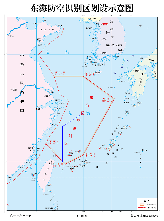
Two years ago on this day, the Ministry of National Defense of the People’s Republic of China issued a statement on establishing the East China Sea Air Defense Identification Zone. According to “the Statement by the Government of the People’s Republic of China on Establishing the East China Sea Air Defense Identification Zone,” three PRC domestic laws and administrative rules were addressed as the basis of the East China Sea ADIZ within the following text:
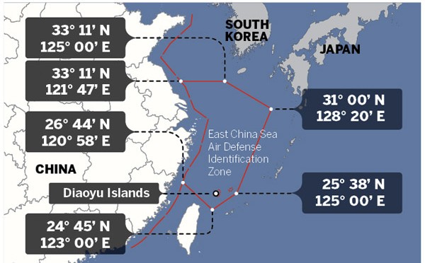
The government of the People’s Republic of China announces the establishment of the East China Sea Air Defense Identification Zone in accordance with the Law of the People’s Republic of China on National Defense (March 14, 1997), the Law of the People’s Republic of China on Civil Aviation (October 30, 1995) and the Basic Rules on Flight of the People’s Republic of China (July 27, 2001). The zone includes the airspace within the area enclosed by China’s outer limit of the territorial sea and the following six points: 33º11’N (North Latitude) and 121º47’E (East Longitude), 33º11’N and 125º00’E, 31º00’N and 128º20’E, 25º38’N and 125º00’E, 24º45’N and 123º00’E, 26º44’N and 120º58’E.
It is highly unlikely that the East China Sea ADIZ may effectively terminate all the foreign air reconnaissance maneuvers.
Further, based on this government statement, China’s Ministry of National Defense issued an announcement of the aircraft identification rules for the East China Sea Air Defense Identification Zone of the People’s Republic of China as the following text:
The Ministry of National Defense of the People’s Republic of China, in accordance with the Statement by the Government of the People’s Republic of China on Establishing the East China Sea Air Defense Identification Zone, now announces the Aircraft Identification Rules for the East China Sea Air Defense Identification Zone as follows:
First, aircraft flying in the East China Sea Air Defense Identification Zone must abide by these rules.
Second, aircraft flying in the East China Sea Air Defense Identification Zone must provide the following means of identification:
Flight plan identification. Aircraft flying in the East China Sea Air Defense Identification Zone should report the flight plans to the Ministry of Foreign Affairs of the People’s Republic of China or the Civil Aviation Administration of China.
Radio identification. Aircraft flying in the East China Sea Air Defense Identification Zone must maintain the two-way radio communications, and respond in a timely and accurate manner to the identification inquiries from the administrative organ of the East China Sea Air Defense Identification Zone or the unit authorized by the organ.
Transponder identification. Aircraft flying in the East China Sea Air Defense Identification Zone, if equipped with the secondary radar transponder, should keep the transponder working throughout the entire course.
Logo identification. Aircraft flying in the East China Sea Air Defense Identification Zone must clearly mark their nationalities and the logo of their registration identification in accordance with related international treaties.
Third, aircraft flying in the East China Sea Air Defense Identification Zone should follow the instructions of the administrative organ of the East China Sea Air Defense Identification Zone or the unit authorized by the organ. China’s armed forces will adopt defensive emergency measures to respond to aircraft that do not cooperate in the identification or refuse to follow the instructions.
Fourth, the Ministry of National Defense of the People’s Republic of China is the administrative organ of the East China Sea Air Defense Identification Zone.
Fifth, the Ministry of National Defense of the People’s Republic of China is responsible for the explanation of these rules.
Sixth, these rules will come into force at 10 a.m. November 23, 2013.
For the most part, military observers and political commentators have analyzed the matter from the political dimension. What is lacking is an examination of the validity of these three PRC domestic laws and rules as well as their association with the PRC government statement and the subsequent aircraft identification rules.
After reviewing the three laws and rules, i.e. the Law of the People’s Republic of China on National Defense, the Law of the People’s Republic of China on Civil Aviation and the Basic Rules on Flight of the People’s Republic of China, noted by the PRC East China Sea ADIZ statement (hereafter, the statement) and the associated aircraft identification rules, we may conclude the following flaws:
First, the effective dates of these three laws and rules noted by the statement are indeed questionable.
For the Law of the People’s Republic of China on National Defense, it was initially put into force on March 14, 1997, as noted by the statement. Likewise, the Law of the People’s Republic of China on Civil Aviation was originally put into effect on October 30, 1995, also noted by the statement. Nevertheless, according to the “Decision of the Standing Committee of the National People’s Congress on Amending Some Laws” issued by the Standing Committee of the National People’s Congress on August 27, 2009 and subsequently put into effect by the “Order No.18 of the President of the People’s Republic of China”, the Article 48 of the Law of the People’s Republic of China on National Defense was revised. Similarly, contents or wordings of the Article 191, 192, 193, 194, 195, 196, 197, 198, 199 and 200 of the Law of the People’s Republic of China on Civil Aviation were also revised by the same amending process and government document. Hence, the effective dates of these two laws noted by the statement were definitely incorrect after the law amendment process.
The original map attached to the PRC East China Sea ADIZ government statement.
Moreover, the Basic Rules on Flight of the People’s Republic of China was not initially put into force as noted by the statement. It was first jointly issued by the PRC State Council and the PRC Central Military Commission on July 24, 2000, by the “Decree No. 288 of the State Council of the People’s Republic of China and the Central Military Commission of the People’s Republic of China” after a large scale revision from its progenitor with the identical title established by the same two institutions on April 21, 1977.
Based on two separate documents but with the same titles known as the “Decision of the State Council and the Central Military Commission on Amending the General Flight Rules of the People’s Republic of China”, it was subsequently twice amended on July 27, 2001 and October 18, 2007. Also, the revised rules were put into force by the “Decree No. 312 of the State Council of the People’s Republic of China and the Central Military Commission of the People’s Republic of China” and “Decree No. 509 of the State Council of the People’s Republic of China and the Central Military Commission of the People’s Republic of China” on August 1, 2001 and November 22, 2007, accordingly. We therefore may notice that the effective date of the Basic Rules on Flight of the People’s Republic of China noted by the statement was neither the initial effective date of the rule nor the latest effective date of the rule.
Based on the survey results already mentioned , we may conclude that the validity and legality of the judiciary documents cited by the statement is undeniably questionable. The quality of this government statement is poor.
Second, the jurisdiction associated with the contents noted by these three laws and rules as compared with the airspace defined by the PRC East China Sea ADIZ can also be problematic. The jurisdiction defined by the Law of the People’s Republic of China on National Defense is basically illusive. It does note with the territorial airspace in its text. Yet, the substantial content of this law has never specifically mentioned its jurisdiction may extend to any air defense identification zone. Likewise, the Article 2 of the Law of the People’s Republic of China on Civil Aviation does declare the PRC’s exclusive sovereign rights over its territorial airspace. Many other articles of this law also repeatedly address its jurisdiction over the PRC territorial airspace. By the principle of ratione loci, we may clearly identify the jurisdiction defined by this law never was intended to extend to the airspace over the East China Sea.
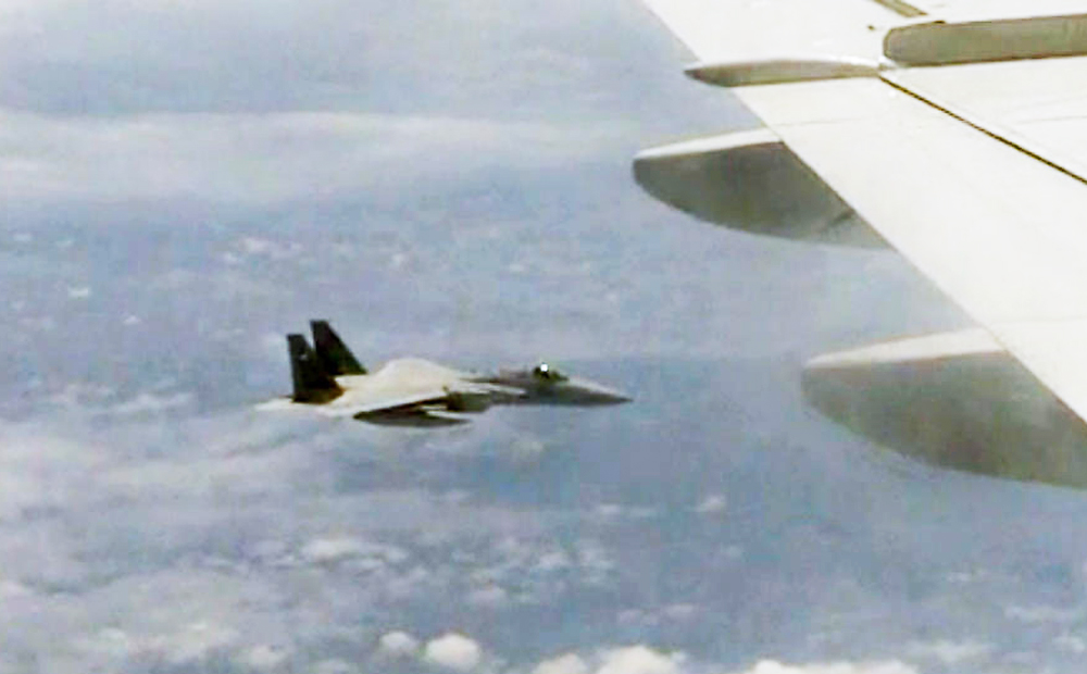
The PRC East China Sea ADIZ is not a hollow statement. The Substantial interception maneuvers toward the JMSDF MPA by the PLAAF fighters.
On the other hand, according to the Chapter 13 and the Article 173 of the People’s Republic of China on Civil Aviation, its jurisdiction does cover those foreign aircrafts or other flying objects within its territorial airspace. Also, by the terms noted in its Article 182, its jurisdiction may extend to certain search and rescue areas out of its territory. Nonetheless, such search and rescue areas are governed by the international treaties and totally irrelevant with any air defense identification zone.
Basically, the Basic Rules on Flight of the People’s Republic of China is the administrative rule originated from the People’s Republic of China on Civil Aviation. This is exactly the reason why the Article 1 of this rule specifically noted its jurisdiction only covering those aviation activities within the PRC’s territory. However, the Article 2 of the same rule also extends its jurisdiction over those units and persons with the ownership of the aircrafts as well as the personnel relevant to the aviation activities and the activities themselves. There are numerous articles of this rule repeatedly addressing its jurisdiction and objectives involved in the activities within this airspace as well as the aviation activities themselves.
The only exception regarding the jurisdiction out of its territorial airspace ever appeared in this rule is the Article 121 of Chapter XII titled with Supplementary Provisions: “In regard to the aircraft of the People’s Republic of China operating over the contiguous zones, exclusive economic zones or high seas beyond the territorial waters of the People’s Republic of China, where the provisions of an international treaty concluded or acceded to by the People’s Republic of China are different from the provisions of these Rules, the provisions of that international treaty shall apply, except the provisions for which reservation has been declared by the People’s Republic of China.” According to the content noted above, its jurisdiction may only cover the aircraft with the PRC nationality registration. It does not authorize any jurisdiction over foreign aircraft out of its territorial airspace.
After reviewing the content of these three laws and rules, we may very confidently believe that there is no basis of jurisdiction over the East China Sea ADIZ ever granted by them. This is another solid evidence of staff work negligence.
Third, terms or any substantial contents noted by these three laws and rules are never associated with the airspace defined by the statement or the aircraft identification rules requested by the PRC Defense Ministry announcement. The term of the ADIZ itself was never specifically defined by these three legal documents since it never ever appeared in any text of them. Further, for those means of identification demanded by the PRC Defense Ministry announcement, no corresponding regulation has ever been noted in these three laws and rules. Of course, Article 167 and 168 of the Law of the People’s Republic of China on Civil Aviation as well as Article 39 and 90 of the Basic Rules on Flight of the People’s Republic of China are noted with the term of flight plan, yet, the substantial content is totally irrelevant with the flight plan identification within the PRC East China Sea ADIZ.
As for the radio identification, the term does appear in the text of the Article 10, 88 and 90 of the Law of the People’s Republic of China on Civil Aviation for eight times and in the Article 48, 57, 60, 87, 95, 101 and 105 of the Basic Rules on Flight of the People’s Republic of China for a total of thirteen times. Again, the context of these applications is not relevant to the East China Sea ADIZ identification procedures. The term of secondary radar transponder noted by the transponder identification section of the PRC Defense Ministry announcement of identification rules is never noted in these three legal documents. Last but not least, for the logo identification, the term “logo” itself is mentioned by the Article 8, 58, 61 and 85 of the Law of the People’s Republic of China on Civil Aviation five times but the contexts are not substantially associated with the East China Sea ADIZ identification procedures.
Likewise, it was also noted by Article 24, 41 and 47 of the Basic Rules on Flight of the People’s Republic of China for six times. The content of the Article 24 and 47 is totally unrelated to the logo of any aircraft. Only the Article 41, “Aircraft operating within the territory of the People’s Republic of China shall bear distinct identification marks. Aircraft without identification marks are forbidden such flight. Aircraft without identification marks shall, when in need of such flight due to special circumstances, be subject to approval by the Air Force of the People’s Liberation Army. The identification marks of aircraft shall be subject to approval in accordance with the relevant provisions of the State,” the content is seemingly in accordance with the East China Sea ADIZ identification rule. Nonetheless, the jurisdiction of the Article 41 is only within the PRC territory, which is not the airspace defined by the East China Sea ADIZ.
It is noteworthy that there are various airspaces defined by these three laws and rules. Apart from the search and rescue areas mentioned above, the only other airspace that has the coverage out of the PRC territorial airspace is the “Flight Information Region” noted in the Article 30 and the Article 85 to Article 88 of the Basic Rules on Flight of the People’s Republic of China. The significance of the Flight Information Region is clearly defined by the International Civil Aviation Organization. It is totally different from ADIZ declared by any nation in the world. No confusion can happen between these two terms.
The PRC government statements on establishing the East China Sea Air Defense Identification Zone and the Defense Ministry announcement of the aircraft identification rules within this ADIZ are fundamentally reckless. The PRC East China Sea ADIZ has already existed for almost two years. Can we ask the following questions?
Does the PRC adopt this ADIZ to expand its sovereign claim as many political accusations ever predicted? Does this ADIZ successfully expand the PRC sphere of influence as many commentators ever actively speculated? Does this ADIZ pave the solid foundation for the PLA to exercise its airpower above the East China Sea as many military experts assessed? Do expanding PRC military air activities associate with the mechanism of this ADIZ? How much national pride is substantially acquired after establishing this ADIZ? Whether this ADIZ actually serves the functions as the PRC government originally claimed? And finally, do we fairly and comprehensively judge this issue by excluding our prejudice first?
All readers may have their own answer to these questions. We should never forget that the biased vision may only cause distortion of the fact and creating confusions that hindering us to see the reality. Whether we may fairly observe and assess the regime in Beijing does matter to our future strategic options and welfare.
Chang Ching is a Research Fellow with the Society for Strategic Studies, Republic of China. The views expressed in this article are his own.
Introduction. The Philippines’ South China Sea strategy brings together rearmament, rapprochement with the US, tighter security and defense links with Japan, and an international arbitration case under UNCLOS, whose fate is still pending, with oral hearings on jurisdiction having taken place over the summer. Manila’s narrative and legal arguments concerning Bajo de Masinloc (Scarborough Shoal) are grounded on post-World War II developments. On 18 April 2012 the Philippines’ Department of Foreign Affairs stated that “The Philippines considers Bajo de Masinloc an integral part of Philippine territory on the basis of continuous, peaceful and exclusive exercise of effective occupation and effective jurisdiction over the shoal”, stressing this was not based on UNCLOS but “anchored on other principles of public international law”, and also underlining that it “is not premised on the cession by Spain of the Philippine archipelago to the United States under the Treaty of Paris”. While, alternatively, the Philippines may seek to resort to historical arguments from earlier eras, this may play into China’s hands, as noted by some observers. The offer to Malaysia to downgrade Filipino claims on Sabah in exchange for moves reinforcing Manila’s position in the international arbitration case under UNCLOS seems to confirm that the Philippines have indeed decided to focus on post-WWII arguments.
Alternatively, Manila may have sought to follow one of three routes to prove the past exercise of sovereign powers as the foundation for her territorial claims in the South China Sea. The first possible line of argument would involve proving that the Spratly were part of the Spanish Philippines, and were transferred to the US after the 1898 war. The second would be to claim that they were incorporated into the Philippines following their transfer to American sovereignty. Finally, a third approach would be to argue that they were part of the Sultanate of Sulu, thus linking the two claims.
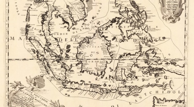
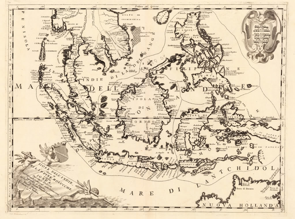
The Spanish colonial era. Three international conventions regulate the geographical extent of the territorial transfer following the 1898 war: the Treaties of Paris and Washington between the US and Spain, and that concluded between the United States and Great Britain on 2 January 1930. A range of potential problems would loom large if Manila tried to resort to the geographical extent of this territory. First of all, the mentioned treaties do not provide a fully detailed picture of the resulting borders. Second, the actual reach of the colonial administration was not always clear, with widespread resistance to Spanish rule and insurgency in a number of areas. In line with many other colonies, actual control was often a measure of distance from the capital, and went from long-standing exercise of sovereign powers, resulting in widespread cultural, linguistic, legal, economic, and social, influence, to little more than nominal sovereignty (or suzerainty when indirect rule was favored) on paper. Third, geographical knowledge was not always accurate, with some territories imperfectly mapped or chartered, and confusion sometimes arising out of conflicting accounts. Having said that, some maps, like the one below, do explicitly include features currently under dispute, such as Bajo de Masinloc (Scarborough Shoal).
“This map, from present-day Italy, included the Spratly in the Philippines’ territory”
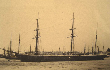
Furthermore, some expeditions and other activities took place featuring Bajo de Masinloc (Scarborough Shoal). After a long history of uncertainty over its existence and location, the grounding of HMS Scarborough, chartered by the East India Company to transport tea, on 12 September 1748 led not only to its modern English-language name, but to its precise chartering. Navigation charts published after the incident reflected it, but uncertainty still meant some debate on exactly where the ship had run aground, and some decades would pass until this was dispelled. It was the Malaspina Expedition which in May 1792 finally ascertained the exact location of Scarborough Shoal, and confirmed that some reefs appearing on maps actually referred to this feature. This was followed, in 1800, by the first detailed Spanish survey, conducted by the frigate Santa Lucia, part of the Cavite-based naval squadron. Commanded by Captain Francisco Riquelme, she was one of the first steam-powered warships deployed in the Philippine Islands to take part in the campaigns against the Sultan of Sulu and the Moro slave-raiding pirate bands. Thus, this ship illustrates two aspects of Spanish colonial rule which to some extent are contradictory, supporting and weakening potential historical arguments in line with Philippine claims. On the one hand, it illustrates the connection between the Philippines and Scarborough Shoal, with activities from Luzon-based ships. On the other, it reflects how conflict with insurgents and pirates were a constant of the period, with sovereignty on paper extending further than on the ground (and the waters).
Frigate Santa Lucia, which commanded by Captain Francisco Riquelme conducted the first Spanish survey of Scarborough Shoal (Bajo de Masinloc) in 1800
“This low-lying reef, per Riquelme, extends more than 8 2/3 miles from North to South, and 9 1/2 miles from East to West from one end to the middle part, but from there narrowing until it ends in a tip. It is surrounded by horrible dangers that may appear without warning or other markings to serve notice of their proximity. Some rocks can be seen slightly above water only by close observation on a clear day, and only by having careful look-outs can one see the reef at a distance of 7 miles”Capitan Riquelme’s findings were incorporated into the “Dorroteo del Archipielago Filipino”, the Spanish pilot’s guide. An 1879 edition reads:
Spanish colonial authorities did not only incorporate details of Scarborough Shoal into their charts, but also began to exercise search and rescue jurisdiction over the shoal, sending ships from Manila to assist vessels in distress. Since this is one of the activities traditionally considered to fall under the umbrella of exercise of sovereign powers, it is worth noting.
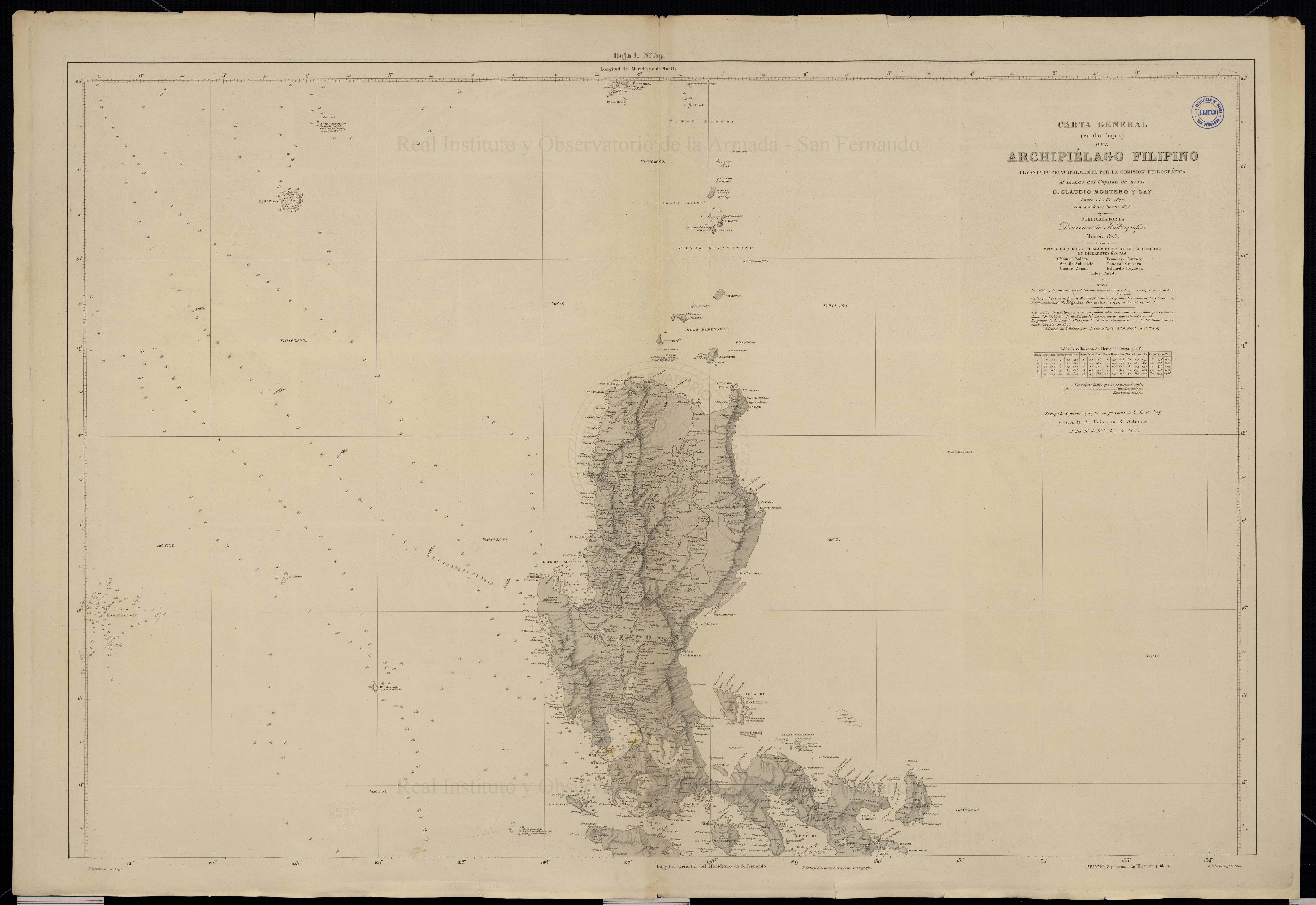
Eastern half of the General Chart of the Pacific Ocean, published in 1897 by the Hydrography Section of the Spanish Navy.Spanish colonial era map of the Philippines, including Bajo de Masinloc / Scarborough Shoal. Kindly provided by Dr David Manzano Cosano, Escuela de Estudios Hispano-Americanos (CSIC; Spanish National Research Council)
The Philippines under American sovereignty. A second possibility would be to argue that once under American sovereignty, currently disputed features clearly came to be officially considered part of Filipino territory. A significant obstacle to any such assertion is Washington’s long-held position that it takes no position on territorial disputes in the South China Sea, restricting its policy to how disputes are solved (insistence on peaceful solutions in accordance with international law) and the extent of any resulting settlement, with particular emphasis on freedom of navigation and overflight, and compliance with US views on the extent of coastal states powers in their EEZs. In December 2014 The Department of State published No 143 in its “Limits in the Seas” series, titled “China: Maritime Claims in the South China Sea”, which again emphasized that “The United States has repeatedly reaffirmed that it takes no position as to which country has sovereignty over the land features of the South China Sea”.
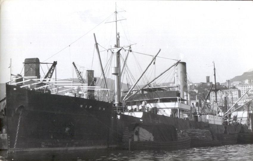
However, this view does not reflect the fact that the activities described earlier under Spanish colonial rule continued to take place after 1898. The most famous, and a well-documented, incident took place in 1913. A typhoon hit the S.S. Nippon, a Swedish steamer carrying copra, and she was wrecked on Scarborough shoal. This prompted Philippine authorities to intervene, together with private ships, in the rescue of the crew, investigate the accident, and carry out a scientific study on the effects of the sea on her cargo. In addition, the ship came under the salvage laws of the Philippines, and the resulting legal case was appealed all the way up to the Supreme Court of the Philippines, leaving behind an extensive paper trail documenting the exercise of a wide range of powers by the Philippine authorities in connection with Bajo de Masinloc (Scarborough Shoal).
The SS Nippon, owned by the Swedish East Asiatic Co., which shipwreck on Scarborough Shoal in 1913 led to a civil case that ended up before the Supreme Court of the Philippines
In the 1930s, the Commonwealth Government sought an explicit assertion of sovereignty over Scarborough Shoal, going beyond the exercise of administrative powers, including search and rescue. On December 6, 1937, Mr. Wayne Coy (Office of the US High Commissioner for the Philippines) asked Captain Thomas Maher (head of the US Coast and Geodetic Survey) whether any country had claimed Scarborough Shoal. The reply, dated 10 December 1937, was that no information was available on whether any nation had. Concerning the Santa Lucia 1800 survey, Captain Maher said “If this survey would confer title on Spain or be a recognition of sovereignty, or claim for same without protest, the reef would apparently be considered as part of Spanish territory the transfer of which would be governed by the treaty of November 7, 1900”. He also suggested that a new survey take place, and a navigational light be installed.
The next year saw Mr. Jorge B. Vargas (secretary to the president) write to Mr. Coy, asking about the status of Scarborough Shoal and saying that “The Commonwealth Government may desire to claim title thereto should there be no objection on the part of the United States Government to such action”. This prompted Mr Coy to forward this correspondence to the US War Department, which in turn sent them to the State Department, resulting in an interesting exchange. For example in a letter dated 27 July 1938 Secretary of State Cordell Hull told Secretary of War Harry Woodring that his department “has no information in regard to the ownership of the shoal”, which “appears outside the limits of the Philippine archipelago as described in Article III of the American-Spanish Treaty of Paris of December 10, 1898”. However, Hull wrote, “in the absence of a valid claim by any other government, the shoal should be regarded as included among the islands ceded to the United States by the American-Spanish treaty of November 7, 1900” and therefore the State Department would not object to the Commonwealth Government’s proposal to study the possible setting up of air and ocean navigation aids, as long as “the Navy Department and the Department of Commerce, which are interested in air and ocean navigation in the Far East, are informed and have expressed no objection”. The reply from Acting Secretary of the Navy W.R. Furlong to Acting Secretary of War Louis Johnson was positive, both concerning navigation aids and “the possibility of later claiming title”. The secretary of commerce also said his department had no objections.
We can observe a measure of ambiguity, though, with the US Government having no objections to the Commonwealth Government claiming Scarborough, and even considering it to be included in the second treaty with Spain following the 1898 War, but not actually claiming the features itself. Manila also expressed an interest in the Spratly, but despite this prompting Washington chose to keep a “low profile” concerning the archipelago, with non-recognition of claims by others and a close eye on Japanese interests and activities going hand in hand with a failure to officially claim the islands. The same applied could be said about Scarborough Shoal. In the words of François-Xavier Bonnet (IRASEC; Research Institute on Contemporary Southeast Asia), “the geographical proximity spoke in favor of the Philippines (rescue operations). In a way, Bajo de Masinloc could be seen as integrated in the sphere of influence of the Philippines, but outside the main archipelago. Political and symbolic acts, like naming the shoal, surveying, mapmaking, and organizing rescue operations, were the only appropriate activities that the Spanish and American authorities could do on an isolated shoal, which was, for the most part, underwater during high tide”.
The Sultanate of Sulu. A third possibility for Manila would be to claim sovereignty over Bajo de Masinloc as having historically been under the Sultanate of Sulu, that is merging the claim with that over Sabah. However the Philippines seem to be leaning towards focusing on Scarborough, going as far as offering Malysia to downgrade her claim to Sabah in exchange for support on the former conflict. This was clear in one of the Filipino moves this year connected to the international arbitration case, namely the offer to Malaysia, in a Note Verbale, to review its protest against the 6 May 2009 joint Vietnamese-Malaysian submission to the UN Commission on the Limits of the Continental Shelf (CLCS), containing a claim by Kuala Lampur of an extended continental shelf (350 nautical miles from the baselines) projected from Sabah. In exchange for this, Manila is requesting two actions that she believes would reinforce her case against China: First, to “confirm” that the Malay claim of an extended continental shelf is “entirely from the mainland coast of Malaysia, and not from any of the maritime features in the Spratly islands”. Second, to confirm that Malaysia “does not claim entitlement to maritime areas beyond 12 nautical miles from any of the maritime features in the Spratly islands it claims”.
The impact on Manila’s Sabah claims has not been lost on observers, with former Philippine permanent representative to the United Nations Lauro Baja Jr., if Malaysia explaining that if the deal is accepted the Philippines’ claim to Sabah will be “prejudiced”, adding that “We are in effect withdrawing our objection to Malaysia’s claim of ownership to Sabah”. Some voices argue that the Philippines need to stop claiming Sabah, since otherwise they are favoring Chinese claims to South China Sea features. William M. Esposo has criticized the “charlatans and overnight Sabah claim experts” who “thought they were patriots fighting for Philippine national interest” but “didn’t even realize that the arguments they were mouthing were supporting China’s very claims to our territory in the South China Sea”. Esposo cites Renato de Castro (De La Salle University International Studies Department), to stress that “historic claims, such as the one we have with Sabah, are the weakest cases when international courts decide territorial dispute”.
Conclusions. The Philippines are basing their South China Sea narrative on post-Second World War developments, and going as far as appearing ready to sacrifice their claim to Sabah in order to reinforce the arguments put forward in their international arbitration case against Beijing. This fits with Washington’s agnostic view of territorial claims, even when they involve areas formerly under US sovereignty. However, it is still interesting from a historical perspective to examine other possible arguments of this nature that could support Filipino claims on Bajo de Masinloc (Scarborough Shoal).
Alex Calvo is a guest professor at Nagoya University (Japan) focusing on security and defence policy, international law, and military history in the Indian-Pacific Ocean. Region. A member of the Center for International Maritime Security (CIMSEC) and Taiwan’s South China Sea Think-Tank, he is currently writing a book about Asia’s role and contribution to the Allied victory in the Great War. He tweets @Alex__Calvo and his work can be foundhere.