Category Archives: Territorial and Law of the Sea Disputes

United Nations Convention on the Law of the Sea, International Maritime Organization, and international maritime law.

Why There Is No ‘New Maritime Dispute’ Between Indonesia and China

This has been adapted from a blog post that first appeared on Strat.Buzz and was pulled from our friends at ASPI’s The Strategist.

In the last two weeks, there have been a number of articles circulating (including here, here, here and here) that Indonesia has formally recognised a territorial dispute with China in the South China Sea.

This discussion has originated from statements (see here, and here for example) attributed to Indonesian Navy Commodore Fahru Zaini, an assistant to the first deputy of the Coordinating Minister for Political, Legal, and Security Affairs (Menkopolhukam):

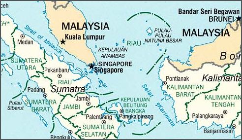
China has claimed Natuna waters as their territorial waters. This arbitrary claim is related to the dispute over Spratly and Paracel Islands between China and the Philippines. This dispute will have a large impact on the security of Natuna waters.

Commodore Zaini is also quoted as saying ‘…we have come to Natuna to see firsthand the strategic position of the TNI, especially in its ability, strength and its deployment of troops, just in case anything should happen in this region’.

Riau_sumatra_indonesiaThis might give the overall impression that Indonesia’s defence modernisation and deployment plans are driven by China’s recent assertiveness in the South China Sea, and that now Jakarta has officially staked out its policy to challenge Beijing.

This impression is false for several reasons.

First, officially, there’s no maritime ‘dispute’ between Indonesia and China. Following the statement by Commodore Zaini, Indonesian foreign ministry spokesman Michael Tene said that ‘Indonesia has no maritime border with China’ and that Indonesia isn’t a claimant state to the South China Sea dispute. Indeed, Foreign Minister Marty Natalegawa clarified further on March 19,

We have to be absolutely clear about this…There are three seemingly related but separate issues. Firstly, there is no territorial dispute between Indonesia and China, especially about the Natunas. In fact, we are cooperating with China in possibly bringing about foreign direct investment plans in the Natunas. Second, we are not a claimant state in the South China Sea. Third, on the nine-dash line, it is true that we do not accept that. This is why we have asked for a formal explanation from China regarding their claims’ legal basis and background.

This policy is of course not new. Jakarta lodged a complaint with the UN in 2010 regarding the nine-dash line. In fact, Indonesia has consistently argued for the importance of the Natunas and how it should handle the South China Sea since the mid-1990s. I’ve described Jakarta’s key interests in the Natunas elsewhere.

Daniel Novotny’s book also has a long list of quotations from various Indonesian policymakers since the 1990s that basically echoed Commodore Zaini’s sentiments: Indonesia is concerned that the Natunas and its EEZs could be endangered by China’s nine-dash line, but it will never officially admit a dispute with China because that would give credence to Beijing’s claims. Former Foreign Minister Ali Alatas perhaps said it best, ‘the repetition of an untruth will eventually make it appear as truth’.

We can debate the merits of this position, but ultimately, there’s no significant policy shift on the matter. I would add a caveat however that the status quo between China and Indonesia over the Natunas might remain until the day Beijing publicly challenges Indonesia’s rights to explore the natural resources within the Natunas and its EEZs.

Second, on the military build-up, the Natunas area has been a central feature in Indonesia’s external defence thinking since the 1990s. The largest ever tri-service military exercise under Suharto’s tenure in 1996 was based on a scenario in the Natuna islands. This has been the pattern for subsequent exercises since; though there’s an additional ‘Ambalat component’ to it recently.

The statements that the TNI leadership has been making lately about ‘flashpoint defense’ and how its latest military assets would be deployed in the Natunas should be taken with a grain of salt.

For one thing, the ‘flashpoint defense’ (and the role of the Natunas in it) and the military modernisation plans have been on the books since the mid-2000s and publicly described in 2010.

For another, the procurement of advanced platforms like the Sukhois and Leopard MBTs and others is part of the Minimum Essential Force (MEF) concept that has been around since mid-2000s. The MEF was designed less for a China threat and more for an organisational and technological revamp and to meet existing operational requirements. The urgency becomes salient when we consider that the TNI lost numerous men due to accidents and platform decay in the past decade.

Indonesia isn’t building up its military power against a resurgent China, but the current political climate does provide the TNI leadership with the opportunity to further push for their pre-existing plans and to deflect criticisms from civil society activists arguing against expensive weaponry.

Finally, we can speculate whether Commodore Zaini was speaking for the Indonesian government. The clarification from the Foreign Ministry, however, suggests he wasn’t. Does this mean Commodore Zaini was speaking for the TNI? One of my contacts close with the defence establishment in Jakarta suggests that wasn’t the case either. There haven’t been any significant changes or plans made regarding the Natunas and the South China Sea at TNI headquarters.

We should also consider the fact that the Coordinating Ministry for Political, Legal, and Security Affairs isn’t a decision making body like the Ministry of Defense. They coordinate policies, they don’t formally make them.

Why Commodore Zaini made the arguments isn’t clear. What is clear, I think, is: (1) he wasn’t authoritatively tasked with announcing a major policy shift (nor is there actually a policy shift), and (2) he was merely echoing long-held Indonesian policy sentiments.

For these reasons, I think the articles that have suggested an official policy change from Indonesia on the Natuna Islands and South China Sea may have taken things out of their proper context.

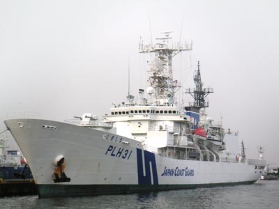
Evan A. Laksmana is currently a Fulbright Presidential PhD Scholar in political science with the Maxwell School of Citizenship and Public Affairs at Syracuse University. He is also a researcher with the Centre for Strategic and International Studies in Jakarta. Image courtesy of Wikipedia.

Sea Control 27 – International Law, Crimea, and China

seacontrolemblemProfessor Anthony Clark Arend joins us to discuss International law. We discuss some basic definitions, and their influence on international actors, using the lens of Crimea and the Chinese ADIZ. I also learn later that my mic input has been the crummy laptop mic all month, explaining all my audio quality frustrations. Remember, subscribe on iTunes or Stitcher Stream Radio. Leave a comment and five stars!

DOWNLOAD: Sea Control 27- International Law, China, and Crimea

The Chinese Coast Guard to Build World’s Largest Offshore Patrol Vessel – And More

Since its formation in 2013 by the consolidation of four previously independent agencies into a single entity (notably excluding the SAR agency), the Chinese Coast Guard has been experiencing phenomenal growth and has become China’s instrument of choice in its “small stick diplomacy” push to claim most of both the South China Sea and the East China Sea.
They commissioned two 4,000 cutters in January alone. It appears the growth will continue. The Wuchang Shipbuilding Industry Company has just been awarded a contract for four new 5,000 ton cutters, and China Ship-building Industry Corporation has been contracted to build two additional surveillance ships, one of 10,000 tons and another of 4,000-tons.
The US Coast Guard’s largest patrol cutters are the 418 foot, 4,500 ton full load Bertholf Class National Security Cutters. The illustration that accompanies the story of the four new 5,000 ton cutters shows a ship, in many ways similar to the National Security Cutter. It appears there is a medium caliber gun on the bow. (This would be a significant but not unexpected change for the Chinese Coast Guard.) There is a frame over what appears to be a stern ramp not unlike that on the NSC. The hull shape also appears similar to the NSC.
Japanese Coast Guard Cutter Shikishima, this class of two are currently the largest offshore patrol vessels in the world. Photo from Japanese Wikipedia; ja:ファイル:JapanCoastGuard Shikishima.jpg
Japanese Coast Guard Cutter Shikishima, this class of two are currently the largest offshore patrol vessels in the world. Photo from Japanese Wikipedia.

The “10,000 ton” cutter is likely to look similar to the Japanese Coast Guard’s two 492 foot, 9,350 full load, Shikishima class high endurance helicopter carrying cutters seen in the illustration above, but they may actually be much larger. Comparing their new ship to the Japanese cutters, the displacement of the Japanese ships was quoted as 6,500 tons, their light displacement. If the 10,000 tons quoted for the Chinese cutter is also light displacement, it could approach 15,000 tons full load. As reported here the new Chinese OPV will have a 76mm gun, two 30mm guns, facilities to support two Z-8 helicopters, and a top speed of 25 knots.

The size of the helicopters is notable. The Z-8 is a large, three engine, 13,000 kg helicopter based on the Aérospatiale SA 321 Super Frelon. The transport version of this helicopter can transport 38 fully equipped troops. The same airframe is also used for SAR, ASW, and vertical replenishment.
Undoubtedly the new vessels tonnage would give it an advantage in any sort of “shoving match” with vessels of other coast guards, but why so large?
The original justification for the Japanese cutters was to escort plutonium shipments between Japan and Europe, but the second cutter was built long after that operation was suspended, so clearly the Japanese saw a different justification for the second ship of the class.
Even so the Chinese ship may prove larger still. Other than prestige, why so large? China’s EEZ is small (877,019 sq km) compared to that of the US (11,351,000 sq km) or even Japan (4,479,358 sq km). Even adding the EEZ of Taiwan and other areas claimed by China, but disputed by others (3,000,000 sq km), the total is only about 3,877,019 sq km, and patrolling it does not require the long transits involved in patrolling the US or even the Japanese EEZ.
10,000 tons is about the size of a WWII attack transport, and with its potential to embark two large helicopters, China’s new large cutter could certainly exceeds the capability of WWII destroyer and destroyer escort based fast transports (APD). Using its helicopters and boats it could quickly land at least an infantry company, as could many of the smaller cutters. Chinese Coast Guard ships are already a common sight throughout the contested areas of the South China and East China Seas. Will Asia wake up some morning to learn there have been Chinese garrisons landed throughout the contested areas, by the now all too familiar Chinese Coast Guard Cutters.
Chuck Hill blogs at http://chuckhillscgblog.net/. He retired from the Coast Guard after 22 years service. Assignments included four ships, Rescue Coordination Center New Orleans, CG HQ, Fleet Training Group San Diego, Naval War College, and Maritime Defense Zone Pacific/Pacific Area Ops/Readiness/Plans. Along the way he became the first Coast Guard officer to complete the Tactical Action Officer (TAO) course and also completed the Naval Control of Shipping course. He has had a life long interest in naval ships and history.

Flashpoint: South Pacific – Vanuatu and New Caledonia

Islands

Who knew that France is still involved in a conflict over South Pacific maritime boundaries? Tell the French that their opponent in the conflict is Vanuatu and many will answer “What’s a Vanuatu?”

Few French even know that France claims one of the biggest aggregate maritime territories in the world. Indeed, due to its numerous overseas departments and territories, France possesses the second largest exclusive economic zone (EEZ) in the world, covering 11,035,000 km², just behind that of the United States, with 11,351,000km².

Shinzo Abe, the Japanese Prime Minister, even said in June 2013, that “France is a big maritime power,” and that France and Japan should collaborate for security issues in the Asia-Pacific region. Following up this sentiment, during Japanese Foreign Minister Fumio Kishida’s visit to Paris, the two nations agreed to closer military ties.

Funny enough, France is never mentioned in Australia’s Defence White Paper 2013. And yet Spain is, despite lacking any territory in the South Pacific. France on the other hand retains French Polynesia, Wallis and Futuna, and New Caledonia, a territory with an EEZ as big as South Africa’s.

One of New Caledonia’s neighbors, Vanuatu, then known as the New Hebrides, was a Franco-British Condominium (a territory with shared sovereignty) from 1906 to 1980. Nowhere else on earth were two colonial powers sharing an island. (Well, they of course first competed for it, before deciding to rule it jointly.)

While the former colony maintained formal relations with France after gaining independence, two little inhabited rocky islands known as Matthew and Hunter became the cause of a maritime boundary issue between the two nations.

In 1976, prior to Vanuatu’s/New Hebrides’ independence, France annexed Matthew and Hunter islands to New Caledonia rather than keep them in the New Hebrides condominium.
The Vanuatu government of the time rejected French sovereignty over the islands and planted the Vanuatu flag on Hunter Island in 1993 but a French patrol vessel prevented the party from reaching Matthew Island. France nowadays maintains a naval presence and an automated weather station on Matthew.

In 2009, the Vanuatu Prime Minister and the independence movement of New Caledonia, the FLNKS, signed a document – with no legal value – recognizing the Vanuatu sovereignty over Matthew and Hunter islands. This gesture is all the more surprising given that France has always stated that the two islands belong to the territory of New Caledonia, and that Vanuatu’s economy is largely supported by French development aid, as well as aid from Iceland, Australia, Japan, New Zealand, and others.

But in Vanuatu, the legends associated with these southern islands demonstrate the importance of these two islands in the Ni-Vanuatu (Vanuatu people) tradition. Matthew is known as the “House of the Gods” where the spirits of the dead go rest. Ni-Vanuatu speak of traveling regularly from the islands of the Vanuatu archipelago to Hunter and Matthew, singing and dancing when they were on one or the other of the two islands in dispute today. On the other hand, there is no known legend of these islands in New Caledonia.

Vanuatu claims that the two islands are part of its archipelago based on its offered geological and cartographic evidence. Those two islets are even being fought for before the UN under terms of the UN Convention on the Law of the Sea (UNCLOS)

The dispute spilled has also unsettled relations with neighbors. In 1982, for example, Fiji and New Caledonia signed an agreement on mutual recognition of their maritime boundaries, in which Fiji recognized French ownership of the Matthew and Hunter Islands. The action upset Vanuatu, which demanded that Fiji recognize Ni-Vanuatu sovereignty over the islands, stating that failure to do so would be a blow to peace in the region, but Fiji did not revoke its signature.
Oh, I almost forgot: Hunter Island is also unofficially claimed by the micronation Republic of Lostisland, which undertook an expedition to the island in July 2012. Lostisland is an international project generally classified as a micronation, with citizens from all over the world aiming to achieve the independence and sovereignty of the Hunter Island. But the likelihood of it impacting New Caledonian or Ni-Vanuatu claims is nil.

For all the fuss, the Matthew and Hunter Islands are two little volcanic islets that look pretty boring from above. See for yourself:

Nor are they big – Matthew is 0.1km² and Hunter 0.4km². So why are they so important for France? Is it because they are a sanctuary for the terns and playground for the studies of meteorologists and ornithologists? Of course not. France dreams of extending its sovereign rights over an additional 2,000,000km².

But it is serious business – at stake are the exploration and exploitation of hydrocarbons and rare metals, as well fishery resources. The exact resource contents of these areas will have to be determined by further scientific studies. It is clearly a bet for the future.

To take advantage of these potential riches, France filed extension requests for fourteen geographical areas with the Commission on the Limits of the Continental Shelf of the United Nations in 2009. A special French interdepartmental program (steering committee composed of seven departments) called Extraplac was created in 2002 to prepare for all potential expansion areas, without studying fisheries or mineral resources. Extraplac could also present common issues with other coastal states sharing the same continental shelf.

But the extension of the continental shelf would involve substantial financial resources to ensure the protection and control of the newly acquired areas, but the deep cut in the finances of the Ministry of Defense does not make this possible at the moment.
A final problem exists. Article 121 of UNCLOS states that “rocks which cannot sustain human habitation or economic life of their own, have no exclusive economic zone or continental shelf.” However, the story of the inhabited Clipperton islet in the North Pacific with its 431,015 km² big EEZ shows that France, like many, has a broad interpretation of the ability to sustain economic life.

At the same time, Article 47 of UNCLOS states that an archipelagic State may draw straight baselines “joining the outermost points of the outermost islands and drying reefs of the archipelago provided that within such baselines are included the main islands.” As such a state, if Vanuatu can also claim Matthew and Hunter islands as part of its territory and archipelago, it would be able to draw its baseline to the islands and thereby extend its EEZ from the islands without concern for Article 121.

It’s important to note that the Commission on the Limits of the Continental Shelf is charged with making recommendations to states, based on scientific evidence, on demarcating continental shelves (thereby conferring rights) when these shelves exceed the standard 200nm EEZ. However, it is up to the states themselves to enact the recommendations and settle the territorial claims.

Pretty interesting stuff happens in the South Pacific, huh?

Alix is a writer, researcher, and correspondent on the Asia-Pacific region for Marine Renewable Energy LTD. She previously served as a maritime policy advisor to the New Zealand Consul General in New Caledonia and as the French Navy’s Deputy Bureau Chief for State Action at Sea, New Caledonia Maritime Zone.