The following article is published in English and Chinese.
By Tommy Jamison
The present dispute over the South China Sea doesn’t hinge on fishing rights, or oil fields, or even military bases. At its root the controversy stems from conflicting, profoundly held and historically consistent “core interests/核心利益.” On the one hand, the United States sees freedom of navigation as a fundamental pillar of the post-war order and integral to the past 70 years of relative peace and prosperity. On the other, China’s (re)assertion of sovereignty over the South China Sea should be contextualized within its century long campaign to recover territory lost under (semi)-imperialism. The historical grounding of both these arguments seems lost on much of Washington as well as Beijing.
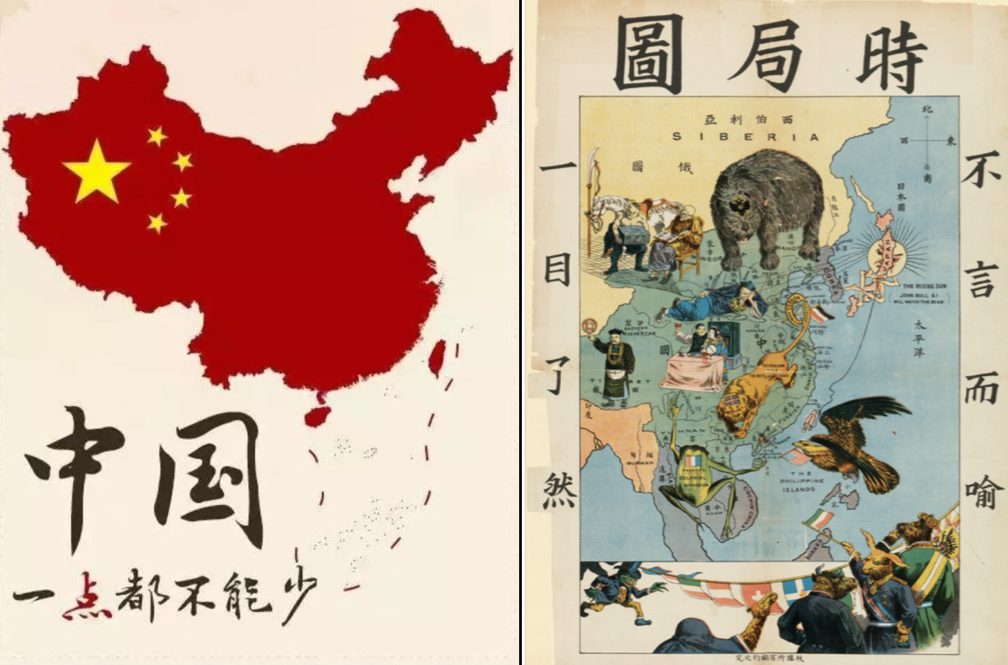
Left, “China: It Cannot Be Reduced by Even a Little.” Today a common image on social and state media (People’s Daily). Right, “A Map of the Current Situation” c. 1900. “It is obvious at a glance” that a host of imperial powers threatened Chinese sovereignty. (Wikipedia)
Territorial controversies are not new in China. From the Opium War (1839-42) to the present, resisting imperialism and recovering lost territory have constituted core objectives of Chinese foreign policy. As such, it is only through first exploring this historical context that we understand the modern conflict in the South China Sea. Because of “Western” (semi)-imperialism, territorial disputes in Chinese modern history are very common and have profound political ramifications. The question of Shandong’s sovereignty was the fuse for the May Fourth movement (1919); Japan’s aggression in Manchuria (1931) led to the collapse of the post-WWI internationalist system and incited the Second World War; before 1997 Hong Kong was one of the world’s last formal colonies; today Sino-Taiwanese relations remain a powder keg, and so on. From this historical perspective of course the South China Sea is a sensitive question. It is also in some ways a legacy of resistance to imperialism and, to a certain extent, a continuation of the 20th century movement to recover lost territories.
At the same time, from a macroscopic perspective, the U.S. post-war diplomatic strategy can be summarized in four principles: 1) defend democratic regimes; 2) encourage free trade; 3) protect freedom of navigation, because it is a fundamental requirement of free trade (alongside today freedom of information, the skies and even space); and 4) spread liberalization, an admittedly abstract principle. In short, the U.S. post war strategy has been an attempt to replace the pre-war anarchic international system with a liberal internationalist system. China’s activity in the South China Sea threatens these aims, particularly freedom of navigation, and thus threatens the post-war international system. Freedom of navigation is often criticized in mainstream Chinese media, as in, “At root, freedom of navigation is an excuse to implement the ‘pacific rebalance’ strategy and to contain the emergence of China,” but the present world was developed from these ideals. As such, freedom of navigation is in no way an empty slogan, but rather a core U.S. interest.
与此同时,在宏观层面上,美国二战后的外交战略可以归纳为四个原则:一是保护民主政府;二是推动自由贸易;三是捍卫航行自由,因为航行自由是贸易自由最基本的要求,现在这个原则扩展到飞行自由、信息自由,甚至天空自由等范围。第四个原则是最抽象的——普及自由化。简而言之,美国二战后的战略试图用自由国际秩序来代替二战前的无政府国际秩序(anarchic international system)。如今,中国在南海的行为威胁到了这些原则,特别是航行自由,因此也威胁到了二战后的国际秩序。中国主流媒体常常讽刺航行自由,比如“归根结底是借推行航行自由之名,行推进亚太再平衡战略、遏制中国崛起”等,但是目前的世界格局正在这理念之上发展而来。因此,航行自由绝非一个凭空的口号,而是一个核心利益。
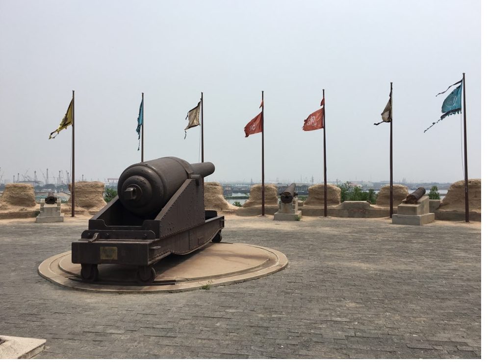
The Dagu Fort Memorial, Tianjin China (大沽口炮台纪念馆, 天津). It was built and modernized in the late nineteenth century in an effort to resist foreign amphibious attacks on Beijing. A sign helpfully notes that the memorial, “makes clear to subsequent generations: those who lag behind will be bullied, it is only through strength and prosperity that peace can be achieved.” 昭示后人:落后就要挨打,强盛才有安宁. (Author Photo)
None of this is to say that today’s South China Sea controversy is a direct continuation of China’s resistance to imperialism—far from it—but only to suggest that the conflict’s acuteness cannot be divorced from a larger historical context. When writing his history of Sino-U.S. relations from 1989-2001, David Lampton appropriated a saying about spousal conflict to sum up his findings: Same Bed, Different Dreams (同床异梦). That’s about right for the South China Sea as well. Still, the more worrying phrase might be the oft heard, “one mountain cannot hold two tigers” (一山,不容,二虎), which not coincidently frames the last chapter of Sarah Paine’s excellent history The Wars for Asia (1911-1949). Given the significance of historical context in this dispute, the potential for the misuse of history is likewise apparent. Eric Hobsbawm once wrote, “Historians are to nationalism what poppy-growers in Pakistan are to heroin-addicts: we supply the essential raw material for the market.” That danger seems particularly applicable to South China Sea where the trends of nationalism, hegemony, ecological scarcity and globalization intersect.
Still, one thing is for sure, giving serious thought to the historical background informing behavior on both sides of the Pacific would go a long way toward dispelling the distortions of modern day nationalists and bureaucrats alike. It might even help prevent an especially unnecessary war.
Tommy Jamison is a PhD Candidate in International History at Harvard University. He served as an officer in the U.S. Navy between 2009-2014.
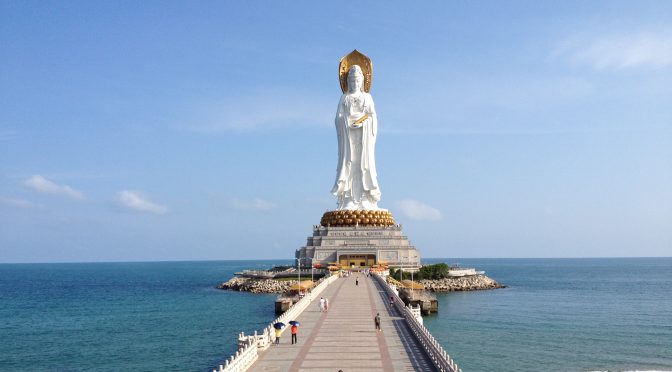
Featured Image: South China Sea Goddess of Mercy 南山海上观音圣像. (Percy)
As the South China Sea dispute continues to command headlines, such issues as China’s island building, U.S. Freedom of Navigation Operations (FONOPS), and the contested arbitration have received justified attention, but a concurrent trend in the activities of the PLA Navy (PLAN) in the South China Sea also merits closer consideration. Within the past several months, the PLAN’s South Sea Fleet (南海舰队) has engaged in relatively sophisticated anti-submarine warfare (ASW) drills (反潜作战演练). Historically, China has remained relatively weak in ASW and continues “to lack either a robust coastal or deep-water anti-submarine warfare capability,” according to the Department of Defense.1 Despite such persistent shortcomings, the apparent advances in the realism and complexity of these recent drills suggest that the PLAN’s ASW capabilities could be progressing. Given the context, these drills, which were reported upon in detail in official PLA media,2 might also have been intended as a signaling mechanism at a time of heightened regional tension. Presumably, the PLAN is also motivated by concerns about U.S. submarines operating in the region and the submarines procured by multiple Southeast Asian nations, including rival claimant Vietnam.
While China’s ongoing investments in ASW platforms have indicated an increased prioritization of improving its ASW capabilities, the PLAN’s ability to advance in this regard will also be influenced by its level of training and experience.3 Certainly, the levels of stealth and sophistication of current and future U.S. submarines will continue to pose a considerable challenge. Although the PLAN’s ASW capabilities will likely remain limited in the short term, its attempts to realize advances in ASW reflect a new aspect of its efforts to become a maritime power and attempt to achieve “command of the sea” (制海权) within the first island chain.4
Recent PLAN ASW Drills in the South China Sea
Between May 25th and 26th, the PLAN’s South Sea Fleet engaged in ASW drills that involved a confrontation between Red and Blue Forces that continued “successively for twenty-four hours uninterrupted.”5 After entering the South China Sea through the Bashi Channel, within the Luzon Strait between Taiwan and the Philippines, the far sea training formation involved initiated the drill “under actual combat conditions.”6 The Red Force involved four surface warships, two Type 052D guided-missile destroyers (Hefei and Guangzhou), a Type 052C destroyer (Lanzhou), and a Type 054A guided-missile frigate (Yulin), as well as three unspecified anti-submarine helicopters, against a Blue Force with an unknown number of submarines.
CNS Kunming (DDG-172) , the first of the Type 052D destroyers. (Photo: 海防先锋 via Wikipedia)
Since anti-submarine operations have reportedly become a “key emphasis” (重点) for the South Sea Fleet, this constituted an attempt to design a more advanced, realistic drill for ASW operations.7 It was characterized as “really rare” given the large size of the search area (1,000 square nautical miles); the multiple forms of anti-submarine forces included; the multiple ASW methods used, including five kinds of sonar; the employment of a greater number of anti-submarine attack weapons including anti-submarine rockets, depth charges, and torpedoes, and finally the length of the drill, which occurred for 24 hours continuously.8 That these aspects of the drill were considered so notable implies that prior drills were appreciably less sophisticated.
Although the drill seemed somewhat more advanced than previous such exercises, PLA media commentary also highlighted the existing shortcomings in the PLAN’s ASW capabilities that the drill was intended to mitigate. According to one PLAN officer who had participated, difficulties included the command and control over and coordination among the forces involved. He also highlighted that the two forces had not established a set program or plan prior to the drill – implying that past drills had been organized around more of a “script” (脚本).9 This lack of a script enabled the whole process to “break through into actual combat confrontation” and “explore anti-submarine methods and approaches.”10 In particular, this realistic training was intended to address certain “important difficulties,” including coordination between ships and aircraft, coordination of firepower, and information-sharing.11 For instance, a Blue Force submarine engaged in evasive measures, such that the Red Force had to cooperate closely and engage in real-time information sharing to locate it again and enable the launching of “precision strikes” against it.12
Although it is difficult to compare this ASW drill to previous iterations qualitatively or quantitatively – given the limitations of available information and uncertainties about the consistency of open-source reporting on such training – a review of prior accounts of the PLAN’s ASW exercises suggests that these drills have advanced considerably within the past several years. There seemingly has been a shift in the PLAN’s ASW training, starting from relatively routine exercises held only annually in the South China Sea, towards these more advanced exercises. In this regard, the South Sea Fleet’s engagement in this ASW drill at a time of heightened tension in the South China Sea not only might have been intended to serve as a signaling mechanism, but also may have reflected a longer-term trend toward advances in the PLAN’s ASW training. In the past several years, the PLAN’s ASW drills in the South China Sea have included the following:
September 2013: In accordance with the PLAN’s annual training plan, the East Sea Fleet held training exercises in the South China Sea that involved unspecified “new type” submarines, with collaboration between anti-submarine ships and anti-submarine helicopters, which reportedly “effectively increased ASW capability under informationized conditions.”13
September 2014: In accordance with the PLAN’s annual training plan, the East Sea Fleet held training exercises in the South China Sea in which there was an emphasis on “testing and exploring anti-submarine tactics.”14
May 2015: The Sino-Russian “Joint Sea” exercise incorporated an ASW component.15
November 2015: The North Sea, South Sea, and East Sea Fleets all engaged in live-fire “confrontation drills” in the South China Sea, involving Blue and Red Forces, which emphasized “information systems of systems ASW capability.”16, 17
January 2016: PLAN exercises with the Pakistan Navy incorporated ASW for the first time.18
May 2016: A sophisticated, realistic drill involving the South Sea Fleet occurred in the South China Sea, as described in detail above.19
July 2016: The PLAN’s extensive exercises in the South China Sea, which involved all three fleets, also included an ASW component.20, 21
While the list above is probably not comprehensive, this sequence seems to illustrate a potential shift in the pattern of the PLAN’s ASW training – or, at least, in official PLA media reporting on these drills. From late 2015 to the present, the reported drills have not occurred in accordance with the prior training schedule and have often involved the South Sea Fleet or multiple fleets. Perhaps this change indicates a shift in focus towards advancing the operational ASW capabilities of the South Sea Fleet in particular. As this timeframe has aligned with heightened regional tensions, the organization of such drills and the reporting on them could have indicated an increased degree of discomfort with the potential intensification of U.S. submarine activity in the South China Sea and also the ongoing procurement of Kilo-class submarines by rival claimant Vietnam, which received its fifth of six submarines in February 2016.22, 23 Eventually, this focus on realistic, unscripted ASW drills could enable the PLAN to progress in capitalizing upon the more advanced ASW platforms that have been concurrently introduced.
Ongoing Investments to Overcome Traditional Weaknesses in ASW
Although the PLAN’s ASW capabilities have historically been lacking, the increased frequency and sophistication of ASW drills have corresponded with investments in and the commissioning of new ASW platforms within the past several years. The PLAN previously had only the Ka-28 and the Z-9C as ASW helicopters, but has introduced the more sophisticated Changhe Z-18F ASW variant.24 Notably, the Y-8FQ Gaoxin-6, an anti-submarine patrol aircraft reportedly analogous to the P-3C, which has a lengthy magnetic anomaly detector, was introduced into the PLAN in 2015.25 Although it was not reported to have participated in recent exercises, the Gaoxin-6 could critically contribute to China’s future ASW capabilities. In June 2016, the PLAN’s South Sea Fleet also commissioned the Type 056A corvette Qujing, the tenth such vessel assigned to it, which reportedly has “good stealth performance” and has been upgraded with a towed array sonar for ASW.26, 27 As of 2016, a total of twenty-six Type 056 corvettes are in service throughout the PLAN, and there might eventually be sixty or more, likely including quite a few of this ASW variant.27
Type 056 corvette. (樱井千一 via Wikipedia)
Beyond these existing platforms, the PLAN has been investing in multiple aspects of its ASW capability that could have significant long-term dividends. According to one assessment, the construction of a helicopter base on reclaimed land on Duncan Island in the Paracels could constitute a component of a future network of helicopter bases that would enable the PLA’s ASW helicopters to operate more effectively in those contested waters.29 The PLA’s existing and future aircraft carriers could launch multiple anti-submarine aircraft, and less-authoritative Chinese media sources have emphasized the expected efficacy of a future Chinese carrier strike group in ASW.30, 31 Concurrently, China has been establishing an underwater system of ocean floor acoustic arrays in the near seas, referred to as the “Underwater Great Wall Project” by the China State Shipbuilding Corporation responsible for its construction.32, 33 In addition, the PLAN clearly recognizes the relevance of unmanned surface vehicles (USVs) and unmanned underwater vehicles (UUVs) in ASW. For instance, PLA academics from China’s National Defense University characterize “unmanned operations at sea” as among today’s “important development trends.”34 There are multiple Chinese USVs and UUVs under development,34 and PLA-affiliated individuals and institutes have evidently engaged in extensive research on the topic.36
Conclusion
Although the operational potential associated with such investments might require years to be actualized, China could eventually become a significant ASW force in the South China Sea and beyond. While the PLAN’s ability to engage effectively in ASW will likely remain limited by persistent shortcomings and its relative lack of experience for the short term, it is nonetheless notable that the PLAN has evidently decided to compete in an area of traditional U.S. advantage, which had previously seemed to be a lower priority for it. These apparent advances in its ASW drills and increased investment in a variety of ASW platforms could allow the PLAN to become an inconvenience and eventually an impediment to the ability of other regional players, and perhaps even U.S. submarines, to operate unchallenged in the South China Sea. Thus far, the PLAN appears to be focusing primarily on near seas ASW, especially with the “Underwater Great Wall,” and this concern regarding defense within the first island chain could reflect a reaction to the intensified U.S. focus on submarines as a tool to counter China’s A2/AD capabilities.37
This undersea dimension of strategic competition will likely continue to be a priority for the U.S. and China alike, and the South China Sea will remain of unique strategic importance. Notably, the majority of China’s submarines, including its SSBNs, is based on Hainan Island and would probably transit to the Pacific through the South China Sea.38 While the prevailing “undersea balance” seems unlikely to change significantly in the near future,39 the PLAN’s undersea warfare capabilities could advance more rapidly than anticipated across multiple dimensions. For instance, by one assessment, China’s new Type 093B SSN could be stealthier than expected.40 Looking forward, the traditional dynamics could also be appreciably altered by technological change. In particular, the U.S. and China’s parallel advances in unmanned systems, which will likely play a significant role in future undersea warfare, could accelerate competition in this domain. While visiting the USS John C. Stennis in the South China Sea, Secretary of Defense Carter alluded to the Pentagon’s investment in “new undersea drones in multiple sizes and diverse payloads that can, importantly, operate in shallow water, where manned submarines cannot,” which could become operational within the next several years.41 The PLAN’s USVs and UUVs might not be far behind. Although the PLAN may prove unable to overcome the U.S. Navy’s undersea dominance beyond the first island chain, the South China Sea itself could become a zone of “contested command” and frequent undersea friction in the years to come.42
Elsa Kania is a recent graduate of Harvard College and currently works as an analyst at Long Term Strategy Group.
Endnotes
1. Department of Defense, “Military and Security Developments Involving the People’s Republic of China 2016,” April 26, 2016, http://www.defense.gov/Portals/1/Documents/pubs/2016 China Military Power Report.pdf. For prior assessments of China’s relative weaknesses and gradual advances in anti-submarine warfare, see, for instance: Stratfor, “China: Closing the Gap in Anti-Submarine Warfare,” July 20, 2015.
2. See the PLA articles referenced later in the article, including: Li Youtao [黎友陶] and Dong Zhaohui [董兆辉], “The South Sea Fleet Organized Anti-Submarine Operations Drills [Which] Continued for 24 Hours Without Interruption” [南海舰队组织反潜作战演练连续24小时不间断].
3. For reflection on the importance of training and experience in ASW, see, for instance: Lt. Cmdr. Jeff W. Benson, USN, “A New Era in Anti-Submarine Warfare,” U.S. Naval Institute, August 27, 2014, https://news.usni.org/2014/08/27/opinion-new-era-anti-submarine-warfare.
4. The objective of becoming a “maritime power” was also articulated in China’s latest defense white paper. See: Ministry of National Defense of the People’s Republic of China[中华人民共和国国防部], “China’s Military Strategy” [中国的军事战略],” May 26, 2015.
5. Li Youtao [黎友陶] and Dong Zhaohui [董兆辉], “The South Sea Fleet Organized Anti-Submarine Operations Drills [Which] Continued for 24 Hours Without Interruption” [南海舰队组织反潜作战演练连续24小时不间断], China Military Online, May 26, 2016, http://www.81.cn/jwgz/2016-05/26/content_7073486.htm.
6. Ibid.
7. “The Strongest Lineup! The South Sea Fleet’s Five Large Primary Warships Through Day and Night [Engaged in] Joint Anti-Submarine [Operations]” [最强阵容!南海舰队五大主力战舰跨昼夜联合反潜], PLA Daily, May 27, 2016, http://news.xinhuanet.com/mil/2016-05/27/c_129019813.htm.
8. Li Youtao [黎友陶] and Dong Zhaohui [董兆辉], “The South Sea Fleet Organized Anti-Submarine Operations Drills [Which] Continued for 24 Hours Without Interruption” [南海舰队组织反潜作战演练连续24小时不间断], China Military Online, May 26, 2016, http://www.81.cn/jwgz/2016-05/26/content_7073486.htm.
9. Ibid.
10. “The Strongest Lineup! The South Sea Fleet’s Five Large Primary Warships Through Day and Night [Engaged in] Joint Anti-Submarine [Operations]” [最强阵容!南海舰队五大主力战舰跨昼夜联合反潜], PLA Daily, May 27, 2016, http://news.xinhuanet.com/mil/2016-05/27/c_129019813.htm.
11. Ibid.
12. Ibid.
13. “The East Sea Fleet’s South [China] Sea Drills Life-Fire Multiple New-Type War Mines, Successfully Destroying the Targets” [东海舰队南海演练实射多枚新型战雷成功摧毁目标], PLA Daily, September 26, 2013, http://mil.cnr.cn/jstp/201309/t20130926_513692312.html.
14. “The Navy’s East [China] Sea Fleet Organized Live-Fire Drills Under Complicated Acoustic Conditions” [海军东海舰队组织复杂水声环境下战雷实射演练], PLA Daily, September 26, 2014, http://news.xinhuanet.com/photo/2014-09/27/c_127040400.htm.
16. “Chinese navy conducts anti-submarine confrontation drill in South China Sea,” CCTV, November 20, 2015, http://220.181.168.86/NewJsp/news.jsp?fileId=327578.
17. The Navy Held Submarine-Aircraft Confrontation Drills in a Certain Maritime Space in the South China Sea” [海军在南海某海域举行潜舰机实兵对抗演练], China Youth Daily, November 21, 2015, http://news.sina.com.cn/c/2015-11-20/doc-ifxkwaxv2563788.shtml.
18. Koh Swee Lean Collin, “China and Pakistan Join Forces Under the Sea,” National Interest, January 7, 2016, http://nationalinterest.org/feature/china-pakistan-join-forces-under-the-sea-14829
19. Li Youtao [黎友陶] and Dong Zhaohui [董兆辉], “The South Sea Fleet Organized Anti-Submarine Operations Drills [Which] Continued for 24 Hours Without Interruption” [南海舰队组织反潜作战演练连续24小时不间断], China Military Online, May 26, 2016, http://www.81.cn/jwgz/2016-05/26/content_7073486.htm.
20. “The Three Large Fleets’ Realistic Confrontation,” [三大舰队实兵对抗], China Navy Online, July 14, 2016, http://jz.chinamil.com.cn/n2014/tp/content_7154202.htm.
21. Ibid.
22. “The Fifth Russian-Made Kilo Submarine [Has Been] Consigned to Vietnam” [第五艘俄制基洛级潜艇“托运”到越南], Xinhua, March 3, 2016, http://youth.chinamil.com.cn/view/2016-03/03/content_6907855.htm.
23. Minnie Chan, “China and US in silent fight for supremacy beneath waves of South China Sea,” South China Morning Post, July 8, 2016, http://www.scmp.com/news/china/diplomacy-defence/article/1985071/china-and-us-silent-fight-supremacy-beneath-waves-south.
24.“The Z-18 Anti-Submarine Helicopter [Has Been] Fitted With a New Radar [That] Can Attack Air-Independent Propulsion Submarines” [直18反潜直升机配新雷达 可攻击AIP潜艇], Sina, April 30, 2014, http://mil.news.sina.com.cn/2014-04-30/1712776972.html.
25.“Expert: “Gaoxin-6” improves China’s anti-submarine capability greatly,” China Military Online, July 10, 2015, http://eng.mod.gov.cn/Opinion/2015-07/10/content_4594293.htm.
26. “China commissions new missile frigate Qujing,” China Military Online, June 12, 2016, http://english.chinamil.com.cn/news-channels/china-military-news/2016-06/12/content_7096962.htm.
27. “A New-Type Corvette Has Been Officially Delivered to the Navy” [新型护卫舰正式交付海军],Ministry of National Defense Website, February 26, 2013, http://www.gov.cn/gzdt/2013-02/26/content_2340335.htm.
28. Department of Defense, “Military and Security Developments Involving the People’s Republic of China 2016,” April 26, 2016, http://www.defense.gov/Portals/1/Documents/pubs/2016 China Military Power Report.pdf.
29. Victor Robert Lee, “Satellite Images: China Manufactures Land at New Sites in the Paracel Islands,” The Diplomat, February 13, 2016, http://thediplomat.com/2016/02/satellite-images-china-manufactures-land-at-new-sites-in-the-paracel-islands/.
30. “The PLA Is Building an Effective Weapon in the South [China] Sea’s Seabed Against the American Military’s Submarines” [解放军针对美军潜艇在南海海底打造利器], Sina, June 18, 2016, http://mil.news.sina.com.cn/jssd/2016-06-18/doc-ifxtfrrc3844240.shtml.
31. “Our Aircraft Carrier Fitted with an Anti-Submarine Weapon [Will] Make American and Japanese Submarines Not Rashly Dare To Draw Near” [我航母配一反潜利器 使美日潜艇不敢轻易靠近], Sina, June 29, 2016, http://mil.news.sina.com.cn/jssd/2016-06-29/doc-ifxtsatm0986174.shtml.
32. Richard D. Fisher, “China proposes ‘Underwater Great Wall’ that could erode US, Russian submarine advantages,” IHS Jane’s Defence Weekly, May 17, 2016, http://www.janes.com/article/60388/china-proposes-underwater-great-wall-that-could-erode-us-russian-submarine-advantages.
33. See also: Lyle Goldstein and Shannon Knight, “Wired for Sound in the ‘Near Seas,’” U.S. Naval Institute Proceedings, April 2014, http://www.theguardian.pe.ca/media-ugc/items/2014-04-28-11-39-30-Goldstein&Knight%20-%20Wired%20for%20Sound%20in%20the%20Near%20Seas%20-%20Apr14.pdf.
34. Li Daguang [李大光] and Chan Jiang [姜灿], “Unmanned Surface Vehicles Have Become a Cutting-Edge Weapon for Future Maritime Warfare,” [无人艇成未来海上新锐武器], PLA Daily, February 12, 2014, http://military.china.com.cn/2014-02/12/content_31445672.htm.
35. Jeffrey Lin and P.W. Singer, “The Great Underwater Wall of Robots,” Eastern Arsenal, June 22, 2016, http://www.popsci.com/great-underwater-wall-robots-chinese-exhibit-shows-off-sea-drones.
36. For instance, Jiao Anlong [焦安龙],“An Exploration of Unmanned Anti-Submarine Warfare Platforms Under Informationized Conditions” [信息化条件下无人反潜作战平台探析], Science and Technology Horizons, (33), pp. 403-404, http://www.cqvip.com/qk/70356a/201333/48101887.html.
37. See, for instance: Megan Eckstein, “CNO Richardson: Navy Needs Distributed Force Of Networked Ships, Subs To Counter A2/AD Threat,” USNI News, March 11, 2016, https://news.usni.org/2016/03/11/cno-richardson-navy-needs-distributed-force-of-networked-ships-subs-to-counter-a2ad-threat.
38. For recent commentary on the topic, see, for instance: Minnie Chan, “South China Sea air strips’ main role is ‘to defend Hainan nuclear submarine base,’” South China Morning Post, July 23, 2016, http://www.scmp.com/news/china/diplomacydefence/article/1993754/southchinaseaairstripsmainroledefendhainan.
39. For a more detailed consideration of the undersea balance, see: Owen Cote, “Assessing the Undersea Balance Between the U.S. and China,” SSP Working Paper, February 2011.
40. Dave Majumdar, “Why the US Navy Should Fear China’s New 093B Nuclear Attack Submarine,” National Interest, June 27, 2016, http://nationalinterest.org/blog/thebuzz/whytheusnavyshouldfearchinasnew093bnuclearattack16741 .
41. Geoff Dyer, “U.S. to sail submarine drones in South China Sea,” Financial Times, April 18, http://www.cnbc.com/2016/04/18/us-to-sail-submarine-drones-in-south-china-sea.html.
42. This term is taken from: Bernard Brodie, A Layman’s Guide to Naval Strategy, Princeton University Press, Princeton, N.J.: 1942.
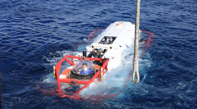
Featured Image: PACIFIC OCEAN (July 13, 2016) A sailor from the Chinese navy submarine rescue ship Changdao (867) sits in an LR-7 submersible undersea rescue vehicle off the coast of Hawaii following a successful mating evolution between the LR-7 and a U.S. faux-NATO rescue seat laid by USNS Safeguard (T-ARS-50), during Rim of the Pacific 2016. The evolution was the final event and practical portion of a multinational submarine rescue exercise between seven countries. (Chinese navy photo by Kaiqiang Li)
This article aims to provide a fair assessment of the military significance of the South China Sea land features. The term land feature is intentionally selected to avoid the trouble of arguing whether they are islands, reefs, shoals or rocks. How these land features can be categorized into the terms shown above may possibly cause differences according to the international regimes governing maritime jurisdictions, but not the military significance of the land features alone. Whether these land features may contain military value significant enough to be fought for are never decided by themselves. Other factors such as force, timing and additional characteristics associated with the space will fundamentally define their importance.
The space factor itself may only decide part of the operational conditions for any potential military campaign. Land features within the maritime theater should be assessed together with surrounding waters in the military geographical calculus. Hence, the land features, particularly within the maritime battlespace, are only a portion of geographical variables in the strategic and operational formulas for employing military forces. For the case of the South China Sea, the author would like to present the following points to remind strategic thinkers, political commentators, and military observers never to overstate, or even to overrate, the military significance of the land features in the South China Sea.
It is well proven by history that the land features in the South China Sea are fundamentally irrelevant with the generally perceived freedom of navigation, either in wartime or in relative peacetime. The United States Navy deployed submarine forces to target Japanese shipments in World War Two. Several engagements did occur in the South China Sea though no significant achievement was derived through these efforts.1 Nonetheless, it is pretty sure the land features had no influence on submarine blockade operations for either side.
Further, Operation Pocket Money launched by United States Navy Task Force 77 on May 9, 1972 during the Vietnam war for a naval mining mission was also irrelevant to those land features in the South China Sea, either.2 For these two obvious cases of paralyzing freedom of navigation around the South China Sea, those land features had no relevance within these operations. Only maritime assets, sometimes including air superiority, really mattered in operations aimed at hindering freedom of navigation.
Moreover, there are two maritime campaigns in the last half of the previous century specifically targeted on acquiring these land features. The first was the Battle of the Paracel Islands that occurred on January 19, 1974 between the naval forces of the People’s Republic of China and their maritime adversaries of the Republic of Vietnam Navy. It was originally a battle triggered by the effort of the South Vietnamese Navy to oust the Communist China’s naval vessels in the vicinity of the Paracel Islands. China successfully secured permanent control over the Crescent Group of the Paracel Islands after defeating Vietnamese maritime forces.
The second case was the 1988 Johnson South Reef Skirmish between the People’s Liberation Army Navy forces and the Socialist Republic of Vietnam Navy vessels. This naval battle took place over Johnson South Reef in the Spratly Islands on 14 March, 1988. China established its active presence around the Spratly Islands right after the decisive victory from a less than thirty-minute maritime engagement. By the end of 1988, China held six footholds on the land features in the Spratly Islands. The important lesson is that freedom of navigation in the South China Sea was never affected by these two naval campaigns specifically targeted on obtaining islands but fought with naval vessels to exclude adversary’s maritime presence around these land features.
From the two directions of logic reasoning shown above, the naval operations actually affected the freedom of navigation were irrelevant with the land features within the South China Sea. On the other hand, the naval campaigns for acquiring the land features within the South China Sea by expelling the adversary’s maritime presence around these land features were never relevant to the freedom of navigation, particularly, the maritime commercial transportation in the South China Sea. It only affected the maritime force within the surrounding waters of these land features. Why the territorial disputes fundamentally realized by the land features are so relevant to the freedom of navigation can be well perceived by measuring their locations subsequently introduced by the following second point.
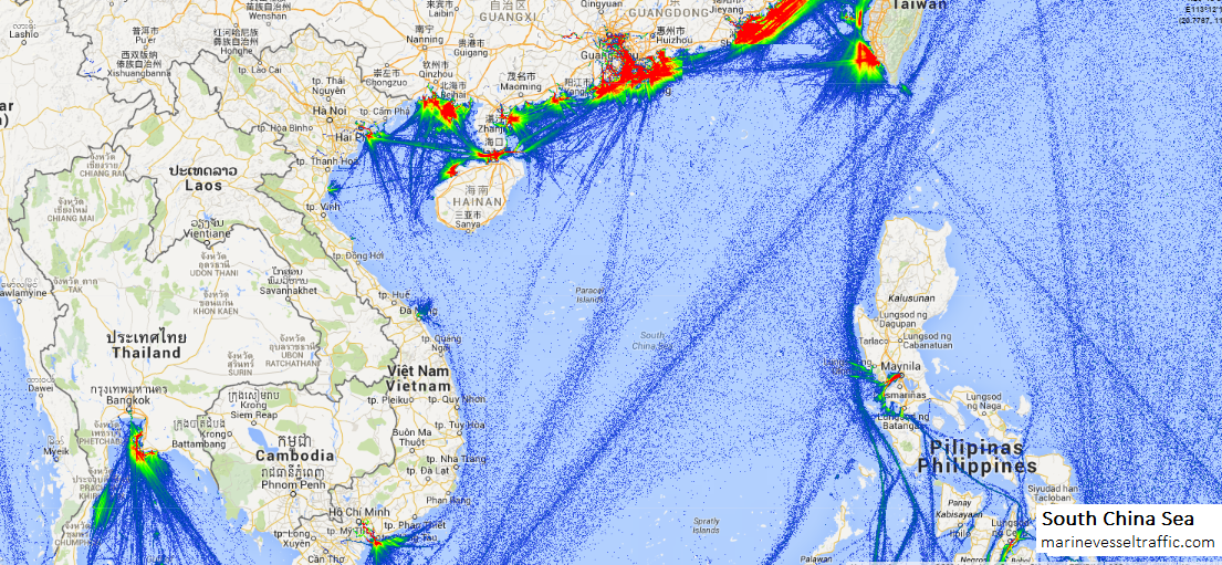
The locations of these land features are away from major sea lines of communication as shown by the picture below.
South China Sea vessel traffic map. (marinevesseltraffic.com)
We may therefore understand why these land features may not affect freedom of navigation since most maritime commercial transportation is quite distant from these disputed land features. Even land features that may be potential hot spots and could influence maritime campaigns to some extent are hardly a factor in hindering maritime transportation activities on a significant scale. In terms of a maritime campaign in the South China Sea, maritime platforms and air superiority really matter, not these land features.
Some may argue that land-based weapons such as anti-ship missiles may substantially hinder freedom of navigation. Again, the prerequisites of this engagement scenario are maritime transportation activities close enough to these land features. Certain military assets can exercise the sea control function, but never the land features themselves. Without the maritime reconnaissance supporting functions to match with the weapon systems, those land based anti-ship missiles are nothing but a fist with long reach but poor aim.
No one within the military chain of command dare shoot at any long range target at sea so blindly without achieving fully identification. Any case similar to the RMS Lusitania sunk by a German submarine on May 7, 1915 will present a nightmare to military and political decision makers.
W need to scrutinize the relative geographical locations of these land features. Basically, these land features are occupied by various parties and are all tangled together. For any individual land feature, regardless of its size and characteristics, it can only be defined as an isolated spot or foothold. Given the distances among these land features occupied by any single claimant in the South China Sea, it is impossible to form any meaningful defense. As no firepower from any other individual land feature may substantially cover the surrounding waters of other land features held by the friendly force units, the overall defensive posture is fragmented. No organized military operations seem feasible in the environment with the layout of land features as such. No meaningful military front or defensive zone can be possibly established in this operational space.
All the land features cannot mutually support each other all since the effective range of land-based firepower may not match with the distances between these land features. Without maritime surveillance capability, long range anti-ship missiles may not be operationally relevant in many engagement scenarios. Given the historical experience of the island hopping operational concept successfully employed in the Pacific theater in WWII, these land features can be easily bypassed because they cannot control any sea lane of communication. In other words, these land features can be ignored in any significant maritime campaign since they cannot form any organized military front or defense zone to support orchestrated military maneuvers.
It is reasonably expected that some may challenge this perspective with the recent developments and construction work occurring on these land features. It is undeniable that the capabilities of each land feature will be significantly enhanced after these improvements are completed. Accompanied with these enhanced capabilities, the logistical loads will also be increased. Although the strategic value of these land features would be seemingly increased, yet, the fundamental question remains the same: whether occupants of these land features may enact any meaningful military operations from these facilities including harbors, runways, berthing sites, and helicopter pads. Again, it will be decided by the distance between these land features and those frequently used maritime transportation routes. Enhancing military capabilities serving no substantial military tasks but only adding logistical burdens may make the land features a “strategic appendix” offering little utility but containing risk.
Last but not least, to answer the fundamental question of the military significance of the South China Sea land features, the question should be “what military operations in this maritime theater would rely on these land features?” Unquestionably, holding these land features may provide certain political leverage for claiming maritime jurisdiction upon adjacent waters. Nonetheless, fortification of these land features will not enhance existing positions on territorial claims, nor military significance for conducting potential operations. Facilities on these land features for supporting force employment and maritime surveillance will not be the most essential elements of any future military contingency within this maritime theater. Maritime assets will still be the core element. These land features can only serve a relatively minor role in a maritime campaign in the South China Sea as they always have in the past.
Chang Ching is a Research Fellow with the Society for Strategic Studies, Republic of China. The views expressed in this article are his own.
Endnotes
1. Heden, Karl E., Sunken Ships World War Two, Branden Books, 2006.
2. Mining of Haiphong Harbor, VietnamWar.net, http://www.vietnamwar.net/HaiphongHarbor.htm
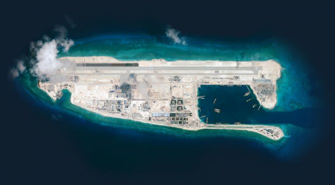
Featured Image: China’s new airstrip built over Fiery Cross Reef in the South China Sea (CSIS image)
Chinese leaders, like leaders elsewhere, rely on the advice of outside experts—academics and other professional scholars—to help them cope with the myriad challenges of international politics. Statesmen and scholars, however, come from very different worlds. When leaders craft foreign policy, they place a premium on secrecy. Scholars, by contrast, have powerful motives to share their views and tout their influence.
For those studying an opaque state like the People’s Republic of China (PRC), it is therefore very tempting to regard the “influential” Chinese scholar, who writes and speaks without reserve, as a proxy for the shy statesman he serves. The lure of this approach is especially strong in the case of the South China Sea, where authoritative—and reliable—statements of PRC intentions are particularly scarce. In the aftermath of the recent ruling of the Permanent Court of Arbitration (Case No. 2013-19), the writings of Chinese scholars will no doubt be closely scrutinized for insights about the PRC’s likely response to this desolating blow to its South China Sea claims.
But is this a wise approach?
We must immediately distinguish the advisor from the propagandist. Both have direct connections with the state. Indeed, an individual scholar may serve both functions. As a propagandist, the scholar justifies past and current policy; as an advisor, she seeks to shape future policy. Studying the work of the propagandist has merits: we learn what the PRC wants domestic and international audiences to believe. The statements of the advisor, however, are potentially much more rewarding, for they may suggest future actions. Knowing what a state may do allows one to engage in proactive diplomacy and prepare countermeasures.
Given the legal and strategic complexities of the issues at stake, Chinese scholars have an important advisory role to play in South China Sea policy. However, among the dozens (hundreds?) of Chinese scholars researching the law and politics of the South China Sea, the vast majority will never speak to or have their work read by men and women in positions of real authority. Thus, if one’s aim is to conjecture about the direction of PRC policy, the works of only a tiny number of Chinese scholars—i.e., those with demonstrable influence—are worth considering.
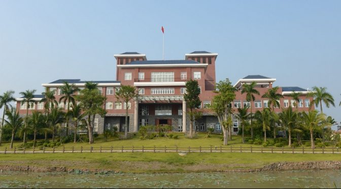
Researchers at the Hainan Center for South China Sea Policy and Law (海南省南海政策与法律研究中心) fall into this category. Examining this institute—and the work of one scholar in particular—allows us to explore what can and cannot be learned from the writings of “influential” Chinese scholars.
Established in December 2011, the Center is based at the Hainan University School of Law. Its mission is to “research the law of the South China Sea and serve national strategy.” It employs 17 full-time and 15 part-time researchers, all studying issues directly and indirectly related to China’s position in the South China Sea.
The Center is very closely connected to the Chinese government. Indeed, the chair of its academic committee is Gao Zhiguo, who directs a major research unit located within the State Oceanic Administration (SOA). Gao lectures widely on maritime issues, his audiences ranging from small communities of specialists to the most senior members of the Chinese party-state. In sum, the Center is a large, well-connected institute that exists to find answers to the most important questions facing Chinese policy in the South China Sea.
Like all academic institutions, the Center seeks to publicize the achievements of its resident experts. To this end, it posts detailed data about the research grants it receives. As of October 2015, the Center had been awarded dozens of grants totaling millions of RMB from entities such as the National Planning Office of Philosophy and Social Science (NPOPSS), the Ministry of Education, the Ministry of Justice, and the Hainan provincial government.
Such information is valuable in and of itself. Project names and grant amounts suggest which topics are important to the Chinese government. Since 2012, for example, Center researcher Wang Chongmin received half a million RMB (~$75,000) from SOA in order to do preliminary work on a “maritime basic law,” a comprehensive statement of China’s maritime claims and the roles and responsibilities of state entities charged with defending them. In 2015, Center researcher Chen Yangle was awarded 200,000 RMB (~$30,000) from NPOPSS to examine how China might promote tourism to the disputed Spratly Islands without undermining the “Maritime Silk Road” initiative, a policy aimed at cultivating regional good will. Since 2012, Chen Qiuyun received 50,000 RMB (~$7,500) from the Ministry of Justice to study how sailing directions (更路簿) supposedly handed down by generations of Chinese fishermen might bolster the legitimacy of PRC claims.
Center researcher Zou Ligang is a special case. From 2010-2012, NPOPSS awarded Zou a total of 120,000 RMB (~$18,000) to complete a project entitled “Research on Legal Issues Associated with the South China Sea Problem and a Program to Resolve It.” This bland title might be easily overlooked, were it not for the fact that NPOPSS appraised Zou’s work as “outstanding”—an honor the Center was eager to promote. Indeed, a closer examination of this project reveals a direct connection between Zou and the highest levels of the Chinese government.
As luck would have it, the Hainan Society of Social Sciences published a lengthy synopsis of Zou’s project. His overall objective was to probe China’s existing South China Sea policy and suggest improvements. One particular focus was the “nine-dashed line,” the undefined cartographical monstrosity that continues to confuse and dismay the coastal states of Southeast Asia. Zou proceeds from the assumption China has “jurisdiction” over all of the two million square kilometers of maritime space within the nine-dashed line. The purpose of his research was to create a legal basis for China to “control” (管控) these waters, and to do so without seriously harming regional stability.
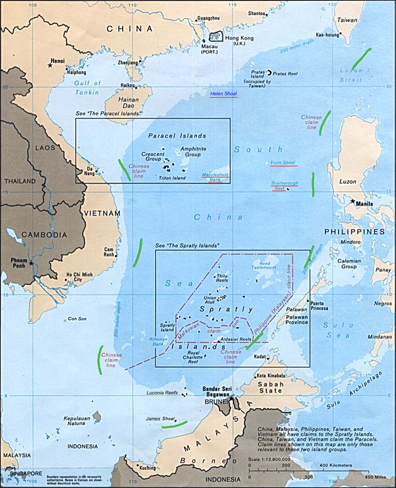
Map of claims in South China Sea (CIA/Wikipedia Commons)
The synopsis outlines Zou’s policy recommendations. Most reflect conventional thinking. For example, China should build and better coordinate its navy, coast guard, and maritime militia and leverage these capabilities in order to increase “routine administrative control” over Chinese-claimed waters. Zou also proposes that China revamp its domestic maritime law—again, a point that many other Chinese experts have been making for years. Other recommendations are less expected. These include taking steps to reduce the Chinese economy’s dependence on foreign powers and paying due regard to the interests of extra-regional powers (such as the U.S.) in the South China Sea.
The synopsis also sketches Zou’s conclusions about the “legal status” of the nine-dashed line. Zou admits that within China there exists no consensus on this question. However, since the UN Convention on the Law of the Sea (UNCLOS) is based on the principle that “the land dominates the sea,” Zou concludes that China’s maritime boundaries in the South China Sea should be largely determined by Chinese-claimed islands and other features. However, Zou asserts, this principle should not “impede China from claiming historic rights to certain specified waters within the nine-dashed line.” Taken together, Zou seems to be recommending that China use UNCLOS to claim as much space within the nine-dashed line as possible, and then use another argument based on “historic rights” to buttress Chinese claims to the remaining space.
If, as Zou suggests, offshore islands should largely determine China’s maritime rights in the South China Sea, the approach China adopts to draw baselines around these islands takes on tremendous importance. Zou has much to say on this topic. While China was correct to draw straight baselines around all of the Chinese-controlled Paracel Islands, this method would not work for the Spratlys because they are too widely dispersed. Thus, Zou recommends using the same approach that China applied to the Diaoyu/Senkaku Islands in the East China Sea. That is, China should draw baselines around different clusters of features within the archipelago, with zones of sovereignty and jurisdiction extending from them. The synopsis does not say which. However, in a 2013 journal article published under this grant number, Zou recommends that China center these clusters on Itu Aba (currently occupied by Taiwan), Thitu Island (the Philippines), West York Island (the Philippines), Spratly Island (Vietnam), and Mischief Reef (China).
Zou’s project was not funded for the sake of truth and knowledge. Its findings were intended to serve as a resource for policymakers. The synopsis states that, aside from journal articles like the one cited above, Zou also produced (or helped produce) 26 research reports for internal consumption. Among these reports, 10 were directly “adopted” by Hainan province, which administers all Chinese-claimed waters in the South China Sea (we do not learn which 10). Even more important, some of Zou’s reports landed on the desks of national Party officials. Three in fact were read and approved with comment (批示) by Xi Jinping and other members of the Politburo. The synopsis cites their titles: 1) “Views on Certain Issues Related to Maritime Law,” 2) “Legal Thinking with Respect to Resolving the Maritime Disputes,” and 3) “Strategic Research on Building the Maritime Silk Road.”
To sum up, we have learned that the Hainan Center for South China Sea Policy and Law is a major research institute producing policy-relevant analysis on the South China Sea for the direct benefit of the Chinese government at both the provincial and national levels. We know the names of individual projects and have the means to track down journal articles produced under specific grant numbers. In the particular case of Zou Ligang, we know that several of his reports were read and approved by the Politburo during a period of great flux in Chinese foreign policy. By reading articles published under this grant number, we can speculate about the advice Zou and his colleagues directly provided China’s most important decision makers.
We might ask, would knowledge of Zou’s proposals have enabled a foreign analyst to anticipate Chinese actions in the 2-3 years since they were submitted? That is, given Zou’s demonstrated advisory role on South China Sea issues, would it have been wise to regard his work as a portent of Chinese policy to come?
To be sure, China has pursued some of the policies recommended in Zou’s reports. It has invested heavily in its navy, coast guard, and militia. It has sought to enhance its control over claimed land and sea. In pushing forward with the drafting of a maritime basic law, it has taken steps to improve the maritime legal regime. However, these proposals reflect mainstream thinking in China. At most, then, Zou merely endorsed the existing consensus.
The legal status of the Spratly Islands, a much debated topic in China, is a more interesting test case. It is still too early to know for sure how China will draw baselines in the Spratlys. However, a recent article published in the PLA Daily under the byline of a research institute within the Central Party School suggests that China could ultimately settle on an approach that approximates Zou’s proposal. The article says that the “most likely and most appropriate” method for drawing baselines in the Spratlys is that used for the Diaoyu/Senkaku Islands. Such an approach, the article goes on, would center baselines around Itu Aba, Thitu Island, West York Island, Spratly Island, and Mischief Reef—the very same features recommended by Zou. If China does ultimately take this path, it is very possible that Zou Ligang will have played a significant role in this decision.
Still, one must acknowledge the limits of this approach. If one had relied on Zou’s work as a guide to future Chinese policy one would fail to foresee by far the most provocative Chinese action in recent memory: the conversion of tiny Spratly outposts into major military bases. Zou proposed policies that he believed would allow China to realize its aims without destabilizing the region. In choosing to construct new Spratly facilities, PRC leaders are plainly operating on an entirely different set of assumptions.
Thus, even when we are certain that a particular expert has the ear of Chinese leaders, we cannot know which proposals—if any—will ultimately be adopted. On any single issue, Chinese leaders no doubt consult a number of scholars. It is impossible to know whose ideas will have purchase. Moreover, outside academics are not the only source of ideas influencing Chinese policy. Experts employed directly by the state (and writing mostly or entirely for internal audiences) may convince Chinese leaders they have a better grasp of the issues at stake. Ultimately, facts and logic may not even be decisive: domestic politics or intangible factors like “national dignity” might trump expertise.
In conclusion, analyzing the work of “influential” Chinese scholars may help gauge the trajectory of Chinese policy in the South China Sea. This approach is bound to be most fruitful when the products of specific research projects can be directly linked to PRC decision makers. In such cases, policy recommendations may reflect actual policy options under consideration by those in positions of power. However, one must recognize that Chinese academics represent only one source of ideas. By fixating on the work of the scholars, we risk exaggerating their influence. Indeed, too much emphasis on this single source may go a long way to explain the failure of the American China studies community to foresee recent PRC actions—above all, the decision to build the new Spratly facilities that have so dramatically altered the regional balance of power.
Ryan D. Martinson is a researcher in the China Maritime Studies Institute at the U.S. Naval War College. The views expressed are those of the author and do not reflect the official policy or position of the U.S. Navy, Department of Defense or the U.S. Government.
Featured Image: National Institute for South China Sea Studies (NISCSS)