 As the Syrian conflict drags on well into its third year, military planners continue weighing the differing contingency options and courses of action. How do Turkey, Jordan, Iraq, Lebanon, Cyprus, and Israel protect themselves from a pre-emptive strike from the Baathist regime? Is Russia providing advanced weaponry to the regime? Will one or some of the various terrorist groups residing within Syria gain control of chemical weapons? What exactly is the Russian navy doing in the Eastern Mediterranean Sea? Who is the “opposition”?
The difficult limited choices (boots on the ground, non-fly zone, etc.) and the projection of future scenarios must be a heavy burden for military leadership that claim areas of responsibility for operations in Syria and around the Levant region. Yet, the common military (and political) dialogue fails to discuss a very real sequel to any military campaign in Syria – What will happen in Lebanon?
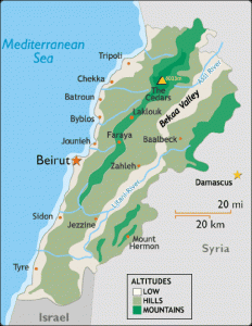
This “Switzerland of the Middle East” is a dynamic and aggravated area, susceptible to flare up and strife. Does it matter? To the Israelis: of course it does, just look at the recent history of operations in Lebanon. To the US: they have been involved in Lebanon (continually) since the early 1980s. The recognized border between Lebanon and Israel is a memorial to the frozen conflict of which is just pending Hizbollah and/or Syria’s next move.
In June 1941, the Allies conducted a Syria-Lebanon campaign (known as Operation Exporter) of which little is written. British, Palestinians, Jordanians, Indians, Australians, and the “Free French” conducted an invasion of Vichy-controlled Syria and Lebanon, ultimately resulting in a victory, with the Free French General Catroux being placed in charge of Syria-Lebanon. Shortly after, Catroux named both Syria and Lebanon free nations. Lebanon declared its independence in November 1943 with Syria claiming independence two months later.
In this campaign, Australian commandos as part of the British Layforce – an ad hoc assortment of special forces – conducted an amphibious raid into Lebanon through the southern Litani River area in an effort to seize key nodes (bridges and high terrain) in advance of the main force, driving north from Palestine towards Beirut. The amphibious force was to coordinate with the 21st Brigade’s attack on the Litani River position, through an amphibious assault from sea near the mouth of the river. They were to secure the north and south banks of the river and prevent an enemy demolition of the Qasmiye bridge, allowing the 21st brigade to advance towards Beirut. The landing force met unforeseen challenges posed both from their adversary as well as their own command and control. These likewise hold lessons for naval planners contemplating operations in the region today.
Limited Intelligence
The overall campaign commander, Field Marshal Henry Wilson, was unable to detail the force structure up to 10 days prior to the assault. There were limited amount of intel handbooks to provide information on Lebanese and Syrian roads, towns, people, and enemy forces. The allied forces only had broad maps (1:200,000) of the area of operations and no prior intelligence on beach landing sites. In response to this intel gap, action officers conducted a reconnaissance trip to Haifa to inquire on weather. Finding that the landing area had heavy surf at 300yds from the beach, and given the dates of the pending assault, a landing was not assessed as favorable.
While the information available to naval planners has grown in the last 70 years, given ISR limitations and a robust Syrian air-defense posture, limited actionable intelligence will most likely still present a challenge. Despite a recent Non-combatant Evacuation Operation (NEO) of Lebanon, the increased conflict in Syria and multi-national interest in the region pose a much more complicated environment and larger quantity of unknowns.
Conflicting Command Relationships
The senior officer of the amphibious force, consisting of the landing ship HMS Glengyle and destroyers HMS Hotspur, HMS Iris, and HMS Coventry, serving as escorts, delegated responsibility of landing boats to the commanding officer of the amphibious ship CAPT Petrie, RN. Upon conversing with the other ship captains (who all recommended against a landing) CAPT Petrie decided to recover the boats and return to Port Said. This decision was not concurred by Col Pedder, the Amphibious Landing Force commander, who argued that the risk was worth taking to maintain surprise (moonlight had showed their presence), but the decision was made to reverse course nonetheless. The ships returned to Port Said on the afternoon of 09 June, and after a brief meeting decided to get underway and attempt the landing again – early the next morning. The force returned at 0300 to the same spot (four miles west of the coast) and launched the operation under a full moon in calm weather. Various landing parties came under immediate fire upon arriving at the beach and many felt that the previous night’s loitering tipped off the enemy to their intentions. Additionally, when the main force (X) arrived south of the Litani River they observed that the enemy had already demolished the Qasmiye bridge.
While the decision to delay the landing had been delegated to CAPT Petrie, he also had a responsibility to report to his senior officer that landing force commander did not concur with the decision. Communication limitations may have hindered such a correspondence, but this hotly contested command relationship is another reminder of the inherent risks that are always involved in amphibious operations.
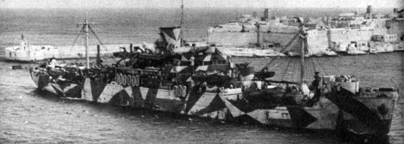
Naval history books are filled with command and control mistakes during amphibious operations and Allied forces in World War II learned hard lessons in their gradual development of effective amphibious task force/landing force relationships. Given the uniqueness of the Levant region and the Eastern Mediterranean there are multiple commands who may be involved. Recent western-coalition amphibious exercises (i.e. Bold Alligator) found persistent errors in command relationships and no common understanding of an appropriate chain of command. U.S. European Command (EUCOM), U.S. Central Command, and NATO all have operational area boundaries that meet in the Levant Region. Given the complexity of the area and environment, unless lessons of the past are understood, accepted, and acted upon the same issues may continue to haunt future amphibious operations in an around the Litani.
Faulty Navigation Skills
Two of the three landing parties (X and Z) had difficulties finding the correct landing site, resulting in the main effort (X party) landing one mile south of the intended objective and south of the Litani River, whereas the supporting effort (Z party) landed on the unintended side of the enemy forces. This is not the first early morning amphibious operation (see Gallipoli) in which the leading guide used an incorrect navigational aid (small house vice a bridge). Despite advances in GPS technology, the lack of updated environmental information and infrequent operations in this area should cause amphibious force planners to expect a comparable level of complexity.
Six minutes after landing, a battery of field guns including 75mm guns, 81mm mortars and heavy machine guns opened fire on X party’s beach. This may be viewed as irrelevant in light of today’s advanced equipment, but a friendly reminder that the 11 Scottish Commando’s arrival on the hillcrest overlooking the Litani river met with immediate friendly artillery fire should strike note of caution in maritime planners.
Lack of Air Support and Coastal Shore Bombardment
Vichy French recon planes made repeated flights over the landing forces, while their destroyers moved down the Lebanese coast, firing into landing parties positions. Despite ineffective shore bombardment on Z party, the X party sustained direct hits on troops and artillery with no effective friendly ship counter-fire. It is unfathomable to think that two enemy French destroyers were able to freely maneuver on the coast, disrupting landing force operations, while three allied destroyers and one cruiser were assigned as escorts.
This scenario easily translates to today’s operations and high-priority Ballistic Missile Defense platforms. In the Anti-Access / Area Denial (A2AD) environment (easily framed in the Eastern Mediterranean) planners should be asking more than just strategic imperatives and instead should be asking commanders for operational priorities. Who is the main effort? Who is supporting? In response to the Syrian conflict, will a Lebanon amphibious operation ever be the top priority or will naval forces be asked to conduct multi-functional missions that overlap C2 relationships, confuse capabilities and responsibilities, and fail to achieve mission success?
From a Naval perspective the Levant region is ripe with challenges: small maneuver space in the Eastern Mediterranean, only 3 choke-point entries (Gibraltar, Suez, Bosphorus), and a concave coastline that presents decreased distance from coastal-defense cruise missiles and coastal batteries, as well as, various territorial water space considerations. The amateur maritime planner may quickly consider these challenges as important for the status quo mission of maritime strike and ballistic missile defense, but with a bit more time invested a planner would quickly surmise that the Levant’s maritime domain is much more of a challenge for potential amphibious operations.
References: McHarg, Ian “Litani River.” United Kingdom, 2011. www.litaniriver.com
@NavalPlanner is an experienced strategic and operational military planner. He strives to share his perspective on operational art and planning with fellow maritime enthusiasts on his blog.

