Tag Archives: Nine-Dashed Line

US Department of State Seeks to Clarify Meaning of China’s 9-Dash Line Part 4

By Alex Calvo

This is the fourth installment in a five-part series summarizing and commenting the 5 December 2014 US Department of State “Limits in the Seas” issue explaining the different ways in which one may interpret Chinese maritime claims in the South China Sea. It is a long-standing US policy to try to get China to frame her maritime claims in terms of UNCLOS. Read part one, part two, part three

[otw_shortcode_button href=”https://cimsec.org/buying-cimsec-war-bonds/18115″ size=”medium” icon_position=”right” shape=”round” color_class=”otw-blue”]Donate to CIMSEC![/otw_shortcode_button]

3.- “Dashed Line as a Historic Claim”

The third way to see the dashed-line, according to the Limits in the Seas series paper, would be as a historic claim. Under UNCLOS this can take two forms, “one of sovereignty over the maritime space (‘historic waters’ or ‘historic title’)” or “some lesser set of rights (‘historic rights’) to the maritime space.” The paper devotes much more room to discussing this possibility than to the two previous alternative interpretations. It begins by pointing out that “some Chinese government statements and acts could be read to support a version of this historic claim interpretation”, and by noting that given that “the dashed-line maps pre-date the People’s Republic of China, the views of Taiwan are also of interest.” Concerning the Island’s claims, the text underlines that while in 1993 its “Policy Guidelines for the South China Sea” said that the dashed lines enclosed a “’historic water limit’ within which Taiwan ‘possesses all rights and interests’” (see K-H. Wang, “The ROC’s Maritime Claims and Practices with Special Reference to the South China Sea,” Ocean Development and International Law, Volume 41, 2010, pp. 237-252), Taipei has not stuck to this view. “Subsequent maritime legislation enacted by Taiwan and subsequent public statements, however, suggests that this view may no longer be officially held,” noted the State Department in another Limits on the Seas series issue, published in 2005, devoted to Taiwan. While the text refers to this 2005 paper, the latter’s contents do not discuss in depth ROC claims on the South China Sea, as clear from the fact that the term “South China Sea” only appears three times, whereas “dash” is not to be found. Thus, while the assertion that in studying PRC claims one should pay attention to ROC claims seems logical, this is not followed up, either in the 2005 Limits on the Issues paper devoted to Taiwan, or in the 2014 one dealing with China. In other words, the Department of State does not follow its own advice. How should we read this? On the one hand, the preeminent use of “Taiwan” may seem to amount to a limited recognition of political realities on the ground, in opposition to Beijing’s views, further contradicted by the scant regard for ROC practice as opposed to the PRC’s emphasis on administrative and international legal continuity with the Nationalist regime. An alternative, more Beijing-friendly, interpretation of the DOS approach may be that it is treating Taipei as the de facto authority on the Island, also for law of the sea purposes, while restricting its role in the South China Sea, where the PRC has consistently sought to exclude Taiwan from regional fora, in line with its traditional policy towards the Island. More generally, this may reflect the complex and ambiguous status of Taiwan, with neither the Island itself nor countries like the United States completely sure what it is. To add to the confusion concerning Taiwan in the DOS paper, it states on page 21 that “Many islands and other features in the South China Sea are occupied not just by China, but by … Taiwan,” yet again this is not followed by any detailed examination of Taipei’s claims.

Going back to evidence for the possible interpretation of Beijing’s claims as historic, the report cites as “most notable” China’s “1998 EEZ and continental shelf law, which states [in Article 14] without further elaboration that ‘[t]he provisions of this Act shall not affect the historical rights of the People’s Republic of China’” (emphasis added in the DOS report). China’s 2011 Note Verbale says that Beijing’s claims are supported by “historical and legal evidence,” but while the DOS report adds emphasis to “historical”, one should be careful not to confuse a historical claim with a claim supported by history. A country may put forward historical evidence in both negotiations and arbitration or adjudication in areas where UNCLOS refers to “equitable” solutions. The text also notes how many “Chinese institutions and commentators have considered that the dashed-line maps depict China’s historic title or historic rights.”

The DOS reports explains that “some” Chinese Government actions and statements which are “inconsistent with” UNCLOS, while not amounting to “express assertions of a historic claim, they may indicate that China considers that it has an alternative basis – such as historic title or historic rights – for its maritime claims in the South China Sea,” and provides some examples, such as the assertion by Foreign Ministry Spokesperson Qin Gang on 10 March 2014 that the Second Thomas Shoal (Ren’ai Reef) was under Chinese “sovereignty.” Qin Gang said “It is known to all that China has sovereignty over the Nansha Islands and their surrounding waters, including the Ren’ai Reef.” This mantra about sovereignty, together with repeated appeals to history, could indeed be considered as evidence that what Beijing has in mind is a historic claim. Furthermore, it may well be a claim going beyond the provisions for such term in UNCLOS. The report provides further evidence, beyond statements, to support the view that China may be making a historical claim. First of all, the “periodic oath-taking ceremonies at James Shoal” by Chinese naval vessels “to affirm ‘sovereignty’ over this bank” and the 2012 introduction by the China National Offshore Oil Corporation (CNNOC) of lease blocks in front of Vietnam’s central coast, in “waters under jurisdiction of the People’s Republic of China” according to the company yet with “portions of two of these blocks (BS16, DW04)” extending “without explanation to waters that are beyond 200 nm from any Chinese-claimed island.” The DOS report stresses that the resulting “assertion of maritime jurisdiction … exceeds what is provided for under” UNCLOS.

“Coat of arms of USS Lassen (DDG 82), which has conducted FONOPS in the South China Sea. Experts have criticized their ambiguity and are still debating their exact nature.”
Coat of arms of USS Lassen (DDG 82), which has conducted FONOPS in the South China Sea. Experts have criticized their ambiguity and are still debating their exact nature.

The idea that Chinese claims are “separate from, and additional to” UNCLOS is also suggested by domestic legislation, the DOS report notes. As an example it cites China’s 1999 Law on Marine Environmental Protection, which describes its geographical scope as extending to the country’s “internal waters, territorial sea, contiguous zone, exclusive economic zone, continental shelf of the People’s Republic of China and other sea areas under the jurisdiction of the People’s Republic of China” (emphasis in the DOS report). According to the text, UNCLOS is restricted to maritime zones mentioned in the law, and not to any “other sea areas under the jurisdiction” of the PRC, and “perhaps” this is a reference to “areas where China considers that it has historic claims.” Again, we must remember that this could be understood in two different ways, either China making a claim based on historic facts (recognized to a limited degree by UNCLOS) or China laying down sovereignty over certain areas of the sea based on principles and rules outside UNCLOS, or outside the prevailing interpretation of UNCLOS.

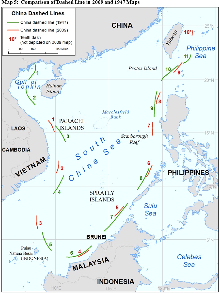
Has China made a historic claim? Next the DOS report examines two issues: whether China has actually “Made a Historic Claim”, and whether it would “have Validity.” Concerning the former, the text states that “China has not actually made a cognizable claim to either ‘historic waters’ or ‘historic rights,’” the reasons being a lack of “international notoriety” and the statement in her 1958 Territorial Sea Declaration that “high seas” separate the Chinese mainland and coastal islands from “all other islands belonging to China”. The text admits that the expression “historic waters” appears in some Chinese legislation and statements, and actually cites some of them, but believes that this does not amount to “notoriety” to a degree sufficient to “at the very least” allow “other states” to “have the opportunity to deny any acquiescence with the claim by protest etc.” (Taken from C.R. Symmons, Historic Waters in the Law of the Sea: A Modern Re-Appraisal, (Leiden: Martinus Nijhoff Publishers, 2008), p. 145) since “no Chinese law, declaration, proclamation, or other official statement” exists “describing and putting the international community on notice of a historic claim.” The text dismisses references to “historic rights” in the 1998 EEZ and continental shelf law as “a savings clause” and “not a statement of a claim itself.” An additional reason put forward by the text is that these could be references to “China’s sovereignty claim to the islands, and not the waters.” The 1947 map does not constitute either, according to the DOS report, a claim, and furthermore even if one had been made, the fact it was published domestically “in the Chinese language” would not amount to “an act of sufficient international notoriety to have properly alerted the international community.” More generally, the text considers that no subsequent Chinese map can be treated as having made a claim either, since they all “lack the precision, clarity, and consistency that could convey the nature and scope of a maritime claim” and cites in support of this view the ICJ “statement of principle” in the Frontier Dispute case between Burkina Faso and Mali, which says that “Whether in frontier delimitations or international territorial conflicts, maps merely constitute information which varies in accuracy from case to case; of themselves, and by virtue solely of their existence, they cannot constitute a territorial title, that is, a document endowed by international law with intrinsic legal force for the purpose of establishing territorial rights.”

Read the next installment here

Alex Calvo is a guest professor at Nagoya University (Japan) focusing on security and defence policy, international law, and military history in the Indian-Pacific Ocean. Region. A member of the Center for International Maritime Security (CIMSEC) and Taiwan’s South China Sea Think-Tank, he is currently writing a book about Asia’s role and contribution to the Allied victory in the Great War. He tweets @Alex__Calvo and his work can be found here.

[otw_shortcode_button href=”https://cimsec.org/buying-cimsec-war-bonds/18115″ size=”medium” icon_position=”right” shape=”round” color_class=”otw-blue”]Donate to CIMSEC![/otw_shortcode_button]

US Department of State Seeks to Clarify Meaning of China’s 9-Dash Line Part 3

By Alex Calvo

This is the third installment in a five-part series summarizing and commenting the 5 December 2014 US Department of State “Limits in the Seas” issue explaining the different ways in which one may interpret Chinese maritime claims in the South China Sea. It is a long-standing US policy to try to get China to frame her maritime claims in terms of UNCLOS. Read part one, part two

[otw_shortcode_button href=”https://cimsec.org/buying-cimsec-war-bonds/18115″ size=”medium” icon_position=”right” shape=”round” color_class=”otw-blue”]Donate to CIMSEC![/otw_shortcode_button]

Let us move to the three interpretations put forward by the US Department of State.

1.- “Dashed Line as Claim to Islands”

This would mean that all Beijing was claiming were the islands within the dashed lines, and that any resulting maritime spaces would be restricted to those recognized under UNCLOS and arising from Chinese sovereignty over these islands. The text notes that “It is not unusual to draw lines at sea on a map as an efficient and practical means to identify a group of islands”. In support of this interpretation one could take the map attached to the 2009 Notes Verbales and the accompanying text, which reads “China has indisputable sovereignty over the islands in the South China Sea and the adjacent waters, and enjoys sovereign rights and jurisdiction over the relevant waters as well as the seabed and subsoil thereof (see attached map)”. The text notes that the references in the paragraph above to “sovereignty” over “adjacent” waters” may be interpreted as referring to a 12-nm belt of territorial sea, since international law recognizes territorial waters as being a sovereignty zone. In a similar vein, references to “sovereign rights and jurisdiction”, “relevant waters”, and “seabed and subsoil thereof”, would then be taken to concern the legal regime of the EEZ and the continental shelf, as defined by UNCLOS.

As possible evidence for this interpretation, the study cites some Chinese legislation, cartography, and statements. The former includes Article 2 of the 1992 territorial sea law, which claims a 12-nm territorial sea belt around the “Dongsha [Pratas] Islands, Xisha [Paracel] Islands, Nansha (Spratly) Islands and other islands that belong to the People’s Republic of China”. This article reads “The PRC’s territorial sea refers to the waters adjacent to its territorial land. The PRC’s territorial land includes the mainland and its offshore islands, Taiwan and the various affiliated islands including Diaoyu Island, Penghu Islands, Dongsha Islands, Xisha Islands, Nansha (Spratly) Islands and other islands that belong to the People’s Republic of China. The PRC’s internal waters refer to the waters along the baseline of the territorial sea facing the land”. The Department of State also stresses that China’s 2011 Note Verbale states that “China’s Nansha Islands is fully entitled to Territorial Sea, Exclusive Economic Zone (EEZ), and Continental Shelf”, without laying down any other maritime claim. Concerning cartography, the study cites as an example the title of “the original 1930s dashed-line map, on which subsequent dashed-line maps were based”, which reads, “Map of the Chinese Islands in the South China Sea” (emphasis in the DOS study). With regard to Chinese statements, the study cites the country’s 1958 declaration on her territorial sea, which reads “and all other islands belonging to China which are separated from the mainland and its coastal islands by the high seas” (emphasis in the DOS study). The text argues that this reference to “high seas” means that China could not be claiming the entirety of the South China Sea, since should that have been the case there would have been no international waters between the Chinese mainland and her different islands in the region. This is a conclusion with which it is difficult to disagree, although we should not forget that it was 1958, with China having barely more than a coastal force rather than the present growing navy. Therefore, while the study’s conclusion seems correct, and precedent is indeed important in international law, it is also common to see countries change their stance as their relative power and capabilities evolve. Thus, if China had declared the whole of the South China Sea to be her national territory in 1958 this would have amounted to little more than wishful thinking, given among others the soon to expand US naval presence in the region and extensive basing arrangements. Now, 50 years later, with China developing a blue water navy, and the regional balance of power having evolved despite the US retaining a significant presence, Beijing can harbor greater ambitions.

6
Then US Secretary of State Hillary Clinton with her Filipino counterpart, Albert del Rosario, in June 2011. Washington supports Manila’s arbitration bid and rearmament, but takes no official position on her territorial claims, despite involving former American territory.

This section ends with the DOS study stating that should this interpretation be correct, then “the maritime claims provided for in China’s domestic laws could generally be interpreted to be consistent with the international law of the sea”. This is subject to two caveats, territorial claims by other coastal states over these islands, and Chinese ambiguity concerning the nature of certain geographical features, Beijing not having “clarified which features in the South China Sea it considers to be ‘islands’ (or, alternatively, submerged features) and also which, if any, ‘islands’ it considers to be ‘rocks’ that are not entitled to an EEZ or a continental shelf under paragraph 3 of Article 121 of the LOS Convention”. Some of these features, Scarborough Reef for example, are part of the arbitration proceedings initiated by the Philippines.

2.- “Dashed Line as a National Boundary”

This would mean that Beijing’s intention with the dashed line was to “indicate a national boundary between China and neighboring States”. As supporting evidence for this interpretation, the DOS report explains that “modern Chinese maps and atlases use a boundary symbol to depict the dashed line in the South China Sea”, adding that “the symbology on Chinese maps for land boundaries is the same as the symbology used for the dashes”. Map legends translate boundary symbols as “either ‘national boundary’ or ‘international boundary’ (国界, romanized as guojie)”. Chinese maps also employ “another boundary symbol, which is translated as ‘undefined’ national or international boundary (未定国界, weiding guojie)” but this is never employed for the dashed line.

The report stresses that, under international law, maritime boundaries must be laid down “by agreement (or judicial decision) between neighboring States”, unilateral determination not being acceptable. The text also notes that the “dashes also lack other important hallmarks of a maritime boundary, such as a published list of geographic coordinates and a continuous, unbroken line that separates the maritime space of two countries”. The latter is indeed a noteworthy point, since border lines would indeed seem to need to be continuous by their very nature, rather than just be made up of a number of dashes. This is one of the aspects making it difficult to fit Beijing’s claims with existing categories in the law of the sea. In addition, the report notes that they cannot be a limit to Chinese territorial waters, since they extend beyond 12 nautical miles, and neither can they be a claim to an EEZ, since “dashes 2, 3, and 8” are “beyond 200 nm from any Chinese-claimed land feature”. These last two aspects also make it difficult to see the dashed line as marking one of the categories recognized by UNCLOS. Moving beyond the law, however, and this is something that the DOS report does not address, a certain degree of ambiguity may be seen as beneficial by a state seeking to gradually secure a given maritime territory. Some voices have noted this may have been the US calculus in the San Francisco Treaty. Thus, the technical faults, from an international legal perspective, in China’s dotted line are not necessarily an obstacle to Beijing’s claims, from a practical perspective.

Read the next installment here

Alex Calvo is a guest professor at Nagoya University (Japan) focusing on security and defence policy, international law, and military history in the Indian-Pacific Ocean. Region. A member of the Center for International Maritime Security (CIMSEC) and Taiwan’s South China Sea Think-Tank, he is currently writing a book about Asia’s role and contribution to the Allied victory in the Great War. He tweets @Alex__Calvo and his work can be found here.

[otw_shortcode_button href=”https://cimsec.org/buying-cimsec-war-bonds/18115″ size=”medium” icon_position=”right” shape=”round” color_class=”otw-blue”]Donate to CIMSEC![/otw_shortcode_button]

China’s Nine-Dashed Line Faces Renewed Assault

By Scott Cheney-Peters

China’s ambiguous claim to the South China Sea, approximately demarcated by a series of hash marks known as the “nine-dashed line,” faced objections from an expanding number of parties over the past two weeks. While a challenge from the United States came from an unsurprising source, actions by Indonesia and Vietnam were unexpected in their tone and timing.

8-e48b8c470eOn December 5th, the U.S. State Department released its analysis of the compatibility of China’s nine-dashed line with international law. The report attempted to set aside the issue of sovereignty and explore “several possible interpretations of the dashed-line claim and the extent to which those interpretations are consistent with the international law of the sea.” The analysis found that as a demarcation of claims to land features within the line and their conferred maritime territory, the least expansive interpretation, the claim is consistent with international law but reiterated that ultimate sovereignty is subject to resolution with the other claimants.

As a national boundary, the report went on, the line “would not have a proper legal basis under the law of the sea,” due to its unilateral nature and its inconsistent distance from land features that could confer maritime territory. Alternately, although many commentators have indicated China bases its claims on “historic” rights pre-dating the UN Convention on the Law of the Sea (UNCLOS) of 1982, the report argued that the history China points to does not fit the narrow “category of historic claims recognized” in UNCLOS under which historic rights may be conferred. Lastly, the report noted that as China has filed no formal claim supporting its nine-dashed line, the ambiguity over the exact nature and location of the line itself undermines under international law China’s argument that it possesses maritime rights to the circumscribed waters, concluding:

“For these reasons, unless China clarifies that the dashed-line claim reflects only a claim to islands within that line and any maritime zones that are generated from those land features in accordance with the international law of the sea, as reflected in the LOS Convention, its dashed-line claim does not accord with the international law of the sea.”

Although such analysis reflects prior U.S. policy positions, less expected were the pointed signals from Indonesia, which has built a reputation as a mediator among ASEAN states in dealing with China and striven to downplay the overlap by the nine-dashed line of its own claimed exclusive economic zone in the South China Sea from Natuna Island. On Tuesday at the think tank Center for Strategic and International Studies (CSIS) in Washington, senior Indonesian presidential advisor Luhut Binsar Panjaitan emphasized that the country was “very firm” that its “sovereignty cannot be negotiated,” while stressing the importance of dialogue to peacefully manage matters. Further, in response to a question from an audience member, Panjaitan stated (56:00 mark in the video below) that the development of gas fields offshore Natuna in cooperation with Chevron would “give a signal to China, ‘you cannot play a game here because of the presence of the U.S.’” Meanwhile Indonesian Maritime Affairs and Fisheries Minister Susi Pudjiastuti noted that after sinking Vietnamese vessels the Indonesian Navy said it had captured illegally fishing she was considering sinking 5 Thai and 22 Chinese vessels also caught.

As Prashanth Parameswaran notes at The Diplomat, Indonesia is playing a balancing act – seeking at the same time to protect its sovereign interests as it attempts to align new president Joko Widodo (Jokowi)’s “Maritime Axis”/“Maritime Fulcrum” initiative with Xi Jinping’s “Maritime Silk Road” and play a leading role in China’s Asian Infrastructure Investment Bank. To some observers, sinking the Thai and Chinese boats is now necessary to preserve Indonesia’s image of impartiality, while others believe such action may be redundant if China heeds the warning that such behavior will no longer be tolerated.

Vietnam too took surprise action over the nine-dashed line, in a move long-mooted but unexpected in its timing. Vietnam’s foreign ministry announced last week that it had filed papers with the Hague arbitral tribunal overseeing the case submitted by the Philippines, asking that its rights and interests be considered in the ruling. Vietnam supported the Philippines position arguing that China’s nine-dashed line is “without legal basis.” While a regional source in The South China Morning Post noted that the action was as much about protecting “Vietnamese interests vis-à-vis the Philippines as it is directed against China,” and Professor Carlyle Thayer described it as “a cheap way of getting into the back door without joining the Philippines’ case,” Thayer also told Bloomberg News that it “raises the stature of the case in the eyes of the arbitrational tribunal.”

China-Vietnam-RigIf the actions taken by the United States, Indonesia, and Vietnam were surprising, China’s reactions were not. On December 7th, China’s Ministry of Foreign Affairs released a white paper of its own on the Philippines’ arbitration case. The document states that China’s policy, as established in its 2006 statement on UNCLOS ratification, is to exclude maritime delimitation from compulsory arbitration. Additionally, the paper says that while the current arbitration is ostensibly about the compatibility of China’s nine-dashed line with international law, “the essence of the subject-matter” deals with a mater of maritime delimitation and territorial sovereignty. The paper goes on to say that until the matter of sovereignty of the land features in the South China Sea is conclusively settled it is impossible to determine the extent to which China’s claims exceed international law.

In effect, China is taking the position that only after it has conducted and conclude bilateral sovereignty negotiations will its nine-dashed line be open to critique. While the foreign ministry may be right that the Philippines is attempting to force the issue of territorial sovereignty, its argument that this prevents scrutiny of the nine-dashed line’s accordance with international law rings hollow.

At the end of the day, China has repeatedly stated, and its new policy paper affirms, that it will “neither accept nor participate in the arbitration” initiated by the Philippines. Chinese Foreign Ministry Spokesman Hong Lei likewise remarked of Vietnam’s filing with the tribunal that “China will never accept such a claim.” So it is prudent to ask what benefit will come of the legal maneuvers. Some, such as Richard Javad Heydarian, a political-science professor at De La Salle University, point to the economic harm already incurred by the Philippines in opportunity costs and the danger of having created a worse domestic and international environment for settling the disputes. Yet given the lengthening list of states willing to stake a legal position on the matter and the moral weight of a potential court ruling, China can claim and attempt to enforce what it wants, but it will be increasingly clear that it is doing so in contravention of international law.

Scott Cheney-Peters is a surface warfare officer in the U.S. Navy Reserve and the former editor of Surface Warfare magazine. He is the founder and president of the Center for International Maritime Security (CIMSEC), a graduate of Georgetown University and the U.S. Naval War College, and a member of the Truman National Security Project’s Defense Council.

Sea Control 34, Asia-Pacific: Game-Changers

seacontrol2This week, Sea Control Asia Pacific looks at ‘gamechangers’ in Asia. Natalie Sambhi, of the Australian Strategic Policy Institute, interviews her colleagues Dr Rod Lyon and Daniel Grant about the ways in which Asia Pacific states are engaged in strategic competition. We also offer an Australian perspective on domestic political changes and military modernization in Southeast Asia, China’s nine-dash line claims, Indonesia and non-alignment, and the US rebalanced.

DOWNLOAD – Sea Control 34: Asian Game Changers

Remember, subscribe on iTunes or Stitcher Stream Radio. Leave a comment and five stars!