Tag Archives: UNCLOS

South China Sea arbitration: Beijing puts forward her own views Part Two

By Alex Calvo

This is the second installment in a four-part series devoted to China’s 7 December 2014 document, putting forward her views on the Philippines’ international arbitration case on the South China Sea. Although Beijing is refusing to take part in the proceedings, as confirmed following the Court’s 29 October 2015 ruling on jurisdiction, by issuing this document, and communicating in other ways with the Court, the PRC has failed to completely stay aloof from the case. It is thus interesting to analyze China’s narrative as laid down in that document. Read Part One.

[otw_shortcode_button href=”https://cimsec.org/buying-cimsec-war-bonds/18115″ size=”medium” icon_position=”right” shape=”round” color_class=”otw-blue”]Donate to CIMSEC![/otw_shortcode_button]

Putting the cart before the horse? China argues delimitation of land territories must come first. The text affirms (6) that “Since the 1970s, the Philippines has illegally occupied a number of maritime features of China’s Nansha Islands, including Mahuan Dao, Feixin Dao, Zhongye Dao, Nanyao Dao, Beizi Dao, Xiyue Dao, Shuanghuang Shazhou and Siling Jiao. Furthermore, it unlawfully designated a so-called ‘Kalayaan Island Group’ to encompass some of the maritime features of China’s Nansha Islands and claimed sovereignty over them, together with adjacent but vast maritime areas,” claiming sovereignty “over Huangyan Dao of China’s Zhongsha Islands and illegally explored and exploited the resources on those maritime features and in the adjacent maritime areas,” and (10) argues that in any case it is not possible to rule “on whether China’s maritime claims in the South China Sea have exceeded the extent allowed under the Convention” until “the extent of China’s territorial sovereignty in the South China Sea” has been determined.

This argument is central to China’s case, being the opposite of one of the pillars of Manila’s arbitration bid, namely that it only concerns the extent and manner that rights are exercised, rather than territorial delimitation, which is out of bounds to the court due to Beijing’s derogation (that is, opt out from that aspect of the convention, meaning that compulsory arbitration does not extend to territoria delimination in the case of China), which Manila acknowledges. To press the issue further, Beijing cites the ICJ, (11) pointing out that “the land dominates the sea.” That is, it argues that one cannot discuss whether the sea is being used in accordance with UNCLOS before a full determination of a country’s land territory has been made, a determination not open to the Permanent Court of Arbitration without Beijing’s consent. The text calls (14) Manila’s attempt to examine the former “contrived packaging” which “fails to conceal the very essence of the subject-matter of the arbitration, namely, the territorial sovereignty over certain maritime features in the South China Sea.” Another, less aggressive, term employed by the text (18) to press home the same point is “putting the cart before the horse.” To support this view, the document argues (18) that there is no precedent “in relevant cases” of any “international judicial or arbitral body” having “ever applied the Convention to determine the maritime rights derived from a maritime feature before sovereignty over that feature is decided.” While international tribunals like the PAC are not, formally speaking, bound to the doctrine of precedent (stare decisis), they do tend to follow previous rulings. However, there have not been a large number of cases, much less a coherent set of rulings, on this issue. Therefore, we may say that there is simply no consistent body of case law on whether it is possible to examine compliance with UNCLOS of a country’s practice at sea in advance of territorial determination.

“China claims reclamation work in the South China Sea is in accordance with international law.”

Appropriation of low-tide elevations: Beijing argues not up to interpretation of UNCLOS. Concerning the “low-tide elevations” that Manila claims to be such and has included in its arbitration bid, saying that they cannot be appropriated, China’s document (23 and 24) argues that “whether or not” they “can be appropriated is plainly a question of territorial sovereignty.” Formerly often referred to as “drying rocks” or “banks,” UNCLOS defines “low-tide elevations” as “a naturally formed area of land which is surrounded by and above water at low tide but submerged at high tide.” The Chinese paper states that it “will not comment” on whether they are “indeed low-tide elevations,” while pointing out that “whatever nature those features possess, the Philippines itself has persisted in claiming sovereignty over them since the 1970s,” citing “Presidential Decree No. 1596, promulgated on 11 June 1978” whereby Manila “made known its unlawful claim to sovereignty over some maritime features in the Nansha Islands including the aforementioned features, together with the adjacent but vast areas of waters, sea-bed, subsoil, continental margin and superjacent airspace, and constituted the vast area as a new municipality of the province of Palawan, entitled ‘Kalayaan.’” China’s position paper cites later Filipino legislation, arguing that while pretending to adjust claims to UNCLOS it does “not vary the territorial claim of the Philippines to the relevant maritime features, including those it alleged in this arbitration as low-tide elevations.” The text accuses Manila of contradicting herself by first asserting in “Note Verbale No. 000228, addressed to Secretary-General of the United Nations on 5 April 2011” that “the Kalayaan Island Group (KIG) constitutes an integral part of the Philippines,” the KIG including among others “the very features it now labels as low-tide elevations,” with the “only motive” being to deny them to China and “place them under Philippine sovereignty.” Furthermore, the position paper argues (25) that UNCLOS “is silent on this issue of appropriation” of low-tide features, citing the ICJ in the 2001 Qatar v. Bahrain ruling, where it stated that “International treaty law is silent on the question whether low-tide elevations can be considered to be ‘territory.’ Nor is the Court aware of a uniform and widespread State practice which might have given rise to a customary rule which unequivocally permits or excludes appropriation of low-tide elevations.” The text also cites a later 2012 ICJ case, the “Territorial and Maritime Dispute (Nicaragua v. Colombia),” where it stated that “low-tide elevations cannot be appropriated” but argues that the Court “did not point to any legal basis for this conclusory statement. Nor did it touch upon the legal status of low-tide elevations as components of an archipelago, or sovereignty or claims of sovereignty that may have long existed over such features in a particular maritime area,” adding that “the ICJ did not apply the Convention in that case.” Therefore, China’s position paper argues, “Whether or not low-tide elevations can be appropriated is not a question concerning the interpretation or application of the Convention.”

Taiwan: lurking on the background. Taiwan and the “One-China Principle” are not absent from China’s document either, the text (22) accusing Manila of committing a “grave violation” of the principle for omitting Taiping Dao (Island) from the list of “maritime features” described as “occupied or controlled by China.” Instead, the text describes it as being “currently controlled by the Taiwan authorities of China.” This is a reminder that the conflict over the South China Sea is connected with that over Taiwan, in a number of ways. We may ask ourselves whether Manila was departing here from her “One-China Policy.” Was this a warning shot, or merely another example of how state practice concerning Taiwan is moving (sometimes inadvertently) away from Beijing’s strict position in many countries.

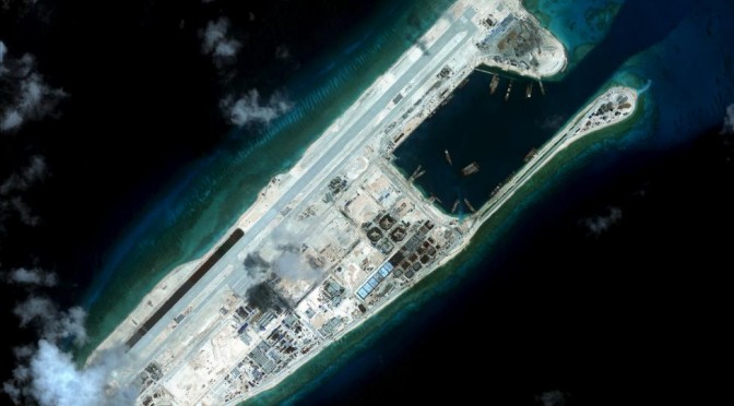
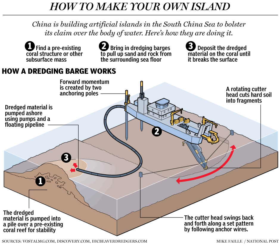
The burning question of freedom of navigation and overflight. Given the current controversy over FON (Freedom of Navigation) operations by the US Navy, along or together with partners and allies, close to China’s artificial islands in the South China Sea, this is an aspect of Beijing’s paper of great interest to observers. Concerning this, section 28 stresses that “China always respects the freedom of navigation and overflight enjoyed by all States in the South China Sea in accordance with international law.” While this is in line with repeated assertions by Chinese authorities, it prompts further doubts on the exact nature of Beijing’s claims, in the sense that if all it was demanding was an EEZ then freedom of navigation and overflight would simply flow from international law, without the need for any concession by the coastal state. The issue is made more complex by the fact that in Beijing’s view the rights of coastal states are more extensive than in the eyes of countries such as the United States, going as far as including the right to authorize or deny military activities such as electronic intelligence gathering, which has been the source of a number of incidents, some of them fatal. Thus, if what China is claiming is an EEZ, is Beijing making a concession and accepting a lesser set of coastal state rights in the particular case of the South China Sea? Alternatively, should we read “freedom of navigation and overflight” as being restricted to civilian ships and planes, or at least not including any activities such as ELINT (electronic intelligence) gathering, prejudicial to the coastal state? Other questions may be prompted by China’s assertion. For example, does this also apply to territorial waters around Chinese islands in the South China Sea? A question made more complex by the fact that there is no agreement over which islands are islands there, in particular given the extensive reclamation work taking place.

Read the next installment here

Alex Calvo is a guest professor at Nagoya University (Japan) focusing on security and defence policy, international law, and military history in the Indian-Pacific Ocean Region. A member of the Center for International Maritime Security (CIMSEC) and Taiwan’s South China Sea Think-Tank, he is currently writing a book about Asia’s role and contribution to the Allied victory in the Great War. He tweets @Alex__Calvo and his work can be found here.

[otw_shortcode_button href=”https://cimsec.org/buying-cimsec-war-bonds/18115″ size=”medium” icon_position=”right” shape=”round” color_class=”otw-blue”]Donate to CIMSEC![/otw_shortcode_button]

South China Sea arbitration: Beijing puts forward her own views Part One

By Alex Calvo

Introduction: restatement or small Filipino victory? Manila’s international arbitration bid has been repeatedly rejected by Beijing, which argues that it does not fall under the compulsory arbitration provisions of UNCLOS. Even after the Court ruled on jurisdiction, on 29 October 2015, China stuck to this position, as clear from an official statement the following day. However, despite repeatedly refusing to appear before the court, last year Beijing chose to issue a formal document stating her posture. For some this may simply be a restatement of China’s position, confirming that it will not take part in the proceedings. For others, it amounts to a small victory for the Philippines and the rule of law at sea, since China has finally been unable to completely ignore the proceedings. Whatever one thinks about it, it is useful to examine the document, dated 7 December 2014 (unclear whether any pun intended), while we wait for the Permanent Court of Arbitration to hold the first oral hearings on the substantive aspects of the case, scheduled for late November 2015. We shall be doing so in this four-part series.

[otw_shortcode_button href=”https://cimsec.org/buying-cimsec-war-bonds/18115″ size=”medium” icon_position=”right” shape=”round” color_class=”otw-blue”]Donate to CIMSEC![/otw_shortcode_button]

Chinese attitudes towards international law. Post-Mao China has followed a somewhat contradictory approach to international law. To a large extent, this mirrors the country’s complex domestic relationship with the concept of the rule of law. On the one hand, China’s reopening of her law schools after the Cultural Revolution and huge expansion of the legal profession and the practical, day to day, presence of the law, has led to a similar move in the international arena. However, this greatly expanded role of the law both domestically and internationally has been accompanied, in the internal domain, by a persistent rejection of the concept of “rule of law”, authorities rather leaning towards “rule by law.” In Chinese foreign relations, international law has had to contend with two obstacles. First, there is a mistrust of international tribunals, and the fear that they may impinge on Chinese sovereignty. Moreover, the South China Sea has been defined as a “core national interest,” although the exact meaning of this term may not be completely clear. Second, with the notion that public international law is a creature of Western nations and thus inextricably linked to a historical period of foreign domination that only began to be reversed after the 1949 Communist victory, or now that Chiang Kai-shek seems to be enjoying some sort of rehabilitation in China the 1943 Cairo conference. This applies particularly to the law of the sea, seen as unfairly constraining the legitimate aspirations of a nation that has grown increasingly dependent on maritime trade and which feels surrounded by a chain of islands in hostile hands.

The paper’s purposes, according to Beijing. After an introduction, making it clear that issuing the paper does not amount to taking part in the arbitral proceedings, the text lists in Paragraph 3 the main purposes of the paper, each such purpose covered in sections II to V. These goals are first of all (Section II, Paragraphs 4-29) to stress that the case concerns “the territorial sovereignty over several maritime features in the South China Sea,” which, contrary to Filipino assertions, “is beyond the scope of the Convention and does not concern the interpretation or application of the Convention.” Section III, Paragraphs 30-56 explains that “China and the Philippines have agreed, through bilateral instruments and the Declaration on the Conduct of Parties in the South China Sea, to settle their relevant disputes through negotiations” and that the arbitration proceedings are thus a breach by Manila of “its obligation under international law.” Section IV, Paragraphs 57-75 explains Beijing’s position that, “assuming, arguendo, that the subject-matter of the arbitration” was interpreting or applying UNCLOS, this would still be “an integral part of maritime delimitation” thus falling squarely within China’s derogation from compulsory arbitration. Section V, Paragraphs 76-85 underlines that “the Arbitral Tribunal manifestly has no jurisdiction over the present arbitration” and defends the view that China’s refusal to take part in the proceedings stands “on solid ground in international law.” These sections are followed by a set of Conclusions (Section VI, Paragraphs 86-93).

The 1898 Treaty of Paris in the PRC’s narrative of the conflict. In Section II, the document (5) explains that “Prior to the 1970s, Philippine law had set clear limits for the territory of the Philippines, which did not involve any of China’s maritime features in the South China Sea,” citing Article 1 of the 1935 Constitution, which reads “The Philippines comprises all the territory ceded to the United States by the Treaty of Paris concluded between the United States and Spain on the tenth day of December, eighteen hundred and ninety-eight, the limits of which are set forth in Article III of said treaty, together with all the islands embraced in the treaty concluded at Washington between the United States and Spain on the seventh day of November, nineteen hundred, and the treaty concluded between the United States and Great Britain on the second day of January, nineteen hundred and thirty, and all territory over which the present Government of the Philippine Islands exercises jurisdiction.” It added that the 1961 Philippine Republic Act No. 3046, titled “An Act to Define the Baselines of the Territorial Sea of the Philippines,” confirmed such territorial limits.

Replica of one of Admiral Zheng He's treasure ships, built in 2014. As China turns to the sea, she is stressing his figure.
Replica of one of Admiral Zheng He’s treasure ships, built in 2014. As China turns to the sea, she is stressing his figure.

Setting aside for a moment whether Manila has indeed redefined the limits to her national territory, this is potentially very significant because as reiterated in last year’s US Department of State “Limits on the Sea” No 143 paper, devoted to China, Washington has persistently stressed that it was taking no sides concerning the ultimate issue of sovereignty. Yet, while this may be sustainable in the case of other territorial disputes in the region, the case of the Philippines is rather different, given that the country was under US sovereignty for more than half a century. Thus, whatever one makes of Beijing’s case, it is difficult not to agree that past treaties signed by the United States may be relevant to the issue at hand. A question may be what, if any, may be Beijing’s motivation in bringing up such treaties, in addition to providing arguments in favor of its posture concerning the extent of Filipino territorial claims. Is Beijing perhaps hoping to prompt Washington to publicly comment on the matter in a way that may be detrimental to Manila? Or to quietly lean on the Philippines not to go too far? These may be speculative questions, yet ones difficult to avoid given the complex nature of the South China Sea dispute, with not only different immediate players, that is the coastal states, but plenty of other interested contenders, including the United States, Japan, India, and Russia. China’s document also refers to a UK-US Treaty, and while London has traditionally chosen a low profile posture in the region, it has recently been upgrading defense cooperation with Japan. Going back to Washington, the possible impact of past treaties and other diplomatic practice has already been considered important by observers in the case of Taiwan and the Senkaku/Diaoyu/Diaoyutai Islands, given Formosa’s change of status following the end of the Second World War and the American occupation of the Ryukyu Archipelago for three decades after its conclusion. However, the connection with the United States is much closer in the case of the Philippines, and Washington’s non-committal posture on sovereignty may come under increased pressure, although as mentioned this could result from different, even opposed motivations. 

Read the next installment here

Alex Calvo is a guest professor at Nagoya University (Japan) focusing on security and defence policy, international law, and military history in the Indian-Pacific Ocean Region. A member of the Center for International Maritime Security (CIMSEC) and Taiwan’s South China Sea Think-Tank, he is currently writing a book about Asia’s role and contribution to the Allied victory in the Great War. He tweets @Alex__Calvo and his work can be found here.

[otw_shortcode_button href=”https://cimsec.org/buying-cimsec-war-bonds/18115″ size=”medium” icon_position=”right” shape=”round” color_class=”otw-blue”]Donate to CIMSEC![/otw_shortcode_button]

Can’t Anybody Play This Game? US FON Operations and Law of the Sea

This article originally featured on Lawfare. It may be read in its original form here

By Raul “Pete” Pedrozo and James Kraska

The United States has been unable to synchronize successful air and sea freedom of navigation (FON) operations in the South China Sea with an erratic diplomatic message and a legal case that is too clever by half. Our colleagues Bonnie Glaser and Peter Dutton tried to reconnect these dimensions when they wrote in the The National Interest that while the administration has not done a “stellar job of explaining its actions,” the U.S. approach was still a sophisticated signaling mechanism. But their laudable effort to square the circle is not supported by the law of the sea.

Here’s why.

The past two FON operations in the South China Sea – the USS Lassen (DDG 82) surface navigation on October 27 and the flight of B-52s on November 8-9 – are models in how to squander flawless operational execution with confused, inconsistent, and ultimately damaging messaging that in some ways left the United States in a worse position than it would have been had it not done the operations.

After more than a month of dithering, the United States ordered the USS Lassen to challenge something – many are still unsure what – in the South China Sea. Some American officials characterized the operation as “innocent passage,” while others described it as “not innocent passage.” As confusion over the true nature of the FON challenge mounted, Senator John McCain requested the Department of Defense to “publicly clarify…the legal intent behind this operation.” Just days later, the U.S. did it again. Air Force B-52 bombers from Guam overflew the South China Sea. A U.S. official told The Hill that the aircraft did fly within 12 nm of China’s artificial islands, whereas another U.S. official said it did not. The confusion in both cases appears to be a mixture of politics combined with a lack of understanding of the law of the sea, presenting the United States with two unforced errors that should not be repeated.  

The legal implications of the Lassen operation are inexplicable to this day. The Lassen could not have transited near Subi Reef in innocent passage because the feature is a low-tide elevation (LTE) that does not generate a territorial sea. High seas freedoms apply around low-tide elevations. Although Subi Reef is a an LTE, it is located within 12 nautical miles (nm) of Sandy Cay, an uninhabited rock that is entitled to a 12 nm territorial sea. Under article 13 of UNCLOS, an LTE located within the 12 nm territorial sea of a “mainland or island” may generate a territorial sea as though it were itself a rock. Accordingly, Glaser and Dutton conclude that Subi Reef was used “as a baseline to ‘bump out’ the territorial sea” of Sandy Cay. Under this theory, the USS Lassen was compelled by law to transit the territorial sea of Sandy Cay/Subi Reef in innocent passage.

There are four reasons why this rationale is unsupported by the law of the sea. First, article 13 of UNCLOS clearly states that an LTE within 12 nm of a “mainland or island” may extend out the territorial sea of the primary feature as though it were a rock. This is called a “parasitic” LTE, since its territorial sea depends on an adjacent mainland or island. But Sandy Cay is neither a mainland nor an island – it is a rock, so it may not be used by Subi Reef to generate a territorial sea.

Our colleagues appear to suggest that “mainland or island” includes mere rocks – that islands are just a form of rock. This argument confuses the text in Article 121 on the regime of islands, which forms Part VIII of the Convention and addresses what features are entitled to an exclusive economic zone (EEZ) with the rules in Part II on the territorial sea. Islands are naturally formed areas above water at high tide [Article 121(1)]. Islands are entitled to the full suit of zones of sovereignty, sovereign rights, and jurisdiction [Article 121(2)]. All that Article 121(3) says is that “rocks which cannot sustain human habitation or an economic life of their own” are not entitled to an EEZ or continental shelf. This text does not mean that islands are simply a type of rock – they are not and to make this argument is a circular reading that defies the negotiating history of the convention that sought to distinguish rocks from islands, as well as common sense that would have the two distinct words imbued with two discrete meanings.

Furthermore, the feature of one country cannot be used to generate maritime entitlements for a feature of another country. The only way for Subi Reef to be a parasitic LTE and have a territorial sea generated from Sandy Cay’s territorial sea is if the same country has lawful sovereign title to both features. Is the United States ceding both features to China?

Second, perhaps more fundamentally, no feature in the Spratly Islands, including Subi Reef, has a territorial sea. None. UNCLOS Article 3 allows states to “establish” a territorial sea – it is not automatic. Neither China nor any other claimant has established a territorial sea around a feature in the Spratly Islands. The law of the sea requires affirmative action by a sovereign state – China has not done so, so why does the United States appear to recognize (and therefore encourage) such action? There is no territorial sea around Subi or any other Chinese occupied feature, and therefore no purported requirement in Chinese law for prior consent of transit for the Lassen to challenge. Whether U.S. ships or aircraft stay beyond or transit within 12 nm of any these features is legally immaterial – none of them have a territorial sea.

Third, in order for a rock to generate a territorial sea it must be under the sovereignty of a coastal state. The United States does not recognize any country as having sovereignty over the features occupied or claimed by China, and in fact China has the weakest claim to the features of any nation in the region. No country recognizes China’s claim of sovereignty over any Spratly feature. Consequently, even if China declared a territorial sea around one or more feature, which it has not, the declaration would be legally nugatory. It would be the same as the United States declaring a territorial sea around Antarctica – no other state would recognize it. So why does the United States appear to recognize Chinese sovereignty over any of these features by trying to challenge provisions of Chinese law that even China has refrained from imposing?

Fourth, Glaser and Dutton suggest the Lassen challenged China’s law that purports to require prior notification for innocent passage in its territorial sea. Yet the operation appears to have been leaked to the media by a U.S. official the day before it was conducted, giving de facto notice – probably in a vain effort to “reduce tension” over the transit. That move undermined the U.S. legal case and created operational risk. It was not a coincidence that China’s maritime militia was already in position to harass the Lassen when the U.S. warship approached Subi Reef – potentially placing the security of the mission and the lives of U.S. Sailors at risk.

So did the FON operations challenge anything at all? Yes, but not what the United States or outside observers have claimed. Both the Lassen and the B-52s challenged China’s ubiquitous nine-dashed line claim to “indisputable sovereignty” over the South China Sea. Of course nobody, including our interlocutors in Beijing, have any idea what China’s preposterous claims mean in terms of the law of the sea. The difficulty in trying to fit U.S. FON operations into the prism of the law of the sea – combined with a lack of understanding of the law of the sea – has driven U.S. officials and pundits bananas. This falls into the trap laid by China, which has, at least since 1995, intentionally used confusion and ambiguity over its maritime claims in the South China Sea as a strategic weapon. It would be far better for the United States to continue to operate freely, persistently, and without the hand-wringing and drama, with ships on the surface, submarines under the water, and aircraft in overflight of the South China Sea, within and beyond 12 nm of all the features in the region.  

Raul “Pete” Pedrozo is Deputy General Counsel for the Defense POW/MIA Accounting Agency (DPAA). Previously he was a Professor of International Law in the Stockton Center for the Study of International Law at the U.S. Naval War College, where he now serves as a Non-Resident Scholar.

James Kraska is Howard S. Levie Professor of International Law at the Stockton Center for the Study of International Law, U.S. Naval War College, Distinguished Fellow at the Law of the Sea Institute, University of California at Berkeley School of Law, and Senior Fellow, Center for Oceans Law and Policy, University of Virginia School of Law.

Yours, Mine, and Moscow’s: Breaking Down Russia’s Latest Arctic Claims

This article originally featured on CIMSEC on August 25, 2015, and has been updated for inclusion into the Russia Resurgent Topic Week. 

By Sally DeBoer

On August 4th, the Russian Federation’s Foreign Ministry reported that it had resubmitted its claim to a vast swath (more than 1.2 million square kilometers, including the North Pole) of the rapidly changing and potentially lucrative Arctic to the United Nations. In 2002, Russia put forth a similar claim, but it was rejected based on lack of sufficient support. This latest petition, however, is supported by “ample scientific data collected in years of arctic research,” according to Moscow. Russia’s latest submission for the United Nation’s Commission on the Limits of the Continental Shelf’s (CLCS) consideration coincides with increased Russian activity in the High North, both of a military and economic nature. Recent years have seen Russia re-open a Soviet-era military base in the remote Novosibirsk Islands (2013), with intentions to restore a collocated airfield as well as emergency services and scientific facilities.  According to a 2015 statement by Russian Deputy PM Dmitry Rogozin, the curiously named Academic Lomonsov,  a floating nuclear power plant

Academic Lomonsov under construction. Please click on the image for its source.

built to provide sustained operating power to Arctic drilling platforms and refineries, will be operational by 2016. Though surely the most prolific in terms of drilling and military activity, Russia is far from the only Arctic actor staking their claim beyond traditional EEZs in the High North. Given the increased activity, overlapping claims, and dynamic nature of Arctic environment as a whole, Russia’s latest claim has tremendous implications, whether or not the United Nations CLCS provides a recommendation in favor of Moscow’s assertions.

The Claim:

Russia’s August 2015 claim encompasses an area of more than 463,000 square miles of Arctic sea shelf extending more than 350 nautical miles from the shore. If recognized, the claim would afford Russia control over and exclusive rights to the economic resources of part of the Arctic Ocean’s so-called “Donut Hole.” As the New

A depiction of the "Donut Hole."
A depiction of the “Donut Hole.”

York Times’ Andrew Kramer explains, “the Donut Hole is a Texas sized area of international waters encircled by the existing economic-zone boundaries of shoreline countries.” As such, the donut hole is presently considered part of the global commons. Moscow’s claim is also inclusive of the North Pole and the potentially lucrative Northern Sea Route (or Northeast Passage), which provides an increasingly viable shipping artery between Europe and East Asia. With an estimated thirteen percent of the world’s undiscovered oil and thirty percent of its undiscovered natural gas, the Arctic’s value to Russia goes well beyond strategic advantage and shipping lanes. Recognition by the CLCS of Russia’s claim (or any claim, for that matter) would  shift the tone of activity in the Arctic from generally cooperative to increasingly competitive, as well as impinge on the larger idea of a free and indisputable global common.

The Law:

As most readers likely already know, the United Nations’ Convention on the Law of the Sea (UNCLOS) allows claimants 12nm of territorial seas measured from baselines that normally coincide with low-water coastlines and an exclusive economic zone (EEZ)

A depiction of universal claims afforded by UNCLOS

extending to 200 nautical miles (inclusive of the territorial sea). Exploitation of the seabed and resources beyond 200nm requires the party to appeal to the International Seabed Authority unless that state can prove that such resources lie within its continental shelf. Marc Sontag and Felix Luth of The Global Journal explain that “under the law, the continental shelf is a maritime area consisting of the seabed and its subsoil attributable to an individual coastal state as a natural prolongation of its land and territory which can, exceptionally, extend a states right to exploitation beyond the 200 nautical miles of its EEZ.”  Such exception requires an appeal to the Commission on the Limits of the Continental Shelf (CLCS), a panel of experts and scientists that consider claims and supporting data.  Essentially, the burden is on Russia to provide sufficient scientific evidence that its continental shelf (and thus its EEZ) extends underneath the Arctic. In any case, as per UNCLOS Article 76(5), such a continental shelf cannot exceed 350 nm from the established baseline. Russia’s latest claim is well beyond this limit; the Federation has stated that the 350 nm limit does not apply to this case because the seabed and its resources are a “natural components of the continent,” no matter their distance from the shore.

The CLCS will present its findings in the form of recommendations, which are not legally binding to the country seeking the appeal. Though Russia has stated it expects a result by the fall, the commission is not scheduled to convene until Feburary or March of 2016 and, as such, there will be a significant waiting period before any recommendation will be made.

Rival Claimants:

Russia is far from the only Arctic actor making claims beyond the 200 nautical mile EEZ. Denmark, for instance, jointly submitted a claim with the government of Greenland expressing ownership over nearly 900,000 square kilometers of the Arctic (including the North Pole) based on the connection between Greenland’s continental shelf and the Lomonosov Ridge, which spans kontinsokkel_uknearly the entire diameter of the donut hole. This claim clearly overlaps Russia’s latest submission, which is also based on the claim that the ridge represents an extension of Russia’s continental shelf. Though there is no dispute on the ownership of the ridge, both Russia and Denmark claim the North Pole.  Both nations have recently expressed a desire to work cooperatively on a resolution, though a Russian Foreign ministry statement did estimate a solution could take up to 10-15 years. Also of note: this has note always been Russia’s tune on the matter (See here and here).

Similarly, Canada is expected to make a bid to extend its Arctic territory. Notably, Canada claims sovereignty over the Northwest Passage, a shipping route connecting the Davis Strait and Baffin Bay based on historical precedent and its orientation to baselines drawn around the Arctic Archipelago. The U.S. maintains that the Northwest Passage should be an international strait. Though they have yet to submit a formal claim to the UN’s CLCS, one has reportedly been in preparation since 2013. According to reports, Canada delayed a last-minute claim at the behest of PM Stephen Harper, who insisted the claim include the North Pole. If this holds true, Canada’s claim will likely overlap both Russia and Denmark’s submissions to the CLCS.  If the CLCS were to recognize the legitimacy of two or more states’ overlapping claims, the actors have the option to bilaterally or multilaterally resolve the issue to their satisfaction; developing such a resolution is beyond the scope of the commission.

Implications:

Likely, Russia’s submission to the United Nations is part of a larger campaign by Moscow to reassert and re-establish its influence in the international order by virtue of its status Arctic influence. Regardless of approval or rejection by the UN, Russia’s expansive claim highlights Moscow’s very serious intention to control and exploit the Arctic. As the Christian Science Monitor’s Denise Ajiri explains, “a win would mean access to sought after resources, but the petition itself underscores Russia’s broader interest in solidifying its footing on the world stage.” With much of Western Europe reliant on Russian oil and natural gas, the Arctic and its resources represent an opportunity for the Kremlin to boost their position in the international order and develop a source of sustained and significant income. Russia may be acting within the letter of the law on the issue of their claim at this time, but it’s hard to separate that compliance from the Federation’s significant investment in the militarization of the Arctic, frequent patrols along the coastline of Arctic neighbors, and expenditure on the economic exploitation of the High North. For now, the donut hole remains part of the global commons and therefore free from direct exploitation or claim of sovereignty.  The burden of proof on any one state to claim an extension of their continental shelf is truly enormous, but as experts and lawyers at the CLCS pore over these claims, receding Arctic ice combined with economic and strategic interests of the claimants will likely increase the claimants’ sense of urgency.

Sally DeBoer is a 2009 graduate of the United States Naval Academy and a recent graduate of Norwich University’s Master of Arts in Diplomacy program.  She can be reached at Sally.L.DeBoer@gmail(dot)com or on twitter @SallyDeBoer.

CIMSEC content is and always will be free; consider a voluntary monthly donation to offset our operational costs. As always, it is your support and patronage that have allowed us to build this community – and we are incredibly grateful.
Select a Donation Option (USD)

Enter Donation Amount (USD)