Hello, this time it’s slightly more somber than normal, but is certainly very much another historically informed maritime current events podcast! Or Bilge Pumps as we three naval geeks of yore call it.
So what is episode seven all about? Well the #Bilgepumps team are being both ultra-topical and ultra-historical, as in this episode, recorded on the 15th of July 2020, we considered the fire that raged through USS Bonhomme Richard as well as the realities and difficulties of damage control on ships. Moving on from this we consider the options facing the U.S. Navy as it is now presented with a significant capability gap. Finally, we go with Tauvine’s suggestion of what battles or operations should really become movies?
#Bilgepumps is still a new series and new avenue, and although possibly no longer having the new car smell, we are getting the impression that it’s liked. But now we need you. Do you have suggestions for topics? Comments on how we could improve? Or most importantly, ideas for artwork, then please either tweet them to us the Bilgepump crew (with #Bilgepump) at Alex (@AC_NavalHistory), Drach (@Drachinifel), and Jamie (@Armouredcarrier). Or you can comment on our Youtube channels (listed down below).
International maritime security needs a dramatic shift in thinking and commitment to the greatest transnational threat of the twenty-first century. It is not drug trafficking which, while impactful in criminal behavior and the unfortunate consequences to consumers and their families, is not an existential threat. Nor is terrorism, specifically maritime terrorism, the primary concern. While maritime terrorism has occurred, it has been rare; and while it must be addressed and perpetrators brought to justice, the frequency of incidents (USS Cole, MV Limburg, Mumbai, and so on) have been comparatively few and far between.
Instead, the international community needs to turn to mid-twentieth century psychologist Abraham Maslow whose hierarchy of needs suggest that security and safety are important but are secondary to physiological needs for any person: rest, warmth, water, food.
Food is central to warfighting and to national stability. Whether it was Napoleon or Frederick the Great who said that an army marches on its stomach, the concern over the availability of food is apparent in medieval sieges or Julius Caesar’s near obsession about the availability of corn for his legions or denying it to his enemies as he discusses in his work, The Gallic Wars. The same is true for access to grain in the Sicilian Expedition, the Roman Empire’s ties to Egypt, or in some of the decision-making in major campaigns.
In terms of maritime security, maritime life provides the most fundamental need for protein. Contrary to the popular adage used in another context, there aren’t always other fish in the sea. Fish consumption continues to increase with population, but the population of fish doesn’t necessarily increase with human demand. It is difficult to find a report on fishing that doesn’t paint a bleak picture of overfishing in most waters. Marine protein for people and as fishmeal for cattle is growing unabated. Some dire reports suggest that by mid-century commercial fishing will be unviable due to fish depletion. Fish as a resource will be fought over just as spice and oil have been the cause of conflicts, but it could be far worse considering that spice was a nicety and not a necessity in the hierarchy of needs. And while all nations are dependent on oil economically, its unavailability would not be as immediately life-threatening as would the disappearance of fundamental marine protein. In fact, some countries have already begun firing on fishing vessels intruding on local waters. This is the canary in the coal mine for maritime security.
At nearly every maritime forum, audiences are reminded of the 90/80/70 percentages: the proportions of shipping by water, human population that lives near the water, and surface of the Earth that is covered by water. In this case, we need to consider a new set of numbers that affects maritime security, 50/40/30/20, including:
30 percent of the world’s fishing fleet is Chinese
20 percent of global fish is caught illegally
Part of the problem is that 20 percent, otherwise known as Illegal, Unreported, and Unregulated (IUU) fishing. One needs only read the work being done at the Pew Charitable Trusts or the superlative journalism by reporterIan Urbina that cast a light on illegal fishing and its relationship to other security issues. 20 to 30 percent of fish sold in the United States, for example, was caught illegally. It can be higher elsewhere.
The U.S. Navy is not in the business of dealing with illegal fishing, as one senior Navy advocate once told this author. “That is not our job. It is not our mission. We have China to deal with.” China is at the heart of the problem given how its fishing fleets have moved well beyond the South China Sea to nearly all parts of the globe in recent decades. The issue is recognized by the current U.S. administration: “The PRC ranks first in the world for illegal, unreported, and unregulated fishing in coastal nations’ waters around the world, threatening local economies and harming the marine environment. Chinese leaders’ unwillingness to rein in these globally harmful practices does not match their rhetorical promises of environmental stewardship.” In Congress, the Maritime SAFE Act to address the threat of IUU fishing to national security was incorporated in the National Defense Authorization Act of 2020. Just a few elements of this legislation direct the inclusion of counter-IUU fishing as part of the mission of the Combined Maritime Forces, including counter-IUU fishing exercises in the annual at-sea exercises conducted by the Department of Defense, in coordination with the United States Coast Guard, and creating partnerships similar to the Oceania Maritime Security Initiative and the Africa Maritime Law Enforcement Partnership in other priority regions. It also encourages shiprider agreements.
The Navy would understandably resist this added mission for a variety of reasons. Organizationally, it changes very slowly, and is fundamentally opposed to shifting some construction resources from capital ships to smaller vessels that would be more appropriately suited for maritime security missions such as IUUF partnerships. Influential defense contractors are also predisposed to larger ship programs given the financial considerations. In addition, some of the most threatened areas, such as off the coast of West Africa, are not where the Navy can invest many assets given other threats and missions in the Western Pacific and the Middle East. While the Coast Guard is the authoritative choice on countering IUU fishing, it needs more resources, particularly given the cost of even just prosecuting captured vessels.
However, the Navy is deeply involved in great power competition, and IUU fishing is now part of that dynamic. Diminishing marine protein has the potential to destabilize China, given its insatiable appetite to feed its enormous population, and that increases the risk it poses to other nations as it tries to satisfy its essential needs at others’ expense. China will increasingly pressure states for access to their waters or outright impose itself as it has already done before. In the near term, IUU fishing denies local populations resources and economic benefits from marine protein. Today, Chinese fishing vessels are plying global waters for their own interests, but tomorrow, their white hulls will follow to protect these interests. And then, given the quickly growing size of the Chinese Navy, gray hulls will eventually ensure that fishing fleets go virtually unimpeded by any nation.
To counter this, the Department of Defense should establish a new Joint Interagency Task Force for IUU fishing (JIATF-IUUF) that has initial responsibilities off Africa. Such a JIATF, ideally led by U.S. Coast Guard officers, must work closely not only with partnered nations but with nongovernment organizations which have been at the forefront of the IUU fishing challenge. Organizations such as Global Fishing Watch, C4ADS, and others ought to be consulted, as should the Sea Shepherd Conservation Society, which has shifted its focus from challenging Japanese whalers in the Southern Ocean to successful public-private partnerships, especially in Africa. Sea Shepherd provides platforms and crews while the partnered host nations embark law enforcement detachments. This has resulted in the capture or seizure of more than 50 illegal fishing trawlers in recent years. Sea Shepherd, an organization with more than a dozen ships globally, is able to operate for about $10 million annually (due in part to most of the crew being unpaid volunteers). Whether the U.S. Government is willing to admit it or not, Sea Shepherd is providing capacity building and maritime partnerships that have been successful. In some cases, it has used former Coast Guard cutters. But the fact they are able to have such an impact at low cost ought to be looked at as a possible model for future U.S. partnerships.
Conclusion
Between NGOs, elements of U.S. government agencies, and Congressional legislation, there are positive moves toward addressing IUU fishing. Given the rapid depletion rates of fish stock, China’s growing global presence, and the impact of IUU fishing on economies, more action must be taken. Part of that action requires a reassessment of real innovative and adaptive measures that NGOs have used in partnership with host nations to counter what may be the greatest challenge in the twenty-first century.
Commander Claude Berube, USNR, PhD teaches at the U.S. Naval Academy. The views expressed are his and not necessarily those of the Academy or the Navy.
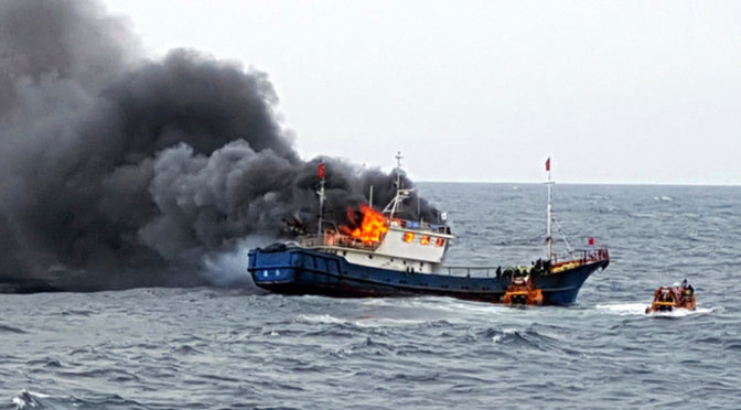
Featured Image: A Chinese fishing boat caught fire during an inspection by the South Korean Coast Guard on Friday. (South Korean Coast Guard photo)
The United Nations Convention on the Law of the Sea(UNCLOS) specifies that all ships “have the nationality of the State whose flag they are entitled to fly.” Consequently, flag states exercise jurisdiction over their flagged vessels. A recent and quickly growing phenomenon, however, has put this basic tenet of the law of the sea in question: unauthorized flag use.
Unauthorized flag use is a practice whereby a vessel uses a state’s flag without its consent and, oftentimes, without its knowledge. Although this can take many forms, often overlapping, it may be helpful to think of this issue in two broad categories: fraudulent flagging and false flagging. Fraudulent flagging generally entails an official recognition of fraudulent registration, e.g. fraudulently issued registration documents resulting in formal recognition by the International Maritime Organization (IMO). False flagging, on the other hand, describes a situation where a vessel falsely claims registration different than the flag it is actually authorized to fly as a matter of expediency. Both create a gap wherein there is no effective oversight of the vessel’s activities, which can be exploited to facilitate a range of illicit activities.
Fraudulent Flags, Real Issues
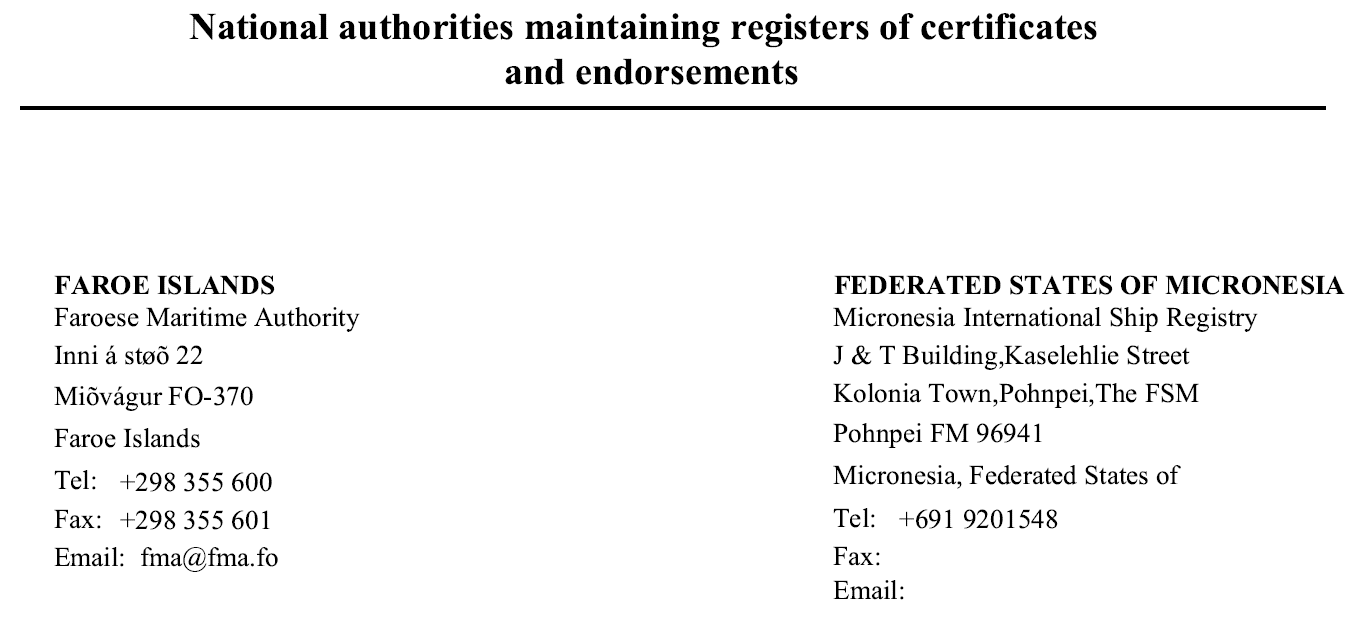
The issue of fraudulent flagging was brought to the attention of the international community in 2015, when the IMO became aware of a fraudulent registry purporting to operate on behalf of the Federated States of Micronesia. Micronesia does not operate an international shipping registry. It is not even an IMO Member State. Two years later, the Democratic Republic of the Congo (DRC) formally brought the issue to the attention of the IMO Legal Committee after discovering that 77 out of the 84vessels flying its flag have been doing so without authorization. Other countries have also fallen victim to fraudulent registration, including Fiji, Samoa, Nauru, Vanuatu and the Maldives. Although in some cases, like Nauru, the fraud was caught early enough that no fraudulent documents were ever issued, as of last year over 300 vessels are believed to have beenregistered fraudulently.
These fraudulent registrations are exploited by those engaged in illicit activity. In the case of the DRC, the country only became aware of the issue when contactedby INTERPOL with a request to prosecute two vessels engaged in illicit activity that claimed the DRC flag. Of the 98 vessels investigated by Fiji since 2017 for fraudulently claiming its flag at least 20 percent were subsequently linked to North Korea and likely engaged in sanctions evasion. Fraudulent registries not only deprive legitimate registries of income but can also cause significant reputational damage when vessels fraudulently flying a flag are involved in illicit activities. In just one example, the Maldives found itself having to officially denya statement by the Japanese Foreign Ministry which identified a supposedly Maldives-flagged vessel as engaging in a prohibited ship-to-ship transfer with a North Korean tanker.
In addition to enabling illicit activity and causing financial or reputational damage to legitimate maritime actors, fraudulent and false flagging can also adversely impact a range of other areas—maritime safety and security, environmental protection, and maritime emergencies among them. More broadly, as the resolution on the subject adopted by the IMO Assembly in January 2020 notes, unauthorized flag use “endanger[s] the integrity of maritime transport, and undermine[s] the legal foundation of the Organization’s treaty and regulatory regime.”
Despite that, the IMO response to the issue has been slow to come. While the organization has been aware of the problem at least since 2015, it was only in 2019 that it adopted any concrete measures to address it. One of these measures involved establishinga whitelist of authorized national registries and a procedure of verifying the information provided. This is particularly important given that the IMO had in the past erroneously recognized the fraudulent Micronesia International Ship Registry as a legitimate authorized body acting on behalf of the Micronesian government.
The fraudulent entity, Micronesia International Ship Registry, listed as the official registry representative in an IMO contact list circa early 2018. This has since been corrected.
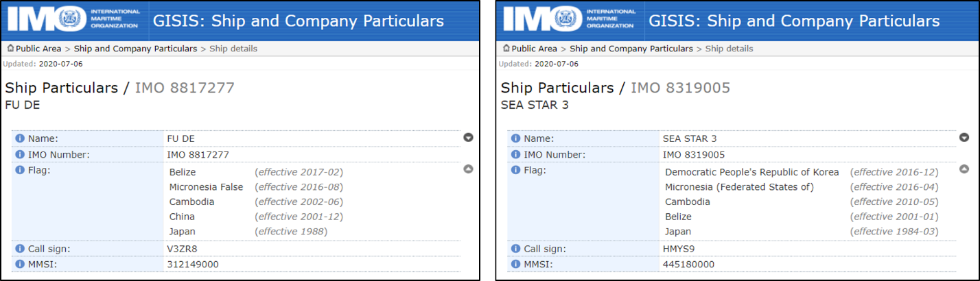
The other element—perhaps the most practically impactful—is the adoption of a new flag indicator in IMO records denoting fraudulent registrations. Adopted as an outcome of the March 2019 meeting of the IMO Legal Committee, it is intended to identify instances where a flag state has confirmed that a vessel was never legitimately registered. This, however, has been implemented inconsistently and likely only identifies a portion of vessels that have engaged in the practice. As an example, despite Micronesia having never operated a flag registry, not all vessels which had fraudulently claimed Micronesian registration are marked with the ‘false’ indicator in the IMO’s Global Integrated Shipping Information System (GISIS).
Entries for the FU DE and SEA STAR 3 in the IMO’s Global Integrated Shipping Information System (GISIS), only one of which notes Micronesia flag use as illegitimate. (Click to expand)
While these steps are welcome, they are insufficient to combat fraudulent flagging on their own. Indeed, the most impactful measure taken has been efforts by individual countries to denounce fraudulent registrations issued in their name. Marine circulars by Tuvalu and the Cook Islandsnote that Fiji reported the unauthorized use of its flag to the Tokyo MOU while Micronesia, Nauru, and Samoa reported the fake registries operating in their name to the IMO. Notifying multilateral organizations of the issue may have contributed to decreased unauthorized use of these countries’ flags: an annual reporton vessel inspections maintained by the Tokyo MOU shows drastic decreases in inspections of vessels flagged to both Fiji and Micronesia between 2017 and 2019. Inspections of vessels “registered” to Fiji went from 23 to four; those for Micronesia from 67 to zero.
False Flagging – Quicker and Easier
In comparison to the relative success combatting fraudulent flagging, false flagging poses a more complex challenge. This is because it is much easier to perpetrate: it does not require anchoring the deception in an official recognition by the IMO, but instead involves creating a false identity that is good enough to get away with illicit activity in the present moment. This includes broadcasting false identities via a vessel’s Automatic Identification System (AIS) transponder—a safety and navigation system whose use for most international vessels is mandated by International Convention for the Safety of Life at Sea(SOLAS)—or the fraudulent use of registration documents.
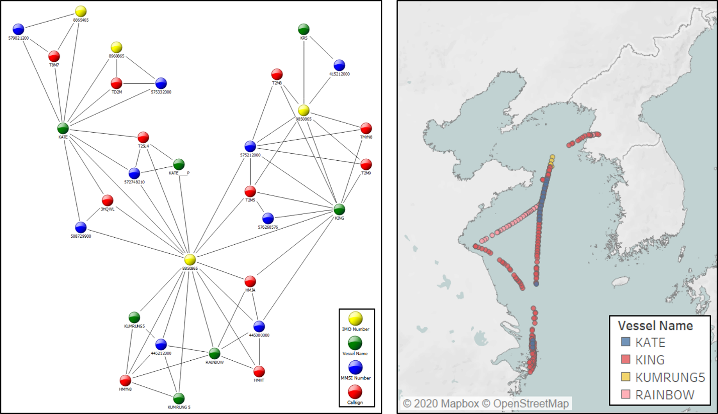
Broadcasting false identities using AIS transmissions is relatively straightforward as the identifiers broadcast are entered manually. This allows them to be changed frequently, complicating efforts to track a vessel’s activities. AIS transmissions using identifiers registered to the KUM RUNG 5, a North Korean cargo ship, for instance, show a vessel cycling through around 30 different identifiers, including names, Maritime Mobile Service Identity (MMSI) numbers, callsigns, and even IMO numbers, which are meant to be unique to just one vessel throughout its lifetime. This includes the use of at least four names in 2020 alone. Because the identifiers are programmed onboard the vessel, confirming the authenticity of the broadcast is not possible without other means of verification.
Identities affiliated with the IMO number registered to the KUM RUNG 5 (left) and locations of AIS transmissions and names broadcast in 2020 (right) based on AIS data from IHS Markit.
A vessel seeking to falsify an identity can also match the unique identifiers legitimately assigned to another vessel. In the case of a North Korea-flagged cargo vessel TAE YANG, investigated jointly by the James Martin Center for Nonproliferation Studies and the Royal United Services Institute, the vessel mimicked aspects of the identity of the Mongolia-flagged tanker KRYSPER SINGA. The AIS record initially broadcast by the TAE YANG with its assumed identity appeared to show the KRYSPER SINGA as having visited North Korea, while the real KRYSPER SINGA was actually off the coast of Singapore. Imagery, both satellite and ground, was necessary to verify that the AIS transmissions from North Korea were really coming from another vessel, the TAE YANG. Relying on AIS transmissions alone would have implicated an otherwise innocent vessel in a violation of United Nations sanctions on North Korea.
With regards to the use of fraudulent documents, the somewhat artificial distinction between fraudulent flagging and false flagging blurs. But a distinction, however minute, remains: fraudulent documents in the context of false flagging are used not to support a registration claim made to the IMO but to allow a vessel to navigate interactions with third parties when expedient. The case of the WISE HONEST is illustrative.
The WISE HONEST was a bulk carrier detained by Indonesia in 2018 for illicitly exporting coal from North Korea. At the time of the detention, it was registered to North Korea. Yet court documents show that the vessel initially identified itself to Indonesian authorities as being flagged by Sierra Leone—which it had been from August 2015 until May 2016. Authorities found two sets of documents onboard the vessel, one supporting registration with Sierra Leone, and one with North Korea. Although it is unclear whether the Sierra Leone documents found on the WISE HONEST in 2018 were an expired set of documents issued to the vessel in 2015 or a forgery, this case illustrates the ease with which legitimately issued documentation could be repurposed for illicit activity.
Building a Better Response
Although the measures adopted by the IMO are an important step toward addressing the problem of fraudulent and false flagging, a much more comprehensive response is needed. This should combine measures taken collectively by the appropriate international bodies, measures taken individually by states, and measures taken by the private sector.
At the international level, leadership by the IMO is crucial. Actions taken to date have been slow and limited in nature, largely hewing to IMO’s traditionally defined role. In addition to the two measures described above, the IMO has also issued a guidance on best practices to combat what it terms “fraudulent registration and fraudulent registries of ships.” The guidance urges states to make use of the registry whitelist and ‘false’ indicators in GISIS, verify the vessel’s IMO numbers and Continuous Synopsis Record prior to registration, and consult the UN sanctions lists. This guidance, however, does not go far enough. It does not seem to, for instance, address false flagging—the unauthorized use of a country’s flag absent fraudulent registration. Action to rectify this ought to include facilitating information sharing on vessels engaged in false flagging with the aim of allowing countries to better coordinate vessel de-registrations, detentions, and prosecutions, where applicable. Given IMO’s statutory functions, this naturally falls within the organization’s areas of responsibility.
At the national level, there are several steps countries can take.
First, implement national measures to prosecute fraudulent or false flagging and the illicit activity it facilitates, and enhance enforcement capabilities. Though fraudulent or false flagging may be illegal in some jurisdictions, this has not deterred vessels from engaging in the practice. This might have to do with how difficult enforcement action can be. Fiji opened criminal investigations into the unauthorized use of its flag in 2017. Its current status is unknown. Micronesia was finally able to bring charges in April 2020 against the individuals behind the Micronesia International Ship Registry—five years after the fraudulent registry first became active. Following the detention of the WISE HONEST in 2018, the only charges Indonesia could bring against the captain of the vessel were for “being in charge of an unseaworthy vessel.” It is unclear whether Sierra Leone tried, or would have been able to take any action in relation to unauthorized flag use.
Prosecution on the basis of the associated illicit activities—violations of United Nations sanctions on North Korea, for instance—could offer a supplemental pathway as well. Yet all too often, these measures are not appropriately implemented in national legislation. In many, if not most, cases, however, mutual legal assistance agreements would likely be necessary to take action effectively, given that vessels claiming a flag fraudulently may never be under the aggrieved party’s effective jurisdiction. The same is true of appropriate national enforcement procedures, without which any enforcement action will be difficult if not impossible. Exercises like those conducted under the banner of the Proliferation Security Initiative— a multinational response to the transnational threat of the proliferation of weapons of mass destruction—could focus on the ability to track and interdict a shipment and help build this capacity.
Second, invest in capabilities to monitor a broader set of vessel activity. In order to follow through on national legislation criminalizing fraudulent or false flagging, countries need to be able to identify it. Doing so requires investment in capabilities—both human and technological—to monitor vessel activity. Human capabilities entail relevant personnel knowing how to identify vessels engaged in fraudulent or false flagging. This is key to making sure that indicators of fraudulent or false flagging are noted and acted upon. Technological capabilities include the ability, likely via an AIS monitoring platform, to trace AIS transmissions linked to vessels in a country’s territorial waters to see if they have previously engaged in fraudulent or false flagging, and the ability to scan for AIS transmissions making unauthorized use of the country’s flag. Regional partnerships may offer smaller states, including those without international ship registries, a more cost-effective way of maintaining these capabilities.
Third, when it comes to assumed identities and identity theft perpetrated through AIS transmission, the way AIS transponders work is part of the problem: manual data entry makes fraud quite easy. The most recent advisory for the maritime sector issued by the U.S. government recommends that registry managers work with classification societies to provide a “soft lock” on AIS transponders, which would disable the option of manual changes during a vessel’s voyage while allowing for disablement in sanctioned emergency situations. This could go some way toward addressing the issue, although it would necessarily miss many of those actors already engaged in illicit activities who are not likely to allow for this sort of modification to their vessel’s equipment.
The private sector also has a role to play. To do so, it is important that AIS data providers and AIS monitoring platforms review how they aggregate data associated with false flagging. The ability of states to take action against those engaged in fraudulent or false flagging is contingent on the indicators of that practice being visible. As noted in the report on the TAE YANG, AIS data can be “corrected” or jettisoned when found to be associated with a vessel identity not registered with the IMO. This risks, in effect, erasing the illicit activity or making it harder to attribute. In the case of the TAE YANG, its AIS transmissions were merged with those of the KRYSPER SINGA and ultimately attributed to it. In other cases, like that of the KUM RUNG 5, AIS data for what is likely a single vessel may be grouped into different records on the basis of some of the false identifiers used by a vessel engaged in false flagging. Failure of data providers and maritime platforms to address these issues risks undermining faith in AIS as a means of monitoring vessel identities and activities—leaving national authorities and independent analysts with one fewer tool to monitor and disrupt illicit activity.
Conclusion
Fraudulent and false flagging is a complex issue requiring action from multilateral organizations like the IMO, national authorities, and the private sector. Each of these actors has a different set of incentives. Much is at stake for the private sector, including both data providers and the maritime industry that uses said data, and the reliability of AIS transmissions. For individual countries, their motivation comes from the reputational or financial costs they might incur as victims of unauthorized flag use. And for the international community writ large, with the IMO as the guardian of global maritime trade, the persistent and seemingly growing problem posed by fraudulent and false flagging—as the organization itself admits—threatens to undermine the entire legal regime it embodies. The temptation to pass responsibility for combatting unauthorized flag use to others is immense. But it is only through steps taken collectively by all relevant stakeholders that this problem can be addressed.
Cameron Trainer is a Research Associate at the James Martin Center for Nonproliferation Studies (CNS). His work focuses on identifying trends in illicit and sanctioned activities, often in relation to North Korea.
Paulina Izewicz is a Senior Research Associate and Project Manager at the James Martin Center for Nonproliferation Studies (CNS). Her work focuses on sanctions issues, with a particular focus on North Korea’s sanctions evasion in the maritime domain.
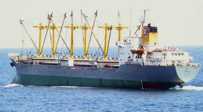
Featured Image: ARABIAN SEA (Oct. 30, 2007) – North Korean cargo vessel Dai Hong Dan transits off the coast of Somalia after the ship hijacked by pirates Oct. 29. (U.S. Navy photo)
This week, CIMSEC is excited to feature Project Trident’s second topic, ocean governance, presented in partnership with Stable Seas, a program of One Earth Future. Continuing the trend from Project Trident’s first topic, we will be extending the topic into a second week in order to accommodate the high number of quality submissions.
As an element of maritime security, ocean governance has traditionally been seen as the purview of law enforcement agencies and coast guards; however, the authors featured this week challenge this basic assumption, noting that challenges to long-established international norms from non-state actors and nation states (and the hybrid of both) threaten to upend global geopolitics. From false flags to illegal fishing to “grey areas,” the authors examine potential flashpoints in ocean governance that could dictate the future of international maritime security.
Authors note that while piracy and smuggling remain key issues around the world, ocean governance is becoming a major driver of regional economies as international actors vie for resources below the seabed of contested waters. Nowhere is this competition more on display than in the rapidly evolving Arctic; however, competition for energy and other economic resources will soon be in full swing in Southeast Asia and elsewhere.
Below is the lineup of articles featuring during the topic week, which will be updated as more publications are finalized.
Dmitry Filipoff is CIMSEC’s Director of Online Content. Contact him at Content@cimsec.org.
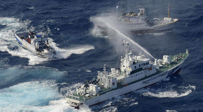
Featured Image: Coast guard vessels from Japan and Taiwan dueled with water cannons after dozens of Taiwanese boats escorted by patrol ships sailed into waters around the islands. (Yomiuri Shimbun/AFP/Getty Images)