Tag Archives: China

Leaning on the Big Switch in the Pacific: Why The United States Dominates Pacific Telecom Infrastructure

By Geoffrey L. Irving

Introduction

A combination of the United States’ nascent modern industrial policy, diplomacy, and aligned governmental and commercial interests have set the conditions for it to pull ahead in the race to control vital telecommunications infrastructure in the Pacific. The race to control telecommunications infrastructure is founded upon a number of small island nations and territories in the Pacific Ocean that last saw global attention during the island-hopping campaigns of the Second World War. This analysis will give particular focus to the nations and territories of Guam and the Solomon Islands and the effect that they have on subsea telecommunications infrastructure. Further, this analysis will review how competing American and Chinese telecommunication infrastructure strategies are affecting these Pacific Island nations and territories and how the convergence of the United States’ regulatory regimes, including “Team Telecom,” and commercial interests are dominating Pacific telecommunications.

The People’s Republic of China’s (hereinafter referred to as “China”) return to great power status is well-covered in national security circles and beyond. From construction of artificial islands in the South China Sea, to continued saber rattling directed at Taiwanese unification, to the infiltration of Chinese technology into the United States’ supply chains and defense industrial base, media and academic coverage of China’s return to global power often include dire warnings that the United States is unknowingly falling behind. However, there is one sector of Sino-American competition that currently bodes well for the United States and its allies, and deserves additional recognition and analysis; namely, the race to control international telecommunications infrastructure, and specifically the subsea fiber-optic cables that serve as the backbone of modern communication. 

Subsea communications infrastructure is the backbone of the modern way of life. More than 95 percent of international internet traffic flows across subsea fiber-optic cables.1 This data traffic includes all types of communications, from consumer phone calls, to streaming entertainment, financial transactions, or secure military or intelligence messaging.2 While high-profile satellite communications like those provided by SpaceX’s Starlink low earth orbit technology receive a lot publicity for their deployment in austere conditions, satellite data capabilities do not come close to matching the data capacity of fiber-optic cables.3

The concept of a subsea cable is relatively simple. Since the first subsea copper telegram cable was laid by the Atlantic Telegraph Company in 1858 between the North America and Ireland, cable technology has progressively matured with advances in materials science and information technology, although the operational concept has remained the same.4 A physical cable is spooled into the hull of a massive ship designed specifically for the task of laying and maintaining subsea cables.5 The ship then steams from one landing site across a body of water to another, laying cables and signal amplification units along the way. The cable, with its periodic amplifiers, sinks to the seafloor where it rests on top of seabed topography and uses relative obscurity and layers of armored sheathing to protect the delicate strands of glass fibers that carry light waves across thousands of miles.6 A tremendous level of complexity is required to execute this task; however, this simple explanation is meant to provide a basic understanding of the operations behind a subsea fiber-optic cable.

As the largest body of water in the world by far, the Pacific Ocean poses a particular challenge when laying subsea cables. Before the first Pacific subsea cable existed, reaching East Asia by electronic communication required either unreliable radio repeaters subject to the vagaries of weather and atmospheric conditions, or through a cable route that travelled across the Atlantic, through Cape Town, South Africa or Russia to a connecting cable to Japan or India.7 However, since the first Pacific cable was laid in 1903, cables across the Pacific have proliferated and now serve as the primary means to connect isolated Pacific Island Nations to the rest of the world.8 Additionally, in a bi-polar geopolitical environment internet connectivity and infrastructure is a key tool in drawing these nations towards alignment with the United States or China.9

Cable infrastructure is such an important piece of the geopolitical chessboard because its ownership and control can influence global data traffic and the contents of that traffic. Of particular note, as an overwhelming majority of financial transactions are negotiated, administered, and settled via electronic communications, if a party controls communications infrastructure, it can control the financial dealings of any client who relies on that infrastructure.10 For small Pacific Islands Countries, having a single cable connecting an island to the world wide web creates a single point of failure that can have extremely dire consequences if there is an unanticipated fault or break in the line – as there often are in subsea infrastructure.11 For example, in January 2022, an underwater volcanic eruption and landslide severed the only subsea cable connecting the island nation of Tonga to the outside world. As a result, it was nearly impossible to contact the island for a number of weeks.12 

China’s return to superpower status on the global stage has been accompanied by its audacious Belt and Road Initiative.13 This program funded massive infrastructure programs around the developing world to expand China’s diplomatic reach and to erode the international institutions of the post-Second World War international order. As a subset of the Belt and Road Initiative, China specifically focused on future technologies and set a goal to create a “Digital Silk Road” that would involve communication infrastructure projects driven by Chinese national champion state owned enterprises like Huawei and China Unicom.14 These projects were intended to include both the provision of 5G-capable network infrastructure for developing nations as well as subsea communications infrastructure to connect partner nations to China’s internet service providers. To this end, Huawei, an electronics hardware conglomerate, established Huawei Marine in 2009 to begin providing marine communications technology hardware and infrastructure services.15 Huawei Marine, as a newcomer to the maritime communications technology industry, had to compete with established Western companies like SubCom and Alcatel Submarine Networks to build and maintain subsea infrastructure.16

While the United States and its allies did not have the appetite to compete with China’s massive spending spree in the developing world, an alignment of government and commercial interests has led it and other western-aligned countries to dominate the communications landscape in the Pacific. As of this writing, no Chinese-owned or operated subsea cable is the sole provider for subsea communications to any Pacific Island.17 Further, networks generally reject any Huawei and other Chinese state-owned-enterprise communications and network hardware.18 This outcome bodes well for American interests in the Pacific, and the expanded provision of network capabilities to Pacific Island countries and territories will have beneficial economic impacts on local economies. In the following section, this paper will analyze case studies of Guam and the Solomon Islands as it relates to the competition of US and Chinese telecommunications providers and the expansion of Pacific telecommunications networks.

Case Study: Guam

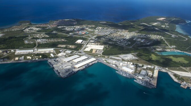
Guam is a small Pacific Island that is the southernmost island in the Mariana Island chain and is the largest island in Micronesia.19 Guam has a rich history of indigenous culture and position in contemporary history as a strategic way point in the Pacific Ocean for competing navies. Guam was a protectorate of the United States Navy following the end of the Spanish-American war in 1898 and then received formal recognition as an unincorporated territory with self-rule in 1950.20 Guam is also home to a large American military presence and hosts a U.S. Naval Base, an Air Force Air Field, and a burgeoning Marine Corps Base. Because it is the United States’ westernmost territory, Guam is also a landing point for many trans-Pacific cables, earning it the moniker “The Big Switch in the Pacific.”

The first transpacific cable landed on Guam in 1904 by a private enterprise led by John Mackay. This cable functioned until 1950 when a fault removed it from service leaving decades of inconsistent telecommunications connectivity until the advent and proliferation of fiber-optic cables. Following the advent of fiber-optic cables, there was an explosion of telecommunication activity on Guam evident by the laying of sixteen cables between 1987 and 2022 – roughly one cable every two years.21 See Figure 1.

Cable System Name Year Status
TPC-3 1987 Retired
GPT 1990 Retired
PacRim West 1995 Retired
Mariana-Guam (MICS) 1997 Currently lit
GP 1999 Retired 2011
Australia-Japan 2001 Currently lit
China-US 2001 Retired 2016
Tata TGN Pacific 2002 Currently lit
Asia-America Gateway 2009 Currently lit
PPC-1 2009 Currently lit
HANTRU1 2010 Currently lit
Guam Okinawa Kyushu Incheon 2013 Currently lit
Atisa 2017 Currently lit
SEA-US 2017 Currently lit
Japan-Guam-Australia North 2020 Currently lit
Japan-Guam-Australia South 2020 Currently lit
Echo 2023 Planned, not lit
Apricot 2024 Planned, not lit
Bifrost 2024 Planned, not lit
Asia Connect Cable 1 (ACC-1) 2025 Planned, not lit

Figure 1: A historic list of telecommunication cables landing on Guam

Despite sixteen cables laid on Guam over the past three decades, Guam’s telecommunications market is relatively small. Guam’s population is around 170,000 people, roughly the same as a midsized American city like Springfield, Missouri.22 Despite this small market, three competing internet and communications service providers compete for market share on the island – Docomo, IT&E, and GTA. As of 2017, Guam had an internet penetration rate of eighty-one percent among its population.23 As a US territory that hosts a large military footprint, Guam’s telecommunications network is largely insulated from Chinese intrusion. Measures such as Federal government regulation, import controls, and the Federal Communications Commission (FCC) largely block Chinese or Chinese-funded companies from penetrating the Guamanian telecommunications sector.24

Further, as a result of Guam’s strategic position as a gateway to Asia and wider trends in the telecommunications sector, many large US technology companies are vying to invest in data centers in Guam.25 These data centers will serve as edge storage and computing nodes for internet service providers with retail and commercial customers in the Indo-Pacific theater. This next wave of telecommunications infrastructure poses an additional benefit to Guam’s local economy, as the influx of investment to stand up data centers that rely on consistent power generation and stable climate will likely create increased opportunities for job growth and a local telecommunications expertise.

Because of these reasons, Guam’s role as the “Big Switch in the Pacific” has been a driver of its local economy and will likely continue to yield dividends as the telecommunications industry matures and seeks improved and additional infrastructure projects. Additionally, as the United States focuses its national security posture on the Pacific theater, Guam will likely see increased military investment which has both positive and negative effects on local culture, but inarguably injects additional capital into the small island.

Case Study: The Solomon Islands

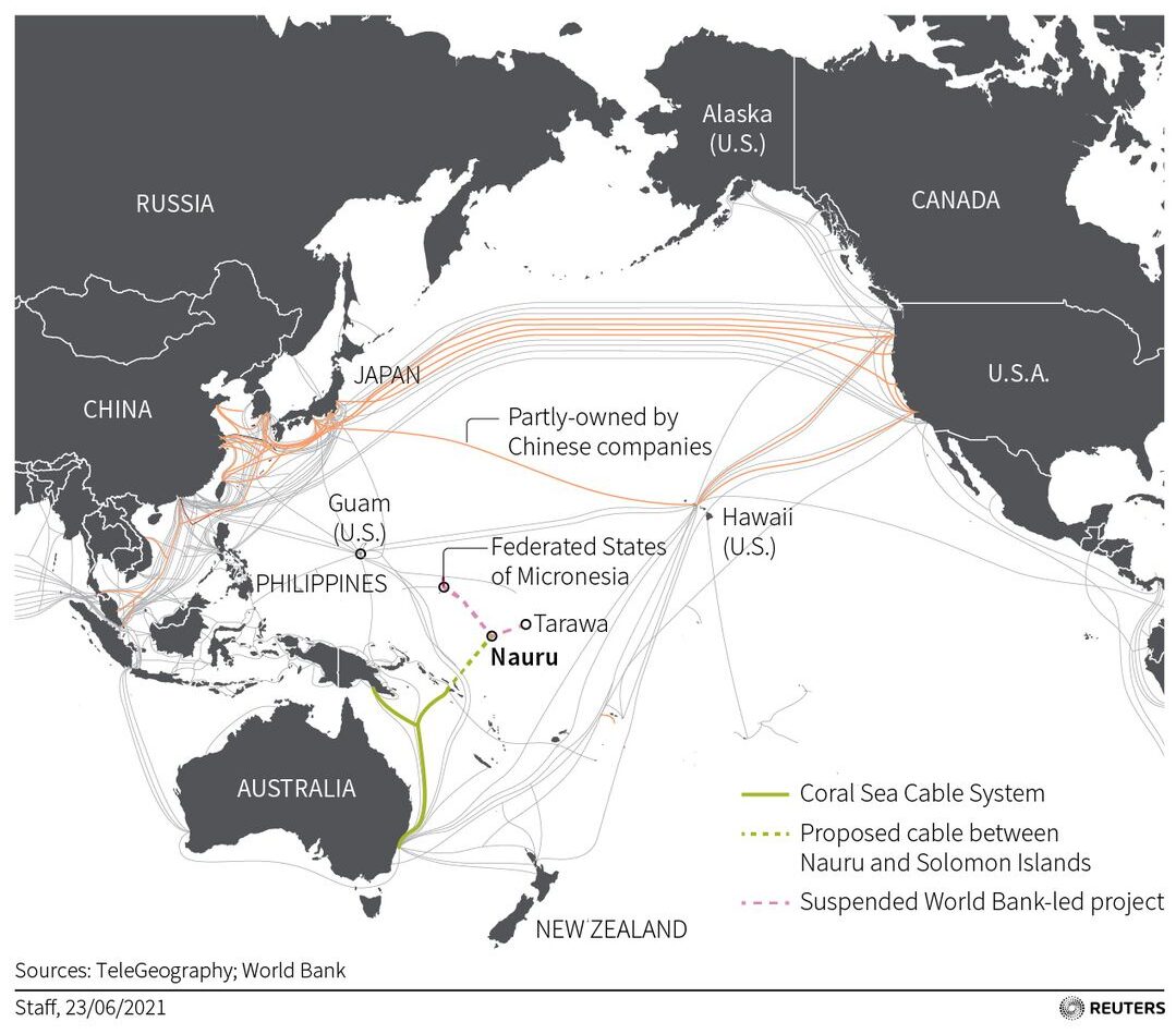
A study of the Solomon Islands’ telecommunications infrastructure and geopolitical position is an interesting counterpoint to Guam. Unlike Guam, the Solomon Islands is a sovereign nation state comprised of hundreds of islands off the East coast of Papua New Guinea and Northwest of Australia.26 The Solomon Islands have a population of approximately 700,000, but a gross domestic product of only $1.6 billion.27 Compared to Guam’s population of 170,000 and 2021 GDP of $5.8 billion, an apparent disparity exists as the Solomon Islands trails Guam’s development and productivity in terms of per capita GDP. Additionally, the Solomon Islands had an internet penetration rate of only 12% in 2017, and reportedly around 30% in 2022.28 While Guam serves as a switch for a growing inventory of subsea cables, the Solomon Islands is served by only one cable, the Coral Sea Cable (installed in 2020), which connects four of its major islands to New Guinea and Australia.29

To maintain a neutral position in the Sino-American competition for influence in the South Pacific, the Solomon Islands previously courted foreign investments and partnerships from the party willing to make them. The Coral Sea Cable reveals how the competition between China and US-aligned nations plays out over competition to build telecommunications infrastructure.

In 2018, the Solomon Islands government announced a partnership with China’s Huawei Technology Company to install a maritime fiber-optic cable that would link the islands to its two major neighbors: Papua New Guinea and Australia.30 This infrastructure project was long overdue, as high-speed internet was not available to an overwhelming majority of Solomon islanders. When the Solomon Islands announced the partnership with Huawei, US and Australian diplomats identified the risk that Huawei hardware and software could pose to Australia’s telecommunications network and began pushing the Solomon Islands to reconsider the partnership.31 Ultimately, the Australian government financed construction of the Coral Sea Cable by providing $92 million dollars in funding.32 Australia’s commitment, alongside diplomatic pressure from Japan and the United States, blocked Huawei from installing a new fiber-optic system connecting Pacific Island countries and further pushed the balance of power towards US-aligned nations in the Pacific telecommunications race. Unfortunately, these same pressures did not stop Papua New Guinea from completing its own domestic fiber-optic cable in partnership with Huawei Maritime Tech Co. in 2019.33

Although the Solomon Islands government ultimately partnered with Australia and the Australian firm Vocus to lay the Coral Sea Cable, the Solomon Island government has continued to court Chinese infrastructure investment. In 2019, the Solomon Islands formally ceased diplomatic relations with Taiwan, possibly to ensure future close diplomatic ties to the PRC. Then, in 2022, the Solomon Islands again announced a partnership with Huawei to build 161 mobile transmission towers financed by a $66 million loan from China’s Export Import Bank.34 The project has an expected completion date of November 2023, with the goal of installing most of the towers before Solomon Islands hosts the Pacific Games. Australia and other Pacific partners have again voiced opposition and concern about Huawei’s integration into the Solomon Islands’ local telecommunications infrastructure.35

The Solomon Islands’ diplomatic posturing between both Chinese and Australian/US-aligned investment gives it negotiating power to derive maximum investment from all sides. Its government cannot be criticized for attempting to upgrade the country’s telecommunications infrastructure to connect its population and drive GDP growth. However, negotiators should see the consistent playbook of courting Chinese investment and pressuring Australia and Pacific nations to step in with additional funding. While this means that Huawei and China are still in the race for dominance of Pacific telecommunications infrastructure, the Coral Sea Cable project shows that nations will choose US-aligned nations when given the opportunity. Therefore, it is up to the United States and its allies to create the opportunities to do so.

Undersea cables in the Pacific and proposed projects. (Reuters graphic)

The United States’ Pacific Policy Response

A broad decoupling of American and Chinese industries has been the theme of the early 2020s. For example, equity markets demanded audit transparency of Chinese firms listed in the United States and threatened to delist noncompliant companies.36 Further, the Foreign Investment Risk Review Modernization Act of 2018 strengthened the Committee on Foreign Investment in the United States (CFIUS) and gave the federal government broad power to mitigate or block adversarial investment or ownership in industries sensitive to The United States’ national security.37 With additional authorities, CFIUS has been increasingly aggressive and encouraged by members of Congress to investigate and block specific transactions. In CFIUS’ shadow however, there is a smaller interagency committee that receives less media coverage but is largely responsible for ensuring United States telecommunications resiliency and for winning the telecommunications competition in the South Pacific. That committee is the Committee for the Assessment of Foreign Participation in the United States Telecommunications Services Sector (Team Telecom). This Committee’s name does not have a phonetic acronym and is referred to simply as “Team Telecom.” 

Team Telecom is an interagency committee chaired by the Department of Justice that includes the Departments of Defense and Homeland Security.38 Executive Order 13913 established Team Telecom in April 2020. The Committee provides the Federal Communications Commission (FCC) with recommendations on whether to issue licenses to companies applying to provide telecommunications services or otherwise connect to the domestic US telecommunications network.39 This scope includes licenses to provide cable-based international telecommunications transport services, licenses to provide satellite communications, and multiple other FCC licenses.

When the FCC receives an application for a new cable landing or for the transfer existing assets to a foreign purchaser, the FCC will refer the transaction to Team Telecom for review by the Departments of Justice, Homeland Security, and Defense to ensure that national security interests will not be affected or compromised by the foreign owner. If Team Telecom sees undue risk to domestic consumer data or to secured government data traffic traveling over a particular cable system, the members then recommend that the FCC deny the license or grant the license with specific conditions to mitigate the national security risk.40 In effect, this collaborative effort has succeeded in sealing out adversarial actors from the United States telecommunications sector, and shielded the United States telecommunications industry from Chinese competition and associated risks.

Because the United States controls strategic switching points in the Pacific, namely American Samoa, Guam, and Hawaii, Team Telecom’s rules regarding network hardware manufacturers and cyber security standards apply to any cable that lands in those territories. Because these territories are situated at geographically strategic points in the Pacific, Team Telecom’s rulings have become the de facto standard for the Pacific maritime telecommunications industry. While CFIUS is garnering headlines by protecting American technology and forcing adversary finance from core aspects of the United States’ domestic economy, Team Telecom operates quietly to both preserve the integrity of the United States’ domestic telecommunications network as well as set the conditions for US-aligned telecommunications companies to dominate network infrastructure across the Pacific Ocean.

The proliferation of Pacific subsea telecommunication cables is not a product of government policy alone. Rather, the information technology explosion of the past two decades and the demand for near-instant communication and connectivity to markets around the world created a huge demand for telecommunications capacity. The volume of cables landing on Guam in Figure 1 captures the frenetic pace of construction and expansion of bandwidth connecting North America to Asia. Furthermore, advances in materials science allowed fiber-optic cables to carry increasing volumes of data. The MICS cable, installed in 1997 that connects the Mariana Island chain, provides an estimated bandwidth capacity of 622 Megabytes per second, while Google’s Apricot cable is projected to have the capacity to run 190 Terabytes per second (190,000,000 Megabytes per second), or just over 300,000 times the throughput of the MICS cable.41 Despite exponential increases in data transport capabilities, infrastructure cables have continuously struggled to keep pace with industry demands for transport service. A trend away from consortia construction of fiber-optic lines in the telecommunications industry is one of the results of data transport demand so quickly outstripping supply.

In the early stages of large fiber-optic cable projects, international consortia of telecommunication infrastructure companies, government organizations, and occasionally research organizations primarily funded and planned new cable lines. In 2007, a consortium of 19 different parties funded the Asia American Gateway cable and laid 20,000 kilometers of fiber-optic cable from the United States, through Guam, to South Pacific nations like Singapore, Thailand, and the Philippines.42 The Australia-Japan cable, laid in 2009, was funded through a consortium of five telecommunications companies – Communications Global Network Services Ltd, NTT Ltd, Softbank Corp., Telstra, and MFC Globenet, Inc.43 This trend of consortium ownership was necessary to secure the required licenses and regulatory approvals to run and maintain new cables across multiple jurisdictions, as well as to diversify financial risk across a number of different owners. However, a new trend has emerged. Technology “hyperscalers” like Meta (formerly Facebook), Google, and Amazon are now unilaterally, or bilaterally, building and controlling their own cables.

Over the past few years, technology conglomerate hyperscalers announced projects that will install and operate their own series of subsea fiber-optic cables. These hyperscalers have been overwhelmingly American and are creating the next wave of telecommunications infrastructure that will be primarily influenced by US legislation and governmental policy. Hyperscalers are interested in building and owning their own infrastructure so that they get primary right of transport on the cable, instead of having to negotiate and pay for leases on competitor or legacy cables. Google and Meta plan to run two new cables, Echo and Bifrost, through Guam to diverse landing points in the Pacific.44 Additionally, Google plans to create the Apricot Cable to extend Google Cloud services to markets that complement Echo and Bifrost’s reach.45 These cables will have the net effect of increasing internet connectivity and lowering latency for large swaths of under-connected Pacific populations.46 The ancillary effect is that these hyperscalers are all primarily US corporations, subject to US regulation and therefore prohibited from contracting with or connecting to many Chinese telecommunications providers. While US technology champions are on a building spree, China’s technology champions and state-owned enterprises like HMN Technologies (formerly known as Huawei Maritime Networks) do not have plans to build any comparable trans-Pacific cables. With the United States’ alignment of commercial demand and governmental industrial policy, fiber-optic cables have and will continue to proliferate in the Pacific, creating net benefit to both isolated Pacific Island Countries and the United States.

Conclusion: The United States is Winning the Pacific Telecom Race

The United States is particularly well suited to win the contest to dictate and control operations, standards, and installation of new telecommunications infrastructure in the Pacific. As discussed, the United States’ control of key geographic islands like Hawaii and Guam gives it an upper hand when seeking to run transpacific fiber-optic cables. As “The Big Switch in the Pacific,” Guam is well situated as the landing point of choice for the next generation of transpacific cables that will effectively seal out Chinese telecom competitors from the Pacific subsea infrastructure market. The US Team Telecom’s oversight and regulation, in addition to associated federal industrial policies, has effectively increased critical telecommunications infrastructure resiliency and set a standard for new infrastructure projects in the Pacific. This beneficial status quo is reflected in the relationship between island nations such as the Solomon Islands and the United States and its allies. While Pacific Island Countries like the Solomon Islands will continue to entertain Chinese technology investment, case studies like the Coral Sea Cable show that these nations will elect Western infrastructure programs when given the opportunity. Finally, the geopolitical competition to connect the Pacific is a massive net benefit for Pacific Island Countries’ populations. Competitive and redundant communications infrastructure mean that the number of nations and islands that rely on single points of failure for their communications will diminish over time as future cable projects propagate. On a geopolitical note, the race to build and operate Pacific telecommunications infrastructure is a bright spot for the United States and a valuable case study in how governmental policy and commercial opportunity can interact to protect American interests and extend necessary and beneficial services to the global community.

Geoffrey Irving works with the Office of the Undersecretary of Defense, Acquisition and Sustainment to protect the Defense Industrial Base. Geoff previously served on active duty with the U.S. Marine Corps, and is currently a Major in the United States Marine Corps Reserve. Geoff is a graduate of Tsinghua University College of Law and writes about the national security implications of international economic competition. 

The views expressed in this paper are those of the author and do not reflect the official policy or position of the Department of Defense or the U.S. Government.

References

[1] 2013 Section 43.82 Circuit Status Data, FCC International Bureau Report, Federal Communications Committee (July 2015)

[2] Ibid.

[3] Micah Maidenberg, “Elon Musk’s SpaceX, Pentagon to Deepen Ties Despite Dispute on Starlink Funding in Ukraine,” Wall Street Journal, October 20, 2022, https://www.wsj.com/articles/elon-musks-spacex-pentagon-to-deepen-ties-despite-dispute-on-starlink-funding-in-ukraine-11666270801; Ibid.

[4] Allison Marsh “The First Transatlantic Telegraph Cable was a Bold Beautiful Failure” IEEE Spectrum, (October 31 2019), https://spectrum.ieee.org/the-first-transatlantic-telegraph-cable-was-a-bold-beautiful-failure

[5] Justin Sherman, “Cyber Defense Across the Ocean Floor: The Geopolitics of Submarine Cable Security” Atlantic Council Snowcroft Center for Strategy and Security, Cyber Statecraft Initiative (September 2021)

[6] Ibid.

[7] “Honolulu’s First Cable” Evening Bulletin, December 5, 1902.

[8] Bill Burns “Submarine Cable History” SubmarineCableSystems.com, 2012. https://www.submarinecablesystems.com/history

[9] Justin Sherman, “Cyber Defense Across the Ocean Floor: The Geopolitics of Submarine Cable Security” Atlantic Council Snowcroft Center for Strategy and Security, Cyber Statecraft Initiative (September 2021)

[10] Ibid.

[11] Amanda Watson, “The Limited Communication Cables for Pacific Island Countries,” Asia-Pacific Journal of Ocean Law and Policy, vol 7, 2022

[12] Ibid.

[13] U.S. Library of Congress, CRS, China’s 14th Five-Year Plan: A First Look, by Karen Sutter and Michael Sutherland, CRS Report IFI1684 (Washington, DC: Office of Congressional Information and Publishing, January 5, 2021).

[14] Ibid.

[15] Thomas Blaubach “Connecting Beijing’s Global Infrastructure: The PEACE Cable in the Middle East and North Africa,” MEI Policy Center (March 2022)

[16] “Submarine Fiber Cable Market Size to Grow by USD 3.86 Bn at a CAGR of 11.04%| Investments Source Segment is expected to witness lucrative growth,” Technavio Research (May 27, 2022): https://www.prnewswire.com/news-releases/submarine-fiber-cable-market-size-to-grow-by-usd-3-86-bn-at-a-cagr-of-11-04-investments-source-segment-is-expected-to-witness-lucrative-growth–technavio-301555740.html

[17] “HMN Tech,” Submarine Cable Map, TeleGeography, accessed November 13, 2022; https://www.submarinecablemap.com

[18] Amy Remeikis, “Australia supplants China to build undersea cable for Solomon Islands,” The Guardian, June 13, 2018

[19] “Guam,” The World Factbook, U.S. Central Intelligence Agency, accessed November 13, 2022

[20] Ibid.

[21] “Guam,” Submarine Cable Map, TeleGeography, accessed November 13, 2022; https://www.submarinecablemap.com

[22] “Population, total – Guam” Data, The World Bank, accessed November 13, 2022; https://data.worldbank.org/country/GU

[23] “Individuals using the Internet (% of population) – Guam” Data, The World Bank, accessed November 13, 2022; https://data.worldbank.org/country/GU

[24] Donald Trump, Executive Order 13913, “Establishing the Committee for the Assessment of Foreign Participation in the United States Telecommunications Services Sector.” Federal Register 85, no. 19643 (April 4, 2022): https://www.federalregister.gov/documents/2020/04/08/2020-07530/establishing-the-committee-for-the-assessment-of-foreign-participation-in-the-united-states

[25] David Abecassis, Dio Teo, Goh Wei Jian, Michael Kende, Neil Gandal, “Economic Impact of Google’s APAC Network Infrastructure,” Anlysys Mason (September 2020)

[26] “Solomon Islands,” The World Factbook, U.S. Central Intelligence Agency, accessed November 13, 2022

[27] “Population, total – Solomon Islands” Data, The World Bank, accessed November 13, 2022; https://data.worldbank.org/country/solomon-islands

[28] “Individuals using the Internet (% of population) – Solomon Islands” Data, The World Bank, accessed November 13, 2022; https://data.worldbank.org/country/solomon-islands; Georgina Kekea, “Solomon Islands secures $100m China loan to build Huawei mobile towers in historic step,” The Guardian, (August 18, 2022)

[29] “Solomon Islands,” Submarine Cable Map, TeleGeography, accessed November 13, 2022; https://www.submarinecablemap.com

[30] Amy Remeikis, “Australia supplants China to build undersea cable for Solomon Islands,” The Guardian, June 13, 2018

[31] Colin Packham, “Ousting Huawei, Australia finishes laying undersea internet cable for Pacific allies,” Reuters, (August 27, 2019), https://www.reuters.com/article/us-australia-pacific-cable/ousting-huawei-australia-finishes-laying-undersea-internet-cable-for-pacific-allies-idUSKCN1VI08H

[32] Australian High Commission Papua New Guinea, “Coral Sea Cable System launched”. Accessed November 13, 2022; https://png.embassy.gov.au/pmsb/1148.html#:~:text=Construction%20of%20the%20cable%20system,Guinea%20and%20Solomon%20Islands%20governments.

[33] Corinne Reichert, “PNG sticks with Huawei for subsea cable: Report” ZD Net Magazine, November 26, 2018; https://www.zdnet.com/article/png-sticks-with-huawei-for-subsea-cable-report/

[34] Georgina Kekea, “Solomon Islands secures $100m China loan to build Huawei mobile towers in historic step,” The Guardian, (August 18, 2022)

[35] Ibid.

[36] Matthew P. Goodman, “Unpacking the PCAOB Deal on U.S.-Listed Chinese Companies,” Center for Strategic & International Studies, (September 28, 2022)

[37] Foreign Investment Risk Review Modernization Act of 2018, US Code 50 (2018), § 4565

[38] Donald Trump, Executive Order 13913, “Establishing the Committee for the Assessment of Foreign Participation in the United States Telecommunications Services Sector.” Federal Register 85, no. 19643 (April 4, 2022): https://www.federalregister.gov/documents/2020/04/08/2020-07530/establishing-the-committee-for-the-assessment-of-foreign-participation-in-the-united-states

[39] Ibid.

[40] “The Committee for the Assessment of Foreign Participation in the United States Telecommunications Services Sector – Frequently Asked Questions” National Security Division, United States Department of Justice, accessed November 13, 2022; https://www.justice.gov/nsd/committee-assessment-foreign-participation-united-states-telecommunications-services-sector

[41] Federal Communications Commission. “In the Matter of Micronesian Telecommunications Corporation, Application for a license to land and Operate a High Capacity Digital Submarine Cable System Extending Between the Commonwealth of the Northern Mariana Islands and Guam,” File No. S-C-L-92-003, February 3, 1993. https://transition.fcc.gov/ib/pd/pf/scl_doc/93-91.pdf; Nico Roehrich “Apricot subsea cable will boost internet capacity, speeds in the Asia-Pacific region” Engineering at Meta, August 15, 2021; https://engineering.fb.com/2021/08/15/connectivity/apricot-subsea-cable/

[42] “About Us’ Asia American Gateway, accessed November 13, 2022; https://asia-america-gateway.com/AboutUs.aspx

[43] “Staff & Shareholders” Australia Japan Cable, accessed November 13, 2022; https://ajcable.com/ajc-network/staff-shareholders/

[44] Bikash Koley, “This bears repeating: Introducing the Echo subsea cable,” Google Cloud Blog, March 29,2021, https://cloud.google.com/blog/products/infrastructure/introducing-the-echo-subsea-cable

[45] Ibid.

[46] Bikash Koley, “Announcing Apricot: a new subsea cable connecting Singapore to Japan,” Google Cloud Blog, August 16, 2021; https://cloud.google.com/blog/products/infrastructure/new-apricot-subsea-cable-brings-more-connectivity-to-asia

Featured Image: APRA HARBOR, Guam (March 5, 2016) An aerial view from above U.S. Naval Base Guam (NBG) shows Apra Harbor with several navy vessels in port. (U.S. Navy photo by Mass Communication Specialist 3rd Class Deven Ellis/Released)

East China Sea Air Defense Identification Zones: A Primer

This article is part of a series that will explore the use and legal issues surrounding military zones employed during peace and war to control the entry, exit, and activities of forces operating in these zones. These works build on the previous Maritime Operational Zones Manual published by the Stockton Center for International Law predecessor’s, the International Law Department, of the U.S. Naval War College. A new Maritime Operational Zones Manual is forthcoming.

By LtCol Brent Stricker

Tensions could be high in East Asia when a civil aircraft flying in international airspace over the East China Sea (ECS) finds itself intercepted by military fighter aircraft. These aircraft are part of an Air Defense Identification Zone (ADIZ) system which exists to identify and control aircraft approaching a nation’s airspace. Intercepted aircraft can be ordered to land in a country they never intended to visit, shot down for failure to comply, or perhaps suffer a mid-air collision as occurred in the EP-3 incident. Unfortunately in the ECS, there are four overlapping ADIZs (Japan, Korea, China, and Taiwan) increasing the risk for civil aircraft navigating the area.

The patchwork of overlapping Air Defense Identification Zones (ADIZs) covering much of the East China Sea represents a potential flashpoint for conflict. A brief survey of the history, purpose, and location of these zones can help frame these risks for the future.

A Short History of the ADIZ

International law governing aircraft evolved after the First World War with the adoption of the 1919 Paris Convention for the Regulation of Aerial Navigation.1 The Paris Convention treated international air space like the high seas, adopting the principle of caelum liberum (freedom of the skies) where national sovereignty could not be asserted.2 The Paris Convention was replaced by the 1944 Convention on International Civil Aviation (Chicago Convention). The Chicago Convention maintains the distinction between national and international airspace but only applies to civil aircraft.3 State aircraft, which include military, customs, and police aircraft, are exempt from compliance with the convention but must operate with “due regard” for the safety of civil aircraft and may not fly over the territory, including the territorial sea, of or land in another state without permission.4

An Air Defense Identification Zone (ADIZ) is defined in Annex 15 of the Chicago Convention as a “Special designated airspace of defined dimensions within which aircraft are required to comply with special identification and/or reporting procedures additional to those related to the provision of air traffic services (ATS).”5 Information regarding the establishment of ADIZs and their reporting requirements is available in each states’ Aviation Information Publication.6

The United States pioneered this concept by creating the first ADIZ in 1950 and encouraging its allies, such as Norway, Iceland, Japan, Taiwan, and South Korea, to establish similar zones. An ADIZ can extend beyond national air space into international airspace to allow states to identify aircraft approaching their territory to ensure they are not a hostile threat. ADIZ reporting requirements vary by state, but all have requirements to identify approaching aircraft and their origin and destination. An ADIZ is analogous to port entry requirements or conditions a state imposes on ships entering or transiting its internal waters.7 Since the end of the Cold War, ADIZs have declined in use. Norway and Iceland’s ADIZs, for example, were decommissioned after the Cold War ended.8

While states exercise sovereignty over their national airspace, an ADIZ that extends beyond a state’s territorial sea only allows the state to establish “conditions and procedures for entry into its national airspace.”9 These conditions and procedures may include filing a flight plan before departure, aircraft identification requirements, and positional updates.10 Aircraft entering an ADIZ that do not intend to enter national airspace continue to enjoy high seas freedoms of overflight and are not required to comply with ADIZ requirements.11

A civil aircraft entering an ADIZ that fails to comply with the conditions and procedures for entry into national airspace may be considered a potential threat. Typically, such non-compliant aircraft are intercepted by military aircraft to determine their intentions. Violation of ADIZ requirements does not, however, authorize a military aircraft to attack a civil aircraft unless it commits a hostile act or demonstrates hostile intent.12 For example, in February 1961, a Soviet state aircraft was flying in international airspace over the Mediterranean Sea 80 miles off the coast of French Algeria when it was intercepted by a French fighter.13 The French claimed that the aircraft had entered a declared “zone of identification,” had diverted from its declared flight path, and was approaching Algeria without responding to radio challenges.14 Although only warning shots were fired, the diplomatic fallout of the incident was a recognition by both the Eastern and Western powers that there was a free right to navigation in international airspace even within an ADIZ.15

East China Sea ADIZ

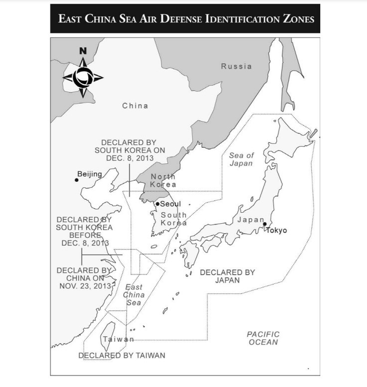
ADIZs have been established in North Asia by the People’s Republic of China (PRC), Taiwan, South Korea, and Japan. The PRC ADIZ differs from the others in that it intentionally overlaps portions of the other three. The PRC ADIZ also includes the airspace above Japanese administered territory16 and appears to assert jurisdiction over international air space.17  (The People’s Republic of China AIP can be accessed here.)18

The PRC declared an ADIZ in the East China Sea on November 23, 2013.19 This ADIZ differs from other zones because claims to apply to all aircraft transiting the zone whether or not they intend to enter PRC national airspace. Such a requirement is inconsistent with international law.20 The zone requires all aircraft transiting through the zone “to follow identification rules, including filing a flight plan with the PRC’s Ministry of Foreign Affairs or Civil Aviation Administration; maintaining two-way radio communications and responding promptly to identification requests from the Ministry of National Defense; operating a secondary radar responder (if equipped); and marking nationalities and logos clearly.”21 The zone therefore illegally purports to assert PRC jurisdiction over aircraft in international airspace.22 Under international law, all transiting aircraft are guaranteed freedom of overflight in international airspace seaward of the territorial sea.

The PRC zone directly overlaps with those of Taiwan, South Korea, and Japan.23 This was the first ADIZ to intentionally overlap with another.24 It also includes airspace over the Japanese-administered Senkaku Islands adjacent to Taiwan. These islands are the subject of a territorial dispute between the PRC/Taiwan and Japan.25

Both the United States and Japan protested the establishment of the ECS ADIZ. Then-U.S. Secretary of State John Kerry accused China of attempting to change the status quo in the East China Sea and increasing tensions in the region. The U.S. statement further indicated that the United States does not “support efforts by any state to apply its ADIZ procedures to foreign aircraft not intending to enter its national airspace.” Japan’s Minister of Foreign Affairs similarly accused China of attempting to change the status quo in the East China Sea, indicating that the ADIZ “measures unduly infringe the freedom of flight in international airspace…and will have serious impacts on the order of international aviation.” Japan also objected strongly to the inclusion of the airspace over the Senkaku Islands within the ECS ADIZ.

Name

Lateral Limits

Upper/Lower Limits and
system/means of activation announcement
INFO for CIV FLT
1 2
PRC ADIZ

3º11’N and 121º47’E , 33º11’N and 125º00’E, 31º00’N and 128º20’E, 25º38’N and 125º00’E, 24º45’N and 123º00’E, 26º44’N and 120º58’E

UNL / SFC
Figure 1: East China Sea Air Identification Zones

Taiwan’s ADIZ is defined in its AIP.26 The Taiwan ADIZ was established by the United States after the Second World War and applies the standard request for aircraft entering the zone intending to enter Taiwanese air space to identify themselves. Civil aircraft are required to fly above 4,000 feet along designated airways or as vectored by air traffic controllers. Aircraft that do not comply with these requirements are subject to intercept by military aircraft.27 Other examples for intercept include, “Aircraft deviat[ing] from the current flight plan – fail[uire] to pass over a compulsory reporting point within 5 minutes of the estimated time over that point; deviat[ing] 20 NM from the centerline of the airway; or 2000FT difference from the assigned altitude; or any other deviations.”28 Taiwan’s AIP publishes strict guidance for aircraft to “fly straight and level” upon interception and to take no action that might be viewed as hostile. Communication with the intruding aircraft will be attempted via radio or visual signals. The AIP notes that Taiwan will not be held responsible for damages caused by interception or failure to comply with ADIZ requirements. Since September 2020, Chinese military aircraft have maintained a near continuous presence in the Taiwan ADIZ, penetrating the zone nearly 2,200 times. Although China believes that these incursions are consistent with international law because Taiwan is part of China, Taiwan has stated that it will respond in self-defense if attacked.

Name

Lateral Limits

Upper/Lower Limits and
system/means of activation announcement
INFO for CIV FLT
1 2
Taiwan ADIZ
210000N 1173000E –
210000N 1213000E –
223000N 1230000E –
290000N 1230000E –
290000N 1173000E –
210000N 1173000E.
UNL / SFC

The South Korean ADIZ is described in its AIP.29 The ADIZ was established in 1951 by the U.S. Air Force during the Korean War. It currently includes airspace above Ieodo/Suyan, a submerged feature disputed between South Korea and the PRC. South Korea expanded its ADIZ to include the airspace over Ieodo in December 2013 after the PRC included the airspace above the feature in its ADIZ in November 2013.30 The Korean ADIZ is similar to the PRC ADIZ in that it requires aircraft flying in the zone to submit a flight plan whether or not they intend to enter Korean air space. Aircraft are required to maintain two-way radio contact, use a secondary surveillance radar transponder, and make position reports every thirty minutes to air traffic control. 

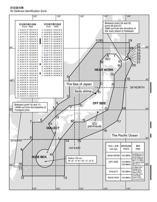
An illustration of Japan’s ADIZ is contained in its AIP.31 Japan’s ADIZ was established in 1969. It does not include the airspace above the disputed Northern Territories/Kuril Islands controlled by Russia.32 The Japanese ADIZ follows the North American example applying its procedures only to aircraft intending to enter Japanese national airspace. The zone is divided into an inner and outer zone. The inner zone overlaps the territorial Sea of Japan. An aircraft entering the inner zone is expected to file a flight plan in advance and comply with air traffic control instructions or face interception.

Name and lateral limits Upper limit / Lower limit
1 2
KOREA ADIZ(KADIZ)

3900N 12330E – 3900N 13300E-

3717N 13300E – 3600N 13030E-

3513N 12948E – 3443N 12909E-

3417N 12852E – 3230N 12730E-

3230N 12650E – 3000N 12525E-

3000N 12400E – 3700N 12400E-

3900N 12330E

UNL/SFC
Figure 2: Air Defense Identification Zone of Japan

Conclusion

While ADIZs may have once been a relic of the Cold War, the situation in the East China Sea has seen an increase in their use. As the issue of China-Taiwan relations remains unresolved, the PRC ADIZ might become a tool to pressure other nations if the PRC chooses to assert sovereignty over the ADIZ by intercepting civil aircraft over the ECS. Certainly for Taiwan, repeated instances of Chinese military aircraft testing Taiwan’s response time show that ADIZs will remain relevant for the foreseeable future.

LtCol Brent Stricker, U.S. Marine Corps, serves as the Director for Expeditionary Operations and as a military professor of international law at the Stockton Center for International Law at the U.S. Naval War College. The views presented are those of the author and do not necessarily reflect the policy or position of the U.S. Marine Corps, the U.S. Navy, the Naval War College, or the Department of Defense.

Endnotes

1. Convention on International Civil Aviation, Oct 13, 1919, 11 LNTS 174, reprinted in 17 AJIL Supp. 195 (1923) (no longer in effect).

2. Peter A. Dutton, “Caelum Liberum: Air Defense Identification Zones outside Sovereign Airspace” The American Journal of International Law, Vol. 103, No. 4 (Oct., 2009), pp. 691-709, 692.

3. Chicago Convention Article 3.

4. Id.

5. INT’L Civil Aviation Organization, Convention on International Civil Aviation, Annex 15, International Standards and Recommended Practices, Aeronautical Information Services (16th ed. July 2018). .

6. For a comprehensive listing of AIPs see Hazy Library Emory Riddle Aeronautical University Unmanned Aircraft Systems (UAS) Resources: Electronic AIPs by Country (https://erau.libguides.com/uas/electronic-aips-country).

7. James Kraska and Raul Pedrozo International Maritime Security Law 158 (2013); Raul “Pete” Pedrozo, “Air Defense Identification Zones” 97 INT’L L. STUD. 7, 8 (2021).

8. Joëlle Charbonneau, Katie Heelis, and Jinelle Piereder, “Putting Air Defense Identification Zones on the Radar” Centre for International Governance Innovation POLICY BRIEF No. 1 • June 2015 CIGI Graduate Fellows Series at 2

9. J Ashley Roach “Air Defense Identification Zones” Max Planck Encyclopedia of Public International Law www.mpepil.com, https://opil-ouplaw-com.usnwc.idm.oclc.org/view/10.1093/law:epil/9780199231690/law-9780199231690-e237; Each country’s ADIZ is defined in its own Aircraft Information Publication (AIP). Joëlle Charbonneau, Katie Heelis, and Jinelle Piereder, “Putting Air Defense Identification Zones on the Radar” Centre for International Governance Innovation POLICY BRIEF No. 1 • June 2015 CIGI Graduate Fellows Series at 4.

10. J Ashley Roach “Air Defense Identification Zones” Max Planck Encyclopedia of Public International Law www.mpepil.com, (https://opil-ouplaw-com.usnwc.idm.oclc.org/view/10.1093/law:epil/9780199231690/law-9780199231690-e237).

11. J Ashley Roach “Air Defense Identification Zones” Max Planck Encyclopedia of Public International Law www.mpepil.com, (https://opil-ouplaw-com.usnwc.idm.oclc.org/view/10.1093/law:epil/9780199231690/law-9780199231690-e237).

12. Chicago Convention Article 3.

13. Oliver J. Lissitzyn “Legal Implications of the U-2 and RB-47 Incidents” The American Journal of International Law Jan 1962, Vol 56, No.1 pp. 135-142. (https://www.cambridge.org/core/journals/american-journal-of-international-law/article/some-legal-implications-of-the-u2-and-rb47-incidents/EF3BFC9B45E842B3A5B298D120DBE241).

14. Lissitzyn at 141 (https://www.cambridge.org/core/journals/american-journal-of-international-law/article/some-legal-implications-of-the-u2-and-rb47-incidents/EF3BFC9B45E842B3A5B298D120DBE241).

15. Lissitzyn at 142 (https://www.cambridge.org/core/journals/american-journal-of-international-law/article/some-legal-implications-of-the-u2-and-rb47-incidents/EF3BFC9B45E842B3A5B298D120DBE241).

16. Joëlle Charbonneau, Katie Heelis, and Jinelle Piereder, “Putting Air Defense Identification Zones on the Radar” Centre for International Governance Innovation POLICY BRIEF No. 1 • June 2015 CIGI Graduate Fellows Series at 4.

17. “Strauss at 759; “Announcement of the Aircraft Identification Rules for the East China Sea Air Defense Identification Zone of the P.R.C.,” PRC Ministry of National Defense, November 23, 2013, (http://eng.mod.gov.cn/Press/2013-11/23/ content_4476143.htm).

18. To access the PRC AIP (https://www.aischina.com/EN/indexEn.aspx).

19. Ted Adam Newsome, “The Legality of Safety and Security Zones in Outer Space: A Look to Other Domains and Past Proposals” A thesis submitted to McGill University in partial fulfillment of the requirements of the degree of MASTER OF THE LAWS (LL.M.) Institute of Air and Space Law McGill University, Faculty of Law Montreal, Quebec August 2016 at 47.

20. “Pedrozo at 9-10.

21. Edmund J. Burke and Astrid Stuth Cevallos, In Line or Out of Order? China’s Approach to ADIZ in Theory and Practice 6-7 (2017).

22. Edmund J. Burke and Astrid Stuth Cevallos, In Line or Out of Order? China’s Approach to ADIZ in Theory and Practice 7 (2017).

23. Raul “Pete” Pedrozo, “China’s Legacy Maritime Claims” Lawfare (July 15, 2016) (https://www.lawfareblog.com/chinas-legacy-maritime-claims).

24. Raul “Pete” Pedrozo, “China’s Legacy Maritime Claims” Lawfare (July 15, 2016) (https://www.lawfareblog.com/chinas-legacy-maritime-claims).

25. Edmund J. Burke and Astrid Stuth Cevallos, In Line or Out of Order? China’s Approach to ADIZ in Theory and Practice 1 (2017).

26. To access Taiwan’s AIP (https://eaip.caa.gov.tw/eaip/home.faces).

27. NR 1.12 Taiwan AIP.

28. NR 1.12 Taiwan AIP.

29. To access the South Korea AIP (https://aim.koca.go.kr/aim/main.do).

30. Michael Strauss “China-Japan-South Korea-Taiwan: East China Sea Air Defense Identification Zones” Border Disputes : A Global Encyclopedia: Functional Disputes, 2015, p.759-764, 761.

31. To access Japan’s AIP (https://aisjapan.mlit.go.jp/Login.do).

32. Edmund J. Burke and Astrid Stuth Cevallos, In Line or Out of Order? China’s Approach to ADIZ in Theory and Practice 5 (2017).

Featured Image: U.S. Air Force, Navy, Marine Corps and Air Self-Defense Force aircraft conduct a large-scale joint and bilateral integration training exercise on Tuesday in airspace near Japan. (U.S. Air Force photo)

Civilian Shipping: Ferrying the People’s Liberation Army Ashore

By Michael Dahm and Conor M. Kennedy

The Peoples Liberation Army (PLA) has been increasing its ability to use civilian roll-on/roll-off (RO-RO) ferries to move troops and equipment ashore in amphibious landing operations. In August 2020, the PLA conducted a cross-sea mobility evolution using RO-RO ferries. Exercise Eastern Transportation-Projection 2020A (东部运投—2020A) was unique in that it discharged military vehicles from RO-RO ferries directly onto a beach using a modular floating pier. Commercial satellite imagery of a PLA amphibious exercise area in late-summer 2021 revealed that the PLA may have developed an improved floating pier system to support amphibious operations.  These capabilities, components of what the U.S. Navy calls “joint logistics over-the-shore (JLOTS),” allows the PLA to use civilian vessels to move large amounts of military equipment into unimproved amphibious landing areas without port infrastructure. A Chinese mobile pier system like those observed in these exercises may have particular application for the PLA in an invasion of Taiwan. 

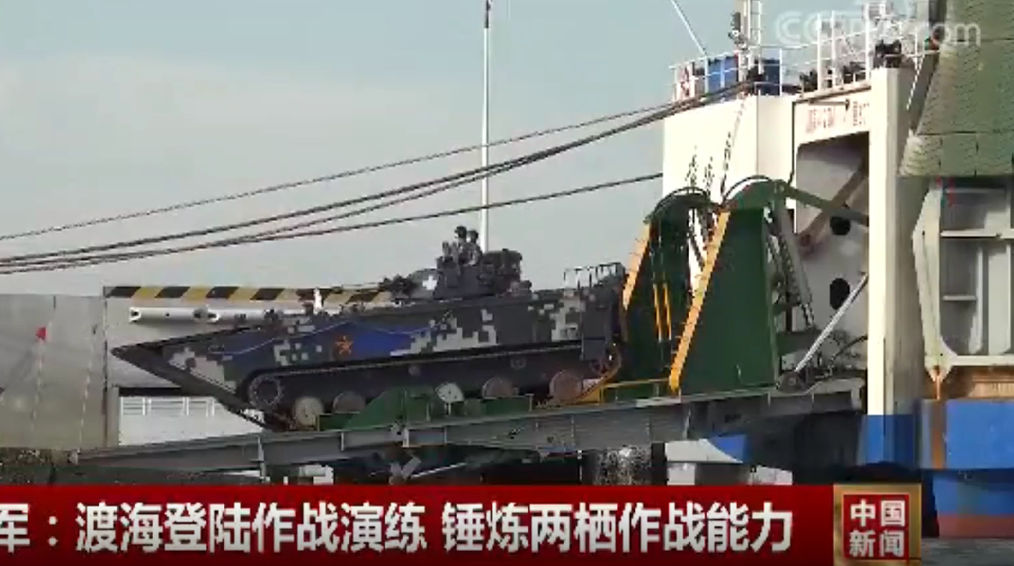
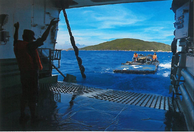
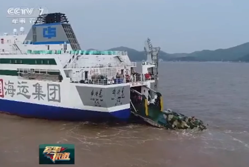
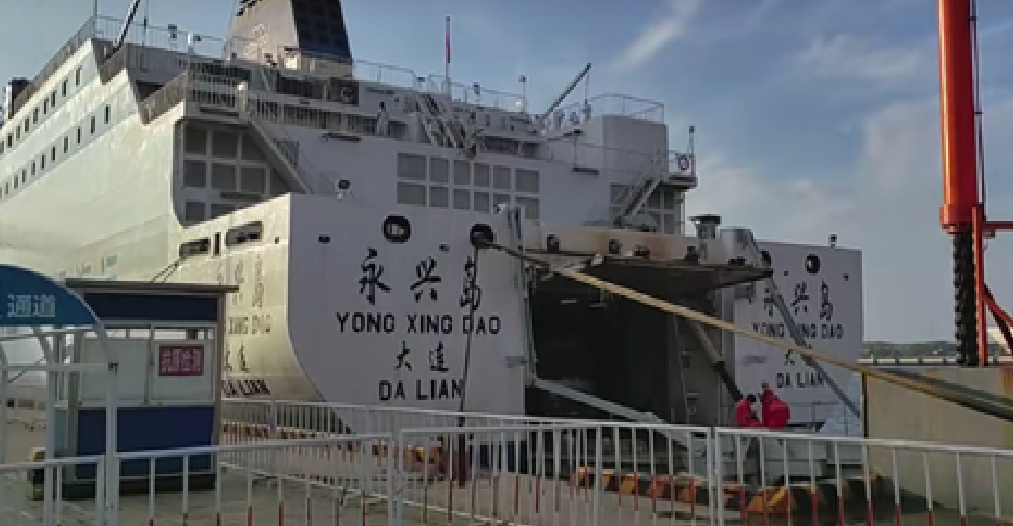
The PLA has been using civilian transportation capabilities for military mobility for many years, moving military forces and equipment up and down the Chinese coast. RO-RO ferries provide significant capacity to move armor and other rolling stock. Recent PLA innovations are enabling greater roles for civilian ferries to move forces ashore. For example, some Chinese civilian ferries have been retrofitted with capabilities to deploy amphibious armored vehicles at-sea, essentially making them auxiliary amphibious landing ships. This is likely meant to compensate for the apparent shortage in PLA amphibious lift required to conduct a cross-strait landing. The PLA appear to be learning from their American counterparts with solutions for moving forces and supplies ashore in the absence of port infrastructure. This article explores a novel floating pier system that may provide a solution to some of the PLA’s amphibious lift shortcomings.

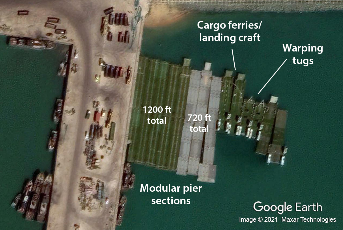
What the Chinese call an “offshore mobile debarkation platform” (海上机动卸载平台) was spotted in commercial satellite imagery along the fishing wharves of the Lanshan District in Rizhao City, China in September 2020. A PLA 2007 patent application for a similar system indicates sections include “square” or intermediate pontoon modules (方形模块), bow-stern modules (首尾模块), ramp modules (坡道模块), powered modules (推进模块), cargo ferries (货运渡船) and lighters (驳船) as well as warping tugs (绞滩拖船) to maneuver the different sections. The floating pier system was developed by engineers at the PLA Military Transportation University in Tianjin.

Chinese modular floating pier system in port Lanshan, China, September 27, 2020 (Google Earth, Image © Maxar Technologies 2021)

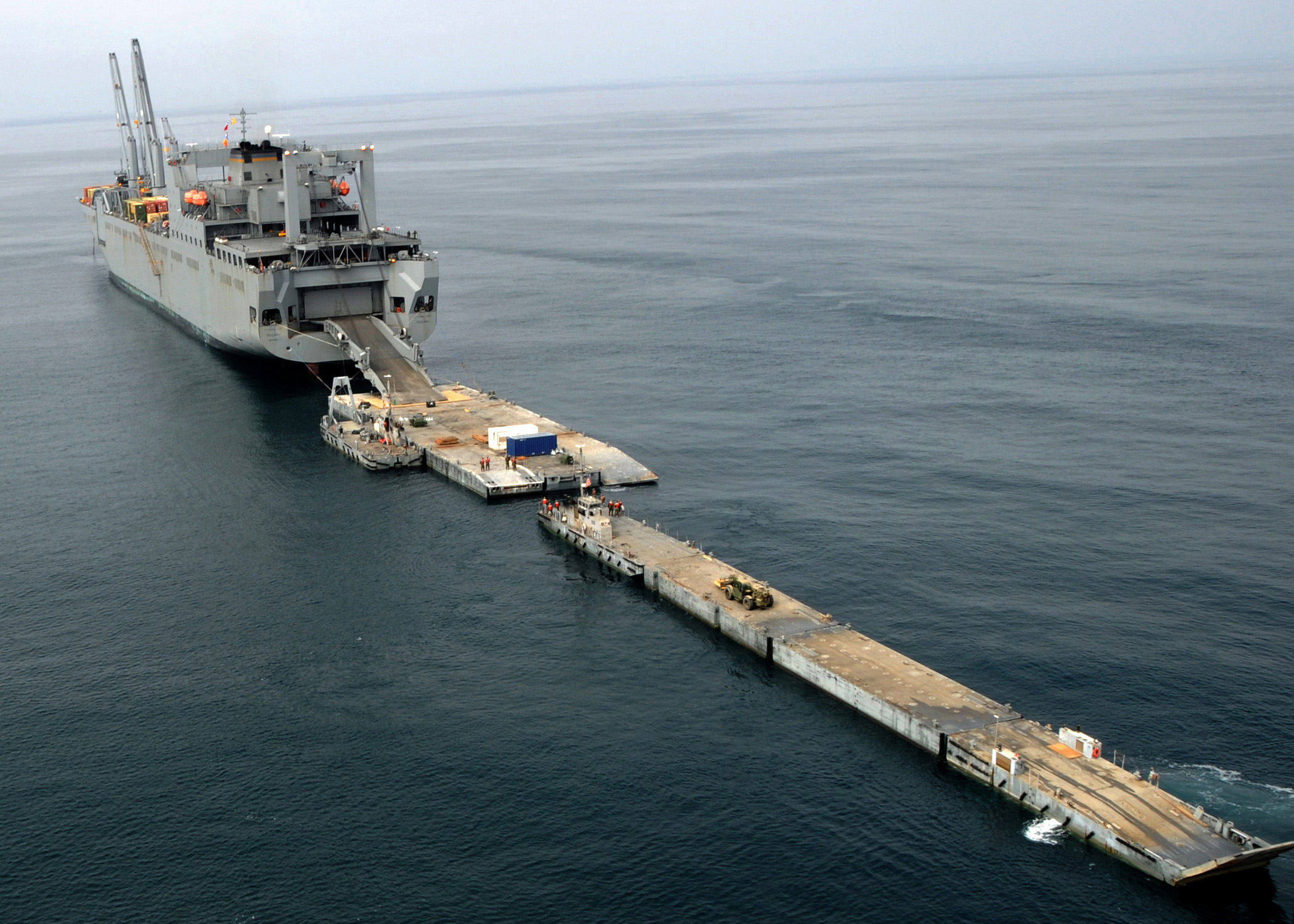
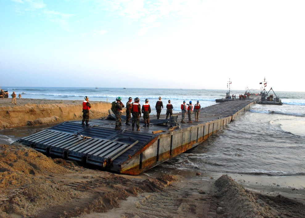
The Chinese system looks very similar to the U.S. Navy’s Improved Navy Lighterage System (INLS), produced by the Fincantieri Marine Group.  The INLS is used principally by U.S. Navy Maritime Prepositioning Force (MPF) ships. The system appears to have the same types of interchangeable modules as the U.S. floating causeway system. The U.S. system is used for off-loading MPF ships miles off-shore and then floating equipment and cargo to the beach. Alternatively, the INLS can be employed as a floating pier as shown in the images below from Exercise JLOTS 2008 off Camp Pendleton, California.

 USNS Pililaau (T-AKR 304) with INLS in U.S. Exercise JLOTS 2008 (U.S. Navy Photo, MC2 Caracci)
 INLS employed as temporary pier in U.S. Exercise JLOTS 2008 (U.S. Navy Photo, MC3 Morales)

China’s National Defense Mobilization Committee ordered development of an offshore mobile debarkation platform for the PLA in 2001. The system was one of the major focus areas under “Project 019” (019工程), an effort to resolve issues of vehicle and materiel lightering when port infrastructure is unavailable or degraded by “blue forces.” A team of engineers at the PLA’s Military Transportation University worked for over a decade to overcome the engineering challenges associated with the system, especially as they related to connections between the modules and shallow water propulsion. Chinese media reports indicate the system has been used in exercises since 2012, but trials likely began earlier.

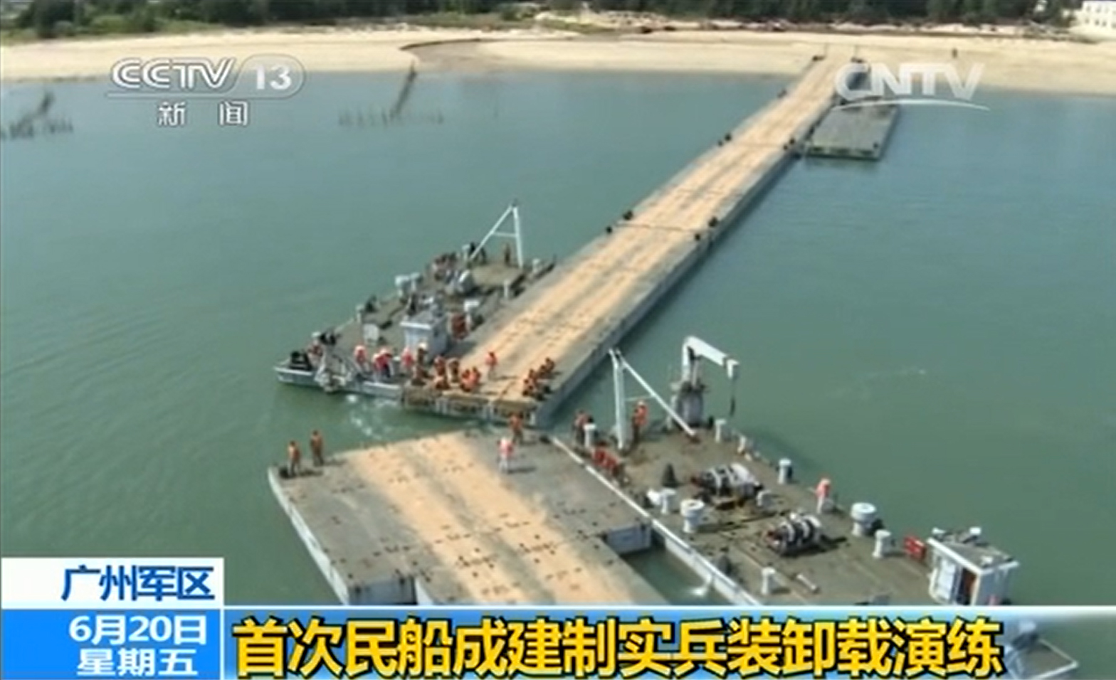
The offshore mobile debarkation system was featured in news coverage of a 2014 Guangzhou Military Region (GZMR) exercise. This was reportedly the first time the PLA used a civilian, militia-operated RO-RO ferry to embark and offload a PLA unit using the system.  The 2014 exercise took place in the southern port city of Zhanjiang where an unidentified PLA mechanized infantry company (机械化步兵连) was loaded onto the Nan Fang 6, a commercial RO-RO ferry that normally provides service between the mainland and Hainan Island.  As part of the exercise scenario, the ferry was told its destination terminal had been damaged and was ordered to offload over the beach. According to the news report, the PLA dispatched and assembled a “sectional causeway” (拼装式栈桥) system to a beach landing area. Warping tugs were shown assembling five pontoon units, extending the floating causeway approximately 600 feet from the shore.

Chinese offshore mobile debarkation system assembled in 2014 exercise in Zhanjiang, China (CCTV)

Interestingly, a semi-submersible barge, often used in port construction projects, was placed at the end of the causeway to act as the pier head. With a ramp leading to the causeway, the semi-submersible barge could raise or lower its height above the water to accommodate different size RO-RO vessels.

Semi-submersible barge used with offshore mobile debarkation system in 2014 exercise (CCTV)

After the RO-RO ferry docked with the semi-submersible barge, PLA equipment and troops immediately began to stream out of the ship. Reporters stated that the sectional causeway was assembled in just under an hour, a boast that seems somewhat implausible. The GZMR military transportation department director told reporters the floating causeway fixed “a number of bottlenecks in carrying out maritime projection with civilian ships.” There have been few other publicized training events using this system since the 2014 exercise. Prototypes of this system may have seen improvements by PLA engineers over the years, but its basic concept of operation appears to have remained the same.

Civilian ferry off-loading armored vehicles to beach in 2014 exercise (CCTV)

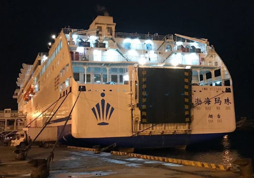
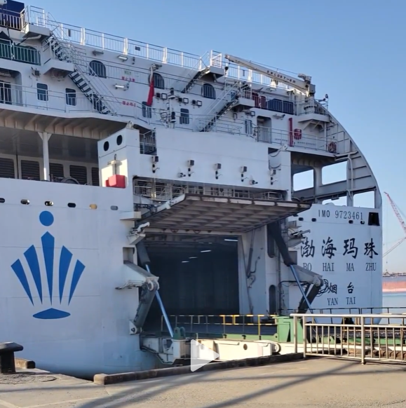
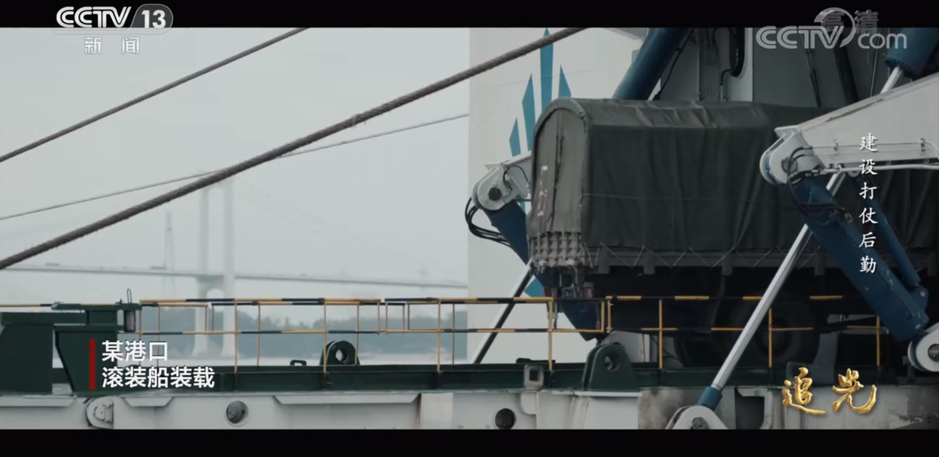
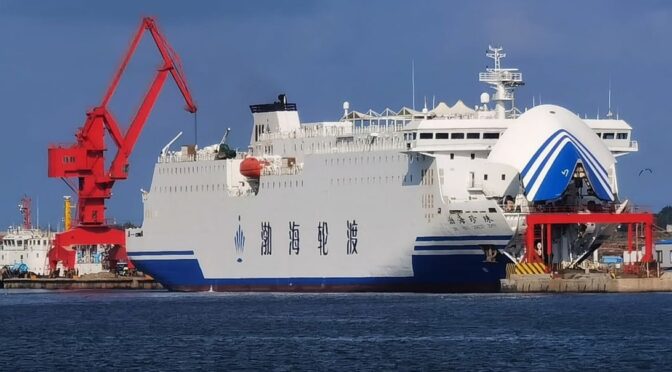
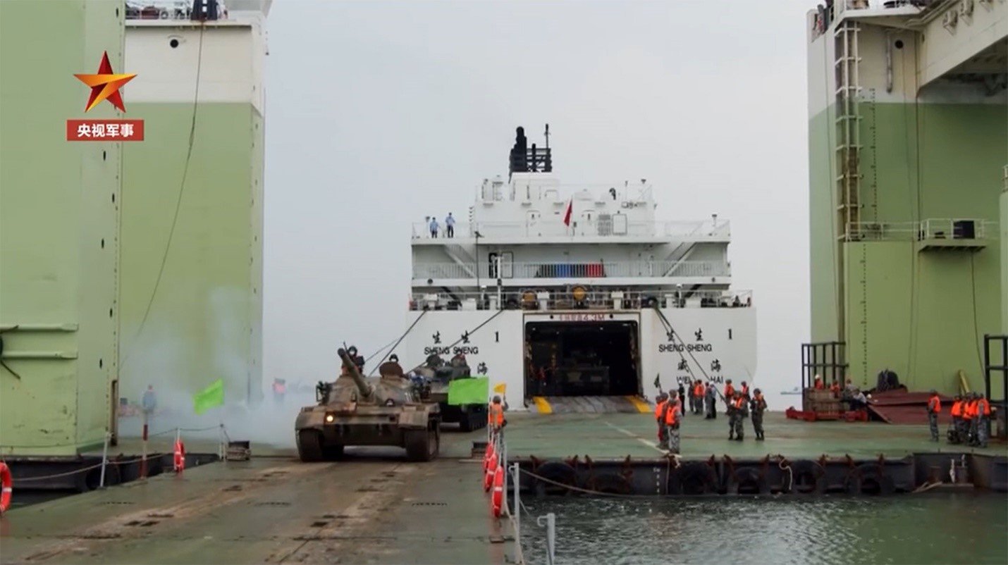
A Chinese television report on the August 2020 PLA exercise Eastern Transportation-Projection 2020A shows army equipment being loaded onto civilian ships in the port of Lianyungang. Footage showed the port’s container cranes loading trucks and other military cargo into the 322 foot general cargo ship Sheng Tai. At the nearby ferry terminal, PLA armored and wheeled vehicles were loaded aboard the Sheng Sheng 1, a 394 foot, 10,000 ton RO-RO ferry as well as the much larger Bohai Baozhu (Bohai Pearl) a 535 foot, 24,000 ton RO-RO ferry. Like most newer Chinese-flagged ferries, the Bohai Baozhu was built to national defense specifications for carrying military equipment.  The Bohai Baozhu is owned by the Bohai Ferry Group (渤海轮渡股份有限公司), which operates eleven RO-RO ferries in the Bohai Gulf. The company’s ships have been organized into the “Eighth Transport Dadui” (海运八大队), part of the PLA’s strategic projection support ship fleet (战略投送支援船队). The Sheng Sheng 1 is seen briefly at the end of the television report offloading tanks onto the semi-submersible barge and onto the offshore mobile debarkation system.  The Sheng Sheng 1 was also seen in the July 14, 2020 high-resolution Planet Labs SkySat image, below, preparing to back into the same semi-submersible barge attached to the floating pier.

Civilian ferry Sheng Sheng 1 off-loading tanks onto semi-submersible barge and offshore mobile debarkation system in the 2020 exercise (CCTV)
Sheng Sheng 1 maneuvering for a stern docking with the semi-submersible barge and floating pier (Includes content sourced via SkyWatch Space Applications Inc., Powered by Planet – SkySat Image © Planet Labs 2021)

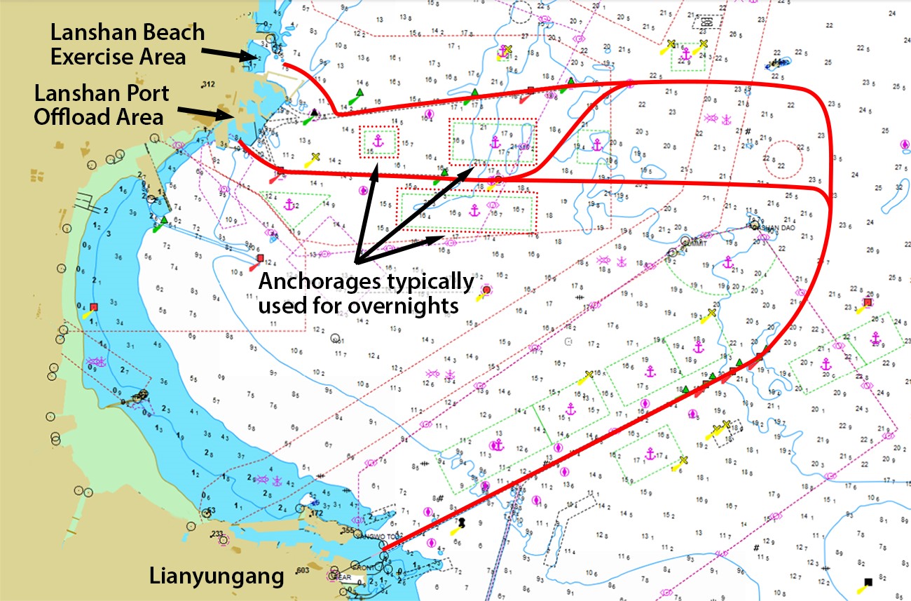
A soon-to-be published paper presented at a recent conference on PLA amphibious operations hosted by the U.S. Naval War College’s China Maritime Studies Institute provides a comprehensive account of the 2020 exercise. Two dozen commercial ships, tugs, and military landing craft took part in the large-scale operation led by the PLA’s Joint Logistics Support Force. According to ship automatic identification system (AIS) tracks, RO-RO ferries and cargo vessels sailed from the embarkation port of Lianyungang 24 nautical miles north to Lanshan. According to Chinese media reports, just as in the 2014 Zhanjiang exercise, a major component of the exercise involved ferries off-loading using a semi-submersible barge and a floating pier.  Civilian ferries like the Bohai Baozhu and the Sheng Sheng 1 made several trips between Lianyungang and Lanshan, apparently transporting military equipment in each run before then returning to civilian ferry service across the Bohai Gulf. 

Typical tracks of exercise ships during Eastern Transportation-Projection 2020A (Supported with AIS data from MarineTraffic – Global Ship Tracking Intelligence, www.marinetraffic.com)

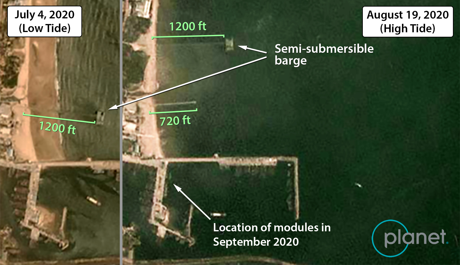
The Chinese offshore mobile debarkation system is large enough to be seen in lower resolution Planet Labs commercial satellite imagery acquired between June and August 2020.  The Lanshan beach area imaged is just north of the fishing wharf where the pier modules were imaged in September 2020.  The floating pier was set up and taken down several times over two months, each time with the semi-submersible barge attached or close by off-shore. The temporary piers in the Planet Labs images correspond to the lengths of the system seen in the much higher-resolution Google Earth/Maxar image – approximately 1200 feet for the green pontoon sections and 720 feet for the grey pontoon sections. The shorter floating pier was used throughout the course of the exercise for landing craft that were off-loading cargo ships and other ferries farther off-shore. Planet Labs imagery indicates the modular system remained in Lanshan until November 2020. Its current location is unknown.

Offshore mobile debarkation system moved to several locations during the 2020 exercise (Powered by Planet – PlanetScope Image © Planet Labs 2021)

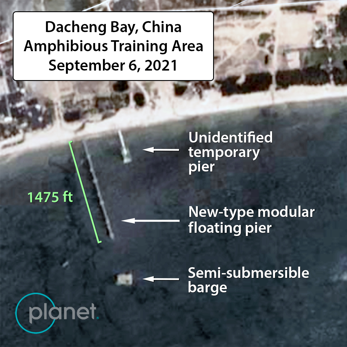
In late-August and early-September 2021, a new modular pier system was spotted in commercial satellite imagery at a known PLA amphibious training area in Dacheng Bay, China near the southern end of the Taiwan Strait.  This improved system bears a closer resemblance to the U.S. Navy INLS.  It is much more substantial and longer than the older floating pier, extending approximately 1475 feet from the shore. According to AIS tracks, two Bohai Ferry Group ships, the Boahai Mazhu and the Bohai Cuizhu visited the Dacheng Bay amphibious training area on September 4, 2021, probably to off-load dozens of ten-man assault boats in support of an amphibious raid. One significant indicator of floating pier operations in the exercise area was the presence of the same semi-submersible barge that was used in the summer 2020 exercise, the Sanhanggong 8, operated by the state-owned China Communications Construction Company (CCCC).  The new floating pier system, the semi-submersible barge and an unidentified temporary pier may be seen in the low-resolution satellite image, below. Analysis of this exercise and its use of civilian shipping is on-going.

New-type modular floating pier observed at PLA’s Dacheng Bay amphibious training area in September 2021 (Powered by Planet – PlanetScope Image © Planet Labs 2021)

Beyond the media reports of the 2014 exercise and the 2020/2021 exercises, there is little open-source reporting available on the PLA’s use of these sectional causeways. It is interesting to note that in each example, the system was deployed in relatively sheltered areas with calm waters. The original Chinese patent for the system indicates it can operate in sea state 3 (wave heights up to 4 feet), which is identical to the advertised operating limit of the U.S. Navy INLS.

The Chinese offshore mobile debarkation system, while not as striking as the Chinese Navy’s newest amphibious assault ships, may have greater implications for how the PLA projects power over-the-shore, especially in a cross-strait amphibious invasion of Taiwan. Any large-scale landing by PLA Navy amphibious assault ships will require significant maritime lift for second echelon forces and logistics. This modular pier system may allow China’s substantial fleet of large civilian RO-RO ships to offload combat troops and equipment directly onto Taiwan’s beaches. Proficiency with this system and other JLOTS capabilities will be a critical capability in a cross-strait invasion if the PLA is unable seize Taiwan’s port infrastructure intact.      

Michael Dahm is a senior researcher at the Johns Hopkins University Applied Physics Laboratory (APL) and retired U.S. Navy intelligence officer. His research focuses on foreign military technologies and operational concepts.

Conor Kennedy is a research associate at the U.S. Naval War College, China Maritime Studies Institute. His research focuses on Chinese military development and maritime strategy.

The analyses and opinions expressed in this paper are those of the authors and do not necessarily reflect those of the U.S. Navy, the U.S. Naval War College, the Johns Hopkins University Applied Physics Laboratory (APL) or APL sponsors. Commercial satellite images are sourced via SkyWatch Space Applications Inc. and Planet Labs, Inc. and are published under license from Planet Labs, which retains copyrights to the original, underlying images. This work has also been supported with AIS data from MarineTraffic – Global Ship Tracking Intelligence (www.marinetraffic.com).

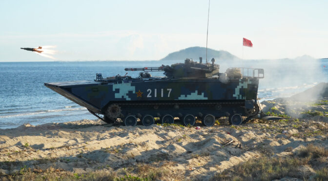
Featured Image: An amphibious infantry fighting vehicle attached to a brigade of the PLA Navy Marine Corps launches anti-tank missiles during a maritime live-fire training exercise in mid July, 2021. (eng.chinamil.com.cn/Photo by Liu Yuxiang)

Leviathan Wakes: China’s Growing Fleet of Autonomous Undersea Vehicles

Emerging Technologies Topic Week

By Ryan Fedasiuk

Since 2018, Indonesian fishermen have regularly reeled in autonomous, glider-like vehicles operating as far south as the Java Sea—part of China’s longstanding undersea vehicle research program first declassified in 2021. Over the past decade, details have sporadically emerged about China’s unmanned (UUV) and autonomous undersea vehicle (AUV) projects, but questions linger about which kinds of vessels the Chinese defense industry may be developing, and how the People’s Liberation Army (PLA) might use them in a future conflict.

This article draws on a wide array of primary sources—including advertisements from defense companies, PLA writings and research papers, and information released by state-run research institutes—to illuminate China’s growing fleet of autonomous undersea vehicles. After profiling three major AUV research institutes, the article identifies potential applications of China’s growing fleet of AUVs and continued barriers to development.

China’s Big Three Undersea Vehicle Developers

As in many other Chinese technology industries, the state plays a leading role in undersea vehicle development. In 1986, Chinese Premier Zhao Ziyang initiated the State High-Tech Development Plan (863 Plan) to fund billions of dollars in applied technology development. In 1996, marine technologies were added to the program, adding further fuel to China’s emerging undersea vehicle industry. In particular, three government-sponsored research institutions form the backbone of AUV development in China. Each began undersea vehicle research in the 1980s, and has gone on to pioneer lines of AUVs still in use today:

Shenyang Institute of Automation. Part of the Chinese Academy of Sciences, SIA’s Computer Vision Group (机器人视觉组) is at the forefront of state-backed unmanned technology and autonomy research in China. In 1981, SIA developed the HR-01, China’s first remotely-piloted undersea vehicle. The institute went on to develop the “Explorer” (探索者) series of fully autonomous undersea vehicles in the 1990s and 2000s, with later variants capable of diving to 6,000 meters. Today, SIA specializes in developing prototypes of medium and large undersea vessels, including the Sea-Whale 2000 (海鲸2000) and Qianlong (潜龙; “Hidden Dragon”) series of AUVs.

China Shipbuilding Industry Corporation. As the world’s largest shipbuilding conglomerate, CSIC’s myriad research institutes have made significant contributions to China’s AUV research and development, particularly the 701, 702, 710, and 714 Research Institutes. Since 2000, CSIC has been responsible for developing the Haishen (海神; “Poseidon”) series of AUVs, in addition to a new line of autonomous undersea gliders, such as the Haiyi 1 (海翼一号; “Sea Wing”).

Harbin Engineering University. Originally called the Harbin Institute of Shipbuilding, HEU began developing a “Smart Water” (智水) series of AUVs in 1991, and has gradually expanded AUV testing in the South China Sea. The Smart Water series today comprises five variants of different sizes, but HEU has developed additional AUV models for undersea surveying and mapping, such as the Weilong (微龙; Microdragon) 1, 2, and 3. HEU is also home to China’s State Key Laboratory of Underwater Vehicle Technology (水下航行器信息技术重点实验室), which specializes in developing human-occupied, remotely-operated, and autonomous surface and deep-sea vehicles.

New Players in AUV Development

Beyond China’s big three AUV design centers, a growing number of research institutes and private enterprises are entering the Chinese AUV market. A document published in 2019 by the Chinese Society of Naval Architecture lists 159 undersea vehicle research projects under development at more than 40 Chinese universities—a significant increase over the 15 major universities that had constructed undersea vehicle research teams just four years prior. Another document prepared by Dr. Wu Jianguo, a professor at Hebei University of Science and Technology, shows that more than 48 universities and 45 enterprises in China host major UUV and AUV projects.

The CCP’s military-civil fusion (军民融合) development strategy is also facilitating a boom in China’s private-sector AUV industry. By promoting resource and information sharing between the military and private technology companies, China has seen some success in its efforts to accelerate AUV research, as several enterprises are developing new lines of AUVs independent of the big three research institutes. While it is too early to say whether they may become globally competitive with companies like the U.S.-based Bluefin Robotics or Norway’s Kongsberg, Chinese enterprises such as Xi’an Tianhe Haiphong Intelligent Technology (西安天和海防智能科技) and Startest Marine (星天海洋) seem to be emerging as China’s national champions of AUV systems and equipment. In 2017, China’s International Ocean Technology Exhibition in Qingdao attracted representatives from more than 500 enterprises working on AUV systems and components.

How the PLA Navy Might Use Autonomous Undersea Vehicles

While China’s AUV fleet still primarily consists of early-stage research experiments and prototypes, scientific research papers and theoretical writings by the PLA Navy (PLAN) indicate that it is primarily interested in using AUVs for marine surveying and reconnaissance, mine warfare and countermeasures, undersea cable inspection, and anti-submarine warfare. Each of these applications rely on different AUV models, and carry distinct implications and risks for the U.S. Navy and its partners in the Indo-Pacific.

Marine Surveying and Reconnaissance

The PLAN’s most mature application of AUVs is in marine surveying and reconnaissance. Chinese and American analysts have long assessed that the United States would retain a significant undersea advantage in a Taiwan Strait contingency, and the PLAN has rapidly expanded its manned diesel submarine force to compensate for this disadvantage. As early as 2013, the PLA commissioned construction of the Great Underwater Wall (水下长城), a network of hydrosonic sensors deployed at depths of 2,000 meters, which are designed to detect adversary undersea vehicles operating in the South China Sea. More recent research papers indicate that the PLAN may field groups of small and medium-sized AUVs for a similar purpose.

Portable and light models have so far formed the backbone of the PLAN’s emerging AUV fleet—in part due to battery constraints. Early AUV prototypes, such as CSIC’s Haishen 100 (海神100; “Poseidon 100”) and SIA’s Explorer (探索者), could dive to less than 1000 meters each; but modern variants have grown both in size and capability. Undersea gliders are a particularly promising innovation, and it is no surprise that so many have been found across the Indo-Pacific: Because of their improved range and endurance, gliders can more reliably detect undersea objects and periodically surface to transmit that information to ground stations and surface vessels. In the event of a crisis, analysts warn that autonomous gliders could be used to overcome China’s significant disadvantage in undersea warfare by detecting and tracking the locations of U.S. submarines even beyond the first island chain. Examples of such vehicles include SIA’s Haiyi (海翼; Sea Wing); Tianjin University’s Haiyan (海燕; Sea Swallow); and the Hai Xiang (海翔; Sea Flyer) developed by CSIC’s 702 Research Institute. Still, that gliders must surface in order to transmit information to one of three intelligence processing centers offers a point of vulnerability, and Chinese experts still believe the United States has an advantage in undersea surveying and mapping.

Figure 1. “Marine Environment Detection by Underwater Glider” Source: CSIC 714 Research Institute.

Mine Warfare and Countermeasures

Sea mines are a core tenet of Chinese naval doctrine and planning. As early as 2013, researchers at the China Engineering Science and Technology Forum publicly acknowledged the significance of UUVs in deploying mines and mine countermeasures (MCM); and military analysts have commented on the potential mine-laying capabilities of China’s HSU001 large-displacement UUV first unveiled in 2019. Today, the PLA may choose from more than 26 variants of floating and submerged mines designed to attack all manner of enemy ships and submarines.

Many of the PLA’s undersea mines are produced by CSIC’s 710 Research Institute—which also produces UUVs. Research published by the 710 Institute recommends developing AUVs and UUVs for minelaying and reconnaissance, but public information about the PLA’s current AUV models is scarce. One research paper published in August 2020 concludes that, “With the transformation of our navy’s strategy, the scope of anti-mine operations will extend to waters beyond the first island chain.” Some scholars believe that the PLAN could field more than 50 mines for each manned submersible—a feat that may eventually be possible for unmanned vehicles, too, as the Chinese AUV industry develops larger and larger vehicles. Examples of mid- and large-sized platforms include SIA’s Qianlong 1 and 2, and the Haishen series of UUVs developed by CSIC’s 701 Research Institute.

Figure 2. Haishen Series of AUVs. Source: Hebei University of Science and Technology.

Undersea Cable Inspection

Advances in unmanned vehicle research may also permit the PLAN to use AUVs to tap or sever undersea fiber-optic cables in a conflict, which concentrate near northern Taiwan. These cables are crucial not just for information dissemination in Taiwan, but also the trans-Pacific data exchanges that facilitate global internet access—including in some parts of the United States. HEU, for example, advertises AUVs for “underwater engineering investigation and maintenance,” including pipeline inspection and repair. Research papers and procurement records published by the PLA indicate that it may outfit undersea vehicles with robotic arms and sensors to interact with undersea cables. Some units have expressed an interest in procuring “SPICE,” a UUV produced by Kawasaki, which comes equipped with a robotic arm to repair undersea cables and pipelines.

Seabed Operations and Anti-Submarine Warfare

In the future, the Chinese military may use large AUV models for anti-submarine warfare (ASW) and operations near the seabed. Trends among PLAN research publications suggest that it is building signature libraries for undersea target detection and recognition, and several PLA units have awarded research contracts related to deep learning-based image recognition and target identification systems for undersea vehicles. In particular, students and researchers at HEU have pioneered an AI-based “seabed image mosaic system” for sonar image processing. Undersea target recognition systems like this could prove useful in autonomously identifying and interacting with sea floor infrastructure and other submarine vehicles.

Large AUVs may also be outfitted with weapons to engage adversary submarines. To date, the Chinese defense industry has produced few large AUV models suitable for ASW, although the number is growing. One notable example is the HSU-001, a large-displacement vehicle that sports side-scanning sonar arrays and a magnetic anomaly detector. Other medium and large AUV prototypes set records for depth and distance in 2020, including SIA’s Haidou 1 (海斗一号) and Sea-Whale 2000. Weighing in at more than 3.5 tons, China’s largest AUV so far is the Haishen 6000 (海神6000; “Poseidon 6000”), a 25 foot-long prototype developed by CSIC’s 701 Research Institute. The system is apparently capable of diving to depths of 6,000 meters, and comes equipped with “multiple detection devices such as an ultra-short baseline positioning system, an aircraft black box search sonar array, deep-sea side scanning sonar, an underwater camera, and forward-looking sonar.” Neither the HSU001 nor the Haishen 6000 appear to be outfitted with mine-laying rails or other weapon systems, but further advances in large AUV models and battery life could permit them to carry such payloads.

Figure 3. Haishen 6000, China’s Largest Known AUV. Source: CSIC 710 Research Institute.

Barriers to Chinese AUV Development

Despite its demonstrable progress in undersea detection and navigation, the Chinese AUV industry still faces significant technical and bureaucratic barriers to developing undersea platforms for military use.

The largest barriers are technical—particularly battery life. Among the small, medium, and large AUV models catalogued in this paper, most cannot operate for more than 24 hours before they require refueling or recharging, and PLA officers expect U.S. military AUVs to suffer from similar limitations. Moreover, artificial intelligence is still an emerging technology, and the target recognition systems used in modern autonomous vehicles are not robust enough to reliably detect undersea targets, let alone engage them in combat. Despite the PLA’s progress in testing AUVs, research from the Center for Security and Emerging Technology (CSET) concludes that “the state of the current technology, the complexity of antisubmarine warfare, and the sheer scale and physics-based challenges of undersea sensing and communications all suggest these systems have a long way to go.”

Bureaucratic inertia and a culture of central planning also constrain China’s progress in undersea vehicle development. On the one hand, the CCP’s continued focus on military-civil fusion does seem to be alleviating some barriers to AI development in the public sector. For example, a catalogue of ocean engineering projects published by the Tianjin Municipal Government advertises dozens of AUV and UUV models for both civilian and military use. But the fact remains that the big three state-backed research institutes—SIA, CSIC, and HEU—still dominate AUV development, and private-sector innovation in China has not yet reached its full potential.

Ryan Fedasiuk is a Research Analyst at Georgetown University’s Center for Security and Emerging Technology (CSET). His work focuses on military applications of emerging technologies, and on China’s efforts to acquire foreign technical information.

Featured Image: PLA HSU001 large-displacement UUV at Chinese Military Parade, October 2019. (Public domain)