Category Archives: Territorial and Law of the Sea Disputes

United Nations Convention on the Law of the Sea, International Maritime Organization, and international maritime law.

Military Activities on the Continental Shelf

This piece was originally published by the Lawfare Institute in Cooperation with Brookings and is republished with permission. Read it in its original form here.

By James Kraska

The recent Philippine-China Arbitration Award determined that China’s construction of artificial islands, installations and structures on Mischief Reef, Subi Reef, and Hughes Reef were unlawful interference with the Philippines’ exclusive sovereign rights and jurisdiction over the seabed of the exclusive economic zone (EEZ) and continental shelf. Since the three features are low-tide elevations (LTEs), rather than islands, they are incapable of appropriation and are merely features of the Philippine continental shelf, albeit occasionally above water at high tide in their natural state. Although the tribunal’s legal judgment with regard to China’s activities was correct, its reasoning was a bit too categorical. This article adds further fidelity to the tribunal’s determination by distinguishing between lawful foreign military activities on a coastal state’s continental shelf, and unlawful foreign activities on the continental shelf that affect the coastal states sovereign rights and jurisdiction over its resources – a distinction that evaded the tribunal’s analysis.

It is important to understand the lawful scope of foreign military activity on the seabed of a coastal state’s EEZ or continental shelf, as the issue is likely to recur. The Defense Advanced Research Projects Agency, for example, is exploring the idea of “upward falling payloads,” or pre-positioned containers or packages that lie on the ocean floor and wait until activated, at which time they “fall upward” into the water column to perform undersea missions, such as powering other unmanned systems. With some narrow exceptions, such as emplacement of seabed nuclear weapons or seabed mining, the use of the deep seabed is a high seas freedom enjoyed by all States. The more compelling question, however, is the extent foreign states may emplace naval devices or construct installations or structures on the continental shelf or within the EEZ of a coastal State for military purposes.

Article 56(1)(a) of UNCLOS provides that coastal States have certain “sovereign rights for the purpose of exploring and exploiting, conserving and managing the natural resources, whether living or non-living….” in the EEZ. Coastal States also have “jurisdiction as provided for in the relevant provisions [of UNCLOS] with regard to “(i) the establishment and use of artificial islands, installations, and structures.” Under Article 60, coastal States enjoy the “exclusive right” to authorize or regulate the construction of structures, a rule that is extended to the continental shelf by virtue of Article 80. Coastal State jurisdiction over artificial islands and structures is not all encompassing, however, and is limited to jurisdiction “as provided for in the relevant provisions [of UNCLOS].” The relevant provisions of the EEZ, of course, relate principally to exclusive coastal State sovereign rights and jurisdiction over living and non-living resources in the EEZ and on the continental shelf, and not sovereignty over the airspace, water column, or the seabed.

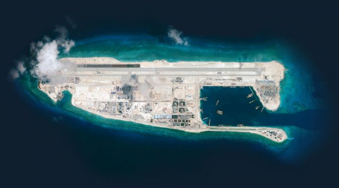
In the recent Philippine-China Arbitration Award, the tribunal determined that China’s artificial island construction on Mischief Reef was an unlawful violation of Philippine sovereign rights and jurisdiction over its continental shelf. Since Mischief Reef is a LTE and not a natural island, it constituted part of the Philippine continental shelf and seabed of the EEZ. China failed to seek and receive Philippine authorization for its artificial island construction, and therefore violated Articles 56(1)(b)(i), 60(1), and 80 of UNCLOS (Arbitration Award, para. 1016).

Foreign States, however, are not forbidden to construct installations and structures on a coastal State’s continental shelf per se. Only those installations and structures that are “for the [economic] purposes provided for in article 56” or that “interfere with the exercise of the rights of the coastal State” over its resources require coastal State consent. (See Article 60(1)(b) and (c)). 

But even if China converts its installations and structures into military platforms, their size and scope are so immense that they dramatically affect the quantity and quality of the living and non-living resources over which the Philippines has sovereign rights and jurisdiction. Although normally installations and structures that are built pursuant to military activities are not subject to coastal state consent, the industrial scale of Chinese activity lacks “due regard” for the rights and duties of the Philippines and its sovereign rights and jurisdiction over resources under Article 56 of UNCLOS.

If China had merely emplaced a small, unobtrusive military installation or structure on the seabed or landed an unmanned aerial vehicle at Mischief Reef as part of occasional military activities, it would not have been afoul of UNCLOS. Such incidental use of the seabed or an LTE (which is part of the seabed) are within the scope of permissible military activity in the same way as emplacement on the continental shelf of a small seabed military device. Foreign States may use the seabed for military installations and structures, and even artificial islands, as these purposes do not relate to exploring, exploiting, managing and conserving the natural resources. Only those military activities that rise to the level of or of sufficient are of such scale that they do not have “due regard” for the coastal state’s rights to living and non-living resources of the EEZ and continental shelf are impermissible.

The distinction is important because creation of the EEZ and recognition of coastal state sovereign rights and jurisdiction over the continental shelf was never envisioned to limit normal military activities. Current and future naval programs, in fact, may utilize a foreign coastal State’s seabed EEZ and continental shelf in a manner that is completely in accord with UNCLOS.

Where do we draw the line, however, between an insignificant presence and negligible interference that is lawful, and large-scale disruption that is unlawful? Like all legal doctrine, what constitutes genuine interference to coastal State sovereign rights and jurisdiction must be reasonable, i.e. not de minimis or trivial, but rather a substantial and apparent effect on the resources in the zone, as I discussed in Maritime Power and Law of the Sea. Emplacement of military devices or construction of military installations or structures in the EEZ and on the continental shelf of a coastal State must be judged by reasonableness, and not be of such scale or cross a threshold of effect that it interferes in a tangible or meaningful way with the coastal State’s resource rights.

China’s operation of military aircraft from a LTE is not a priori unlawful, any more than operation of military aircraft from a warship in the EEZ would be illegal. The reason that PLA Air Force military aircraft flights from the runway at Mischief Reef are objectionable and a violation of the Philippines’ coastal State rights is the magnitude of the activity and its effect on the living and non-living resources. Operation by a foreign warship of a small aerial vehicle that lands temporarily on an LTE, for example, would not be unlawful. Likewise, if a naval force emplaced a military payload inside a container and placed it on the seabed of the EEZ – that is, on the coastal State’s continental shelf – that would also be a lawful military activity.

James Kraska is Howard S. Levie Professor of International Law at the Stockton Center for the Study of International Law, U.S. Naval War College, Distinguished Fellow at the Law of the Sea Institute, University of California at Berkeley School of Law, and Senior Fellow, Center for Oceans Law and Policy, University of Virginia School of Law.

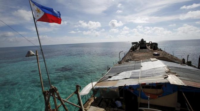
Featured Image: MARCH 10, 2016- Philippine Naval Ship, BRP Sierra Madre, sails near disputed Spratly Islands in the South China Sea (REUTERS/Erik De Castro)

The Changing Arctic

From author Ian Birdwell comes The Changing Arctic, a new column that will focus on the unique security challenges presented by the increasingly permissive environment in the High North. The Changing Arctic will examine legal precedents, rival claimants, and possible resolutions for disputes among the Arctic nations, as well as the economic implications of accessing the region’s plentiful resources.

By Ian Birdwell

The Northwest Passage was once a mythic trade route that claimed dozens of Europe’s foremost explorers. Today, travelers can traverse the passage once sought by the likes of Cabot, Drake, and Franklin on the world’s first cruise line1 from New York to Anchorage; the trip lasts only about a month. This shift in accessibility to the Arctic is a direct result of the planet’s warming climate. While increased access to the Arctic offers advantages in terms of commerce and tourism, it has also ushered in a new era of maritime security issues for Arctic nations. Specifically, as the Arctic Ocean warms and northern ice sheets recede, the United States, Russia, Canada, Norway, and Denmark will confront new aspects of maritime security, potentially causing rifts in long-established relationships. As such, it will prove increasingly important to examine the history of these states’ interactions with an eye to the Arctic Ocean’s commercial future.

The Arctic has always been a place of contention for the nations surrounding it. As receding sea ice opens new sea routes, however, a comprehensive understanding of historical territorial disputes in the Arctic and the influence of the UN Convention on the Law of the Seas (UNCLOS) will be necessary. Canada was the first nation to claim vast swaths of territory in the Arctic Ocean in 1925. Not long after the Soviet Union followed suit, laying down their own claim in 1937.2 Though not yet passable by sea, control of Arctic territories was viewed as beneficial as it provided access to and providence over air routes. While moderately contested, Arctic territorial disputes would only become a marquee issue during the Cold War, when the region gained strategic significance as an area to base submarine-launched nuclear weapons.

A map of overlapping territorial claims in the Arctic. (Encyclopedia Britannica Inc)

Arctic nations’ ratification of UNCLOS and the end of the Cold War were catalysts for tension. Notably, the provisions of UNCLOS did not affect Arctic relations until climate change began in earnest because the majority of exclusive economic zones provided within it were practically inaccessible. However, as the ice has melted, the tenants of the Convention have failed to alleviate emerging territorial concerns. Four of the five Arctic Nations have only recently ratified the UN Convention on the Law of the Seas3; the United States has still yet to do so.

As the waters warm, the Convention has been used as a tool to entrench territorial claims4 through UN appeals and report submissions to the Commission on the Limits of the Continental Shelf UN Subcommittee (CLCS). In short, the interested parties are attempting to exploit the convention as a way to extend legitimate Arctic claims beyond the 200 nautical mile mark, as in Norway’s Submission to the Commission on the Limits of the Continental Shelf (CLCS). While Norway’s submission is noted by the UN is based on independent negotiations with other Arctic states to extend5 beyond the 200 nautical mile mark6, the most recent Canadian7, Russian, and Danish8 submissions to the CLCS have been partial submissions, allowing states to make arguments for territorial extensions in the Arctic beyond the CLCS time limit of ten years following ratification of UNCLOS, as outlined in article four9 of Annex II of the Commission of the Limits of the Continental Shelf section of UNCLOS. This, coupled with the geography of the Arctic Ocean, makes Arctic relations more difficult as it pushes territorial disputes into the realm of global bureaucracy under a convention poorly designed for use at the top of the world.

Every square kilometer of ice that disappears raises the stakes in the Arctic region due to its large untapped commercial potential and as the world’s next trade route. Ice previously made oil exploration infeasible. Now, a shrinking ice sheet makes it easier to maintain oil rigs while offering opportunities for expansion. Russia has been pushing the most for this kind of expansion10 due to their expansive arctic coastline. The Russian Federation stands to gain the most commercially. However, the opportunity to control vast amounts of petroleum resources has the United States, Canada, and Denmark excited for drilling opportunities as well. While the recent drop in oil prices11 has tempered this excitement somewhat, time will tell if market shifts and changes in government regulation spark an oil rush in the Arctic. This throws not just national oil giants like Gazprom into the Arctic, but potentially any private oil company capable of negotiating the use of ocean territory into the mix, further complicating territorial disputes and international agreements. Thus, it becomes vital for nations on the Arctic Ocean to solidify their territorial claims either in international courts, diplomatic agreements, or through deterring their rivals from contesting their claims with force.

Passage through the Arctic region12 is likely to become incredibly important as ice levels stabilize and charts improve, yet there are several rising complications for passage that are not environmental. While most routes pass through either Canadian or Russian territorial waters, the entrances to those routes can be militarily contested by Denmark, the United States, and Norway, regardless of which nation’s territorial claims include those waters. This in and of itself poses a problem, because some form of stability and control is needed to ensure shipping routes can be used. While it is unlikely for routes to be blockaded or military conflict to arise, the fact passage control could be contested by any of these nations forces them to develop Arctic-capable assets.13

As climate change alters the Arctic Ocean, the transformation of the world’s highest seas will push the nations surrounding it into an area of unresolved territorial disputes and increasingly higher financial stakes. To provide for more detailed analysis on these nations, the consecutive articles in this series will take an in-depth look at each nation’s goals, limitations, and security concerns as the ice sheets recede.

Ian Birdwell holds a Bachelor’s Degree in Government and International Politics from George Mason University.

1. Paris, Costas “Luxury Cruise to Conquer Northwest Passage” Wall Street Journal. May 10, 2016  <http://www.wsj.com/articles/luxury-cruise-to-conquer-northwest-passage-1462872605 >

2. McKItterick, T.E.M. “The Validity of Territorial and Other Claims in polar Regions” Journal of Comparative legislation and International Law, Vol. 21, No. 1 (1939)

3. United Nations “Declarations and Statements” Oceans and Law of the Sea. Accessed June 3, 2016 <http://www.un.org/Depts/los/convention_agreements/convention_declarations.htm#Denmark Upon ratification>

4. Associated Press in Toronto “Canada to Claim North Pole as its own” The Guardian. December 9, 2013 <http://www.theguardian.com/world/2013/dec/10/canada-north-pole-claim>

5. Russian Federation “Commission on the Limits of the Continental Shelf Outer limits of the continental shelf beyond 200 nautical miles from the baselines” United Nations Oceans and Law of the Sea Division for Ocean Affairs and the Law of the Sea. Updates June 30, 2009 <http://www.un.org/depts/los/clcs_new/submissions_files/submission_rus.htm>

6. Kingdom of Norway “Commission on the limits of the Continental Shelf Outer Limits of the contiental shelf beyond 200 nautical miles from the baselines” United Nations Oceans and Law of the Sea Division for Ocean Affairs and the Law of the Sea. Updated August 20, 2009 <http://www.un.org/depts/los/clcs_new/submissions_files/submission_nor.htm>

7. Canada “Commission on the Limits of the Continental Shelf Outer limits of the continental shelf beyond 200 nautical miles from the baselines” United Nations Oceans and Law of the Sea Division for Ocean Affairs and the Law of the Sea. Updated December 29, 2014 <http://www.un.org/depts/los/clcs_new/submissions_files/submission_can_70_2013.htm>

8. Kingdom of Denmark “ Commission on the limits of the continental shelf outer limits of the conteitnal shelf beyond 200 nautical miles from the baselines” United Nations Oceans and Law of the Sea Division for Ocean Affairs and the Law of the Sea. Updated May 21, 2014 <http://www.un.org/depts/los/clcs_new/submissions_files/submission_dnk_68_2013.htm>

9. United Nations “United Nations Convention on the Law of the Sea Annex II” <http://www.un.org/depts/los/clcs_new/documents/annex2.htm>

10. Gurzu, Anca “Economic pain pushes Russia to drill in high Arctic” Politico April 24, 2016 <http://www.politico.eu/article/economic-pain-pushes-russia-to-drill-in-high-arctic-oil-energy-natural-gas/>

11. Krauss, C. and Stanley Reed “Shell Exits Arctic as slump in oil prices forces industry to retrench” New York Times. September 28, 2015 <http://www.nytimes.com/2015/09/29/business/international/royal-dutch-shell-alaska-oil-exploration-halt.html>

12. Stephens, Hugh “Northwest Passage a Key to Canada’s relationship with Asia” The Globe and Mail.May 19, 2016 <http://www.theglobeandmail.com/opinion/northwest-passage-a-key-to-canadas-relationship-with-asia/article30091202/>

13. Weber, Bob “Denmark joins Arctic arms race” The Toronto Star. July 26, 2009

Featured Image: Arctic waters (Incredible Arctic / Shutterstock)

Clash of Core Interests: Can One Mountain Hold Two Tigers? 核心利益的冲突:一山,不容,二虎?

South China Sea Topic Week

The following article is published in English and Chinese. 

By Tommy Jamison

The present dispute over the South China Sea doesn’t hinge on fishing rights, or oil fields, or even military bases. At its root the controversy stems from conflicting, profoundly held and historically consistent “core interests/核心利益.” On the one hand, the United States sees freedom of navigation as a fundamental pillar of the post-war order and integral to the past 70 years of relative peace and prosperity. On the other, China’s (re)assertion of sovereignty over the South China Sea should be contextualized within its century long campaign to recover territory lost under (semi)-imperialism. The historical grounding of both these arguments seems lost on much of Washington as well as Beijing. 

目前南海冲突的关键不是捕鱼权,不是油田,甚至也不是军事基地。从根本上讲,南海争议来源于不同的,有历史一致性的的核心利益。在一方面,美国认为航行自由是实现与二战以来持续七十年的安全与繁荣的重要基础。反过来,中国对南海的领土的主张跟其具有一百多年来“反殖民主义”的历史经历有很大的关系,我们应该思考这一背景。华盛顿跟北京一样,似乎都对双方的历史情况漠不关心。

Left, "China: It Cannot Be Reduced by Even a Little." Today a common image on social and state media. Right, "A Map of the Current Situation" c. 1900. "It is obvious at a glance" that a host of imperial powers threatened Chinese sovereignty.
Left, “China: It Cannot Be Reduced by Even a Little.” Today a common image on social and state media (People’s Daily). Right, “A Map of the Current Situation” c. 1900. “It is obvious at a glance” that a host of imperial powers threatened Chinese sovereignty. (Wikipedia)

Territorial controversies are not new in China. From the Opium War (1839-42) to the present, resisting imperialism and recovering lost territory have constituted core objectives of Chinese foreign policy. As such, it is only through first exploring this historical context that we understand the modern conflict in the South China Sea. Because of “Western” (semi)-imperialism, territorial disputes in Chinese modern history are very common and have profound political ramifications. The question of Shandong’s sovereignty was the fuse for the May Fourth movement (1919); Japan’s aggression in Manchuria (1931) led to the collapse of the post-WWI internationalist system and incited the Second World War; before 1997 Hong Kong was one of the world’s last formal colonies; today Sino-Taiwanese relations remain a powder keg, and so on. From this historical perspective of course the South China Sea is a sensitive question. It is also in some ways a legacy of resistance to imperialism and, to a certain extent, a continuation of the 20th century movement to recover lost territories.

中国的领土争议由来已久。从鸦片战争至今,反殖民主义与收复失地可以说是中国外交的核心目标之一。因此,我们首先要了解近代中国的历史背景,唯有如此,才能更好地了解现在的南海矛盾。由于西方帝国主义,在中国近代历史上类似的领土问题中无处不在,并产生深远的政治影响。山东省的主权问题是五四运动(1919)的导火线;日本在东北的侵略导致了一战后国际秩序的崩溃,也引发了第二次世界大战;1997之前,香港算世界上最后的正式殖民地之一;今天两岸关系还是一个“火药桶”等。从历史脉络的角度来看,南海主权理所当然是一个敏感的政治话题。同时,从某种角度上是反殖民主义的精神遗产,而且在一定程度上是二十世纪主权运动的继续。

At the same time, from a macroscopic perspective, the U.S. post-war diplomatic strategy can be summarized in four principles: 1) defend democratic regimes; 2) encourage free trade; 3) protect freedom of navigation, because it is a fundamental requirement of free trade (alongside today freedom of information, the skies and even space); and 4) spread liberalization, an admittedly abstract principle. In short, the U.S. post war strategy has been an attempt to replace the pre-war anarchic international system with a liberal internationalist system. China’s activity in the South China Sea threatens these aims, particularly freedom of navigation, and thus threatens the post-war international system. Freedom of navigation is often criticized in mainstream Chinese media, as in, “At root, freedom of navigation is an excuse to implement the ‘pacific rebalance’ strategy and to contain the emergence of China,” but the present world was developed from these ideals. As such, freedom of navigation is in no way an empty slogan, but rather a core U.S. interest.

与此同时,在宏观层面上,美国二战后的外交战略可以归纳为四个原则:一是保护民主政府;二是推动自由贸易;三是捍卫航行自由,因为航行自由是贸易自由最基本的要求,现在这个原则扩展到飞行自由、信息自由,甚至天空自由等范围。第四个原则是最抽象的——普及自由化。简而言之,美国二战后的战略试图用自由国际秩序来代替二战前的无政府国际秩序(anarchic international system)。如今,中国在南海的行为威胁到了这些原则,特别是航行自由,因此也威胁到了二战后的国际秩序。中国主流媒体常常讽刺航行自由,比如“归根结底是借推行航行自由之名,行推进亚太再平衡战略、遏制中国崛起”等,但是目前的世界格局正在这理念之上发展而来。因此,航行自由绝非一个凭空的口号,而是一个核心利益。

The Dagu Fort Memorial, Tianjin China (大沽口炮台纪念馆, 天津). It was built and modernized in the late nineteenth century in an effort to resist foreign amphibious attacks on Beijing. A sign helpfully notes that the memorial, “makes clear to subsequent generations: those who lag behind will be bullied, it is only through strength and prosperity that peace can be achieved.” 昭示后人:落后就要挨打,强盛才有安宁. (Author Photo)

None of this is to say that today’s South China Sea controversy is a direct continuation of China’s resistance to imperialism—far from it—but only to suggest that the conflict’s acuteness cannot be divorced from a larger historical context. When writing his history of Sino-U.S. relations from 1989-2001, David Lampton appropriated a saying about spousal conflict to sum up his findings: Same Bed, Different Dreams (同床异梦). That’s about right for the South China Sea as well. Still, the more worrying phrase might be the oft heard, “one mountain cannot hold two tigers” (一山,不容,二虎), which not coincidently frames the last chapter of Sarah Paine’s excellent history The Wars for Asia (1911-1949). Given the significance of historical context in this dispute, the potential for the misuse of history is likewise apparent. Eric Hobsbawm once wrote, “Historians are to nationalism what poppy-growers in Pakistan are to heroin-addicts: we supply the essential raw material for the market.” That danger seems particularly applicable to South China Sea where the trends of nationalism, hegemony, ecological scarcity and globalization intersect.

Still, one thing is for sure, giving serious thought to the historical background informing behavior on both sides of the Pacific would go a long way toward dispelling the distortions of modern day nationalists and bureaucrats alike. It might even help prevent an especially unnecessary war.  

Tommy Jamison is a PhD Candidate in International History at Harvard University. He served as an officer in the U.S. Navy between 2009-2014. 

Featured Image: South China Sea Goddess of Mercy 南山海上观音圣像.  (Percy)

Assessing the Military Significance of the South China Sea Land Features

South China Sea Topic Week

By Ching Chang

This article aims to provide a fair assessment of the military significance of the South China Sea land features. The term land feature is intentionally selected to avoid the trouble of arguing whether they are islands, reefs, shoals or rocks. How these land features can be categorized into the terms shown above may possibly cause differences according to the international regimes governing maritime jurisdictions, but not the military significance of the land features alone. Whether these land features may contain military value significant enough to be fought for are never decided by themselves. Other factors such as force, timing and additional characteristics associated with the space will fundamentally define their importance.

The space factor itself may only decide part of the operational conditions for any potential military campaign. Land features within the maritime theater should be assessed together with surrounding waters in the military geographical calculus. Hence, the land features, particularly within the maritime battlespace, are only a portion of geographical variables in the strategic and operational formulas for employing military forces. For the case of the South China Sea, the author would like to present the following points to remind strategic thinkers, political commentators, and military observers never to overstate, or even to overrate, the military significance of the land features in the South China Sea.

It is well proven by history that the land features in the South China Sea are fundamentally irrelevant with the generally perceived freedom of navigation, either in wartime or in relative peacetime. The United States Navy deployed submarine forces to target Japanese shipments in World War Two. Several engagements did occur in the South China Sea though no significant achievement was derived through these efforts.1 Nonetheless, it is pretty sure the land features had no influence on submarine blockade operations for either side.

Further, Operation Pocket Money launched by United States Navy Task Force 77 on May 9, 1972 during the Vietnam war for a naval mining mission was also irrelevant to those land features in the South China Sea, either.2 For these two obvious cases of paralyzing freedom of navigation around the South China Sea, those land features had no relevance within these operations. Only maritime assets, sometimes including air superiority, really mattered in operations aimed at hindering freedom of navigation.

Moreover, there are two maritime campaigns in the last half of the previous century specifically targeted on acquiring these land features. The first was the Battle of the Paracel Islands that occurred on January 19, 1974 between the naval forces of the People’s Republic of China and their maritime adversaries of the Republic of Vietnam Navy. It was originally a battle triggered by the effort of the South Vietnamese Navy to oust the Communist China’s naval vessels in the vicinity of the Paracel Islands. China successfully secured permanent control over the Crescent Group of the Paracel Islands after defeating Vietnamese maritime forces.

The second case was the 1988 Johnson South Reef Skirmish between the People’s Liberation Army Navy forces and the Socialist Republic of Vietnam Navy vessels. This naval battle took place over Johnson South Reef in the Spratly Islands on 14 March, 1988. China established its active presence around the Spratly Islands right after the decisive victory from a less than thirty-minute maritime engagement. By the end of 1988, China held six footholds on the land features in the Spratly Islands. The important lesson is that freedom of navigation in the South China Sea was never affected by these two naval campaigns specifically targeted on obtaining islands but fought with naval vessels to exclude adversary’s maritime presence around these land features.

From the two directions of logic reasoning shown above, the naval operations actually affected the freedom of navigation were irrelevant with the land features within the South China Sea. On the other hand, the naval campaigns for acquiring the land features within the South China Sea by expelling the adversary’s maritime presence around these land features were never relevant to the freedom of navigation, particularly, the maritime commercial transportation in the South China Sea. It only affected the maritime force within the surrounding waters of these land features. Why the territorial disputes fundamentally realized by the land features are so relevant to the freedom of navigation can be well perceived by measuring their locations subsequently introduced by the following second point.

The locations of these land features are away from major sea lines of communication as shown by the picture below.

SCS
South China Sea vessel traffic map. (marinevesseltraffic.com)

We may therefore understand why these land features may not affect freedom of navigation since most maritime commercial transportation is quite distant from these disputed land features. Even land features that may be potential hot spots and could influence maritime campaigns to some extent are hardly a factor in hindering maritime transportation activities on a significant scale. In terms of a maritime campaign in the South China Sea, maritime platforms and air superiority really matter, not these land features.

Some may argue that land-based weapons such as anti-ship missiles may substantially hinder freedom of navigation. Again, the prerequisites of this engagement scenario are maritime transportation activities close enough to these land features. Certain military assets can exercise the sea control function, but never the land features themselves. Without the maritime reconnaissance supporting functions to match with the weapon systems, those land based anti-ship missiles are nothing but a fist with long reach but poor aim.

No one within the military chain of command dare shoot at any long range target at sea so blindly without achieving  fully identification. Any case similar to the RMS Lusitania sunk by a German submarine on May 7, 1915 will present a nightmare to military and political decision makers.

W need to scrutinize the relative geographical locations of these land features. Basically, these land features are occupied by various parties and are all tangled together. For any individual land feature, regardless of its size and characteristics, it can only be defined as an isolated spot or foothold. Given the distances among these land features occupied by any single claimant in the South China Sea, it is impossible to form any meaningful defense. As no firepower from any other individual land feature may substantially cover the surrounding waters of other land features held by the friendly force units, the overall defensive posture is fragmented. No organized military operations seem feasible in the environment with the layout of land features as such. No  meaningful military front or defensive zone can be possibly established in this operational space.

All the land features cannot mutually support each other all since the effective range of land-based firepower may not match with the distances between these land features. Without maritime surveillance capability, long range anti-ship missiles may not be operationally relevant in many engagement scenarios. Given the historical experience of the island hopping operational concept successfully employed  in the Pacific theater in WWII, these land features can be easily bypassed because they cannot control any sea lane of communication. In other words, these land features can be ignored in any significant maritime campaign since they cannot form any organized military front or defense zone to support orchestrated military maneuvers.

It is reasonably expected that some may challenge this perspective with the recent developments and construction work occurring on these land features. It is undeniable that the capabilities of each land feature will be significantly enhanced after these improvements are completed. Accompanied with these enhanced capabilities, the logistical loads will also be increased. Although the strategic value of these land features would be seemingly increased, yet, the fundamental question remains the same: whether occupants of these land features may enact any meaningful military operations from these facilities including harbors, runways, berthing sites, and helicopter pads. Again, it will be decided by the distance between these land features and those frequently used maritime transportation routes. Enhancing military capabilities serving no substantial military tasks but only adding logistical burdens may make the land features a “strategic appendix” offering little utility but containing risk.

Last but not least, to answer the fundamental question of the military significance of the South China Sea land features, the question should be “what military operations in this maritime theater would rely on these land features?” Unquestionably, holding these land features may provide certain political leverage for claiming maritime jurisdiction upon adjacent waters. Nonetheless, fortification of these land features will not enhance existing positions on territorial claims, nor military significance for conducting potential operations. Facilities on these land features for supporting force employment and maritime surveillance will not be the most essential elements of any future military contingency within this maritime theater. Maritime assets will still be the core element. These land features can only serve a relatively minor role in a maritime campaign in the South China Sea as they always have in the past.

Chang Ching is a Research Fellow with the Society for Strategic Studies, Republic of China. The views expressed in this article are his own.

Endnotes

1. Heden, Karl E., Sunken Ships World War Two, Branden Books, 2006.

2. Mining of Haiphong Harbor, VietnamWar.net, http://www.vietnamwar.net/HaiphongHarbor.htm

Featured Image: China’s new airstrip built over Fiery Cross Reef in the South China Sea (CSIS image)