Dr. Angela Sutton joins the program to discuss her book, Pirates of the Slave Trade – The Battle of Cape Lopez and the Birth of an American Institution. Angela is a social and digital historian of the Atlantic World interested in the tools and methods that preserve and widen access to the sources that help refine and redefine popular understandings of American slavery and its modern consequences.
ByDale A. Jenkins, with contributions from Dr. Steve Wills
The Battle of Midway in June 1942 is best known for the brave actions of U.S. Navy carrier pilots who, despite heavy losses and uncoordinated action, were able to find and destroy four Japanese carriers, hundreds of Japanese naval aircraft, and hundreds of irreplaceable Japanese aviators and deck crews. What is not often remembered is that the defense of Midway was a joint effort with Marine Corps and Army aircraft also playing a brave role in the defense of the island against Japanese attack. Today, the U.S. military almost always fights in a joint context, and the Battle of Midway, especially in the key decision of the Japanese strike commander to rearm his reserve force for a second attack a Midway, highlight that even a small joint contribution can force an opponent to make fateful decisions. In this case, joint action contributed to a decision that cost the Imperial Japanese Navy victory and likely sealed the fate of its four-carrier task force and the lives of thousands of Japanese sailors.
A Joint but Disorganized American Team
By May 27, 1942, a week prior to the Battle of Midway, the code breakers at Pearl Harbor were able to advise Pacific Fleet commander Admiral Chester Nimitz that the Japanese Striking Force, which included at least four aircraft carriers, would launch an air attack at first light on June 4th against the defenses on Midway Island to prepare for an amphibious landing on the island. Nimitz reinforced Midway with every plane he could mobilize to defend the island: old Buffalo fighters and a few new Wildcats, Avenger torpedo planes, B-26 and B-17 bombers, Marine Dauntless dive bombers, Vindicators, and amphibious PBY Catalina patrol aircraft. Among these aircraft were a number of Marine Corps and Army aircraft. Nimitz planned to have three Pacific Fleet aircraft carriers, Enterprise, Hornet, and Yorktown in a flanking position northeast of the projected southeast Japanese track aimed directly at Midway, and then to coordinate with the land-based aircraft to concentrate his aircraft over the Striking Force for a simultaneous attack on the Japanese forces.
Poorly Coordinated Air Battle
While Army and Marine Corps aircraft did not make up the majority of the combat aircraft, they had the vital role of supporting Navy patrol aircraft by expanding the search around Midway Island and providing more early warning. Without the Army B-17 bombers performing maritime search, fewer Navy aircraft would have been less to patrol around the carrier task force. Although Navy patrol aircraft ultimately detected the Japanese occupation and striking forces, the additional patrol space provided by Army aircraft helped ensure the detection and warning to Midway before the attack.
At 0430 on June 4, the Japanese carriers launched 108 planes, half of their total force, to attack the Pacific Fleet shore defenses on Midway Island. The remaining planes constituted a reserve force: attack planes armed with anti-ship torpedoes and armor-piercing bombs, and a large complement of Zero fighters. At 0603, a U.S. PBY patrol aircraft from Midway located the Japanese carrier fleet. Strike aircraft from Midway flew to intercept the Japanese carriers and land-based Buffalo and Wildcat fighters rose to defend the island. Marine Corps gunners on Midway fired antiaircraft guns at the attacking Japanese aircraft. The military facilities on Midway were heavily damaged in the attack with hangers and barracks destroyed. Casualties among the Midway aircraft defending Midway were equally heavy. Of the 26 Marine Corps F2F Buffalo and F3F Wildcat aircraft that opposed the Japanese strike on Midway, fifteen were lost in combat. At the end of the battle only two air defense fighters were still operational to defend the island.
The joint attackers flying against the Japanese carriers fared little better than the joint air defense fighters. Six Avenger torpedo planes and four B-26s were the first to reach the Japanese carriers just after 0700 and were opposed by thirty Japanese Zeros. Five of the six Avenger torpedo planes were shot down trying to attack a Japanese carrier. Two B-26 aircraft targeted another carrier, and one was shot down, and two escaped after their ineffective torpedo drops. The fourth B-26 was on fire, and the pilot may have attempted a suicide crash into the bridge of Japanese flagship Akagi, but he narrowly missed and ended up in the ocean. During this encounter, the carriers were forced to maneuver, and although the attacks from the Midway planes failed to score any hits, they caused alarm and confusion in the Japanese command. Aircraft from the Pacific Fleet carriers, however, failed to appear because the carriers at 0600 were over sixty miles away from their expected position, were beyond their operating range and did not launch. As a result,Admiral Nimitz’s plan for a concentrated attack failed. Joint coordination of fires is an absolute necessity in operations and the resulting failure of the Midway-based joint air attack to inflict damage is a good example of what happens when coordination is not present.
Operational and Tactical Effects of Indecision
The operational effect on the Battle of Midway from their disjointed Marine Corps and Army aircraft, and later those of U.S. carrier torpedo squadrons, however, was significant. Japanese Striking Force commander Vice Admiral Chuichi Nagumo received a message earlier from the commander of the Midway attack force recommending another attack on Midway but was slow in deciding how to respond. Because of the desperate attacks from Midway, and his personal narrow escape on the Akagi bridge, Nagumo decided the reserve force needed to launch a second attack on Midway. At 0715 he ordered a change in the ordnance of the reserve planes from torpedoes and armor-piercing bombs to the high explosive impact bombs used on land targets. At 0728, a Japanese scout plane sent a message – ten enemy ships sighted; ship types not disclosed.
Now Nagumo was presented with a dilemma, he had two different targets – the facilities on Midway Island and the now-spotted ships. He decided to let his returning Midway strike force land first and then launch his reserve force armed with torpedoes to attack American ships. This required changing the ordnance loaded on his reserve aircraft back to torpedoes and armor-piercing bombs from the weapons loaded to attack Midway a second time. This difficult and time-consuming operation would cause a substantial delay in getting the aircraft airborne.
The disruption of the Japanese air planning cycle by Marine Corps and Army aircraft yielded key tactical results as well. The Japanese planes that had attacked Midway returned as planned, beginning at 0830. They all landed by 0917, but an attack of all four refueled and rearmed air groups against the Pacific Fleet carriers would not be ready to launch until about 1045, at the earliest. Authors Jonathan Tully and Anthony Parshall noted, “the ceaseless American air attacks had destroyed any reasonable possibility of “spotting the decks” (preparing for strike aircraft recovery before Tomonaga’s (the commander of the Japanese Midway bombing attack force) return because of the constant launch and recovery of combat air patrol (CAP) fighters,” needed to intercept the attacking Army and Marine aircraft from Midway. This Japanese loss of tempo in Japanese carrier operations due to these attacks would prove fatal of the Japanese force.
Rear Admiral Raymond Spruance, in command of carriers Enterprise and Hornet, had closed the range and dispatched full air groups from both carriers at about 0710. At 1025, Dauntless dive bombers from Enterprise, running extremely low on fuel,found and destroyed two Japanese carriers. At the same time Yorktown dive bombers destroyed a third carrier. Several hours later Enterprise dive bombers destroyed the fourth carrier, but not before its attack on Yorktown led to the loss of that ship. At the end of the day, Pacific Fleet carrier pilots had scored a major victory that marked a turning point in the Pacific War.
The attacks of the Midway-based aircraft had not scored any damage on the Japanese carriers or their escorts, but they contributed to the overall victory by keeping both the Japanese aircraft and ships engaged and unable to re-arm effectively for another Midway attack, or a strike on the American carriers. The delays in preparing this strike, and some luck left Japanese aircraft re-arming and refueling below decks when U.S. carrier-based dive bombers attacked, and they hits they scored on those planes caused conflagrations on the Japanese flattops that could not be extinguished.
Joint Lessons
The attacks by the Midway-based joint strike failed in their tactical mission but yielded later successful tactical and operational results. The Navy recognized the value of the B-17 in a scouting role to the point that Chief of Naval Operations Admiral Ernest King ordered a number of Army aircraft for naval service. The Army believed that the B-17’s from Midway had inflicted damage on the Japanese fleet, but the failed horizontal bombing attacks by the big Army bombers convinced the Japanese to ignore the Army planes in the future. Failures in hitting Japanese ships later in the Solomons campaign caused the Army to re-assess the B-17’s ability to attack ships. The Army later discovered that “skip bombing,” a process developed with the Australians was a more effective means through which Army aircraft could attack ships.
The joint aspect of Midway’s defense continued as Army Air Force aircraft provided defense of the island well into 1943 due to shortages of Navy and Marine Corps aircraft committed elsewhere in the Pacific War. The Marine Corps 6th Defense battalion remained in garrison on Midway until the end of the war, and the idea of Marine Air/Ground forces engaged in sea control warfare is returning to the Marine Corps in the form of Marine Littoral Regiments in Force Design 2030. The value in understanding the Battle of Midway from a joint perspective is that even the smallest amount of joint action at a crucial phase can fundamentally improve the odds of joint force success.
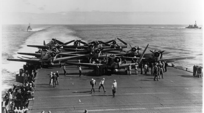
Featured Image: Torpedo Squadron Six (VT-6) TBD-1 aircraft are prepared for launching on USS Enterprise (CV-6) at about 0730-0740 hrs, June 4, 1942. (Official U.S. Navy Photograph, now in the collections of the National Archives)
Commodore Venugopal Vengalil joins the program to discuss China’s maritime interests in the Indian Ocean.
Commodore Vengalil graduated from National Defense Academy and was commissioned into Indian Navy in 1979. He is a specialist in Anti-Submarine Warfare and Mine Countermeasures. Among various assignments, he was the Naval Officer in Charge, Mumbai, prior to his retirement in 2007. Post retirement he worked as the head of shipping operations for a logistics company in Oman for five years and was fully involved in overseeing naval ships on anti-piracy patrol.
He is an alumnus of Defense Services Staff College Wellington, College of Naval Warfare, Mumbai, and Asia Pacific Centre for Security Studies, Honolulu, U.S. He writes in various forums on Maritime security issues. He is a distinguished member of Chennai Centre for China Studies.
How does one find an object not meant to be found? Forensic maritime investigators in 2017 stumbled across this question when searching for the disappeared ARA San Juan (S-42) – an Argentinian submarine whose mission centered around stealth. Despite the environmental challenges and the restrictions imposed by the profile of submarines, several complementary forensic tools have emerged as authoritative standards and best practices for underwater search operations. These include: (1) optimization of preliminary search boxes through Bayesian probabilities, with updates for posterior probabilities throughout the search; (2) side-scanning sonar systems; and (3) unmanned underwater vehicles (UUVs) for imagery, access, and identity verification. In explaining the efficacies and drawbacks of such methods, this analysis highlights the importance and evolving future of search optimization strategies.
How to Find a Lost Submarine
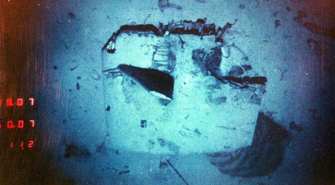
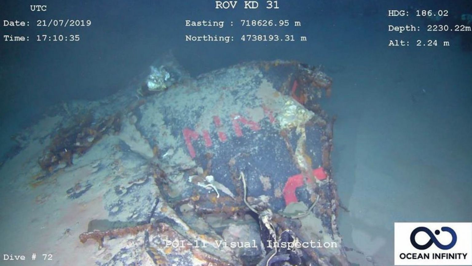
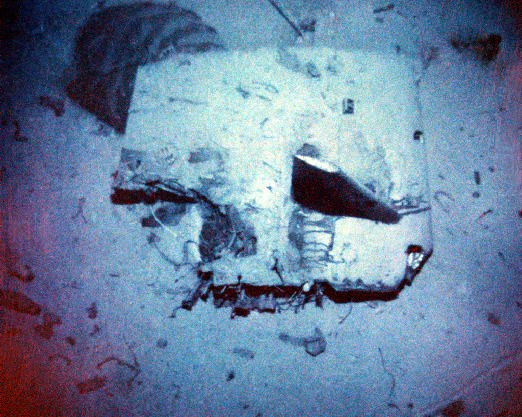
Forensic maritime investigators confront distinct challenges not relevant for traditional land-based investigations. Unlike terrestrial-based forensics, pre-established knowledge of a local maritime environment is sparse. Scientists have mapped 1/5th of the sea floor to modern standards with 100m resolution, but that means almost 290 million square kilometers of seafloor—twice the surface area of Mars—have not yet been surveyed.1 Furthermore, the remoteness of submarine operational areas casts a wide speculative net for a submarine’s last location, acting as a red herring for planners. For instance, the French Navy finally found the Minerve in July 2019 after searching since 1968, but the submarine’s position was only 28 miles off the coast of Toulouse.2
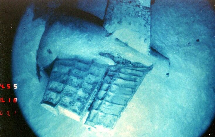
Debris from the French submarine Minerve. The letters MINE from the Minerve’s name are visible in the wreck. The Minerve was lost in January 1968. (French Navy photo)
The absence of existing charts, therefore, necessitates simultaneous 4-D mapping of the area—which is in short supply. Submarine debris is unidentifiable in satellite and aerial images due to surface opacity and the extreme depth of wreckages. Stratification conceals wreckage and clearing sedimentary buildup becomes extremely complicated due to sheer volume. An onsite “walk-over” survey, as described by Fenning and Donnelly3 in their description of geophysical methodologies, is simply impossible in a marine environment. Acidity and pH levels of the water also influence rates of decomposition, and must be considered for a simulation in the casualty scenario.
August 1986 – A view of the detached sail of the nuclear-powered attack submarine USS Scorpion (SSN-589) laying on the ocean floor. Depth 10,000 feet, 400 miles southwest of the Azores. The Scorpion was lost on May 22, 1968. (Photo via U.S. National Archives)
1: Bayesian Search Strategies
Constructing a preliminary search box requires meticulous strategizing and calculations. An error associated with misanalysis of primary sources can inevitably mislead search and rescue planners, delaying a submarine’s discovery. This occurred in the case of the USS Grayback, as Navy officials mistranslated the final coordinates of the submarine documented by a Japanese carrier-based bomber.4 An incorrectly interpreted digit in the longitudinal coordinates created an erroneous search area straying 160 kilometers from the Grayback’s actual location.5
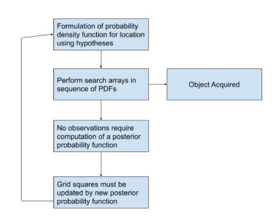
Pitfalls in relying on a single source cause planners to use search strategies based on Bayesian statistics. At a rudimentary level, Bayes’ theorem leverages probabilities of an event and prior knowledge regarding the condition of such event to produce a reasonable prediction of an event’s occurrence. Stakeholders will first formulate a range of possible stories surrounding a missing submarine’s location, pulling from all potential sources (eyewitness testimony of submarine’s last submergence, operational logs, mission record, etc.). The credibility and value of each piece of evidence will be judged by investigators and experts who will then collectively assign statistical weight to possible scenarios. For instance, the USS Scorpion’s forensic team invited experienced submarine commanders to present reasonable hypotheses that the scientists would later input into a probability density function.6 Such probability density functions assist planners in prioritizing certain search zones for surveying. Investigators resort to Bayesian statistics and Bayesian inference models because of its predictive power and the comprehensive results derived from relatively few inputs. Figure A demonstrates a four-step hierarchical convention in a Bayesian search strategy. The diagram summarizes the effects of updates on the model and introduces the posterior probability function (PPF).
Figure A.
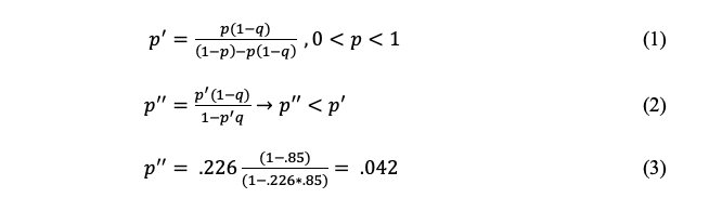
When a search area fails to yield any evidence pointing to a submarine, a posterior probability function will be calculated. A PPF’s utility and role is best explained by Equation (1-2)’s hypothetical representation of a grid square’s probability of containing a submarine. Variable q represents the probability of successful detection of a wreck and p quantifies the probability that the grid square does contain the wreck. Failing to find a wreck in a grid square will revise the probability of that grid square into p prime—a posterior probability.7 In this theoretical situation, the probabilities (for purely illustrative purposes) are: that a wreck in the grid square is 67% and the chances of a side-scan sonar identifying an anomaly is 85%.
Under those numeric assumptions, if the submarine were not found in the first survey, then a second survey of the same grid square, as denoted in Equation (3), will yield a secondary posterior probability of approximately 4.2%. Taken together, 4.2% represents the chances of success in finding the submarine in the given grid square in a second sweep.
Bayesian strategies are a staple of operations analysis search theory. For instance, the U.S Coast Guard incorporates Bayesian search strategies into its Search and Rescue Optimal Planning System (SAROPS).8 Successful outcomes produced by Bayesian search strategies have led to a general consensus on the technique’s utility. Identification of the underwater wreckage site of Air France Flight AF 477 underscored this utility. In the 2011 discovery, investigators created probability density functions (PDFs) from weighted scenarios supplemented by anterior knowledge of nine commercial aircraft accidents, known flight dynamics, and final trajectories.9 These PDFs drew search boxes that broadened until a Brazilian corvette recovered components of AF 477 buoyed on the surface.
Stern view of the nuclear-powered attack submarine USS Scorpion (SSN-589) showing the upper portion of the rudder (with draft markings) and the port stern plane. Note that the after portion of the engine room section (has been) telescoped into the machinery room. The ribs of the stern planes can be seen due to the deformation of the metal covering them. (Official U.S. Navy Photograph, from the collections of the Naval History and Heritage Command.)
However, Bayesian search strategies warrant legitimate criticism for their implicit use of subjective analysis. Terrill and Project Discover’s usage of Bayesian search strategies narrates a story of arbitrary values associated with each scenario. This is seen especially when the researchers place heavy subjective weight on interview data from the few remaining witnesses of a B-24 bomber’s last location.10 Taken together, Bayesian search strategies force analysts to quantify what is essentially qualitative information (e.g., the probability that an elderly man can accurately recall the events of the crash). These limitations create possibilities for higher uncertainty and a wider confidence interval. In addition, Bayesian search strategy can overshadow other powerful methods to form search boxes such as a Gittins index formula.11
2: Implementation of Side-Scanning Sonar for Seabed Imaging
Sonar, otherwise known as sound navigation and ranging, is a method that leverages sound propagation as a way to detect an object’s position and to visualize shapes from acoustic signatures in the form of echoes. The return frequency and radiated noise of an object allow for target acquisition and safe navigation by submarines dependent on the vicinity’s sound velocity profile; for researchers hoping to find inactive submarines, side-scan sonars lend mapping capabilities.
These devices construct images from cross-track slices supplied by continuous conical acoustic beams that reflect from the seafloor—wave emission speed can reach nearly 512 discrete sonar beams at a rate of 40 times a second.12 Data produced by side-scan sonars assembles a sonogram that converts into a digital form for visualization. The utility of side scan sonars is trinitarian; they create effective working images of swaths of sea floor when used in conjunction with bathymetric soundings and sub-bottom profiler data.13 Form factors of side-scan sonars allow the device to be highly mobile and serve as flexible, towable attachments for the tail of any-sized ships, giving liberty to human operators to adjust the directionality of ensonification. In addition, side-scan sonars contain adjustable frequency settings. A change in a side-scan sonar’s frequency will affect the sonar’s emitting wavelength, giving the operator flexibility on target acquisition. Side-scan sonars can operate as low as the 50kHz range to cover maximum seabed area; alternatively, the instrument can operate at 1 MHz for maximum resolution. This feature is extremely vital because submarines alter in length by model and different bodies of water share unique sound velocity profiles. Another advantage with side-scan sonars is their high precision record at sub-meter accuracy level for horizontal planes and at the centimeter-error level for vertical planes.14
Side-scan sonar systems exist as a vital apparatus to any search operation because the alternatives for mapping are minimal. Methods other than side-scan sonars like low-frequency multi-beam bathymetric data scanners, when reappropriated, are imperfect in object identification accuracy and better for scanning large seabed topographic structures like underwater mountains.15 Recent advances in magnetic anomaly detectors16 appear promising for future seabed exploration, but these instruments still require parallel approaches or in-tandem usage with side-scan sonars. Until magnetometers can extend their range beyond identifying magnetic objects in the Epipelagic Zone—the uppermost layer of the ocean where sunlight is still available for photosynthesis—side-scan sonars will be more consistent and versatile than magnetometers.
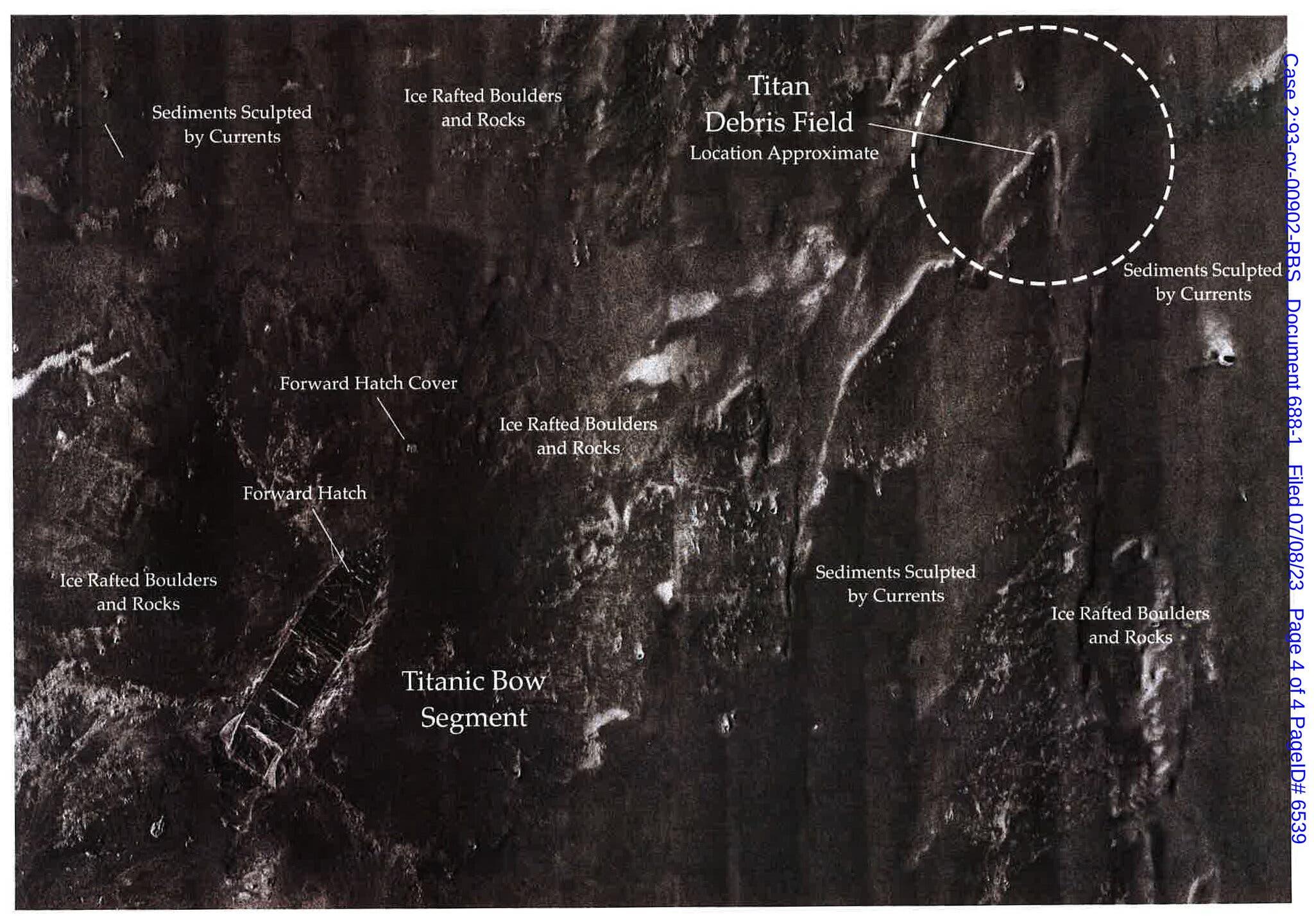
A mosaic of combined sonar images shows how close the Titan submersible was to the Titanic debris field. The Titan was lost on June 18, 2023. (Graphic via RMS Titanic Inc.)
Deployment of side-scan sonar occurs in the intermediary stage of search operations. A vessel will have a side-scan sonar mounted on or embedded in a towfish. Tethered to the main vessel, the side-scan sonar will perform a proper sonar survey of a proposed area by maintaining a rigid survey line along with a consistent towfish “altitude” when trailing the ship. Technicians carefully check the GPS receiver of the towfish to rectify course deviations, if needed, by manually changing the ship and towfish’s heading. A side-scan sonar operates with a survey mode to capture anomalies, which visual graphs will register and mark for later investigation by an unmanned underwater vehicle (UUV).
Unfortunately, handlers of side-scan sonars will notice several limitations that must be accommodated. A restriction to side-scan sonars is their inability to image directly below side-scan transducers. In other words, ships must compensate for a side-scanner’s blind spot by staggering their mow-the-lawn strategy. In addition, side-scan sonars contain software that prohibits the surpassing of a certain speed limit for towing, lest the receiver show significant scattering, absorption, and incoherent imagery. Like other instruments, side-scan sonars’ physical power consumption can be a variable for constraint.
Lastly, side-scan sonars perform according to the quality of the bathymetric data supplied. By themselves, side-scan sonars cannot efficiently identify changes in gradients and sound velocity profiles in real-time. High frequency/high resolution sonars operate at relatively short ranges via direct path sound propagation, which limits the refraction of sound waves and consequent distortion. This means the side-scan sonar will have a handicap in reporting the propagation paths of its rays and the sound channels, meaning knowledge of shadow zones may be omitted.17 This is a search investigator’s worst nightmare because failure to adequately search a grid may lead to incorrect, permanent marking of a square not holding a target. Imperfect data or simply lack of bathymetry data also contribute to the limitation of side-scan sonars.
3: Integration of Adaptive Unmanned Underwater Vehicles for Forensic Searches.
Since their introduction in the 1960s, UUVs have played a major role in every forensic investigation for a lost submarine. UUVs act as surrogates to human divers who cannot comfortably operate for extended periods of time at depths greater than 100 meters. To illustrate the need for UUVs, the USS Grayback was discovered at a depth of 1,417 feet (431 meters)18 — an impossible depth for divers, but not for the submarine itself. UUVs support forensic scientists in more than just underwater photography. UUVs collect bathymetry data, use ultrasonic imaging, measure strength of ocean currents, and detect foreign objects by their inertial or magnetic properties. Variants of UUVs are categorized into two robotic classes: remotely operated underwater vehicles (ROVs) and autonomous underwater vehicles (AUVs). ROVs allow for direct piloting by a human operator from a remote location with signal. AUVs function independently and follow pre-programmed behavioral search patterns.
A photo taken by a remotely operated vehicle (ROV) shows the sunken Indonesian Navy submarine KRI Nanggala-402 in Denpasar, Bali, Indonesia, May 18, 2021. KRI Nanggala-402 was lost on April 20, 2021. (Indonesian Navy photo)
The UUV variant, Remus 100,19 manufactured by Woods Hole Oceanographic Institute, deceptively resembles a torpedo, but functions as an effective explosive ordnance disposal detection device for the Navy. When refitted for search operations, the Remus (AUV) variant can perform dual-frequency side-scan sonar operations in independent mow-the-lawn search sequences.20 The Remus’ transponder wields GPS and doppler velocity logs that have proven to be more accurate in measurements than earlier AUVs. Customarily, forensic actors will deploy ROVs and AUVs for close-up identification or routine investigation of an anomaly, instead of wide-area search missions. These ROVs display high-definition, colorized video feeds for operators on a vessel; the latency between pilots and the ROV ranges from one to two seconds, making for fast time on responsive decisions.
Conclusion
This analysis examines a trinity of contemporary methods revolving around statistics and autonomous vehicles that aid officials in search and rescue operations for submarines. Corporations and officials should note that innovating and constructing more effective models in search operation becomes worthwhile when speed determines the ability to save lives. While this analysis discusses the employment of the aforementioned technology in the context of submarines, these methods can be theoretically implemented for other maritime interests: finding missing planes, undertaking the historical preservation of shipwreck sites, and embarking on deep-sea mining. For all these reasons, the U.S. has an inherent stake in advancing a discussion about progress in submarine search and rescue tactics.
Andrew Song is a U.S. Navy Nuclear Submarine Officer. His previous publications have appeared in The Wall Street Journal, The National Interest, Military Review, Journal of Indo-Pacific Affairs, and Proceedings. He graduated with a B.A. in Global Affairs from Yale University in 2022.
References
1 Amos, Jonathan. “One-Fifth of Earth’s Ocean Floor Is Now Mapped.” BBC News. BBC, June 20, 2020. https://www.bbc.com/news/science-environment-53119686.
2 “DOS Involved in the Finding of the French Submarine La Minerve.” Deep Ocean Search, October 3, 2019. http://www.deepoceansearch.com/2019/10/03/dos-involved-in-the-finding-of-the-french-submarine-la-minerve/.
3 Fenning, P. J., Donnelly, L. J., 2004. Geophysical techniques for forensic investigation. Geological Society of London Special Publications, 232, 11-20.
4 Elfrink, Tim. “A WWII Submarine Went Missing for 75 Years. High-Tech Undersea Drones Solved the Mystery.” The Washington Post. WP Company, November 11, 2019. https://www.washingtonpost.com/nation/2019/11/11/uss-grayback-discovered-tim-taylor-lost-project/.
5 Ibid.
6 L.D. Stone, “Operations Analysis during the Underwater Search for Scorpion” Naval Research Logistics Quarterly, vol. 18(2), pp. 141–157. 1971
7 Terrill, E., Moline, M., Scannon, P., Gallimore, E., Shramek, T., Nager, A., Anderson, M. (2017). Project Recover: Extending the Applications of Unmanned Platforms and Autonomy to Support Underwater MIA Searches. Oceanography,30(2), 150-159. Retrieved March 1, 2021, from http://www.jstor.org/stable/26201864
8 Stone, L. (2011). Operations Research Helps Locate the Underwater Wreckage of Air France Flight AF 447. Phalanx,44(4), 21-27. Retrieved March 2, 2021, http://www.jstor.org/stable/24910970
9 Soza & Company, Ltd. (1996). The Theory of Search: A Simplified Explanation: U.S. Coast Guard. Contract Number: DTCG23-95-D-HMS026. Retrieved on 2010-07-18 from http://cgauxsurfaceops.us/documents/TheTheoryofSearch.pdf
10 Terrill, E. “Project Recover.” Oceanography 2017.
11 Weitzman, Martin L. (1979). “Optimal Search for the Best Alternative”. Econometrica. 47 (3): 641–654.
12 “Side Scan Sonar.” Exploration Tools: Side Scan Sonar: NOAA Office of Ocean Exploration and Research, 2002. https://oceanexplorer.noaa.gov/technology/sonar/side-scan.html.
13 Jean M. Audibert, Jun Huang. Chapter 16 Geophysical and Geotechnical Design, Handbook of Offshore Engineering, Elsevier, 2005. ISBN 9780080443812, https://doi.org/10.1016/B978-0-08-044381-2.50023-0.
14 Aaron Micallef. Chapter 13: Marine Geomorphology: Geomorphological Mapping and the Study of Submarine Landslides, Development in Earth Surface Processes, Elsevier, Vol 15, 2011, pg 377-395 ISBN 9780444534460, https://doi.org/10.1016/B978-0-444-53446-0.00013-6 (https://www.sciencedirect.com/science/article/pii/B9780444534460000136)
15 Elfrink, “A WWII Submarine went Missing” The Washington Post. 2019.
16 Geophysical Surveying Using Magnetics Methods, January 16, 2004, University of Calgary https://web.archive.org/web/20050310171755/http://www.geo.ucalgary.ca/~wu/Goph547/CSM_MagNotes.pdf
17 “Side Scan Sonar.” United States Naval Academy , February 1, 2018. https://www.usna.edu/Users/oceano/pguth/md_help/geology_course/side_scan_sonar.htm. (2) Sonar Propagation. Department of Defense . Accessed April 7, 2021. https://fas.org/man/dod-101/navy/docs/es310/SNR_PROP/snr_prop.htm.
18 Elfrink, “A WWII Submarine went Missing” The Washington Post. 2019.
20 J. Ousingsawat and M. G. Earl, “Modified Lawn-Mower Search Pattern for Areas Comprised of Weighted Regions,” 2007 American Control Conference, New York, NY, USA, 2007, pp. 918-923, doi: 10.1109/ACC.2007.4282850.
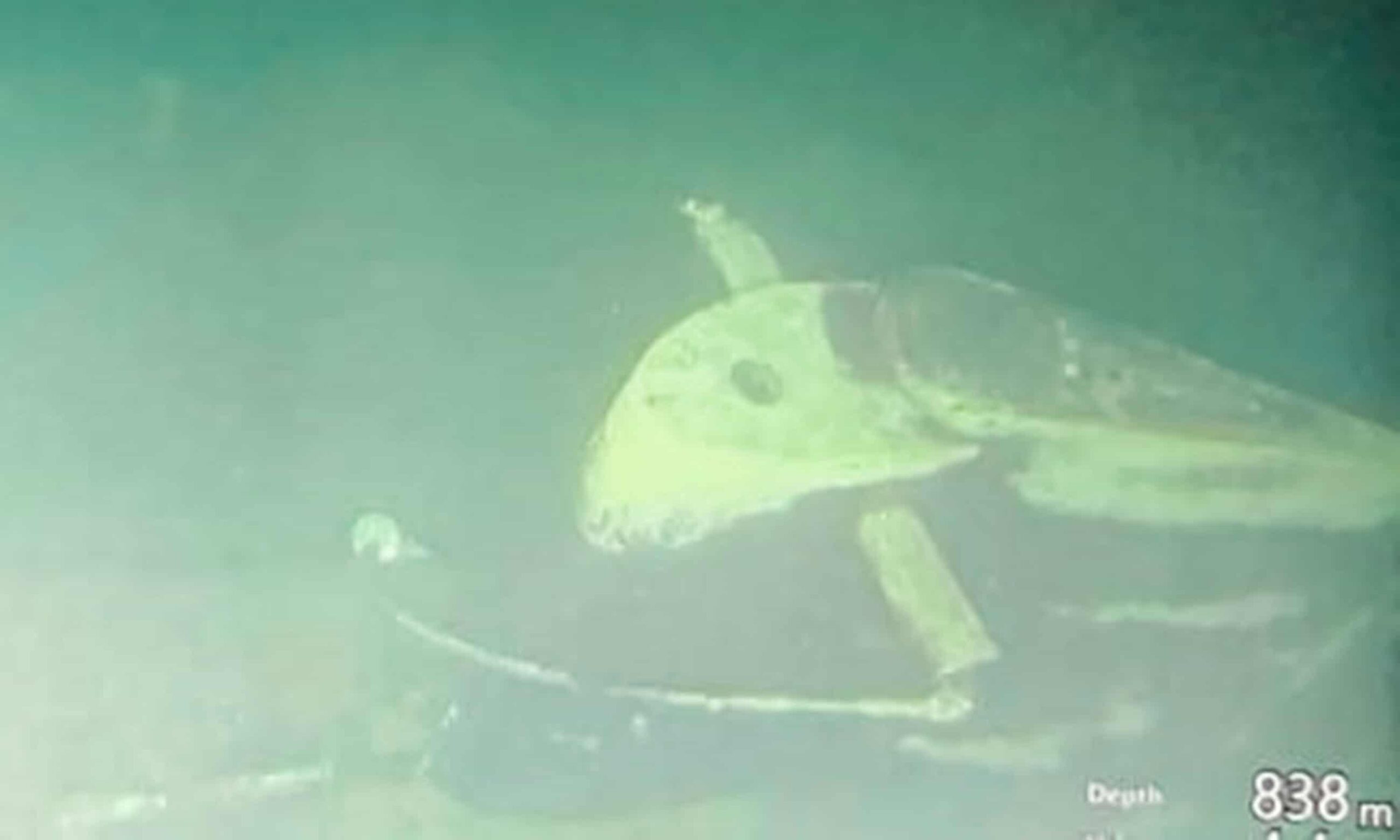
Featured Image: August 1986 – A view of the detached sail of the nuclear-powered attack submarine USS Scorpion (SSN-589) laying on the ocean floor. The starboard fairwater plane is visible protruding from the sail. Masts are visible extending from the top of the sail (located at the lower portion of the photograph). A large segment of the after section of the sail, including the deck access hatch, is missing. (Official U.S. Navy photograph)