
By Richard Mosier
One of the six force design imperatives in the CNO’s NAVPLAN 2022 is, “Expand Distance: Long-range precision fires across all domains and platforms with greater reach to enable naval forces to strike hostile targets while increasing our own survivability.”1 This design imperative has been partially achieved with the fielding of LRASM, Naval Strike Missile (NSM), Harpoon, SM-6, and forthcoming Maritime Strike Tomahawk, all designed to strike maritime targets at long ranges. However, the effective employment of these weapons against moving ships depends upon timely target location data for targeting, strike mission planning, and target location updates to strike aircraft and missiles enroute to the target. As the Navy expands the scope of its anti-ship arsenal, it needs to consider a concurrent expansion of the information architecture that is needed to employ these weapons at range.
Maritime Targeting Factors
Ships are moving targets, though only at the relatively slow speed of 30 knots. Even at that speed, the area of uncertainty of a target location expands rapidly as time accrues from the original launch of the weapon to the missile’s terminal acquisition of the target. A target location circle estimate of probability (CEP) of three square nautical miles at time of launch increases dramatically, as shown in Figure 1.
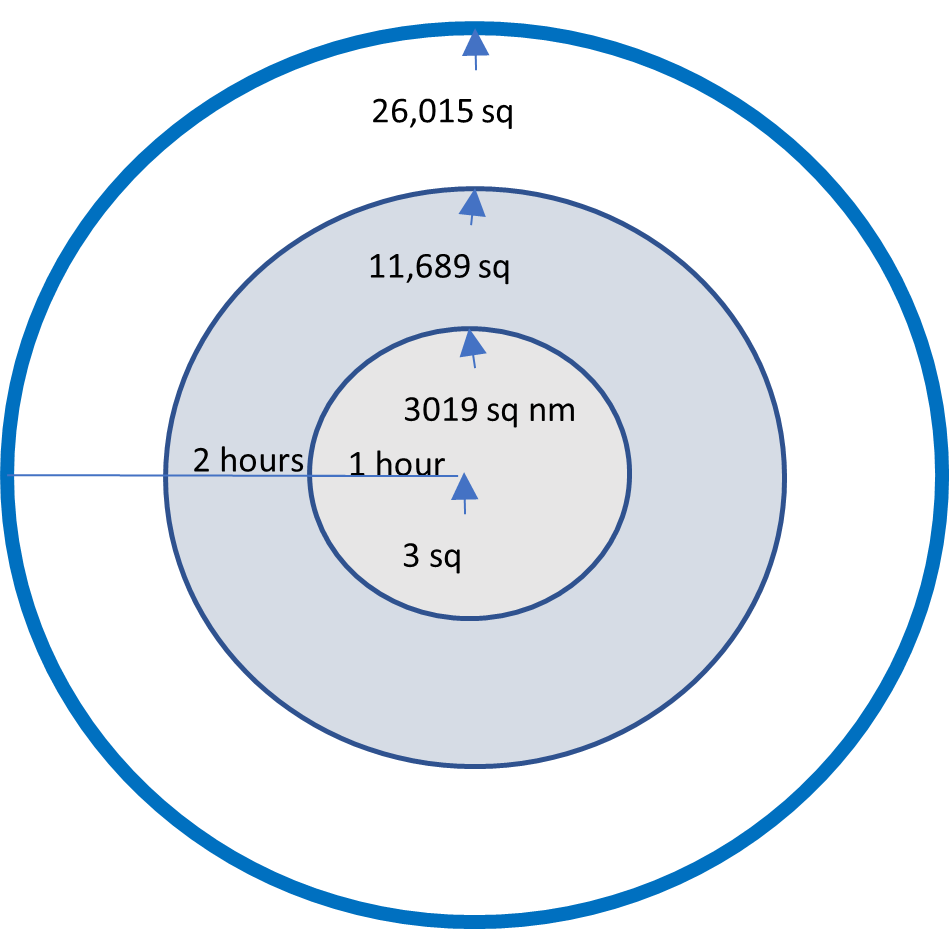
The size of the target location probability area is a function of the potential speed of the moving target and the time accrued from sensor data collect, to the tactical decision to launch the strike mission, and the availability of target location updates to the in-flight weapons and launch platforms. As with all engagements of moving targets, the attacking platform or weapon has to arrive in a target probability area that is small enough for their organic sensors to successfully acquire the target. Maintaining timely target location data is the critical factor in effectively cueing missiles and launch aircraft toward a point where they can then acquire the target with organic sensors. The acceptable target probability area varies based on the performance characteristics of the launch aircraft and missiles with respect to range, velocity, terminal target acquisition sensor performance, and capability for in-flight updates. The launch platforms and missile themselves often lack the organic sensor capability to secure much of this information themselves, especially when striking targets that could be hundreds of miles away. This creates a dependence on nonorganic sources for targeting and cueing information, which often take the form of highly specialized sensing platforms and capability architectures.
The time from last sensing to receipt of the target location update by the launch platform or the in-flight missile is the key determinant in the size of the target probability area, and the probability of striking the intended target. But this time can be considerable given the steps involved. The maritime strike process involves the following sequential steps: search, detect, locate, classify/identify, target (assign mission), track, plan mission, satisfy ROE, launch missile, provide target location updates, acquire intended target, strike target, and assess damage. The time it takes to satisfy the needs of this process increases the demand for timely information as the steps are being executed.
Rules of Engagement are promulgated to tactical echelons by the operational commander. One of the key constraints is to not strike non-belligerents. This constraint is a major driver of the anti-ship missile launch decision, and the launch decision-maker is responsible for assuring the missile strikes the target and not a non-belligerent. In-flight target updates provided by the decision-maker have to address not only the target ship, but also nearby non-belligerent shipping, which can substantially congest the area of uncertainty around a target. Multi-modal seeker capabilities, such as electro-optical, infrared, and passive receiver capabilities can also be used by the missile itself to help discriminate and validate targets.
Maritime Strike Targeting Alternatives
The capabilities required to track and satisfy ROE are unique for striking moving warships. Airborne assets are often considered to bring considerable information capability for facilitating maritime strike. Yet airborne assets have vulnerabilities in a contest with a peer such as China or Russia. Both countries have operational counter-air and fleet air defense capabilities that constitute a formidable threat to non-stealthy airborne surveillance and reconnaissance platforms. While these capabilities can make a substantial contribution prior to the first missile exchanges, they will be high-priority targets whose endurance in conflict is questionable. This suggests these legacy platforms will have to operate from protected airspace, and the calculation of risk will have to be balanced between survivability versus collecting information through greater proximity to the adversary. It also suggests the need to consider a transition from these legacy systems to stealthy airborne platforms or to relying more on space-based assets.
Satellites have their vulnerabilities as well. China and Russia surely have electronic and kinetic capabilities to attack satellites in orbit and threaten their complex worldwide ground infrastructure. The threat to satellites in orbit appears to be partially offset by the rapid proliferation of commercial satellites and the DoD strategy of orbiting hundreds of small, interlinked satellites that will be more resilient to wartime disruption. Yet the satellite, land, and undersea cable communications infrastructure that support satellite operations are also vulnerable to disruption from physical, cyber, and electronic attack.2
The architecture for providing airborne or satellite support to maritime strike in a great power conflict has to be designed for wartime resilience and assured minimum essential support for the effective employment of anti-ship weapons. This suggests some level of sensor system autonomy so they can provide support when their infrastructures are disrupted. It also suggests a link from the air and space sensor systems directly to the operational and tactical echelons that perform the maritime strike targeting functions.
To achieve the required track continuity, one option is a multi-mode sensor system that combines on the same platform the near-continuous wide-area search capability with another capability or mode for classifying detected contacts. Airborne systems such as JSTARS, U2, GLOBAL HAWK, P-8, and TRITON are examples. They provide integrated multi-sensor capabilities on a single platform, thereby avoiding the complexities and time delays inherent in coordinating various elements of collection by separate platforms. In most cases, they also provide datalinks for the dissemination of data directly to operational and tactical echelons. Yet these airborne systems may have challenges with survivability and endurance in a heavily contested battlespace, which encourages the development of ISR architecture in other domains.
One option for providing the critical data is a constellation of a large number of reconnaissance satellites that can provide the wartime resilience, frequency of coverage, and multiple sensor types that combine wide-area search with target classification capability. Ideally they would be able to pass this information directly to in-flight missiles and warfighters with launch authorities. But so far as these capabilities cannot currently be integrated onto a single satellite, the next best solution is a tightly integrated cluster of different types of satellites in the same orbital plane. This integration into clusters is required to avoid the complexities, vulnerabilities, and large time delays associated with orchestrating multiple, separately managed space systems.
The technology for satellite clusters exists, including onboard data processing, satellite-to-satellite crosslinks, and direct downlink of information and data to deployed land and ship tactical systems. As an example, BAE is developing an integrated cluster of reconnaissance satellites that has been described as:
“Azalea is planned as a cluster of three multi-sensor satellites from BAE Systems and one satellite with Iceye synthetic aperture radar (SAR) technology. Together, the satellites will collect optical, radar, and radio frequency (RF) data. The satellites will also be equipped with edge processors to analyze data while in orbit. BAE Systems announced the cluster on Sept. 7, with intent to launch in 2024.”3
If fielded in sufficient numbers, integrated clusters of reconnaissance satellites such as these offer the prospect of reduced dependence on vulnerable supporting infrastructures, minimal dependence on a cumbersome requirements and collection management structure, and the near real-time direct reporting of target information to tactical forces that can satisfy maritime strike requirements.
The Space Force and Space Development Agency’s seven-layered National Defense Space Architecture has been renamed the Proliferated Warfighter Space Architecture (PWSA), a decision taken to more clearly reflect the mission, and to avoid confusion with other DoD satellite constellations in orbit or planned.4 From the tactical perspective, the architecture will have to provide target location updates from offboard air and space ISR systems via LINK 16, the Integrated Broadcast Service (IBS), or the direct downlink of sensor data to systems in direct support of the strike and in pursuit of moving targets.
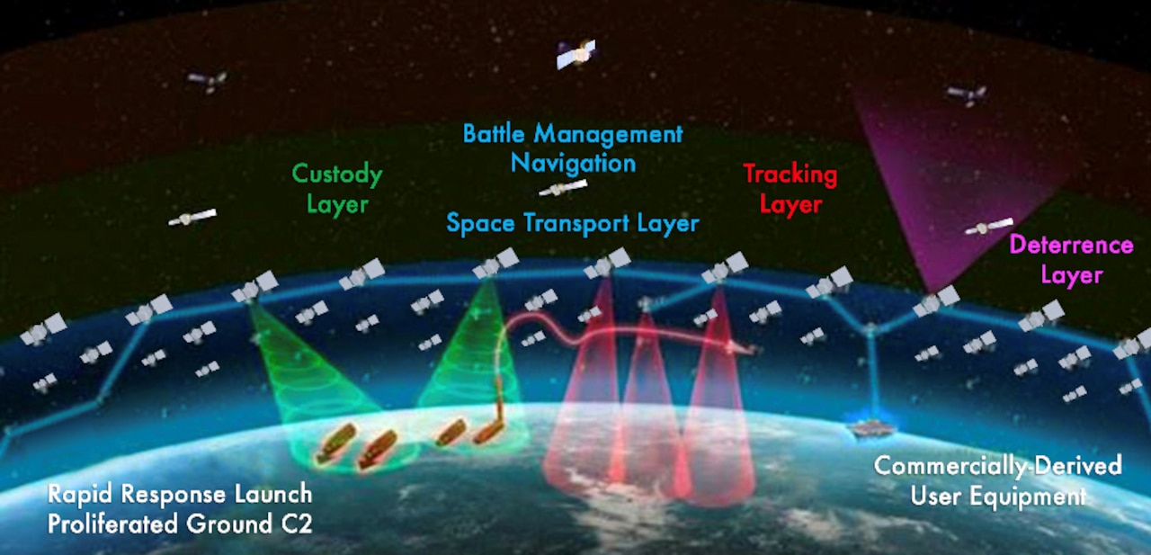
The PWSA, which addresses these interfaces, is more than a vision. The first 24 satellites in the transport layer are scheduled for launch in March 2023; an additional 128 in 2024; leading to a planned constellation of 300 to 500 satellites in low earth orbit. This architecture includes optical satellite-to-satellite cross links, satellite-to-aircraft cross links, satellite downlinks to air, land, and ship entities, and LINK 16 and Integrated Broadcast Service message interfaces with tactical terminals. Although not confirmed, logic would suggest this architecture also applies to satellite reconnaissance capabilities required for targeting ships, and could stand to substantially increase maritime strike capability.
The Way Ahead
From the technical perspective, satellite solutions are feasible and uniquely capable of offering the performance required for the employment of long-range anti-ship missiles against moving targets. The next step is for the Navy and Air Force to define the performance requirements and conduct the analysis of space and non-space alternatives. If the analysis supports a decision for a satellite reconnaissance solution for this mission need, JROC approval would force, or at least speed, the resolution of any remaining policy issues regarding the architecture, the acquisition, and in particular, the tasking and operation of satellite reconnaissance capabilities that are integral components of the force structure upon which maritime strike depends.
Progress is being made in the realization of the CNO’s imperative of expanding long-range strike capability. Long-range anti-ship weapons are being fielded in increasing numbers. The Navy has demonstrated and fully funded the fielding of Maritime Targeting Cells for installations ashore, afloat, and for expeditionary forces. DoD and commercial satellite technologies are advancing at a rapid pace, and the commercial sector is evolving large satellite constellations. The combined capabilities of airborne and space capabilities open the possibility of near-continuous ISR coverage and could provide forces with the targeting capability that is the lynchpin for successful attack against maritime targets.
Richard Mosier is a retired defense contractor systems engineer; Naval Flight Officer; OPNAV N2 civilian analyst; and OSD SES 4 responsible for oversight of tactical intelligence systems and leadership of major defense analyses on UAVs, signals intelligence, and C4ISR.
References
1. CNO NAVPLAN 2022 https://media.defense.gov/2022/Jul/26/2003042389/-1/-1/1/NAVIGATION%20PLAN%202022_SIGNED.PDF
2. The Threat to World’s Communications Backbone – the Vulnerability of Undersea cables https://www.navylookout.com/the-threat-to-worlds-communications-backbone-the-vulnerability-of-undersea-cables/
3. Rachel Jewett, BAE Systems Announces Multi-Sensor Azalea Satellite Cluster, Via Satellite, September 7, 2022 Link: https://www.youtube.com/watch?v=8tMDysRb-ny
4. Hitchens, T. (2023 01 23) Space Development Agency’s satellite plan gets new name, but focus on speed stays, Breaking Defense https://breakingdefense.com/2023/01/space-development-agencys-satellite-plan-gets-new-name-but-focus-on-speed-stays/
Featured Image: GULF OF ADEN (Oct. 8, 2012) An E-2C Hawkeye assigned to Carrier Air Wing (CVW) 1 sits on the flight deck of USS Enterprise (CVN 65) at night. (U.S. Navy photo by Mass Communication Specialist 2nd Class Brooks B. Patton Jr./Released)
Discover more from Center for International Maritime Security
Subscribe to get the latest posts sent to your email.
Another solution is including a recon missile in a salvo. Let’s imagine a salvo of anti-ship Tomahawks. All would proceed together at low level, but at certain programmed points the recon missile would pop up and use its sensors to update target location and confirm identity. This info it would send to the other missiles. The recon missile would then attack a target itself, the kinetics of impact and thermal effects of residual fuel being reasonably destructive in lieu of a warhead. This does not remove the requirement for antecedent wide area surveillance and identification, but does ease the problem of target tracking for long range shots.
This is a fascinating article that provided extensive information I was unaware of. I was particularly interested to see the similarities between the seven-layered PWSA and the Open Systems Interconnection (OSI) model for networking. As a USN veteran who worked on the TALOS Missile Guidance Radar 50 years ago, it is amazing to see the technological evolution of systems designed for wartime survival. It’s difficult to imagine where all of this will lead for humanity. And for the sake of humanity, I hope all this technology is ultimately only used as a deterrent. THANK YOU FOR YOUR SERVICE!