Category Archives: Territorial and Law of the Sea Disputes

United Nations Convention on the Law of the Sea, International Maritime Organization, and international maritime law.

US Department of State Seeks to Clarify Meaning of China’s 9-Dash Line Part 2

By Alex Calvo

This is the second installment in a five-part series summarizing and commenting the 5 December 2014 US Department of State “Limits in the Seas” issue explaining the different ways in which one may interpret Chinese maritime claims in the South China Sea. It is a long-standing US policy to try to get China to frame her maritime claims in terms of UNCLOS. Read part one.  

[otw_shortcode_button href=”https://cimsec.org/buying-cimsec-war-bonds/18115″ size=”medium” icon_position=”right” shape=”round” color_class=”otw-blue”]Donate to CIMSEC![/otw_shortcode_button]

Reviewing maritime zones and historic claims. The paper’s second section basically consists of a summary explanation of “Maritime Zones,” “Maritime Boundaries,” and “’Historic’ Bays and Title” according to UNCLOS. Three aspects are of particular significance. First of all, that the interpretation provided is not necessarily that considered correct by China. Although this is not always squarely addressed, when discussing whether Chinese claims in the South China Sea are or are not in accordance with international law we should first define international law, and there is the possibility that as China returns to a position of preeminence she may interpret some of its key provisions in a different way. Second, as the paper itself notes, while China ratified UNCLOS in 1996, the United States has not, although she “considers the substantive provisions of the LOS Convention cited in this study to reflect customary international law, as do international courts and tribunals.” Not all voices take such a straightforward view of Washington’s failure to ratify the convention while claiming that it is mostly a restatement of customary law and therefore applicable anyway.

The DOS paper includes a page devoted to “’Historic’ Bays and Title,” which text stresses that “The burden of establishing the existence of a historic bay or historic title is on the claimant,” adding that the US position is that in order to do this the country in question must “demonstrate (1) open, notorious, and effective exercise of authority over the body of water in question; (2) continuous exercise of that authority; and (3) acquiescence by foreign States in the exercise of that authority.” This passage reflects the US traditional position, as noted by J. Ashley Roach and Robert W. Smith (Editors) “In December 1986, the U.S. Department of State, Bureau of Public Affairs, published ‘Navigation Rights and the Gulf of Sidra,’ in GIST, a reference aid on U.S. foreign relations. The study discussed the history of U.S. responses, dating to the 18th century, to attempts by North African States to restrict navigation in these waters. The GIST stated, in part, that: Current law and customs: By custom, nations may lay historic claim to those bays and gulfs over which they have exhibited such a degree of open, notorious, continuous, and unchallenged control for an extended period of time as to preclude traditional high seas freedoms within such waters. Those waters (closed off by straight baselines) are treated as if they were part of the nation’s land mass, and the navigation of foreign vessels is generally subject to complete control by the nation.”

The text explains that this traditional American perspective is in line with the International Court of Justice and “the 1962 study on the ‘Juridical Regime of Historic Waters, Including Historic Bays,’ commissioned by the Conference that adopted the 1958 Geneva Conventions on the law of the sea.” It cites a number of cases, among them the 1951 Fisheries Case (U.K. v. Norway). It then turns its attention to the regulation of historic claims in Articles 10 and 15 of UNCLOS, saying that they are “strictly limited geographically and substantively” and apply “only with respect to bays and similar near-shore coastal configurations, not in areas of EEZ, continental shelf, or high seas.” Just like, when examining China’s posture we must take into account, as discussed later, the country’s history, and in particular the Opium Wars and their aftermath, American history has also shaped Washington’s perceptions and principles. The Barbary Wars were widely seen as laying down fundamental principles of national policy such as rejection of blackmail, freedom of navigation, and the right and duty to intervene far from American shores whenever the country’s interests, principles, and prestige were at stake. In the words of Jason Zeledon “The United States’s conflicts with the Barbary States (Algiers, Morocco, Tripoli, and Tunis) from 1784-1815 gripped the young nation, featured bold attempts by American policymakers to defend U.S. trade in the Mediterranean region and assert leadership in international affairs, set important precedents in American foreign relations (including the first U.S.-supported coup attempt that generated the line ‘to the shores of Tripoli’ in the Marine Corps Hymn), provided vital naval training for the War of 1812, and helped create an early sense of American exceptionalism.”

3 (1)
South China Sea map first published in January 2013 by China’s state mapping authority Sinomap Press, featureing 10 dashes instead of the previous nine.

Thus, while China’s position concerning the South China Sea may end up resting at least in part, on the concept of historic waters, even if this is not the case history and perceptions of history will surely still play an important role in determining Beijing’s policy. This, however, is not something only taking place within China, since no regional or extra-regional actor is immune to the phenomenon, adding to the already tense situation in South East Asia. In particular, a couple of centuries later, both the Barbary Wars and the Opium Wars remain powerful factors projecting their shadow on American and Chinese foreign and defense policy.

Trying to make Chinese claims fit with UNCLOS: three possible interpretations. The Department of State report then turns its attention to what constitutes the core of the paper, that is three possible interpretations of Chinese claims in the South China Sea and their compatibility or otherwise with International Law. Even without the need to fully agree with the paper’s views, it responds to a widely heard demand for clarification of China’s posture. In this regard, before we sum up the three perspectives, we should remember that while it is an interesting and useful exercise to try to fit Beijing’s (not always consistent) claims within the framework of UNCLOS and customary international law, China may have its own interpretations of the law, or seek to promote a different one. Since international law to a great extent reflects power realities on the ground, this should not come as a surprise, in particular given that in the view of China’s leaders many aspects of international law, and in particular the law of the sea, result from the same power dynamics that led to the country’s fragmentation and subservience from the mid XIX Century.

The paper also stresses that it is only in “maritime claims” (emphasis in the original) where “China’s position is unclear.” On the other hand, while some other countries do not accept them, Chinese claims on land are unequivocal, Beijing claiming “sovereignty over the islands within the dashed line”. The assertion in China’s 2009 Notes Verbales that “China has indisputable sovereignty over the islands in the South China Sea” is consistent with previous statements, and means that there is no doubt that Beijing considers all such islands to be national territory of the PRC.

Read the next installment here

Alex Calvo is a guest professor at Nagoya University (Japan) focusing on security and defence policy, international law, and military history in the Indian-Pacific Ocean. Region. A member of the Center for International Maritime Security (CIMSEC) and Taiwan’s South China Sea Think-Tank, he is currently writing a book about Asia’s role and contribution to the Allied victory in the Great War. He tweets @Alex__Calvo and his work can be found here.

[otw_shortcode_button href=”https://cimsec.org/buying-cimsec-war-bonds/18115″ size=”medium” icon_position=”right” shape=”round” color_class=”otw-blue”]Donate to CIMSEC![/otw_shortcode_button]

US Department of State Seeks to Clarify Meaning of China’s 9-Dash Line Part 1

By Alex Calvo

Introduction

Despite repeatedly stating that it will not take sides in territorial disputes in East Asia, Washington remains keenly interested in the ultimate fate of the South China Sea. In addition to perennial calls to settle disputes peacefully, regular reminders of the importance of freedom of navigation, military aid to regional actors like the Philippines, and support for a more active policy by non-littoral maritime democracies like India and Japan, the US Department of State (DOS) took a further step late last year by issuing a document, part of its “Limits in the Seas” series. The text seeks to explain the different ways in which one may interpret Chinese maritime claims in the South China Sea (“that the dashes are (1) lines within which China claims sovereignty over the islands, along with the maritime zones those islands would generate under the LOS Convention; (2) national boundary lines; or (3) the limits of so-called historic maritime claims of varying types”). It concludes that the “dashed-line claim does not accord with the international law of the sea” unless “China clarifies that” it “reflects only a claim to islands within that line and any maritime zones.” The text includes supporting Chinese official views, without attributing “to China the views of analysis of non-government sources, such as legal or other Chinese academics.” Concerning this latter restriction, although it is of course official sources which may be considered to be most authoritative when it comes to interpreting a government’s position, we should not forget that administrations in different countries will often resort to “two-track diplomacy” or employ semi or non-official back channels to test the waters and lay the groundwork for future formal negotiations.

[otw_shortcode_button href=”https://cimsec.org/buying-cimsec-war-bonds/18115″ size=”medium” icon_position=”right” shape=”round” color_class=”otw-blue”]Donate to CIMSEC![/otw_shortcode_button]
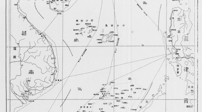
The object of this five-part series is to summarize the DOS document, while commenting on some of its most relevant features, and where appropriate going beyond the text and examining related aspects of the South China Sea conflict.

Tyranny of History: Can Washington claim not to take sides on Filipino territorial claims?

Before summarizing the “Limits in the Seas” document, we should note that the American policy of not taking sides concerning the ultimate issue of sovereignty could be challenged given Washington’s past sovereignty over the Philippine Archipelago. While this has not been publicly stressed by Manila to date, it could enter the debate as a means of putting more pressure on Washington to adopt a more robust posture.

Chinese Claims and Possible Interpretations According to International Law

In line with long-standing US demands that Beijing clarify the ultimate nature of her South China Sea claims, the DOS document analyzes those figures within UNCLOS and customary international law which may provide cover to Beijing’s claims. Issued on 5 December 2014, the Department of State paper begins by stressing that “China has not clarified through legislation, proclamation, or other official statements the legal basis or nature of its claim associated with the dashed-line map”, explains the “origins and evolution” of the dashed-line maps, provides a summary of the different maritime zones recognized and regulated by UNCLOS, and then proceeds to explain and discuss three possible interpretations of that claim “and the extent to which those interpretations are consistent with the international law of the sea.” The document contains a number of maps, including (Map 1) that referred to in China’s two May 2009 notes verbales to the UN Secretary General, which stated that “China has indisputable sovereignty over the islands in the South China Sea and the adjacent waters, and enjoys sovereign rights and jurisdiction over the relevant waters as well as the seabed and subsoil thereof. The above position is consistently held by the Chinese government, and is widely known by the international community.”

1
Nine-dash map attached to China’s two 2009 Notes Verbales.

A Look at Chinese Map Quality and Accuracy

The text first outlines the history of China’s maps of the South China Sea containing dashed lines, starting with a 1947 map published by the Nationalist government, noting that later PRC maps “appear to follow the old maps” (see L. Jinming and L. Dexia, “The Dotted Line on the Chinese Map of the South China Sea: A Note”, Ocean Dev’t & Int’l L., Volume 34, 2003, pp. 287-95, p. 289-290) with two significant changes: the removal of two dashes inside the Gulf of Tonkin (in an area partly delimited by Vietnam and the PRC in 2000) and the addition of a tenth dash to the East of Taiwan. These two changes can be interpreted in different ways, to some degree contradictory. On the one hand, the partial delimitation agreement with Vietnam could be seen as evidence of Chinese pragmatism and flexibility, and proof that it is possible for countries in the region to at least partly settle their disputes by diplomacy. On the other, explicitly encompassing Taiwan with an extra dash may be seen as a reinforcement of Chinese claims on the island not necessarily based on the will of her population. Alternatively, it could simply be a way to more comprehensively encompass the waters and features that Beijing (either directly or via Taipei) wishes to master.

The paper then examines successive Chinese maps from a cartographic perspective, stressing that “China has not published geographic coordinates specifying the location of the dashes. Therefore, all calculations in this study relating to the dashed line are approximate.” A similar criticism has sometimes been made of the San Francisco Treaty. The text also notes that “China does not assign numbers to the dashes,” and therefore those in the study are for “descriptive purposes only.” They “are not uniformly distributed,” being “separated from one another by between 106 (dashes 7 and 8) and 274 (dashes 3 and 4) nautical miles (nm).” This section of the paper stresses that “Nothing in this study is intended to take a definitive position regarding which features in the South China Sea are ‘islands’ under Article 121 of the LOS Convention or whether any such islands are ‘rocks’ under Article 121(3).” This is in line with Washington’s refusal to take sides concerning the ultimate sovereignty disputes in the region. The text notes that the “dashes are located in relatively close proximity to the mainland coasts and coastal islands of the littoral States surrounding the South China Sea,” and explains that, for example, Dash 4 is 24 nm from Borneo’s coast, part of Malaysia. Generally speaking, “the dashes are generally closer to the surrounding coasts of neighboring States than they are to the closest islands within the South China Sea,” and as explained later this is significant when it comes to interpreting the possible meaning of China’s dashed line, since one of the principles of the Law of the Sea is that land dominates the sea, and thus maritime boundaries tend as a general rule to be equidistant. That is, maritime boundaries tend to be roughly half way between two shores belonging to different states.

To hammer home this point, the study includes a set of six maps illustrating this. The report criticizes the technical quality of the PRC maps, saying that they are inconsistent, thus making it “complicated” to describe the dashed line, whose dashes are depicted in different maps “in varying sizes and locations.” Again, this is important in light of possible interpretations of Chinese claims, since this lack of consistency and quality not only obfuscates Chinese claims, introducing an additional measure of ambiguity, but also makes it more difficult to ascertain whether historical claims are being made and whether they are acceptable in light of international law.

The dashes change from map to map, with those “from the 2009 map” being “generally shorter and closer to the coasts of neighboring States” than those in the 1947 map. The dashed lines in these two maps are illustrated and compared in Map 5 of the document. The section concludes noting that the 2009 map, which Beijing distributed to the international community “is also cartographically inconsistent with other published Chinese maps.”

Read the next installment here

Alex Calvo is a guest professor at Nagoya University (Japan) focusing on security and defence policy, international law, and military history in the Indian-Pacific Ocean. Region. A member of the Center for International Maritime Security (CIMSEC) and Taiwan’s South China Sea Think-Tank, he is currently writing a book about Asia’s role and contribution to the Allied victory in the Great War. He tweets @Alex__Calvo and his work can be found here.

[otw_shortcode_button href=”https://cimsec.org/buying-cimsec-war-bonds/18115″ size=”medium” icon_position=”right” shape=”round” color_class=”otw-blue”]Donate to CIMSEC![/otw_shortcode_button]

South China Sea arbitration: Beijing puts forward her own views: The Finale

By Alex Calvo

This is the final installment in a four-part series devoted to China’s 7 December 2014 document, putting forward her views on the Philippines’ international arbitration case on the South China Sea. Although Beijing is refusing to take part in the proceedings, as confirmed following the Court’s 29 October 2015 ruling on jurisdiction, by issuing this document, and communicating in other ways with the Court, the PRC has failed to completely stay aloof from the case. It is thus interesting to analyze China’s narrative as laid down in that document. Read Part OnePart Two, Part Three

[otw_shortcode_button href=”https://cimsec.org/buying-cimsec-war-bonds/18115″ size=”medium” icon_position=”right” shape=”round” color_class=”otw-blue”]Donate to CIMSEC![/otw_shortcode_button]

The South China Sea and the Arctic: contradictions in China’s posture? Beijing’s insistence on excluding non-littoral estates from the dispute furthermore clashes with Chinese policy in the Arctic, where the country seeks a voice, arguing that despite just being a (self-labeled) “quasi-Arctic state” it has a right to at the very least make its voice heard given that the region has an impact on its interests. Countries like India, Japan, and the United States, may well put forward similar views concerning the South China Sea, considering themselves to be “quasi-littoral” states given among others their dependence on Sea Lanes of Communication (SLOCs) going through it.

Incentives to delay negotiations. A number of contradictory arguments may be put forward concerning this. Those wishing to blame China may accuse Beijing of seeking to change facts on the ground first (by, for example, occupation of some features and the artificial expansion of others), before engaging in meaningful negotiations. They may also argue Beijing is waiting for the balance of naval power in the region to shift further in her favor, or for developments elsewhere in the world to weaken the resolve of non-regional actors to intervene. On the other hand, those seeking to blame the Philippines may put forward similar accusations, arguing that Manila wishes to rearm (with US and Japanese assistance) first before engaging in serious negotiations with China. These voices may also put forward the view that Manila first wishes to take the moral high ground (among other means by the international arbitration bid), secure stronger support by the United States, or draw in other interested parties like Japan. We can thus see how both sides have potential reasons not to seek a speedy start of bilateral negotiations.

China defends cooperation prior to delimitation, but it is Taiwan and Japan which have implemented the principle. Section IV is perhaps not so original, basically reiterating arguments already expounded in Section III. It still contains some paragraphs worthy of comment, though. In Paragraph 61 the text refers to the “Agreement for Joint Marine Seismic Undertaking in Certain Areas in the South China Sea” between China National Offshore Oil Corporation and Philippine National Oil Company, expanded in 2005 to “a tripartite agreement, with the participation of Vietnam Oil and Gas Corporation.” The text praises it as “a good example of the constructive efforts made by the States concerned to enhance cooperation and create conditions for a negotiated settlement of the disputes in the South China Sea,” stressing that the “maritime area covered by that agreement is within that covered in the present arbitration initiated by the Philippines.” Few would disagree that agreements like this do indeed offer an interesting path, allowing states party to a dispute to build trust while concentrating on the joint development and management of natural resources, leaving for later tricky questions of sovereignty. When we move from the realm of theory to that of practice, however, we find that such efforts involving China have not been successful. In the South China Sea, possible cooperation seems to have given way to violent competition, with oil rigs becoming “weapons” rather than symbols of cooperation. In the East China Sea, where a similar agreement was concluded with Japan, it later unraveled and has not been implemented. It is Taiwan, not China, that has actively pushed for joint management that could proceed while leaving sovereignty for later. This has resulted not only in President Ma’s East China Sea Peace Initiative, but in a fisheries agreement with Japan along these lines. Whatever the reasons, no similar agreement has been concluded and effectively implemented by the PRC.

 8,- “Chinese Embassy to the Netherlands. While refusing to take part in the arbitration proceedings, China has regularly communicated with the Court, often through this Embassy.

Chinese Embassy to the Netherlands. While refusing to take part in the arbitration proceedings, China has regularly communicated with the Court, often through this Embassy.

Partial versus comprehensive solutions in territorial conflicts. It is interesting to note the position paper’s critique of Manila’s arbitration bid in Paragraph 68, which argues that “The issues presented by the Philippines for arbitration constitute an integral part of maritime delimitation between China and the Philippines” and that “The Philippines’ approach of splitting its maritime delimitation dispute with China and selecting some of the issues for arbitration, if permitted, will inevitably destroy the integrity and indivisibility of maritime delimitation and contravene the principle that maritime delimitation must be based on international law as referred to in Article 38 of the ICJ Statute and that ‘all relevant factors must be taken into account.’ This will adversely affect the future equitable solution of the dispute of maritime delimitation between China and the Philippines.” While the first sentence is just a reiteration, the second one touches upon a legitimate concern, given that any partial ruling runs the risk not only of being difficult to implement due to its non-comprehensive nature, but also of not being equitable for lack of consideration of certain factors concerning areas or aspects not included in the arbitration proceedings. This could be a reason to reject this approach. On the other hand, it could be said that history shows how countries often reach limited agreements, either because they are unable to successfully reach a comprehensive settlement, or because they prefer to start dealing with those issues where they either expect it to be easier to reach an understanding or which are more pressing. China is no stranger to this posture. The reference to equity though is important since an equitable settlement is often one involving tradeoffs, and such tradeoffs will often only be acceptable when covering a case’s full spectrum of issues.

The long shadow of history in China’s narrative against compulsory arbitration. In Section V the text demands full respect for China’s “right to freely choose the means of dispute settlement”, while defending the position that the “rejection of and non-participation in the present arbitration is solidly grounded in international law.” The stress on “consent” (76), while not amounting to any Chinese singularity, may also reflect the country’s experience with the so-called “unequal treaties.” Also important is the reference (76) to the “package deal” nature of UNCLOS, which is indeed the case, and as the text notes involved “extended and arduous negotiations” with regard to Part XV dealing with dispute settlement. The position paper insists (78) that the resulting “balance” in that Part was “a critical factor” prompting many countries to sign the convention, and again cites the Southern Bluefin Tuna Case, this time to reinforce the notion that compulsory arbitration should be restricted to cases where all parties agreed to it. The problem with this is that if all parties agree to arbitration, then there is no need for the procedure to be compulsory, and if compulsory proceedings are provided for, it is with a view to at least some cases where one or more countries may indeed oppose them. If “compulsory” arbitration could only move forward with the post-ratification consent of all parties involved, one could argue that there would be no need for UNCLOS to lay down areas where arbitration could be mandatory.

Abuse of right. Another legal principle that the text delves into (84) is that of “abuse of right”, in tandem with the above-mentioned “good faith.” These are general principles of law found, in some form or another, in most legal systems. The text cites Article 300 of UNCLOS, which lays down that “States Parties shall fulfill in good faith the obligations assumed under this Convention and shall exercise the rights, jurisdiction and freedoms recognized in this Convention in a manner which would not constitute an abuse of right,” adding that Manila has not done so by seeking to bypass Beijing’s refusal to engage in arbitration and existing agreements to settle the dispute by negotiations.

Conclusions. Beijing’s document, despite stressing that it is not a formal reply, systematically rejects all of Manila’s arguments, while summarizing China’s position. While China emphasizes the Philippines’ alleged promise to deal with the issue bilaterally, the text refers to treaties between other countries, mentions ASEAN, and touches upon the sensitive issue of Taiwan, in a reminder of how difficult it is to keep things bilateral in this corner of the world. Reading in between lines we can also see how history casts a long shadow over Beijing’s position, a position which is not always free from contradictions, for example when it defends the delay in opening up negotiations with Manila by stressing the complexities involved due to among others the large number of parties, while at the same time emphasizing her traditional stance that the dispute should be approached bilaterally. At the end of the day, it will be might (in a broad sense of the word, not necessarily limited to naval power, and in particular traditional lethal naval power), rather than right which will determine the fate of the South China Sea, but this does not mean that international law will not play a role, and hence the need to carefully follow developments in the international arbitration case initiated by the Philippines, together with rearmament and greater coordination among maritime democracies.

Alex Calvo is a guest professor at Nagoya University (Japan) focusing on security and defence policy, international law, and military history in the Indian-Pacific Ocean Region. A member of the Center for International Maritime Security (CIMSEC) and Taiwan’s South China Sea Think-Tank, he is currently writing a book about Asia’s role and contribution to the Allied victory in the Great War. He tweets @Alex__Calvo and his work can be found here.

[otw_shortcode_button href=”https://cimsec.org/buying-cimsec-war-bonds/18115″ size=”medium” icon_position=”right” shape=”round” color_class=”otw-blue”]Donate to CIMSEC![/otw_shortcode_button]

Sea Control 106 – Arctic Circle

seacontrol2Ever wonder what is happening in the Arctic? Sea Control: North America host Matthew Merighi interviews three graduate students running the Fletcher School of Law and Diplomacy’s annual Arctic Conference: Molly Douglass, Rabia Altaf, and Drew Yerkes. The interview examines border claims, resource politics, and how the various regional actors are approaching this new frontier.   

DOWNLOAD: Arctic Circle