Tag Archives: united kingdom

Joint Warrior 2015 Infographic

jointwarrior

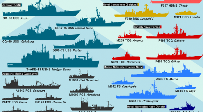
Joint Warrior is the twice-yearly UK-led NATO exercise in Scotland involving both sea, air and land assets.

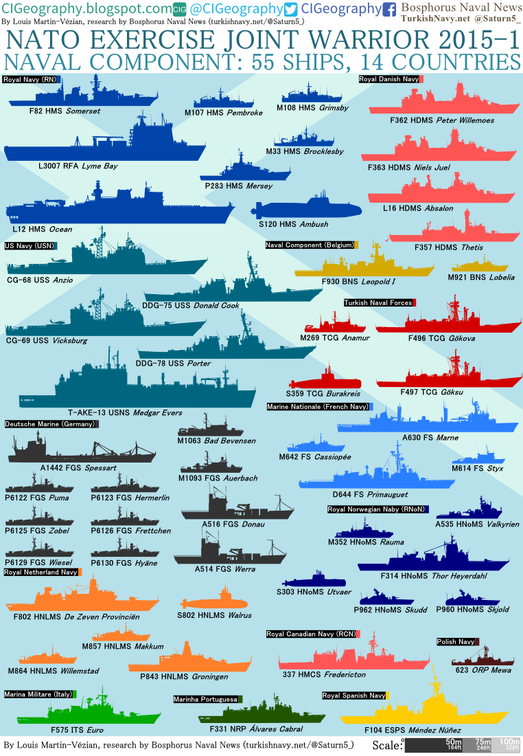
Joint Warrior 15-1 has gathered 55 ships, a similar number of planes, and 14,000 personnel from 14 countries. It will run from 11 to 24 April. The maritime part of the exercise will focus on mine warfare and fast attack craft swarming-attacks.2121

Two standing NATO mine counter-measures groups (SNMCMG1, SNMCMG2), including mine countermeasures vessels (MCMV) from 8 countries, arrived in Faslane (30km from Glasgow) earlier last week.

German and Norwegian fast attack craft (FAC) were deployed as well: 6 Gepard-class fast attack craft of the German navy (P6122 Puma, P6123 Hermerlin, P6125 Zobel, P6126 Frettchen, P6129 Wiesel, P6130 Hyäne) and the two Skjold-class stealth corvettes of the Royal Norwegian Navy. The German Gepard-class is an evolution of the Albatros-class, modernized with the addition of a GDC-RAM launcher. The Norwegian P960 Skjold and P962 Skudd are capable of reaching 60 knots and carrying 8 NSM anti-ship missiles.

This edition of Joint Warrior is the largest to date, and could be compared to RIMPAC, although RIMPAC2014 gathered 55 ships, 200 aircraft and 25.000 personnel. Thus, JW151 is 140 aircraft and 10,000 personnel smaller than RIMPAC2014.

This extraordinary participation in a NATO exercise may come in reaction to Russia’s increasingly aggressive posture towards Europe since March 2014. Over both Europe and Japan, Russian strategic bomber flights are becoming more and more frequent.

Louis Martin-Vézian is the co-president of the French chapter at CIMSEC.org, and the founder of CIGeography, where he posts his maps and infographics on various security and defense topics. He is currently studying Geography and Political Science in Lyon, France.


Strategic Insights Arctic Special Issue – Call for Papers

The December 2015 special issue of Strategic Insights magazine will deal with maritime security problems associated with the Arctic. Although international attention in recent months has shifted to places such as Russia/Ukraine, Syria/Iraq, Greece, or the South China Sea, the High North retains its unique position and potential as a future site of conflict and cooperation, disruptive technology, and a major maritime trade shortcut. We are looking for thought-provoking contributions that address challenges and risks in the High North, and provide fresh perspectives for our readers. Whether it is a particularly Canadian, American, Russian, Norwegian, Danish, or any other nation-state view, a discussion of current and future operations, or perspectives on maritime security from your particular point of view, all suggestions are welcome.

It doesn't happen often that an entire ice-breaking fleet is in one picture... but when it does, it's set to be cool.
It doesn’t happen often that an entire ice-breaking fleet is in one picture… but when it does, it’s set to be cool.

Anyone with an interest in writing an article should send a short note Sebastian Bruns, member of the SI editorial board and fellow CIMSECian, at sb@riskintelligence.eu. Please include a short bullet-point list of what you would like to discuss and provide 2-3 sentences on your professional background. If your article is accepted for publication, remuneration is 300.00 € (or – currently – 335.00 USD) per article and will be paid via bank transfer on the first of the month after publication of the respective issue. The deadline for your final article is 15 November 2015.

From Russia with love.

Strategic Insights draws on the focus and geographical coverage of Risk Intelligence’s MaRisk maritime security monitor, but takes a wider look at the nature of maritime risk in different threat locations around the world. Each issue goes beyond facts and figures to consider the drivers of maritime security challenges and how these challenges will evolve in the future.
The focus of Strategic Insights is on security threats and political-military developments with a maritime dimension, particularly non-traditional security issues such as piracy, maritime terrorism, insurgency, smuggling, and port security. The journal is read by players in the maritime industry, law enforcement agencies, think tanks and institutions, and inter-governmental regional security bodies. A particular emphasis is placed on articles that offer policy-relevant and operational analysis relevant to the maritime community. The style is a mix of journalism and academic, length about 2,500-3,000 words. Visit the website for more info and to download your complimentary free issue.

Sebastian Bruns is a Research Fellow at the Institute for Security Policy at Kiel University where he is responsible for all things maritime. He is also one of the editors for Strategic Insights magazine.

March 24, A Very Significant Day For Mariners

John-HarrisonIf you were aware of the grounding of the British fleet, and the deaths of over 2000 sailors, off the Isles of Scilly, west of Cornwall, in October 1707, then you are either the rare supercentenarian or you are a maritime history geek such as myself. All of this begs the question, why is this date in maritime history so important?

Well since you’re wondering, it took those deaths to get the attention of the Admiralty in solving one of the biggest conundrums in ocean navigation, accurately measuring longitude.  Seven years later in 1714 Parliament passed the Longitude Act,  [they] convened a Board of Longitude to examine the problem and set up a £20,000 ( $2.5 Million 2015) prize for the person who could invent a means of finding longitude to an accuracy of 30 miles after a six week voyage to the West Indies. It also made minor awards for discoveries and improvements to the general problem. (Citation from The Royal Naval Museum) 

John Harrison undertook this challenge with no formal education or training. By Jove he was just a self taught clock maker! John’s belief was that time would prove the correct measurement of Longitude. He was going head to head with the Astronomer Royal, Nevil Maskelyne, the most prominent proponent of an astronomy-based method.  Maskelyne wholeheartedly believed that longitude could be calculated using lunar charts and tables, and that using a mechanical piece was irrelevant.  

The prize offered by the Board of Longitude was a tempting one for Harrison and he set out to make a sea-going timekeeper that could keep accurate time to claim the prize. It became his life-long work. The idea was to be able to compare local time to that of the pre-determined Greenwich time (which the timekeeper or chronometer would be set to), and thus find the longitudinal position of the ship.

After years of development and five versions of his time piece, H-1 to H-5, it was a copy of H-4 that accompanied Captain Cook’s h1_smsecond voyage (1772-1774). The Captain was so impressed with the chronometer that he was able to accurately chart the South Sea Islands. He eventually took the chronometer on his third and final voyage. 

John, however did not win the entire prize. During the periods of 1765 and 1773 he was awarded a little more than half. In 1774 the Parliament set new standards for winning the prize; all entries must be submitted in duplicate, undergo testing for one year at Greenwich, be further tested on approved voyages by the board. h4

John Harrison died on his 83rd birthday on March 24, 1776 at Red Lion Square, London. He was buried in a vault in Hampstead church. A tomb was later erected by his son, William. In 1879, the London Company of Clockmakers reconstructed it as a mark of respect for his achievements- even though Harrison had not been one of its members.

So please, on this day March 24th lift a glass to the man who made a navigators heroes since 1772.

sailors-beer1

Cheers John!