Tag Archives: spratly islands

The Concept of ‘Reach’ in Grasping China’s Active Defense Strategy: Part II

This publication was originally featured on Bharat Shakti and is republished with permission. It may be read in its original form here.

By Vice Admiral Pradeep Chauhan AVSM & Bar, VSM, IN (Ret.)

Editor-in-Chief’s Note

Part I of this two-part article introduced the geoeconomic and geostrategic imperatives that shape China’s geopolitical drives. It also presented the overarching concept of “reach” as an aid to understanding the international import of China’s military strategy. Read Part I here.

In this second and concluding part of the article series the author explores Chinese strategic intent and its ramifications. The article provides an account of the naval facilities China is promoting or constructing on disputed islands among littoral states of the Indian Ocean; assesses China’s economic linkages with African nations; and projects the growth curve of the Chinese Navy, all of which are important to keep in view while analyzing the trajectory of Chinese geo-strategic intent.

By emphasizing the factor of temporal strategic-surprise (in contrast to spatial surprise), the author offers clues to understanding the links between China’s military strategy and her geopolitical international game-moves as they are being played out within a predominantly maritime paradigm. As in the famous Chinese game of Go—perhaps a more apt analogy than chess—the People’s Republic is putting in place the pieces that will shape her desired geopolitical space. The author explores the spatial and temporal dimensions of the Chinese strategy and the related vulnerabilities of the opposing Indian establishment.

In his 2006 dissertation written at the US Army War College then-Lt. Col Christopher J. Pehrson, USAF, termed the Chinese geostrategy the “String of Pearls.” This expression, first used in January 2005 in a report to U.S. military officials prepared by the U.S. consulting firm of Booz Allen Hamilton, caught the attention of the world’s imagination. Pehrson posited China as a slightly sinister, rising global power, playing a new strategic game, as grandiose in its concept, formulation and execution as the “Great Game” of the 19th century. Despite vehement and frequent denials by Chinese leadership of any such geostrategic machinations designed at the accumulation of enhanced geopolitical and geoeconomic power and influence, the expression rapidly embedded itself into mainstream consciousness.

Image Courtesy: Chinausfocus.com
China’s One Road, One Belt economic infrastructure initiative. (Chinausfocus.com)

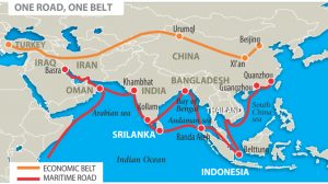
As a net result, for over a decade, China has chafed under the opprobrium heaped upon it for a concept that (to be fair) it had never once articulated by the state. However, in a brilliant rebranding exercise by Beijing in 2014, the world’s attention is being increasingly drawn away from the negative connotations associated with the phrase String of Pearls and towards the more benign-sounding 21st century Maritime Silk Route Economic Belt, also known as “One Road, One Belt.” This presents an alternative expression, while it nevertheless covers essentially the very same geostrategic maritime game-plays that Colonel Pehrson explained a decade ago. The new expression emphasizes transregional inclusiveness and evokes the romance of a shared pan-Asian history with the implied promise of a reestablishment of the economic prosperity that the Asian continent’s major civilizational and socio-cultural entities, namely China and India, enjoyed until the 18th century.

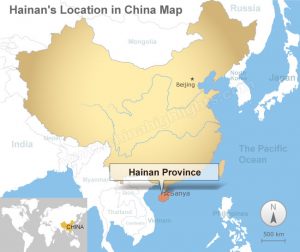
Each “pearl” in the String of Pearls construct—or in more contemporary parlance, each “node” along the Maritime Silk Route—is a link in a chain of Chinese geopolitical and geostrategic influence. For example, Hainan Island, with its recently upgraded military facilities and sheltered submarine base, is a pearl/node.

It is by no means necessary for a line joining these pearls/nodes to encompass mainland China in one of the concentric ripples typified by the Island Chains strategy. In fact, since the Maritime Silk Route is a true maritime construct, it is highly unlikely that the nodes would do so.

Image Courtesy: chinahighlights.com
The location of Hainana Province, China. (chinahighlights.com)

Other pearls/nodes include the recent creation of artificial islands in the Paracel and Spratly islands incorporating, inter alia, the ongoing construction/upgrade of airstrips on Woody Island—located in the Paracel Islands, some 300 nm east of Vietnam—as also on Mischief Reef and Fiery Cross Reef in the Spratly Islands. Additional pearls/nodes have been obtained through Chinese investments in Cambodia and China’s continuing interest in Thailand’s Isthmus of Kra.

China’s development of major maritime infrastructure abroad—the container terminal in Chittagong, Bangladesh; the Maday crude oil terminal in Myanmar’s Kyakpyu port; the development of ports such as Hambantota in Sri Lanka, Gwadar in Pakistan, Bagamoyo in Tanzania, Beira in Mozambique, Walvis Bay in Namibia, Kribi in Cameroon, the Djibouti Multipurpose Port (DMP), and the offer to even develop Chabahar in Iran (checkmated by a belated but vigorous Indian initiative), along with the successful establishment of a military (naval) base in Djibouti—all constitute yet more pearls/nodes. The development of an atoll in the Seychelles, oil infrastructure projects in Sudan and Angola, and the financing of newly discovered massive gas finds in offshore areas of Mozambique, Tanzania and the Comoros, are similarly recently acquired pearls/nodes. Even Australia yields a pearl/node, as does South Africa, thanks to Chinese strategic investment in mining in general and uranium-mining companies in particular, in both countries.

Chinese maritime policing vessel.
Chinese maritime policing vessel. (SCMP.com)

From an Indian perspective, China’s new strategic maritime-constructs (by whichever name) are simultaneously operative on a number of levels, several of which are predominantly economic in nature and portend nothing more than fierce competition. At the geostrategic level, however, the economy is at its apex and is China’s and India’s greatest strength and greatest vulnerability, at the same time; therefore, the economy is the centerpiece of the policy and strategy of both countries. This is precisely why, as the geographical competition space between India and China coincide in the Indian Ocean, there is a very real possibility of competition transforming into conflict, particularly as the adverse effects of climate change on resources and the available land area becomes increasingly more evident.

“Reach” has both spatial and temporal dimensions. The spatial facets of China’s geopolitical moves are evident, as illustrated in the preceding String of Pearls discussion. It is critical for India’s geopolitical and military analysts to also understand the temporal facets of this construct. The terms short term, medium term and long term are seldom used with any degree of digital precision. A nation tends to keep its collective “eye on the ball” in the short term and, by corollary, tends to assign far less urgency to something that is assigned to the long term. This ill-defined differentiation is how strategic surprise may be achieved in the temporal plane. For instance, in China, the short term generally implies 30 to 50 years. This is an epoch that is far in excess of what in India passes as the long term. Consequently, India fails to pay as close attention to developments in China as she might have were the developments to unfold in a duration corresponding to India’s own short term of 2-5 years. This distinction permits China to achieve strategic surprise, and this is as true of military strategy as it is of grand strategy and geoeconomics.

On the one hand, it should be remembered that these strategic constructs are not only about maritime infrastructure projects, involving the construction of ports, pipelines and airfields, though these developments constitute their most obvious and visibly worrisome manifestation. The strategy is equally about new, renewed or reinvigorated geopolitical and diplomatic ties between the People’s Republic of China and nation states across a very wide geographical swath (including the African littoral and the island nations of both the Indian Ocean and the Pacific Ocean). On the other hand, China’s strategic maritime constructs have some important military spin-offs, which closely align to the furtherance of geostrategic reach. Thus, by developing friendly ports of call (if not bases), facilities and favorable economic dependencies in the various pearls/nodes, the logistics involved in the event of an engagement in maritime power-projection are greatly eased.

1_091223153841_1
Type 904 (Dayun Class) Transport Ship (globalmil.com)

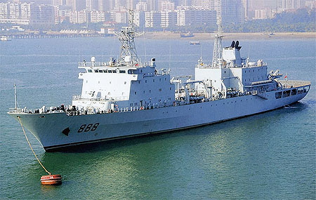
Supplementing the pearls/nodes are the Chinese Navy’s five impressive stores/ammunition supply ships of the Dayun Class (Type 904) and six underway replenishment tankers of the Qiandaohu Class (Type 903A). In addition, China requires ground control stations to meet her satellite-based needs of real-time surveillance. Unlike the United States, China simply does not have adequate ground control/tracking stations within the Indian Ocean to affect requisite ground control and real-time downlinking of her remote-sensing satellites. This forces her to deploy a number of ships (the Yuanwang Class) for this purpose. These constitute a severe vulnerability that China certainly needs to overcome. One way to do so is to establish infrastructure and acceptability along the IOR island states and along the East African littoral, as China is currently attempting to do.

The principal lack in the Chinese strategy to provide military substance to the country’s geoeconomic and geostrategic reach comes in the form of integral air power through aircraft carriers. China is rapidly learning that while one can buy or build an aircraft carrier in only a couple of years, it takes many more years to develop the human, material, logistic and doctrinal skills required for competent and battle worthy carrier-borne aviation. For nearly a decade now, China has demonstrated her ability to sustain persistent military (naval) presence in the Indian Ocean—albeit in a low threat environment. Combat capability is, of course, quite different from mere presence or even the ability to maintain anti-piracy forces, since the threat posed to China by disparate groups of poorly armed, equipped and led pirates can hardly be equated with that posed by a powerful and competent military adversary in times of conflict.

Despite the impressive growth of the Chinese Navy and the vigor of the Chinese military strategy, China may not, in the immediate present, have the combat capability to deploy for any extended period of time in support of its geoeconomic and geostrategic reach were they to be militarily contested by a major navy. However, as James Holmes points out, if India were to continue to cite shortfalls in current Chinese capability and conclude that it will take the PLA Navy at least fifteen years to station a standing, battle worthy naval squadron in the Indian Ocean, this would lull Indians into underplaying Chinese determination and the speed of that country’s military growth. This would carry the very real consequent possibility of India suffering a massive strategic surprise. Is that something that India can afford?

Vice Admiral Pradeep Chauhan retired as Commandant of the Indian Naval Academy at Ezhimala. He is an alumnus of the prestigious National Defence College.

US Department of State Seeks to Clarify Meaning of China’s 9-Dash Line Part 3

By Alex Calvo

This is the third installment in a five-part series summarizing and commenting the 5 December 2014 US Department of State “Limits in the Seas” issue explaining the different ways in which one may interpret Chinese maritime claims in the South China Sea. It is a long-standing US policy to try to get China to frame her maritime claims in terms of UNCLOS. Read part one, part two

[otw_shortcode_button href=”https://cimsec.org/buying-cimsec-war-bonds/18115″ size=”medium” icon_position=”right” shape=”round” color_class=”otw-blue”]Donate to CIMSEC![/otw_shortcode_button]

Let us move to the three interpretations put forward by the US Department of State.

1.- “Dashed Line as Claim to Islands”

This would mean that all Beijing was claiming were the islands within the dashed lines, and that any resulting maritime spaces would be restricted to those recognized under UNCLOS and arising from Chinese sovereignty over these islands. The text notes that “It is not unusual to draw lines at sea on a map as an efficient and practical means to identify a group of islands”. In support of this interpretation one could take the map attached to the 2009 Notes Verbales and the accompanying text, which reads “China has indisputable sovereignty over the islands in the South China Sea and the adjacent waters, and enjoys sovereign rights and jurisdiction over the relevant waters as well as the seabed and subsoil thereof (see attached map)”. The text notes that the references in the paragraph above to “sovereignty” over “adjacent” waters” may be interpreted as referring to a 12-nm belt of territorial sea, since international law recognizes territorial waters as being a sovereignty zone. In a similar vein, references to “sovereign rights and jurisdiction”, “relevant waters”, and “seabed and subsoil thereof”, would then be taken to concern the legal regime of the EEZ and the continental shelf, as defined by UNCLOS.

As possible evidence for this interpretation, the study cites some Chinese legislation, cartography, and statements. The former includes Article 2 of the 1992 territorial sea law, which claims a 12-nm territorial sea belt around the “Dongsha [Pratas] Islands, Xisha [Paracel] Islands, Nansha (Spratly) Islands and other islands that belong to the People’s Republic of China”. This article reads “The PRC’s territorial sea refers to the waters adjacent to its territorial land. The PRC’s territorial land includes the mainland and its offshore islands, Taiwan and the various affiliated islands including Diaoyu Island, Penghu Islands, Dongsha Islands, Xisha Islands, Nansha (Spratly) Islands and other islands that belong to the People’s Republic of China. The PRC’s internal waters refer to the waters along the baseline of the territorial sea facing the land”. The Department of State also stresses that China’s 2011 Note Verbale states that “China’s Nansha Islands is fully entitled to Territorial Sea, Exclusive Economic Zone (EEZ), and Continental Shelf”, without laying down any other maritime claim. Concerning cartography, the study cites as an example the title of “the original 1930s dashed-line map, on which subsequent dashed-line maps were based”, which reads, “Map of the Chinese Islands in the South China Sea” (emphasis in the DOS study). With regard to Chinese statements, the study cites the country’s 1958 declaration on her territorial sea, which reads “and all other islands belonging to China which are separated from the mainland and its coastal islands by the high seas” (emphasis in the DOS study). The text argues that this reference to “high seas” means that China could not be claiming the entirety of the South China Sea, since should that have been the case there would have been no international waters between the Chinese mainland and her different islands in the region. This is a conclusion with which it is difficult to disagree, although we should not forget that it was 1958, with China having barely more than a coastal force rather than the present growing navy. Therefore, while the study’s conclusion seems correct, and precedent is indeed important in international law, it is also common to see countries change their stance as their relative power and capabilities evolve. Thus, if China had declared the whole of the South China Sea to be her national territory in 1958 this would have amounted to little more than wishful thinking, given among others the soon to expand US naval presence in the region and extensive basing arrangements. Now, 50 years later, with China developing a blue water navy, and the regional balance of power having evolved despite the US retaining a significant presence, Beijing can harbor greater ambitions.

6
Then US Secretary of State Hillary Clinton with her Filipino counterpart, Albert del Rosario, in June 2011. Washington supports Manila’s arbitration bid and rearmament, but takes no official position on her territorial claims, despite involving former American territory.

This section ends with the DOS study stating that should this interpretation be correct, then “the maritime claims provided for in China’s domestic laws could generally be interpreted to be consistent with the international law of the sea”. This is subject to two caveats, territorial claims by other coastal states over these islands, and Chinese ambiguity concerning the nature of certain geographical features, Beijing not having “clarified which features in the South China Sea it considers to be ‘islands’ (or, alternatively, submerged features) and also which, if any, ‘islands’ it considers to be ‘rocks’ that are not entitled to an EEZ or a continental shelf under paragraph 3 of Article 121 of the LOS Convention”. Some of these features, Scarborough Reef for example, are part of the arbitration proceedings initiated by the Philippines.

2.- “Dashed Line as a National Boundary”

This would mean that Beijing’s intention with the dashed line was to “indicate a national boundary between China and neighboring States”. As supporting evidence for this interpretation, the DOS report explains that “modern Chinese maps and atlases use a boundary symbol to depict the dashed line in the South China Sea”, adding that “the symbology on Chinese maps for land boundaries is the same as the symbology used for the dashes”. Map legends translate boundary symbols as “either ‘national boundary’ or ‘international boundary’ (国界, romanized as guojie)”. Chinese maps also employ “another boundary symbol, which is translated as ‘undefined’ national or international boundary (未定国界, weiding guojie)” but this is never employed for the dashed line.

The report stresses that, under international law, maritime boundaries must be laid down “by agreement (or judicial decision) between neighboring States”, unilateral determination not being acceptable. The text also notes that the “dashes also lack other important hallmarks of a maritime boundary, such as a published list of geographic coordinates and a continuous, unbroken line that separates the maritime space of two countries”. The latter is indeed a noteworthy point, since border lines would indeed seem to need to be continuous by their very nature, rather than just be made up of a number of dashes. This is one of the aspects making it difficult to fit Beijing’s claims with existing categories in the law of the sea. In addition, the report notes that they cannot be a limit to Chinese territorial waters, since they extend beyond 12 nautical miles, and neither can they be a claim to an EEZ, since “dashes 2, 3, and 8” are “beyond 200 nm from any Chinese-claimed land feature”. These last two aspects also make it difficult to see the dashed line as marking one of the categories recognized by UNCLOS. Moving beyond the law, however, and this is something that the DOS report does not address, a certain degree of ambiguity may be seen as beneficial by a state seeking to gradually secure a given maritime territory. Some voices have noted this may have been the US calculus in the San Francisco Treaty. Thus, the technical faults, from an international legal perspective, in China’s dotted line are not necessarily an obstacle to Beijing’s claims, from a practical perspective.

Read the next installment here

Alex Calvo is a guest professor at Nagoya University (Japan) focusing on security and defence policy, international law, and military history in the Indian-Pacific Ocean. Region. A member of the Center for International Maritime Security (CIMSEC) and Taiwan’s South China Sea Think-Tank, he is currently writing a book about Asia’s role and contribution to the Allied victory in the Great War. He tweets @Alex__Calvo and his work can be found here.

[otw_shortcode_button href=”https://cimsec.org/buying-cimsec-war-bonds/18115″ size=”medium” icon_position=”right” shape=”round” color_class=”otw-blue”]Donate to CIMSEC![/otw_shortcode_button]

China’s South China Sea Strategy: Simply Brilliant

This article can be found in its original form at ASPI here, and was republished with permission.

In the past 12 months, China has provoked considerable attention with its reclamation activities in the South China Sea, particularly in the Spratlys where it controls seven maritime features.

China’s history of salami-slicing presents a dilemma to regional countries as well as external powers with regional interests: do they escalate an incident each time China slices the salami and risk open conflict, or stand down and allow China to augment its territorial claims.

The million-dollar question remains: who or what will freeze China’s reclamation in the South China Sea? The answer: nothing, really.

It has been proposed, for example, that like-minded states carve out a ‘code of practice’ that would stress the rule of law and mirror the 2002 Declaration on the Conduct of Parties in the South China Sea. Another option being considered by the Pentagon is to send US aircraft and ships within 12 nautical miles of the Chinese-built reefs in the Spratlys, to challenge its influence there.

While useful, such proposals won’t freeze or rollback China’s attempts to change the facts on the ground (or the high sea). China’s reclamation seeks to pre-empt any decision that would come from the Philippines’ challenge in the International Tribunal for the Law of the Sea over China’s nine-dash line claim to the South China Sea.

It’s noteworthy that China hasn’t only engaged in salami slicing; it has sought to use the attraction of its economy, trade and aid to offset its high-risk behaviour.

Following the 2012 Scarborough Shoal incident with the Philippines, China launched a charm offensive in 2013, wooing ASEAN with a treaty of friendship and cooperation, stressing that it intended to take China–ASEAN relations from a ‘golden decade’ to a ‘diamond decade’.

This year, when concerns about China’s reclamation have intensified, China has offered a carrot: US and other countries would be welcome to use civilian facilities it’s building in the South China Sea for search and rescue and weather forecasting, when ‘conditions are right’.

China has also used its economic weight to deftly tilt the balance (of influence, at least) in its favor. Its Asian Infrastructure Investment Bank (AIIB) is attracting long-standing American allies such as Great Britain, Australia and South Korea. China has stolen a march on the US in the battle to win friends and influence people.

And the economic offensive doesn’t end with the AIIB. The Regional Comprehensive Economic Partnership—a free trade agreement that would involve ASEAN, Australia, China, India, Japan, New Zealand and South Korea—is seen as a rival to the US-led Trans-Pacific Partnership. China’s Silk Road Economic Belt is also another lure for peripheral countries keen on leveraging on China’s economic ascent.

Concerted and effective opposition to China’s fait accompli in the South China Sea requires an astute mix of diplomacy and deterrence. It might take the form of a regional effort to get China to clarify its nine-dashed line claims based on UNCLOS principles, an ASEAN ultimatum for China to at least freeze its reclamation activities, and joint ASEAN–US patrols near the reefs being reclaimed by China. This looks unlikely to emerge anytime soon.

ASEAN was damaged in 2012, when it failed—for the first time in its 45-year history—to issue a communiqué due to differing views over the South China Sea. ASEAN has recently upped its game by underscoring the dangers of China’s reclamation, but there’s little the group can do apart from pushing for a formal Code of Conduct. A successful conclusion of the code isn’t assured; China dangles the carrot of code negotiations to buy time even as its carries out reclamation.

For all its rhetoric about the need to uphold international law and the freedom of navigation, the US is conflicted when it comes to China. It all boils down to this: will the US risk its extensive relationship with China over a few rocks in the South China Sea? As Hillary Clinton once said: how does the US ‘deal toughly’ toward its banker?

To get a sense of the effect of China’s creeping invasion of the South China Sea, one only need look at Vietnam. Faced with China’s challenge to its claims to the Paracel Islands, Vietnam has purchased Kilo-class submarines, reportedly armed with sub-launched land-attack Klub missiles that could threaten Chinese coastal targets. But Vietnam didn’t fire a shot when China towed a US$1b oil rig into waters claimed by Vietnam last year. On a recent trip to Hanoi, Vietnamese scholars told me that Vietnamese military officers urged sterner action, such as firing on Chinese ships, but senior leaders vetoed them, instead deciding to sit back and let China incur ‘reputational damage’.

Not many people in Asia would agree with what China is doing in the South China Sea. But as it stands, China’s strategy—salami slicing, using offsets to soften risky behavior and accelerating its reclamation activities in the absence of significant opposition—can be summed up in two words: simply brilliant.

William Choong is a Shangri-La Dialogue senior fellow for Asia-Pacific Security at the International Institute for Strategic Studies.

An ASEAN Maritime Alliance?

The year 2014 brought new tensions to the South China Sea, particularly as Chinese authorities sought to establish a series of island-like structures in the midst of the disputed Spratly Islands. Such provocative actions, however, are unlikely to generate sufficient political will among the other countries of the region to establish a Political-Security Community under the auspices of the Association of South East Asian Nations (ASEAN) by the 2015 deadline. But were this collection of ten countries to pool their resources into a security community or even a security alliance, it would be an impressive force and a potential deterrent to aggression in the South China Sea.

In particular, it is worthwhile noting the relative strength of ASEAN coastal defence forces. Some member states, such as Indonesia, possess respectable ‘blue water’ navies, that is to say, they have larger vessels capable of operating in deep waters and engaging in long-range standing battles. Other ASEAN countries, such as the Philippines, have considerable ‘brown water’ navies,  forces consisting of small patrol boats which can cruise inland waterways and the shallow waters that weave between tight-knit island chains. But the varied nature of the waters disputed in the South China Sea particularly requires the flexibility offered by corvettes.

Generally, corvettes fall between the Royal Canadian Navy’s Halifax-class frigates and Kingston-class coastal defence vessels in size. But there is much debate as to what constitutes a contemporary corvette. For example, the Royal Omani Navy calls its Khareef-class vessels ‘corvettes’ even though the displacement of each vessel in the class is approximately 2,660 tons. Recent advancements in shipbuilding have also allowed the US Navy to introduce new vessels with substantial displacement but with shallower drafts, meaning the new USS Liberty can approach closer to coastlines than the similarly sized but older Oliver Hazard Perry-class frigates.

For the purposes of this analysis, only those vessels with a displacement greater than 100 tons but less than 1,700 tons will be considered corvettes. China’s maritime forces, the People’s Liberation Army Navy (PLAN),  has a substantial number of vessels in this range deployed to Hong Kong and a network of naval bases off the South China Sea. 12 Jiangdao-class corvettes (1,440 tons) are the workhorses of this maritime presence in the region and China may possibly add 3 more vessels of this class by the end of 2015. Beyond the Jiangdao-class corvettes, PLAN’s southern presence includes six Houjian-class missile boats (520 tons) and approximately 80 other missile boats and gunboats of various classes and ranging in displacement from 200 to 480 tons each. This vastly exceeds the quantity and quality of vessels any individual Southeast Asian country could bring to bear in a conflict. But ASEAN’s combined maritime forces could meet the challenge presented by a limited PLAN offensive.

Brunei in particular has emerged as a promising new maritime actor in the region, even actively participating in the 2014 edition of the Rim of the Pacific Exercise (RIMPAC). The Royal Brunei Navy acquired four specially built Darussalam-class offshore patrol ships (1,625 tonnes) from the German shipbuilder Luerssen-Werft, which replaced Brunei’s previous coastal defence workhorse, the Waspada-class fast attack craft (200 tonnes). The Waspada-class vessels have since been decommissioned and donated to Indonesia to be used for training purposes. The introduction of the Darussalam-class greatly upgrades Brunei’s defence capabilities and it will be of interest for Southeast Asian observers to see how Brunei further pursues the modernization of its forces.

The Republic of Singapore Navy has much in the way of heavier frigates and submarines to defend its unique position by the Strait of Malacca, one of the world’s most significant shipping routes. Its corvette-like vessels are also impressive, six Victory-class corvettes (600 tonnes) and 12 Fearless-class offshore patrol ships (500 tonnes), but they are certainly not as new as some of the vessels boasted by Singapore’s neighbours. The Victory-class was acquired in 1990-1991 while the Fearless-class was introduced between 1996 and 1998. Therefore, it will also be of interest to see whether Singapore seeks to obtain any newer vessels which can serve as a bridge in capabilities between the Victory-class corvettes and the heavier Formidable-class frigates.

dsc_5220It is Thailand, the Philippines, and Indonesia that boast the largest complements of corvettes in the region, however. The Royal Thai Navy’s coastal defence is led by two Tapi-class corvettes (1,200 tons) and two Pattani-class offshore patrol ships (1,460 tons), which are joined by two Ratanakosin-class corvettes (960 tons), three Khamrosin-class corvettes (630 tons), three Hua Hin-class patrol boats (600 tons), six PSMM Mark 5-class patrol boats (300 tons), and 18 smaller patrol boats and fast attack boats of varying capabilities but all rather aged. The Philippines and Indonesia both have vast island chains within their respective territories, requiring corvettes and smaller patrol vessels just as much for counter-trafficking and counter-piracy operations as for countering conventional maritime forces. The Philippine Navy possesses one Pohang-class corvette (1,200 tons), two Rizal-class corvettes (1,250 tons), nine Miguel Malvar-class corvettes (900 tons), and three Emilio Jacinto-class corvettes (700 tons). Indonesia tops out ASEAN’s array of corvettes with three Fatahillah-class corvettes (1,450 tons), 16 Kapitan Patimura-class corvettes (950 tons), and 65 other missile boats and gunboats with a displacement of approximately 100-250 tons.

Yet it is unclear how much of their forces Indonesia or the Philippines would be able to deploy in the midst of a South China Sea conflict. As mentioned previously, many of these vessels have been used practically as inland patrol vessels. There are also some potential weak links in the chain should ASEAN establish some form of formalized maritime alliance. The Royal Malaysian Navy only offers four Laksamana-class corvettes (675 tons) and an array of 16 smaller missile boats and gun boats that could generally only be used to harass Chinese forces. Burma certainly has an impressive force in its own right – consisting of three domestically produced Anawratha-class corvettes (1,100 tons), six Houxin-class missile boats (500 tons), 10 5 Series-class missile boats (500 tons), and 15 Hainan-class gunboats (450 tons), but the military junta has already demonstrated that it will remain aloof from territorial disputes in the South China Sea and generally supports China’s policy toward Southeast Asia.

The Royal Cambodian Navy is in shambles, consisting solely of five outdated Turya-class torpedo boats (250 tons), five Stenka-class patrol boats (250 tons), and a lone Shershen-class fast attack boat (175 tons). But Cambodian authorities would be just as disinclined to engage in defence sharing as their Burmese counterparts. During Cambodia’s 2012 ASEAN chairmanship, Cambodian officials consistently interfered in efforts by other ASEAN member states to reach a common position on the South China Sea’s territorial disputes. Given the understanding on security issues shared between Cambodian and Chinese officials, as well as China’s status as Cambodia’s largest source of foreign investment and aid, it is apparent that Cambodia has relatively no need for the security guarantees ASEAN could provide as a regional counter-balance to China.

Vietnam is the unpredictable factor in the region. The Vietnam People’s Navy has a few corvettes of its own, including a Pauk-class corvette (580 tons), eight Tarantul-class corvettes (540 tons), and 23 patrol ships with displacements ranging from 200 to 375 tons. The Vietnamese government has also ordered two more TT-400TP gunboats (450 tons) from domestic shipbuilders with delivery expected in late 2015 or early 2016. This leaves Vietnam with a force perhaps not as sizable as that of Indonesia or the Philippines but with greater capacity to intervene should China seek to settle territorial disputes with Vietnam by force.

As Malaysia will hold the 2015 Chairmanship of ASEAN, the prospects for a maritime force in support of the bloc’s proposed Political-Security Community will depend to some degree on whether Malaysian officials will be willing to show leadership. If Malaysia looks to acquire new vessels and insists on placing maritime security on the agenda of upcoming ASEAN meetings, some arrangement could be struck by the end of the year. But this will require artful diplomacy, especially in the face of Burmese and Cambodian opposition. With Malaysian officials speaking predominantly about the need for a single market in the region and promoting a conclusion to negotiations regarding the Regional Comprehensive Economic Partnership, such a drive for maritime security may not be forthcoming.

Paul Pryce is a Research Analyst at the Atlantic Council of Canada. His research interests are diverse and include maritime security, NATO affairs, and African regional integration.

This article can be found in its original form at the  
NATO Council of Canada and was republished by permission.