Recorded along the sidelines of this year’s Shangri-La
Dialogue in Singapore, find out how the region’s top strategic thinkers reacted to the big speeches, the posturing of the U.S. and China, the way forward on maritime disputes and the other security challenges we should be paying attention to like ISIS and climate change.
SINGAPORE (June 4, 2016) Secretary of Defense Ash Carter greets Japanese Minister of Defense Gen Nakatani and South Korean Defence Minister Han Min-goo prior to a trilateral meeting in Singapore, June 4, 2016. (DoD photo by Navy Petty Officer 1st Class Tim D. Godbee)(Released)
Natalie Sambhi interviews an all-star cast featuring Professor Rommel Banlaoi (Philippine Institute for Peace, Violence and Terrorism Research), Mr. Graeme Dobell (Australian Strategic Policy Institute), Ms. Bonnie Glaser (Center for Strategic and International Studies), Dr. Euan Graham (Lowy Institute for International Policy, Australia), Ms. Mercedes Page (Australian Strategic Policy Institute), Ms. Janet Dyah Ekawati (independent defence consultant, Indonesia) and Mr. Dzirhan Madadzir (Janes Defence Weekly, Malasysia).
This is the fifth installment in a five-part series summarizing and commenting the 5 December 2014 US Department of State “Limits in the Seas” issue explaining the different ways in which one may interpret Chinese maritime claims in the South China Sea. It is a long-standing US policy to try to get China to frame her maritime claims in terms of UNCLOS. Read part one, part two, part three, part four.
[otw_shortcode_button href=”https://cimsec.org/buying-cimsec-war-bonds/18115″ size=”medium” icon_position=”right” shape=”round” color_class=”otw-blue”]Donate to CIMSEC![/otw_shortcode_button]
Whereas the assertion that China has not actually made a claim may not be shared by everybody, in particular given the language flowing from Beijing which the DOS report itself cites, the reference to the “high seas” between mainland China and some islands seems stronger proof that Beijing was not making a historic claim. However, we must again stress that this would be the case if we followed the prevailing interpretation of the law of the sea, but there is no reason why China should adhere strictly to it, and even less that Beijing should not have changed her mind since 1958, when she had little more than a coastal navy and her economy was closed and in tatters. It may be true, as the report notes, that the 1958 Declaration only made a historic claim to the Bohai (Pohai) gulf in northeastern China, but again this should perhaps be judged from a wider historical perspective. After 1949 the PRC took a much more uncompromising stance concerning its North-East than its South-East (and wider maritime) borders. With a pragmatic arrangement in place with the United Kingdom concerning Hong Kong, and a strong economic and political relation with the Soviet Union, it was at the other end of the country where, in 1950, Beijing (not without an intense internal debate given the state of the country), decided to resort to force to prevent the presence of hostile forces close to her border, intervening in the Korean War, pushing back the advancing Allied forces and reversing the impact of the Inchon landing, ultimately forcing a stalemate on the ground. In 1958, just five years after the Korean armistice, nearby waters may have thus been much more present in Chinese leaders’ minds. In addition, these were also the waters directly leading to Tianjin and Beijing, the venue for foreign interventions in both the Opium Wars and the Taiping Rebellion. It would not be until the late 1970s that China’s South-Eastern flank would begin to receive more attention, in part thanks to the rapprochement with the United States and in particular once economic growth and the country’s move to become a net energy and commodity importer turned the waters of the South China Sea into a vital venue and potential choke point. It is true that in December 1941 the loss of HMS Prince of Wales and HMS Repulse in the South China Sea had enabled the Japanese to land in Malaya and ultimately conquer Burma, closing the last land route to besieged Nationalist China, but this did not result in a comparable imprint on China’s historical consciousness, among other reasons because the episode did not involve Chinese naval forces and was subsumed into a much larger, dramatic, and quickly-developing picture.
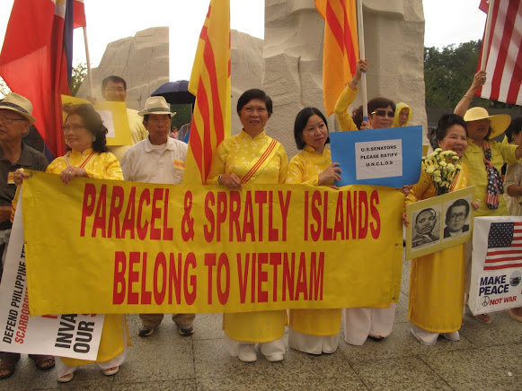
Vietnamese-Americans demonstrating against Chinese claims in the South China Sea. Note the banner in favor of US ratification of UNCLOS.
Rejecting the validity of a possible historic claim by China. Concerning whether, if China “Made a Historic Claim”, it would “have Validity”, the DOS paper insists that “such a claim would be contrary to international law”, stressing the limited degree to which UNCLOS recognizes this category of claims, as evidenced by its “text and drafting history”. The text argues that “apart from a narrow category of near-shore ‘historic’ bays” in Article 10, and “historic title” concerning “territorial sea boundary delimitation (Article 15)”, “modern international law of the sea does not recognize history as the basis for maritime jurisdiction”, citing the Gulf of Maine ICJ case. It also underlines the fact that UNCLOS provisions concerning the EEZ, continental shelf, and the high seas “do not contain any exceptions for historic claims” to the detriment of coastal states and all estates enjoying certain freedoms. Concerning fisheries, the report acknowledges that UNCLOS refers to “the need to minimize economic dislocation in States whose nationals have habitually fished” in the EEZ (Article 62(3)) and to “traditional fishing rights and other legitimate activities” (Article 51), but restricts the impact to the possible granting by one state to another of fisheries resources “based on prior usage”. The text stresses that no such traditional fishing practices can “provide a basis for sovereignty, sovereignty rights, or jurisdiction,” adding that UNCLOS rules on oil and gas development contain no “exception for historic rights in any context.” Again we note how a purely legal report like this may be missing part of the picture, given the great importance that fishing vessels have in the ongoing conflict over the South China Sea, where they are one of the pillars of asymmetric naval warfare.
Chinese scholars Gao and Jia have argued that UNCLOS does not regulate “historic title” and “historic rights,” which fall instead under the purview of general international law. In their view, UNCLOS “was never intended, even at the time of its adoption, to exhaust international law. On the contrary, it has provided ample room for customary law to develop and to fill in the gaps that the Convention itself was unable to fill in 1982” as clear from its preamble, which reads “matters not regulated by this Convention continue to be governed by the rules and principles of general international law.” The DOS report explicitly rejects this position, saying that “it is not supported by international law” and goes against the “comprehensive scope of the LOS Convention.” Experts like Mark Valencia, on the other hand, hold that China’s posture may be compatible with the international law of the sea.
The text does not stop at arguing that it is not open to a state to make historic claims based not on UNCLOS but on general international law, laying down a second line of defense. It explains that, “even assuming that a Chinese historic claim in the South China Sea were governed by ‘general international law’ rather than the Convention,” it would still be invalid since it would not meet the necessary requirements under general international law, namely “open, notorious, and effective exercise of authority over the South China Sea,” plus “continuous exercise of authority” in those waters and “acquiescence by foreign States” in such exercise of authority. Furthermore, it explains that the United States, which “is active in protesting historic claims around the world that it deems excessive,” has not protested “the dashed line on these grounds, because it does not believe that such a claim has been made by China,” with Washington choosing instead to request a clarification of the claim. Whether this view is also meant to avoid a frontal clash with Beijing, in line with the often state policy goal of “managing” rather than “containing” China’s rise, is something not discussed in the text.
The report concludes by criticizing another view put forward by Gao and Jia, namely the relevance of claims made before the advent of UNCLOS. While these two scholars argue that “In the case of the South China Sea as enclosed by the nine-dash line, China’s historic title and rights, which preceded the advent of UNCLOS by many years, have a continuing role to play,” the DOS paper says that “The fact that China’s claims predate the LOS Convention does not provide a basis under the Convention or international law for derogating from the LOS Convention,” adding that “permitting States to derogate from the provisions of the Convention because their claims pre-date its adoption is contrary to and would undermine” the convention’s “object and purpose” stated in its preamble to “settle … all issues relating to the law of the sea.”
Conclusions. Long-standing American policy towards China stresses the need to manage the latter’s rise, so that it does not threaten the post-Second World War system, based among others on freedom of navigation and a ban on territorial expansion as a legitimate causus belli. As a result, Washington has often called on Beijing to clarify her claims on the South China Sea, in an attempt to constrain them while avoiding a frontal clash. This position also seeks to reinforce the perception that the United States focuses on the rule of law at sea, rather than on supporting one claimant against the other over disputed waters. The DOS document, in line with this approach, carefully dissects Chinese claims, analyzing whether they may be compatible with standard American interpretations of international Law of the Sea. The conclusions are rather pessimistic, exposing how, despite having ratified UNCLOS, the Convention’s provisions are not seen in the same light by Beijing and Washington. This should not surprise us, since international law seeks to constrain power but at the same time it is shaped by it, thus as countries rise they seek to play a greater role in the fate of rules and principles. In the case of China this is even clearer due to historical perceptions that it was to a large extent seaborne power which subjected the country to a semi-colonial status for a whole century. If Beijing’s claims in the South Chinese Sea cannot be seen in the light of UNCLOS, the question arises what ultimate Chinese goals are. Could this be the subject of a future paper by the Department of State? Or does Washington prefer to wait until the international arbitration case launched by Manila concludes? While the second option seems more likely, as time goes by the idea that China’s rise may be shaped, rather than constrained, increasingly seems less and less realistic. However, if the time comes to draw a line in the sand, a whole of government effort will be needed, going beyond the naval circles that to date have been most vocal in articulating the need to resist Chinese expansion.
Alex Calvo is a guest professor at Nagoya University (Japan) focusing on security and defence policy, international law, and military history in the Indian-Pacific Ocean. Region. A member of the Center for International Maritime Security (CIMSEC) and Taiwan’s South China Sea Think-Tank, he is currently writing a book about Asia’s role and contribution to the Allied victory in the Great War. He tweets @Alex__Calvo and his work can be foundhere.
[otw_shortcode_button href=”https://cimsec.org/buying-cimsec-war-bonds/18115″ size=”medium” icon_position=”right” shape=”round” color_class=”otw-blue”]Donate to CIMSEC![/otw_shortcode_button]
This is the third installment in a five-part series summarizing and commenting the 5 December 2014 US Department of State “Limits in the Seas” issue explaining the different ways in which one may interpret Chinese maritime claims in the South China Sea. It is a long-standing US policy to try to get China to frame her maritime claims in terms of UNCLOS. Read part one, part two.
[otw_shortcode_button href=”https://cimsec.org/buying-cimsec-war-bonds/18115″ size=”medium” icon_position=”right” shape=”round” color_class=”otw-blue”]Donate to CIMSEC![/otw_shortcode_button]
Let us move to the three interpretations put forward by the US Department of State.
1.- “Dashed Line as Claim to Islands”
This would mean that all Beijing was claiming were the islands within the dashed lines, and that any resulting maritime spaces would be restricted to those recognized under UNCLOS and arising from Chinese sovereignty over these islands. The text notes that “It is not unusual to draw lines at sea on a map as an efficient and practical means to identify a group of islands”. In support of this interpretation one could take the map attached to the 2009 Notes Verbales and the accompanying text, which reads “China has indisputable sovereignty over the islands in the South China Sea and the adjacent waters, and enjoys sovereign rights and jurisdiction over the relevant waters as well as the seabed and subsoil thereof (see attached map)”. The text notes that the references in the paragraph above to “sovereignty” over “adjacent” waters” may be interpreted as referring to a 12-nm belt of territorial sea, since international law recognizes territorial waters as being a sovereignty zone. In a similar vein, references to “sovereign rights and jurisdiction”, “relevant waters”, and “seabed and subsoil thereof”, would then be taken to concern the legal regime of the EEZ and the continental shelf, as defined by UNCLOS.
As possible evidence for this interpretation, the study cites some Chinese legislation, cartography, and statements. The former includes Article 2 of the 1992 territorial sea law, which claims a 12-nm territorial sea belt around the “Dongsha [Pratas] Islands, Xisha [Paracel] Islands, Nansha (Spratly) Islands and other islands that belong to the People’s Republic of China”. This article reads “The PRC’s territorial sea refers to the waters adjacent to its territorial land. The PRC’s territorial land includes the mainland and its offshore islands, Taiwan and the various affiliated islands including Diaoyu Island, Penghu Islands, Dongsha Islands, Xisha Islands, Nansha (Spratly) Islands and other islands that belong to the People’s Republic of China. The PRC’s internal waters refer to the waters along the baseline of the territorial sea facing the land”.The Department of State also stresses that China’s 2011 Note Verbale states that “China’s Nansha Islands is fully entitled to Territorial Sea, Exclusive Economic Zone (EEZ), and Continental Shelf”, without laying down any other maritime claim. Concerning cartography, the study cites as an example the title of “the original 1930s dashed-line map, on which subsequent dashed-line maps were based”, which reads, “Map of the Chinese Islands in the South China Sea” (emphasis in the DOS study). With regard to Chinese statements, the study cites the country’s 1958 declaration on her territorial sea, which reads “and all other islands belonging to China which are separated from the mainland and its coastal islands by the high seas” (emphasis in the DOS study). The text argues that this reference to “high seas” means that China could not be claiming the entirety of the South China Sea, since should that have been the case there would have been no international waters between the Chinese mainland and her different islands in the region. This is a conclusion with which it is difficult to disagree, although we should not forget that it was 1958, with China having barely more than a coastal force rather than the present growing navy. Therefore, while the study’s conclusion seems correct, and precedent is indeed important in international law, it is also common to see countries change their stance as their relative power and capabilities evolve. Thus, if China had declared the whole of the South China Sea to be her national territory in 1958 this would have amounted to little more than wishful thinking, given among others the soon to expand US naval presence in the region and extensive basing arrangements. Now, 50 years later, with China developing a blue water navy, and the regional balance of power having evolved despite the US retaining a significant presence, Beijing can harbor greater ambitions.
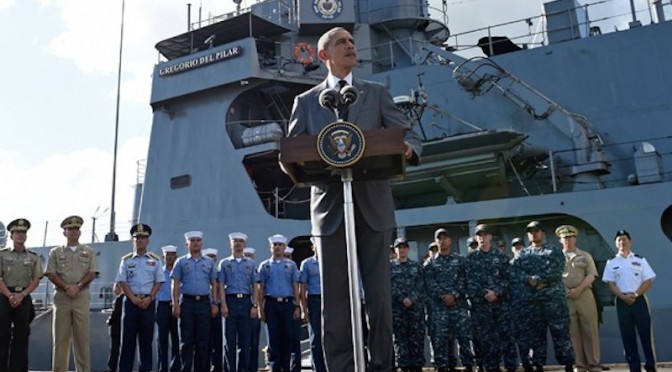
Then US Secretary of State Hillary Clinton with her Filipino counterpart, Albert del Rosario, in June 2011. Washington supports Manila’s arbitration bid and rearmament, but takes no official position on her territorial claims, despite involving former American territory.
This section ends with the DOS study stating that should this interpretation be correct, then “the maritime claims provided for in China’s domestic laws could generally be interpreted to be consistent with the international law of the sea”. This is subject to two caveats, territorial claims by other coastal states over these islands, and Chinese ambiguity concerning the nature of certain geographical features, Beijing not having “clarified which features in the South China Sea it considers to be ‘islands’ (or, alternatively, submerged features) and also which, if any, ‘islands’ it considers to be ‘rocks’ that are not entitled to an EEZ or a continental shelf under paragraph 3 of Article 121 of the LOS Convention”. Some of these features, Scarborough Reef for example, are part of the arbitration proceedings initiated by the Philippines.
2.- “Dashed Line as a National Boundary”
This would mean that Beijing’s intention with the dashed line was to “indicate a national boundary between China and neighboring States”. As supporting evidence for this interpretation, the DOS report explains that “modern Chinese maps and atlases use a boundary symbol to depict the dashed line in the South China Sea”, adding that “the symbology on Chinese maps for land boundaries is the same as the symbology used for the dashes”. Map legends translate boundary symbols as “either ‘national boundary’ or ‘international boundary’ (国界, romanized as guojie)”. Chinese maps also employ “another boundary symbol, which is translated as ‘undefined’ national or international boundary (未定国界, weiding guojie)” but this is never employed for the dashed line.
The report stresses that, under international law, maritime boundaries must be laid down “by agreement (or judicial decision) between neighboring States”, unilateral determination not being acceptable. The text also notes that the “dashes also lack other important hallmarks of a maritime boundary, such as a published list of geographic coordinates and a continuous, unbroken line that separates the maritime space of two countries”. The latter is indeed a noteworthy point, since border lines would indeed seem to need to be continuous by their very nature, rather than just be made up of a number of dashes. This is one of the aspects making it difficult to fit Beijing’s claims with existing categories in the law of the sea. In addition, the report notes that they cannot be a limit to Chinese territorial waters, since they extend beyond 12 nautical miles, and neither can they be a claim to an EEZ, since “dashes 2, 3, and 8” are “beyond 200 nm from any Chinese-claimed land feature”. These last two aspects also make it difficult to see the dashed line as marking one of the categories recognized by UNCLOS. Moving beyond the law, however, and this is something that the DOS report does not address, a certain degree of ambiguity may be seen as beneficial by a state seeking to gradually secure a given maritime territory. Some voices have noted this may have been the US calculus in the San Francisco Treaty. Thus, the technical faults, from an international legal perspective, in China’s dotted line are not necessarily an obstacle to Beijing’s claims, from a practical perspective.
Alex Calvo is a guest professor at Nagoya University (Japan) focusing on security and defence policy, international law, and military history in the Indian-Pacific Ocean. Region. A member of the Center for International Maritime Security (CIMSEC) and Taiwan’s South China Sea Think-Tank, he is currently writing a book about Asia’s role and contribution to the Allied victory in the Great War. He tweets @Alex__Calvo and his work can be foundhere.
[otw_shortcode_button href=”https://cimsec.org/buying-cimsec-war-bonds/18115″ size=”medium” icon_position=”right” shape=”round” color_class=”otw-blue”]Donate to CIMSEC![/otw_shortcode_button]
Despite repeatedly stating that it will not take sides in territorial disputes in East Asia, Washington remains keenly interested in the ultimate fate of the South China Sea. In addition to perennial calls to settle disputes peacefully, regular reminders of the importance of freedom of navigation, military aid to regional actors like the Philippines, and support for a more active policy by non-littoral maritime democracies like India and Japan, the US Department of State (DOS) took a further step late last year by issuing a document, part of its “Limits in the Seas” series. The text seeks to explain the different ways in which one may interpret Chinese maritime claims in the South China Sea (“that the dashes are (1) lines within which China claims sovereignty over the islands, along with the maritime zones those islands would generate under the LOS Convention; (2) national boundary lines; or (3) the limits of so-called historic maritime claims of varying types”). It concludes that the “dashed-line claim does not accord with the international law of the sea” unless “China clarifies that” it “reflects only a claim to islands within that line and any maritime zones.” The text includes supporting Chinese official views, without attributing “to China the views of analysis of non-government sources, such as legal or other Chinese academics.”Concerning this latter restriction, although it is of course official sources which may be considered to be most authoritative when it comes to interpreting a government’s position, we should not forget that administrations in different countries will often resort to “two-track diplomacy” or employ semi or non-official back channels to test the waters and lay the groundwork for future formal negotiations.
[otw_shortcode_button href=”https://cimsec.org/buying-cimsec-war-bonds/18115″ size=”medium” icon_position=”right” shape=”round” color_class=”otw-blue”]Donate to CIMSEC![/otw_shortcode_button]
The object of this five-part series is to summarize the DOS document, while commenting on some of its most relevant features, and where appropriate going beyond the text and examining related aspects of the South China Sea conflict.
Tyranny of History: Can Washington claim not to take sides on Filipino territorial claims?
Before summarizing the “Limits in the Seas” document, we should note that the American policy of not taking sides concerning the ultimate issue of sovereignty could be challenged given Washington’s past sovereignty over the Philippine Archipelago. While this has not been publicly stressed by Manila to date, it could enter the debate as a means of putting more pressure on Washington to adopt a more robust posture.
Chinese Claims and Possible Interpretations According to International Law
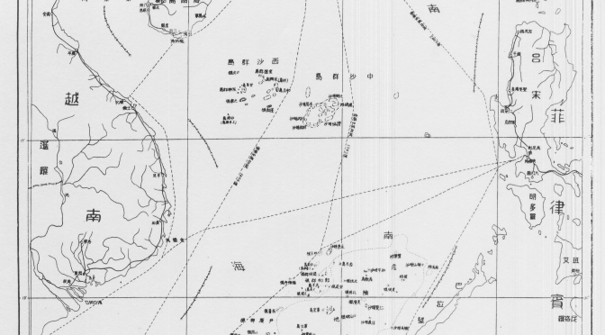
In line with long-standing US demands that Beijing clarify the ultimate nature of her South China Sea claims, the DOS document analyzes those figures within UNCLOS and customary international law which may provide cover to Beijing’s claims. Issued on 5 December 2014, the Department of State paper begins by stressing that “China has not clarified through legislation, proclamation, or other official statements the legal basis or nature of its claim associated with the dashed-line map”, explains the “origins and evolution” of the dashed-line maps, provides a summary of the different maritime zones recognized and regulated by UNCLOS, and then proceeds to explain and discuss three possible interpretations of that claim “and the extent to which those interpretations are consistent with the international law of the sea.” The document contains a number of maps, including (Map 1) that referred to in China’s two May 2009 notesverbales to the UN Secretary General, which stated that “China has indisputable sovereignty over the islands in the South China Sea and the adjacent waters, and enjoys sovereign rights and jurisdiction over the relevant waters as well as the seabed and subsoil thereof. The above position is consistently held by the Chinese government, and is widely known by the international community.”
Nine-dash map attached to China’s two 2009 Notes Verbales.
A Look at Chinese Map Quality and Accuracy
The text first outlines the history of China’s maps of the South China Sea containing dashed lines, starting with a 1947 map published by the Nationalist government, noting that later PRC maps “appear to follow the old maps” (see L. Jinming and L. Dexia, “The Dotted Line on the Chinese Map of the South China Sea: A Note”, Ocean Dev’t & Int’l L., Volume 34, 2003, pp. 287-95, p. 289-290) with two significant changes: the removal of two dashes inside the Gulf of Tonkin (in an area partly delimited by Vietnam and the PRC in 2000) and the addition of a tenth dash to the East of Taiwan. These two changes can be interpreted in different ways, to some degree contradictory. On the one hand, the partial delimitation agreement with Vietnam could be seen as evidence of Chinese pragmatism and flexibility, and proof that it is possible for countries in the region to at least partly settle their disputes by diplomacy. On the other, explicitly encompassing Taiwan with an extra dash may be seen as a reinforcement of Chinese claims on the island not necessarily based on the will of her population. Alternatively, it could simply be a way to more comprehensively encompass the waters and features that Beijing (either directly or via Taipei) wishes to master.
The paper then examines successive Chinese maps from a cartographic perspective, stressing that “China has not published geographic coordinates specifying the location of the dashes. Therefore, all calculations in this study relating to the dashed line are approximate.” A similar criticism has sometimes been made of the San Francisco Treaty.The text also notes that “China does not assign numbers to the dashes,” and therefore those in the study are for “descriptive purposes only.” They “are not uniformly distributed,” being “separated from one another by between 106 (dashes 7 and 8) and 274 (dashes 3 and 4) nautical miles (nm).” This section of the paper stresses that “Nothing in this study is intended to take a definitive position regarding which features in the South China Sea are ‘islands’ under Article 121 of the LOS Convention or whether any such islands are ‘rocks’ under Article 121(3).” This is in line with Washington’s refusal to take sides concerning the ultimate sovereignty disputes in the region. The text notes that the “dashes are located in relatively close proximity to the mainland coasts and coastal islands of the littoral States surrounding the South China Sea,” and explains that, for example, Dash 4 is 24 nm from Borneo’s coast, part of Malaysia. Generally speaking, “the dashes are generally closer to the surrounding coasts of neighboring States than they are to the closest islands within the South China Sea,” and as explained later this is significant when it comes to interpreting the possible meaning of China’s dashed line, since one of the principles of the Law of the Sea is that land dominates the sea, and thus maritime boundaries tend as a general rule to be equidistant. That is, maritime boundaries tend to be roughly half way between two shores belonging to different states.
To hammer home this point, the study includes a set of six maps illustrating this. The report criticizes the technical quality of the PRC maps, saying that they are inconsistent, thus making it “complicated” to describe the dashed line, whose dashes are depicted in different maps “in varying sizes and locations.” Again, this is important in light of possible interpretations of Chinese claims, since this lack of consistency and quality not only obfuscates Chinese claims, introducing an additional measure of ambiguity, but also makes it more difficult to ascertain whether historical claims are being made and whether they are acceptable in light of international law.
The dashes change from map to map, with those “from the 2009 map” being “generally shorter and closer to the coasts of neighboring States” than those in the 1947 map. The dashed lines in these two maps are illustrated and compared in Map 5 of the document. The section concludes noting that the 2009 map, which Beijing distributed to the international community “is also cartographically inconsistent with other published Chinese maps.”
Alex Calvo is a guest professor at Nagoya University (Japan) focusing on security and defence policy, international law, and military history in the Indian-Pacific Ocean. Region. A member of the Center for International Maritime Security (CIMSEC) and Taiwan’s South China Sea Think-Tank, he is currently writing a book about Asia’s role and contribution to the Allied victory in the Great War. He tweets @Alex__Calvo and his work can be foundhere.
[otw_shortcode_button href=”https://cimsec.org/buying-cimsec-war-bonds/18115″ size=”medium” icon_position=”right” shape=”round” color_class=”otw-blue”]Donate to CIMSEC![/otw_shortcode_button]